Narrow Results By
Subject
- Adornment - Lapel Pins 1
- Advertising Medium - Signs and Signboards 1
- Animals - Dogs 1
- Buildings - Religious - Churches 1
- Buildings - Residential - Houses 1
- Buildings - Schools 1
- Construction - Road Construction 2
- Documentary Artifacts - Postcards 1
- Souvenirs 1
- Sports - Lawn Bowling 1
- Sports - Team Sports 1
- Transportation - Trucks 2
![All Saints Anglican Church and Parish Hall, [191-] thumbnail](/media/hpo/_Data/_BVM_Images/1977/198000120004.jpg?width=280)
All Saints Anglican Church and Parish Hall
https://search.heritageburnaby.ca/link/museumdescription3032
- Repository
- Burnaby Village Museum
- Date
- [191-]
- Collection/Fonds
- Burnaby Village Museum Photograph collection
- Description Level
- Item
- Physical Description
- 1 photograph : b&w postcard ; 8.8 x 13.9 cm
- Scope and Content
- Photographic postcard of two buildings identified as All Saints Anglican Church and Parish Hall. There are two men in work clothes (cover-alls) standing in between the two buildings. There is a ladder going up to the roof of one building.
- Repository
- Burnaby Village Museum
- Collection/Fonds
- Burnaby Village Museum Photograph collection
- Description Level
- Item
- Physical Description
- 1 photograph : b&w postcard ; 8.8 x 13.9 cm
- Scope and Content
- Photographic postcard of two buildings identified as All Saints Anglican Church and Parish Hall. There are two men in work clothes (cover-alls) standing in between the two buildings. There is a ladder going up to the roof of one building.
- Geographic Access
- Royal Oak Avenue
- Street Address
- 7405 Royal Oak Avenue
- Accession Code
- HV980.12.4
- Access Restriction
- No restrictions
- Reproduction Restriction
- May be restricted by third party rights
- Date
- [191-]
- Media Type
- Photograph
- Historic Neighbourhood
- Alta-Vista (Historic Neighbourhood)
- Planning Study Area
- Sussex-Nelson Area
- Scan Resolution
- 600
- Scan Date
- 2023-09-12
- Notes
- Title based on contents of photograph
Images
![All Saints Anglican Church and Parish Hall, [191-] thumbnail](/media/hpo/_Data/_BVM_Images/1977/198000120004.jpg)
![Burnaby's first lawn bowlers, [1916] thumbnail](/media/hpo/_Data/_BVM_Images/1974/197600710001.jpg?width=280)
Burnaby's first lawn bowlers
https://search.heritageburnaby.ca/link/museumdescription746
- Repository
- Burnaby Village Museum
- Date
- [1916]
- Collection/Fonds
- Burnaby Village Museum Photograph collection
- Description Level
- Item
- Physical Description
- 1 photograph : sepia ; 19 x 24 cm (sight), in mat 29 x 34 cm + 1 p.
- Scope and Content
- Photograph of lawn bowlers gathered together at the first bowling green in Burnaby, located at Victory Street and Gray Avenue (on Stan Wood's property). Standing in the back row (from left) are; M. Van George, Reverend A.C. Cameron, George Gascarth, Bennett, Oliver Goodacre and John Brown. Sitting …
- Repository
- Burnaby Village Museum
- Collection/Fonds
- Burnaby Village Museum Photograph collection
- Description Level
- Item
- Physical Description
- 1 photograph : sepia ; 19 x 24 cm (sight), in mat 29 x 34 cm + 1 p.
- Scope and Content
- Photograph of lawn bowlers gathered together at the first bowling green in Burnaby, located at Victory Street and Gray Avenue (on Stan Wood's property). Standing in the back row (from left) are; M. Van George, Reverend A.C. Cameron, George Gascarth, Bennett, Oliver Goodacre and John Brown. Sitting in the front row are; J.N. Durrell, Charles Mirren McInnes Harper, A.E.S. "Stan" Wood, William "Will" Taylor, and Edward Lumley Wriglesworth. Most of the men are wearing suit vests and pocket watches.
- Names
- Cameron, Reverend A.C.
- Gasgarth, George
- Goodacre, Oliver
- Brown, John
- Harper, Jack
- Wood, Anthony Ewart Stanley "Stan"
- Taylor, Will
- Harper, Charles Mirren McInnes
- Durrell, J.N.
- Wriglesworth, Edward Lumley
- Geographic Access
- Victory Street
- Gray Avenue
- Accession Code
- HV976.71.1
- Access Restriction
- No restrictions
- Reproduction Restriction
- No known restrictions
- Date
- [1916]
- Media Type
- Photograph
- Historic Neighbourhood
- Alta-Vista (Historic Neighbourhood)
- Planning Study Area
- Sussex-Nelson Area
- Scan Resolution
- 600
- Scan Date
- 1/6/2010
- Scale
- 100
- Photographer
- Rognon, Orville Jackson
- Notes
- Title based on contents of photograph
- Window mat and backing are glued together
- Photographer's writing on recto of photograph reads: "Photo by Rognon"
- 1 page accompanying identifies individuals
Images
![Burnaby's first lawn bowlers, [1916] thumbnail](/media/hpo/_Data/_BVM_Images/1974/197600710001.jpg)

Jubilee Avenue
https://search.heritageburnaby.ca/link/museumdescription1699
- Repository
- Burnaby Village Museum
- Date
- May 1955
- Collection/Fonds
- Burnaby Village Museum Photograph collection
- Description Level
- Item
- Physical Description
- 1 photograph : b&w ; 7.5 x 7.5 cm
- Scope and Content
- Photograph of a section of Jubilee Avenue; the entire span of the paved road has been dug up and two trucks are visible driving over the muddy ground.
- Repository
- Burnaby Village Museum
- Collection/Fonds
- Burnaby Village Museum Photograph collection
- Description Level
- Item
- Physical Description
- 1 photograph : b&w ; 7.5 x 7.5 cm
- Scope and Content
- Photograph of a section of Jubilee Avenue; the entire span of the paved road has been dug up and two trucks are visible driving over the muddy ground.
- Geographic Access
- Jubilee Avenue
- Accession Code
- BV004.7.5
- Access Restriction
- Restricted access
- Reproduction Restriction
- May be restricted by third party rights
- Date
- May 1955
- Media Type
- Photograph
- Historic Neighbourhood
- Alta-Vista (Historic Neighbourhood)
- Planning Study Area
- Sussex-Nelson Area
- Related Material
- For another photograph of roadwork scene at Jubilee Avenue, see BV004.7.6
- Scan Resolution
- 600
- Scan Date
- 09-Jun-09
- Scale
- 100
- Notes
- Title based on contents of photograph
- Note in blue ink on verso of photograph reads: "Jubilee Ave/ May 1955"
Images


Jubilee Avenue
https://search.heritageburnaby.ca/link/museumdescription1700
- Repository
- Burnaby Village Museum
- Date
- May 1955
- Collection/Fonds
- Burnaby Village Museum Photograph collection
- Description Level
- Item
- Physical Description
- 1 photograph : b&w ; 7.5 x 7.5 cm
- Scope and Content
- Photograph of a section of Jubilee Avenue; the entire span of the paved road has been dug up and a line of dump trucks are driving over the muddy ground in the distance.
- Repository
- Burnaby Village Museum
- Collection/Fonds
- Burnaby Village Museum Photograph collection
- Description Level
- Item
- Physical Description
- 1 photograph : b&w ; 7.5 x 7.5 cm
- Scope and Content
- Photograph of a section of Jubilee Avenue; the entire span of the paved road has been dug up and a line of dump trucks are driving over the muddy ground in the distance.
- Geographic Access
- Jubilee Avenue
- Accession Code
- BV004.7.6
- Access Restriction
- Restricted access
- Reproduction Restriction
- May be restricted by third party rights
- Date
- May 1955
- Media Type
- Photograph
- Historic Neighbourhood
- Alta-Vista (Historic Neighbourhood)
- Planning Study Area
- Sussex-Nelson Area
- Related Material
- For another photograph of roadwork scene at Jubilee Avenue, see BV004.7.5
- Scan Resolution
- 600
- Scan Date
- 09-Jun-09
- Notes
- Title based on contents of photograph
- Note in blue ink on verso of photograph reads: "At its worst/ Jubilee Ave/ South Burnaby/ May 1955"
Images


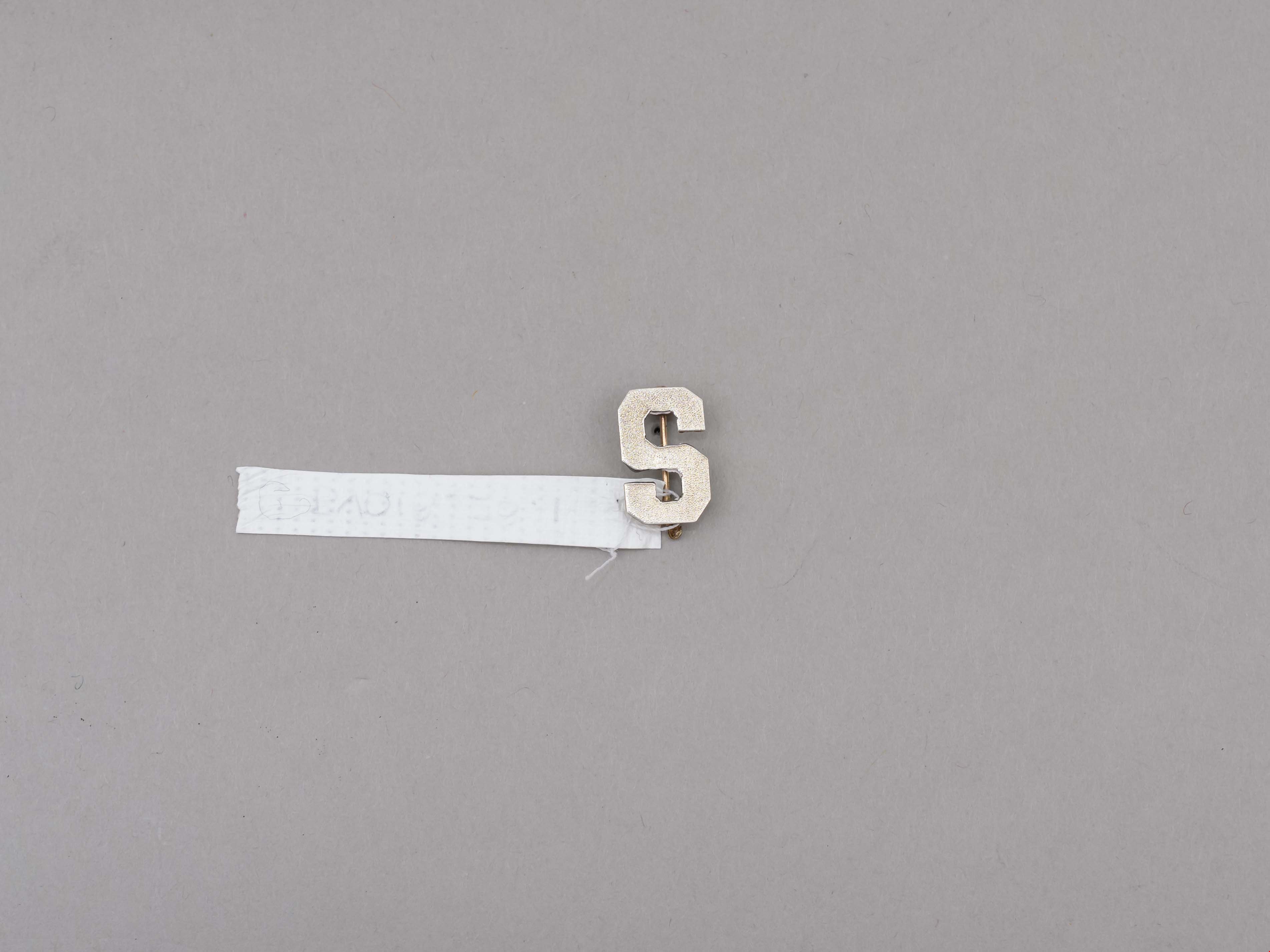
lapel pin
https://search.heritageburnaby.ca/link/museumartifact89260
- Repository
- Burnaby Village Museum
- Accession Code
- BV018.28.1
- Description
- lapel pin; silver "S" with locking pin back; letter "S" represents Sussex Avenue School; ca. 1960's.
- Object History
- Donor attended Sussex Avenue School in 1964-65 for grade 5, 1965-66 for grade 6 and 1966-1967 for grade 7.
- Donor attended McPherson Park Junior Secondary School for grades 8-10 from Sept 1967-June 1970. The double academic and athletic crests and the "Mc" pin were received in grade 10.
- Category
- 03. Personal Artifacts
- Subjects
- Adornment - Lapel Pins
- Souvenirs
- Names
- Sussex Avenue School
- Geographic Access
- Irmin Street
- Street Address
- 4443 Irmin Street
- Historic Neighbourhood
- Alta Vista (Historic Neighbourhood)
- Planning Study Area
- Sussex-Nelson Area
Images

Municipality of Burnaby - Volume XVIII and Volume XIX
https://search.heritageburnaby.ca/link/museumdescription8683
- Repository
- Burnaby Village Museum
- Date
- May 1927
- Collection/Fonds
- Burnaby Village Museum Map collection
- Description Level
- File
- Physical Description
- 2 plans on 2 sheets : col. lithographic prints ; 63.5 x 53.5 cm folded to 53 x 31.5 cm
- Scope and Content
- File consists of two pages of plans removed from a bound book containing a series of fire insurance plans of the Municipality of Burnaby. Plan "1832" is from "GREATER VANCOUVER B.C. / VOLUME XVIII / Municipality of Burnaby / May, 1927" and covers District Lots: 98 and 28. Plan "K" is part of a key …
- Repository
- Burnaby Village Museum
- Collection/Fonds
- Burnaby Village Museum Map collection
- Description Level
- File
- Physical Description
- 2 plans on 2 sheets : col. lithographic prints ; 63.5 x 53.5 cm folded to 53 x 31.5 cm
- Material Details
- Scale [1:1200] to [1:6000]
- Scope and Content
- File consists of two pages of plans removed from a bound book containing a series of fire insurance plans of the Municipality of Burnaby. Plan "1832" is from "GREATER VANCOUVER B.C. / VOLUME XVIII / Municipality of Burnaby / May, 1927" and covers District Lots: 98 and 28. Plan "K" is part of a key plan "GREATER VANCOUVER B.C. / Surveyed VOLUME XIX May 1927 / MUNICIPALITY OF / BURNABY / PLAN DEPT. British Columbia Ins. Underwriters Association / FIRE BRANCH / KEY PLAN", "Scale 500 FT = 1 INCH / FOR REPORT SEE VOL. XV" covering plans: 1901 to 1914 and District Lots: 161; 164 to 167; 155c; 155; 172 and 173.
- Responsibility
- British Columbia Underwriters' Association
- Accession Code
- HV972.111.5
- Access Restriction
- No restrictions
- Reproduction Restriction
- May be restricted by third party rights
- Date
- May 1927
- Media Type
- Cartographic Material
- Historic Neighbourhood
- East Burnaby (Historic Neighbourhood)
- Central Park (Historic Neighbourhood)
- Fraser Arm (Historic Neighbourhood)
- Alta Vista (Historic Neighbourhood)
- Planning Study Area
- Windsor Area
- Marlborough Area
- Second Street Area
- Big Bend Area
- Sussex-Nelson Area
- Scan Resolution
- 400
- Scan Date
- 2021-11-18
- Notes
- Title based on content of plans
- See also BV987.1.70d for revised versions of plans
- Scale is measured 1 inch = 500 feet
Zoomable Images


Nelson Avenue School site
https://search.heritageburnaby.ca/link/museumdescription11135
- Repository
- Burnaby Village Museum
- Date
- April 12, 1915
- Collection/Fonds
- Ronald G. Scobbie collection
- Description Level
- Item
- Physical Description
- 1 survey plan : blueprint on paper ; 56 x 54 cm
- Scope and Content
- Survey plan of "Nelson Avenue School Site / Burnaby Municipality" "Being the south half of Block 19, except therefrom the north 33 feet, of Lot 99, Gp. 1. New Westminster District".
- Repository
- Burnaby Village Museum
- Collection/Fonds
- Ronald G. Scobbie collection
- Description Level
- Item
- Physical Description
- 1 survey plan : blueprint on paper ; 56 x 54 cm
- Material Details
- Scale 40 feet = 1 inch
- Scope and Content
- Survey plan of "Nelson Avenue School Site / Burnaby Municipality" "Being the south half of Block 19, except therefrom the north 33 feet, of Lot 99, Gp. 1. New Westminster District".
- Creator
- McGugan, Donald Johnston
- Subjects
- Buildings - Schools
- Names
- Nelson Avenue School
- Responsibility
- Burnett & McGugan, Engineers and Surveyors
- Geographic Access
- Irmin Street
- Street Address
- 4850 Irmin Street
- Accession Code
- BV003.83.14
- Access Restriction
- No restrictions
- Reproduction Restriction
- No known restrictions
- Date
- April 12, 1915
- Media Type
- Cartographic Material
- Historic Neighbourhood
- Alta Vista (Historic Neighbourhood)
- Planning Study Area
- Sussex-Nelson Area
- Scan Resolution
- 440
- Scan Date
- 22-Dec-2020
- Scale
- 100
- Notes
- Title based on contents of plan
- Note in black ink on verso of plan reads: "1745"
- Oath on plan reads: "I, D.G. McGugan..." "...and did person- ally superintend the survey..." "...completed on the 5th day of March 1915"; signed by D.J. McGugan, notarized by "R.E. Chapman", sworn "...12th day of April 1915" "Burnett and McGugan" "B.C. Land Surveyors Etc. New Westminster, B.C.."
Images

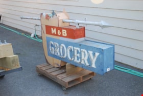
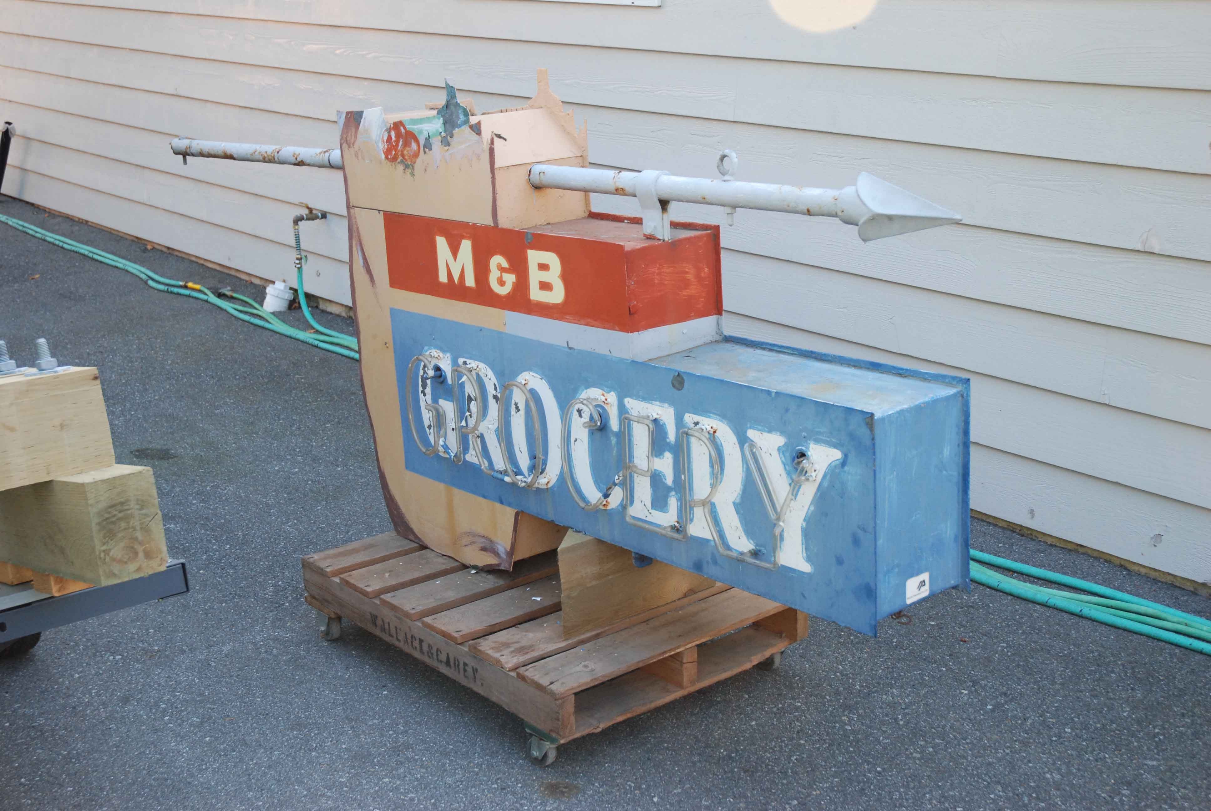
neon sign
https://search.heritageburnaby.ca/link/museumartifact83422
- Repository
- Burnaby Village Museum
- Accession Code
- BV013.15.1
- Description
- Grocery sign The sign is from a neighbourhood grocery on Royal Oak at the Skytrain line: 6949 Royal Oak Avenue. The bulk of the sign is rectangular with a grocery bag and contents extending above the top edge of the sign. The words "M & B / GROCERY" are written in white text, with "GROCERY" highlighted in neon. The sign was suspended from a horizontal pole with a spear like finial that was mounted at the front of the roof or the store.
- Province Made
- British Columbia
- Site/City Made
- Vancouver
- Historic Neighbourhood
- Central Park (Historic Neighbourhood)
- Planning Study Area
- Sussex-Nelson Area
Images
![Wray family, [1919] thumbnail](/media/hpo/_Data/_BVM_Images/1985/1985_0439_0002_001.jpg?width=280)
Wray family
https://search.heritageburnaby.ca/link/museumdescription215
- Repository
- Burnaby Village Museum
- Date
- [1919]
- Collection/Fonds
- Burnaby Village Museum Photograph collection
- Description Level
- Item
- Physical Description
- 1 photograph : sepia
- Scope and Content
- Photograph of the Wray family and friends on the verandah of their home at 2351 Dow Road (old street number), during the summer of 1919. The three depicted in the centre of the photograph are (l to r) a daughter of Mr and Mrs Wray, Mr. Edward Wray, and Mrs. Wray. On either side of them, there is a …
- Repository
- Burnaby Village Museum
- Collection/Fonds
- Burnaby Village Museum Photograph collection
- Description Level
- Item
- Physical Description
- 1 photograph : sepia
- Material Details
- inscribed in pencil, verso, t. "Mr + Mrs Wray + their daughter (middle/ three) on verandah of their home/ at 2351 Dow Rd.", l.l. "taken - summer of/ 1919"
- Scope and Content
- Photograph of the Wray family and friends on the verandah of their home at 2351 Dow Road (old street number), during the summer of 1919. The three depicted in the centre of the photograph are (l to r) a daughter of Mr and Mrs Wray, Mr. Edward Wray, and Mrs. Wray. On either side of them, there is a young woman, and a boy is sitting on the top of the stairs leading to the verandah. There is also a dog standing on the steps.
- Subjects
- Animals - Dogs
- Geographic Access
- Dow Avenue
- Street Address
- 6926 Dow Avenue
- Accession Code
- BV985.439.2
- Date
- [1919]
- Media Type
- Photograph
- Historic Neighbourhood
- Alta-Vista (Historic Neighbourhood)
- Planning Study Area
- Sussex-Nelson Area
- Scan Resolution
- 600
- Scan Date
- 16-Jan-24
- Scale
- 100
- Notes
- Title based on contents of photograph
Images
![Wray family, [1919] thumbnail](/media/hpo/_Data/_BVM_Images/1985/1985_0439_0002_001.jpg)
![Wray family house, [192-] thumbnail](/media/hpo/_Data/_BVM_Images/1985/1985_0439_0003_001.jpg?width=280)
Wray family house
https://search.heritageburnaby.ca/link/museumdescription216
- Repository
- Burnaby Village Museum
- Date
- [192-]
- Collection/Fonds
- Burnaby Village Museum Photograph collection
- Description Level
- Item
- Physical Description
- 1 photograph : b&w
- Scope and Content
- Photograph of the Wray family house located at 2351 Dow Road (old street number). Note the ladders and minor construction on the verandah. There are brambles, weeds and tall plants growing around the house.
- Repository
- Burnaby Village Museum
- Collection/Fonds
- Burnaby Village Museum Photograph collection
- Description Level
- Item
- Physical Description
- 1 photograph : b&w
- Material Details
- inscribed in pencil, verso, t. "Home of Mr + Mrs Edward Wray/ 2351 Dow Road. (with half/ of verandah filled in)", stamped upside down, l.r. "0020"
- The name "velox" is lightly printed on the back of the photo paper: thus, the photograph is printed on Kodak velox photo paper made in early 1900s for amateur photography.
- Scope and Content
- Photograph of the Wray family house located at 2351 Dow Road (old street number). Note the ladders and minor construction on the verandah. There are brambles, weeds and tall plants growing around the house.
- Subjects
- Buildings - Residential - Houses
- Geographic Access
- Dow Avenue
- Street Address
- 6926 Dow Avenue
- Accession Code
- BV985.439.3
- Date
- [192-]
- Media Type
- Photograph
- Historic Neighbourhood
- Alta-Vista (Historic Neighbourhood)
- Planning Study Area
- Sussex-Nelson Area
- Scan Resolution
- 600
- Scan Date
- 16-Jan-24
- Scale
- 100
- Notes
- Title based on contents of photograph
Images
![Wray family house, [192-] thumbnail](/media/hpo/_Data/_BVM_Images/1985/1985_0439_0003_001.jpg)