Narrow Results By
Subject
- Advertising Medium - Signs and Signboards 3
- Aerial Photographs 1
- Animals - Dogs 2
- Buildings - Commercial 2
- Buildings - Commercial - Barber Shops 5
- Buildings - Commercial - Grocery Stores 2
- Buildings - Commercial - Hotels and Motels 1
- Buildings - Commercial - Service Stations 2
- Buildings - Recreational - Community Halls 1
- Buildings - Religious - Churches 2
- Buildings - Residential - Houses 6
- Buildings - Schools 4
![All Saints Anglican Church and Parish Hall, [191-] thumbnail](/media/hpo/_Data/_BVM_Images/1977/198000120004.jpg?width=280)
All Saints Anglican Church and Parish Hall
https://search.heritageburnaby.ca/link/museumdescription3032
- Repository
- Burnaby Village Museum
- Date
- [191-]
- Collection/Fonds
- Burnaby Village Museum Photograph collection
- Description Level
- Item
- Physical Description
- 1 photograph : b&w postcard ; 8.8 x 13.9 cm
- Scope and Content
- Photographic postcard of two buildings identified as All Saints Anglican Church and Parish Hall. There are two men in work clothes (cover-alls) standing in between the two buildings. There is a ladder going up to the roof of one building.
- Repository
- Burnaby Village Museum
- Collection/Fonds
- Burnaby Village Museum Photograph collection
- Description Level
- Item
- Physical Description
- 1 photograph : b&w postcard ; 8.8 x 13.9 cm
- Scope and Content
- Photographic postcard of two buildings identified as All Saints Anglican Church and Parish Hall. There are two men in work clothes (cover-alls) standing in between the two buildings. There is a ladder going up to the roof of one building.
- Geographic Access
- Royal Oak Avenue
- Street Address
- 7405 Royal Oak Avenue
- Accession Code
- HV980.12.4
- Access Restriction
- No restrictions
- Reproduction Restriction
- May be restricted by third party rights
- Date
- [191-]
- Media Type
- Photograph
- Historic Neighbourhood
- Alta-Vista (Historic Neighbourhood)
- Planning Study Area
- Sussex-Nelson Area
- Scan Resolution
- 600
- Scan Date
- 2023-09-12
- Notes
- Title based on contents of photograph
Images
![All Saints Anglican Church and Parish Hall, [191-] thumbnail](/media/hpo/_Data/_BVM_Images/1977/198000120004.jpg)
Baker family home
https://search.heritageburnaby.ca/link/archivedescription35748
- Repository
- City of Burnaby Archives
- Date
- 1911 (date of original), copied 1986
- Collection/Fonds
- Burnaby Historical Society fonds
- Description Level
- Item
- Physical Description
- 1 photograph : b&w ; 12.7 x 17.8 cm print
- Scope and Content
- Photograph of the Baker family home, 1643 Arthur Avenue (later renumbered 7666 Arthur Avenue). It was built by George Charles Baker.
- Repository
- City of Burnaby Archives
- Date
- 1911 (date of original), copied 1986
- Collection/Fonds
- Burnaby Historical Society fonds
- Subseries
- Pioneer Tales subseries
- Physical Description
- 1 photograph : b&w ; 12.7 x 17.8 cm print
- Description Level
- Item
- Record No.
- 204-606
- Access Restriction
- No restrictions
- Reproduction Restriction
- No known restrictions
- Accession Number
- BHS1988-03
- Scope and Content
- Photograph of the Baker family home, 1643 Arthur Avenue (later renumbered 7666 Arthur Avenue). It was built by George Charles Baker.
- Subjects
- Buildings - Residential - Houses
- Media Type
- Photograph
- Notes
- Title based on contents of photograph
- Geographic Access
- Arthur Avenue
- Street Address
- 7666 Arthur Avenue
- Historic Neighbourhood
- Alta-Vista (Historic Neighbourhood)
- Planning Study Area
- Sussex-Nelson Area
Images


BC Tel Truck
https://search.heritageburnaby.ca/link/archivedescription79443
- Repository
- City of Burnaby Archives
- Date
- October 13, 1976
- Collection/Fonds
- Burnaby Public Library Contemporary Visual Archive Project
- Description Level
- Item
- Physical Description
- 1 photograph : b&w ; 11 x 16 cm mounted on cardboard
- Scope and Content
- Photograph shows a BC Tel truck parked in the 4200 block Rumble Street.
- Repository
- City of Burnaby Archives
- Date
- October 13, 1976
- Collection/Fonds
- Burnaby Public Library Contemporary Visual Archive Project
- Physical Description
- 1 photograph : b&w ; 11 x 16 cm mounted on cardboard
- Description Level
- Item
- Record No.
- 556-295
- Access Restriction
- No restrictions
- Reproduction Restriction
- Reproduce for fair dealing purposes only
- Accession Number
- 2013-13
- Scope and Content
- Photograph shows a BC Tel truck parked in the 4200 block Rumble Street.
- Subjects
- Transportation - Trucks
- Media Type
- Photograph
- Photographer
- Ross, Martha
- Notes
- Scope note taken directly from BPL photograph description.
- 1 b&w copy negative : 10 x 12.5 cm accompanying
- Geographic Access
- Rumble Street
- Historic Neighbourhood
- Alta-Vista (Historic Neighbourhood)
- Planning Study Area
- Sussex-Nelson Area
Images


BC Tel Worker
https://search.heritageburnaby.ca/link/archivedescription79444
- Repository
- City of Burnaby Archives
- Date
- October 13, 1976
- Collection/Fonds
- Burnaby Public Library Contemporary Visual Archive Project
- Description Level
- Item
- Physical Description
- 1 photograph : b&w ; 11 x 16 cm mounted on cardboard
- Scope and Content
- Photograph shows a BC Tel employee working on lines on a pole in the 4200 Block Rumble Street.
- Repository
- City of Burnaby Archives
- Date
- October 13, 1976
- Collection/Fonds
- Burnaby Public Library Contemporary Visual Archive Project
- Physical Description
- 1 photograph : b&w ; 11 x 16 cm mounted on cardboard
- Description Level
- Item
- Record No.
- 556-296
- Access Restriction
- No restrictions
- Reproduction Restriction
- Reproduce for fair dealing purposes only
- Accession Number
- 2013-13
- Scope and Content
- Photograph shows a BC Tel employee working on lines on a pole in the 4200 Block Rumble Street.
- Subjects
- Transportation - Trucks
- Media Type
- Photograph
- Photographer
- Ross, Martha
- Notes
- Scope note taken directly from BPL photograph description.
- 1 b&w copy negative : 10 x 12.5 cm accompanying
- Geographic Access
- Rumble Street
- Historic Neighbourhood
- Alta-Vista (Historic Neighbourhood)
- Planning Study Area
- Sussex-Nelson Area
Images


BC Tel Worker
https://search.heritageburnaby.ca/link/archivedescription79445
- Repository
- City of Burnaby Archives
- Date
- October 13, 1976
- Collection/Fonds
- Burnaby Public Library Contemporary Visual Archive Project
- Description Level
- Item
- Physical Description
- 1 photograph : b&w ; 11 x 16 cm mounted on cardboard
- Scope and Content
- Photograph shows a BC Tel employee, Dave Gulkison, in the 4200 Block Rumble Street.
- Repository
- City of Burnaby Archives
- Date
- October 13, 1976
- Collection/Fonds
- Burnaby Public Library Contemporary Visual Archive Project
- Physical Description
- 1 photograph : b&w ; 11 x 16 cm mounted on cardboard
- Description Level
- Item
- Record No.
- 556-297
- Access Restriction
- No restrictions
- Reproduction Restriction
- Reproduce for fair dealing purposes only
- Accession Number
- 2013-13
- Scope and Content
- Photograph shows a BC Tel employee, Dave Gulkison, in the 4200 Block Rumble Street.
- Subjects
- Transportation - Trucks
- Media Type
- Photograph
- Photographer
- Ross, Martha
- Notes
- Scope note taken directly from BPL photograph description.
- 1 b&w copy negative : 10 x 12.5 cm accompanying
- Geographic Access
- Rumble Street
- Historic Neighbourhood
- Alta-Vista (Historic Neighbourhood)
- Planning Study Area
- Sussex-Nelson Area
Images


Bickerton family home
https://search.heritageburnaby.ca/link/archivedescription36800
- Repository
- City of Burnaby Archives
- Date
- 1911 (date of original), copied 1992
- Collection/Fonds
- Burnaby Historical Society fonds
- Description Level
- Item
- Physical Description
- 1 photograph : b&w ; 8.9 x 12.7 cm print
- Scope and Content
- Photograph of the Bickerton family home at 2125 Nelson Avenue (later renumberd 7082 Nelson Avenue) near Victory Street, built in 1905 In front of the home are Edgar and Jane Bickerton, and three of their children: Edward, Nancy and Patricia.
- Repository
- City of Burnaby Archives
- Date
- 1911 (date of original), copied 1992
- Collection/Fonds
- Burnaby Historical Society fonds
- Subseries
- Burnaby Centennial Anthology subseries
- Physical Description
- 1 photograph : b&w ; 8.9 x 12.7 cm print
- Description Level
- Item
- Record No.
- 315-257
- Access Restriction
- No restrictions
- Reproduction Restriction
- No known restrictions
- Accession Number
- BHS1994-04
- Scope and Content
- Photograph of the Bickerton family home at 2125 Nelson Avenue (later renumberd 7082 Nelson Avenue) near Victory Street, built in 1905 In front of the home are Edgar and Jane Bickerton, and three of their children: Edward, Nancy and Patricia.
- Names
- Bickerton, Edgar "Ed"
- Bickerton, Edward "Ed"
- Bickerton, Jane
- Bickerton, Nancy "Nan"
- Bickerton, Patricia "Pat"
- Media Type
- Photograph
- Notes
- Title based on contents of photograph
- Geographic Access
- Nelson Avenue
- Street Address
- 7082 Nelson Avenue
- Historic Neighbourhood
- Alta-Vista (Historic Neighbourhood)
- Planning Study Area
- Sussex-Nelson Area
Images

![Burnaby's first lawn bowlers, [1916] thumbnail](/media/hpo/_Data/_BVM_Images/1974/197600710001.jpg?width=280)
Burnaby's first lawn bowlers
https://search.heritageburnaby.ca/link/museumdescription746
- Repository
- Burnaby Village Museum
- Date
- [1916]
- Collection/Fonds
- Burnaby Village Museum Photograph collection
- Description Level
- Item
- Physical Description
- 1 photograph : sepia ; 19 x 24 cm (sight), in mat 29 x 34 cm + 1 p.
- Scope and Content
- Photograph of lawn bowlers gathered together at the first bowling green in Burnaby, located at Victory Street and Gray Avenue (on Stan Wood's property). Standing in the back row (from left) are; M. Van George, Reverend A.C. Cameron, George Gascarth, Bennett, Oliver Goodacre and John Brown. Sitting …
- Repository
- Burnaby Village Museum
- Collection/Fonds
- Burnaby Village Museum Photograph collection
- Description Level
- Item
- Physical Description
- 1 photograph : sepia ; 19 x 24 cm (sight), in mat 29 x 34 cm + 1 p.
- Scope and Content
- Photograph of lawn bowlers gathered together at the first bowling green in Burnaby, located at Victory Street and Gray Avenue (on Stan Wood's property). Standing in the back row (from left) are; M. Van George, Reverend A.C. Cameron, George Gascarth, Bennett, Oliver Goodacre and John Brown. Sitting in the front row are; J.N. Durrell, Charles Mirren McInnes Harper, A.E.S. "Stan" Wood, William "Will" Taylor, and Edward Lumley Wriglesworth. Most of the men are wearing suit vests and pocket watches.
- Names
- Cameron, Reverend A.C.
- Gasgarth, George
- Goodacre, Oliver
- Brown, John
- Harper, Jack
- Wood, Anthony Ewart Stanley "Stan"
- Taylor, Will
- Harper, Charles Mirren McInnes
- Durrell, J.N.
- Wriglesworth, Edward Lumley
- Geographic Access
- Victory Street
- Gray Avenue
- Accession Code
- HV976.71.1
- Access Restriction
- No restrictions
- Reproduction Restriction
- No known restrictions
- Date
- [1916]
- Media Type
- Photograph
- Historic Neighbourhood
- Alta-Vista (Historic Neighbourhood)
- Planning Study Area
- Sussex-Nelson Area
- Scan Resolution
- 600
- Scan Date
- 1/6/2010
- Scale
- 100
- Photographer
- Rognon, Orville Jackson
- Notes
- Title based on contents of photograph
- Window mat and backing are glued together
- Photographer's writing on recto of photograph reads: "Photo by Rognon"
- 1 page accompanying identifies individuals
Images
![Burnaby's first lawn bowlers, [1916] thumbnail](/media/hpo/_Data/_BVM_Images/1974/197600710001.jpg)

Clearing Gough Family Lot
https://search.heritageburnaby.ca/link/archivedescription35486
- Repository
- City of Burnaby Archives
- Date
- 1912 (date of original), copied 1986
- Collection/Fonds
- Burnaby Historical Society fonds
- Description Level
- Item
- Physical Description
- 1 photograph : b&w ; 12.7 x 17.8 cm print
- Scope and Content
- Photograph of the Gough family and relatives clearing the lot for the family home on Nelson Avenue, Alta Vista. Identified in the photo (back row, centre) Donald Gough. Others in picture are aunts and uncles named Evans. Donald was the son of Agnes Gough and her husband William, who settled here…
- Repository
- City of Burnaby Archives
- Date
- 1912 (date of original), copied 1986
- Collection/Fonds
- Burnaby Historical Society fonds
- Subseries
- Pioneer Tales subseries
- Physical Description
- 1 photograph : b&w ; 12.7 x 17.8 cm print
- Description Level
- Item
- Record No.
- 204-344
- Access Restriction
- No restrictions
- Reproduction Restriction
- No known restrictions
- Accession Number
- BHS1988-03
- Scope and Content
- Photograph of the Gough family and relatives clearing the lot for the family home on Nelson Avenue, Alta Vista. Identified in the photo (back row, centre) Donald Gough. Others in picture are aunts and uncles named Evans. Donald was the son of Agnes Gough and her husband William, who settled here at 2119 Nelson Avenue (later 7126 Nelson Avenue).
- Subjects
- Land Clearing
- Names
- Evans Family
- Gough, Donald
- Media Type
- Photograph
- Notes
- Title based on contents of photograph
- Annotation at top of photograph reads, "Nelson & Victory Sts - 1912"
- Geographic Access
- Nelson Avenue
- Street Address
- 7126 Nelson Avenue
- Historic Neighbourhood
- Alta-Vista (Historic Neighbourhood)
- Planning Study Area
- Sussex-Nelson Area
Images


Corner of Nelson and Patrick
https://search.heritageburnaby.ca/link/archivedescription79695
- Repository
- City of Burnaby Archives
- Date
- September 27, 1976
- Collection/Fonds
- Burnaby Public Library Contemporary Visual Archive Project
- Description Level
- Item
- Physical Description
- 1 photograph : b&w ; 11 x 16 cm mounted on cardboard
- Scope and Content
- Photograph shows young children on the corner of Nelson Avenue and Patrick Place.
- Repository
- City of Burnaby Archives
- Date
- September 27, 1976
- Collection/Fonds
- Burnaby Public Library Contemporary Visual Archive Project
- Physical Description
- 1 photograph : b&w ; 11 x 16 cm mounted on cardboard
- Description Level
- Item
- Record No.
- 556-389
- Access Restriction
- No restrictions
- Reproduction Restriction
- Reproduce for fair dealing purposes only
- Accession Number
- 2013-13
- Scope and Content
- Photograph shows young children on the corner of Nelson Avenue and Patrick Place.
- Media Type
- Photograph
- Photographer
- Ross, Martha
- Notes
- Scope note taken directly from BPL photograph description.
- 1 b&w copy negative : 10 x 12.5 cm accompanying
- Geographic Access
- Nelson Avenue
- Patrick Place
- Historic Neighbourhood
- Alta-Vista (Historic Neighbourhood)
- Planning Study Area
- Sussex-Nelson Area
Images


Crossing Royal Oak & Rumble Street
https://search.heritageburnaby.ca/link/archivedescription93686
- Repository
- City of Burnaby Archives
- Date
- May 19, 1978
- Collection/Fonds
- Burnaby Public Library Contemporary Visual Archive Project
- Description Level
- Item
- Physical Description
- 1 photograph : b&w ; 12.5 x 17.5 cm
- Scope and Content
- Photograph of the intersection of Royal Oak Avenue and Rumble Street. Cars and pedestrians are crossing the intersection, and the signs for businesses TD Bank, Standard Oil/Chevron gas station, Gulf gas station, and Baxter's Market are visible. The photograph is taken from a corner of the intersect…
- Repository
- City of Burnaby Archives
- Date
- May 19, 1978
- Collection/Fonds
- Burnaby Public Library Contemporary Visual Archive Project
- Physical Description
- 1 photograph : b&w ; 12.5 x 17.5 cm
- Description Level
- Item
- Record No.
- 556-643
- Access Restriction
- No restrictions
- Reproduction Restriction
- Reproduce for fair dealing purposes only
- Accession Number
- 2017-57
- Scope and Content
- Photograph of the intersection of Royal Oak Avenue and Rumble Street. Cars and pedestrians are crossing the intersection, and the signs for businesses TD Bank, Standard Oil/Chevron gas station, Gulf gas station, and Baxter's Market are visible. The photograph is taken from a corner of the intersection, facing southeast.
- Subjects
- Geographic Features - Roads
- Advertising Medium - Signs and Signboards
- Buildings - Commercial - Service Stations
- Transportation - Automobiles
- Buildings - Commercial
- Media Type
- Photograph
- Photographer
- van Mannen, Mark
- Notes
- Title taken from project information form
- Accompanied by a project information form and 1 photograph (b&w negative ; 9.5 x 12.5 cm)
- BPL no. 91
- Geographic Access
- Royal Oak Avenue
- Rumble Street
- Historic Neighbourhood
- Alta Vista (Historic Neighbourhood)
- Planning Study Area
- Sussex-Nelson Area
Images


Crossing Royal Oak & Rumble Street
https://search.heritageburnaby.ca/link/archivedescription93687
- Repository
- City of Burnaby Archives
- Date
- May 19, 1978
- Collection/Fonds
- Burnaby Public Library Contemporary Visual Archive Project
- Description Level
- Item
- Physical Description
- 1 photograph : b&w ; 12.5 x 17.5 cm
- Scope and Content
- Photograph of the intersection of Royal Oak Avenue and Rumble Street. Cars and pedestrians are crossing the intersection, and the signs for businesses Grace United Pharmacy, Standard Oil/Chevron gas station, Gulf gas station, and Royal Meats are visible. The photograph is taken from the Gulf gas st…
- Repository
- City of Burnaby Archives
- Date
- May 19, 1978
- Collection/Fonds
- Burnaby Public Library Contemporary Visual Archive Project
- Physical Description
- 1 photograph : b&w ; 12.5 x 17.5 cm
- Description Level
- Item
- Record No.
- 556-644
- Access Restriction
- No restrictions
- Reproduction Restriction
- Reproduce for fair dealing purposes only
- Accession Number
- 2017-57
- Scope and Content
- Photograph of the intersection of Royal Oak Avenue and Rumble Street. Cars and pedestrians are crossing the intersection, and the signs for businesses Grace United Pharmacy, Standard Oil/Chevron gas station, Gulf gas station, and Royal Meats are visible. The photograph is taken from the Gulf gas station parking lot, facing northwest.
- Subjects
- Advertising Medium - Signs and Signboards
- Geographic Features - Roads
- Transportation - Automobiles
- Buildings - Commercial
- Buildings - Commercial - Service Stations
- Media Type
- Photograph
- Photographer
- van Mannen, Mark
- Notes
- Title taken from project information form
- Accompanied by a project information form and 1 photograph (b&w negative ; 9.5 x 12.5 cm)
- BPL no. 92
- Geographic Access
- Royal Oak Avenue
- Rumble Street
- Historic Neighbourhood
- Alta Vista (Historic Neighbourhood)
- Planning Study Area
- Sussex-Nelson Area
Images

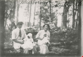
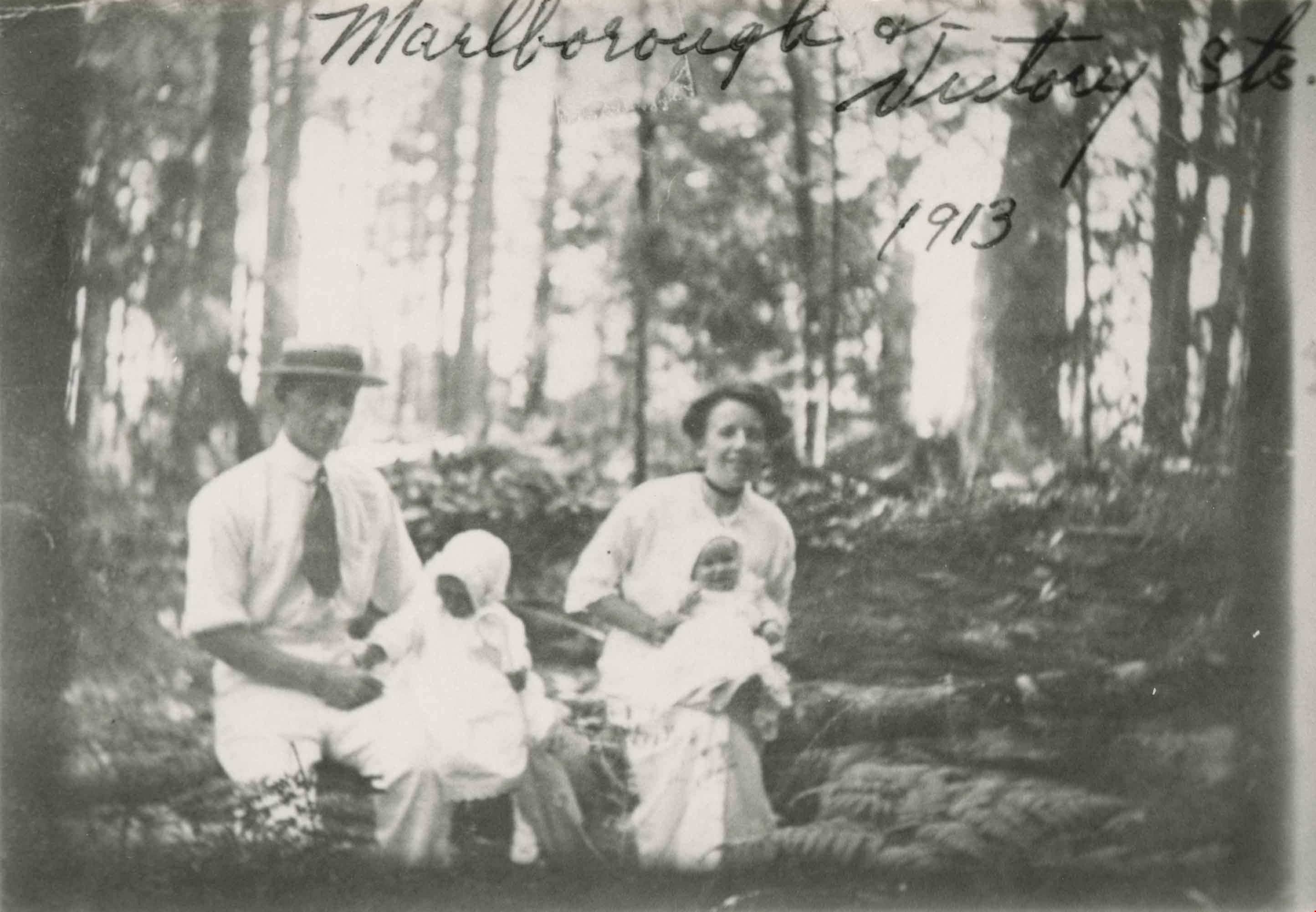
Family at Marlborough Avenue
https://search.heritageburnaby.ca/link/archivedescription35052
- Repository
- City of Burnaby Archives
- Date
- 1913 (date of original), copied 1986
- Collection/Fonds
- Burnaby Historical Society fonds
- Description Level
- Item
- Physical Description
- 1 photograph : b&w ; 8.7 x 12.7 cm print
- Scope and Content
- Photograph of an unidentified family at Marlborough Avenue and Victory Street. A man and woman are seated outside in a forested area holding two small children. An annotation at the top of photograph reads, "Marlborough & Victory Sts. 1913."
- Repository
- City of Burnaby Archives
- Date
- 1913 (date of original), copied 1986
- Collection/Fonds
- Burnaby Historical Society fonds
- Subseries
- Gough family subseries
- Physical Description
- 1 photograph : b&w ; 8.7 x 12.7 cm print
- Description Level
- Item
- Record No.
- 182-006
- Access Restriction
- No restrictions
- Reproduction Restriction
- No known restrictions
- Accession Number
- BHS1986-30
- Scope and Content
- Photograph of an unidentified family at Marlborough Avenue and Victory Street. A man and woman are seated outside in a forested area holding two small children. An annotation at the top of photograph reads, "Marlborough & Victory Sts. 1913."
- Subjects
- Geographic Features - Forests
- Media Type
- Photograph
- Notes
- Title based on contents of photograph
- Geographic Access
- Marlborough Avenue
- Victory Street
- Historic Neighbourhood
- Alta-Vista (Historic Neighbourhood)
- Planning Study Area
- Sussex-Nelson Area
Images
![Family gathering, [191-?] (date of original), copied 1991 thumbnail](/media/hpo/_Data/_Archives_Images/_Unrestricted/370/370-678.jpg?width=280)
Family gathering
https://search.heritageburnaby.ca/link/archivedescription38091
- Repository
- City of Burnaby Archives
- Date
- [191-?] (date of original), copied 1991
- Collection/Fonds
- Burnaby Historical Society fonds
- Description Level
- Item
- Physical Description
- 1 photograph : b&w ; 2.7 x 4.8 cm print on contact sheet 21.5 x 26.8 cm
- Scope and Content
- Photograph of a family gathering at house on Rumble Street. People are standing on the porch and stairs of the house.
- Repository
- City of Burnaby Archives
- Date
- [191-?] (date of original), copied 1991
- Collection/Fonds
- Burnaby Historical Society fonds
- Subseries
- Burnaby Image Bank subseries
- Physical Description
- 1 photograph : b&w ; 2.7 x 4.8 cm print on contact sheet 21.5 x 26.8 cm
- Description Level
- Item
- Record No.
- 370-678
- Access Restriction
- No restrictions
- Reproduction Restriction
- No restrictions
- Accession Number
- BHS1999-03
- Scope and Content
- Photograph of a family gathering at house on Rumble Street. People are standing on the porch and stairs of the house.
- Media Type
- Photograph
- Notes
- Title based on contents of photograph
- 1 b&w copy negative accompanying
- Negative has a pink cast
- Geographic Access
- Rumble Street
- Historic Neighbourhood
- Alta-Vista (Historic Neighbourhood)
- Planning Study Area
- Sussex-Nelson Area
Images
![Family gathering, [191-?] (date of original), copied 1991 thumbnail](/media/hpo/_Data/_Archives_Images/_Unrestricted/370/370-678.jpg)
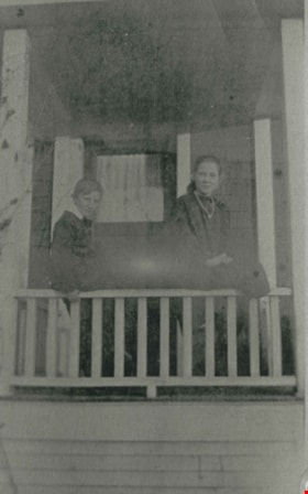
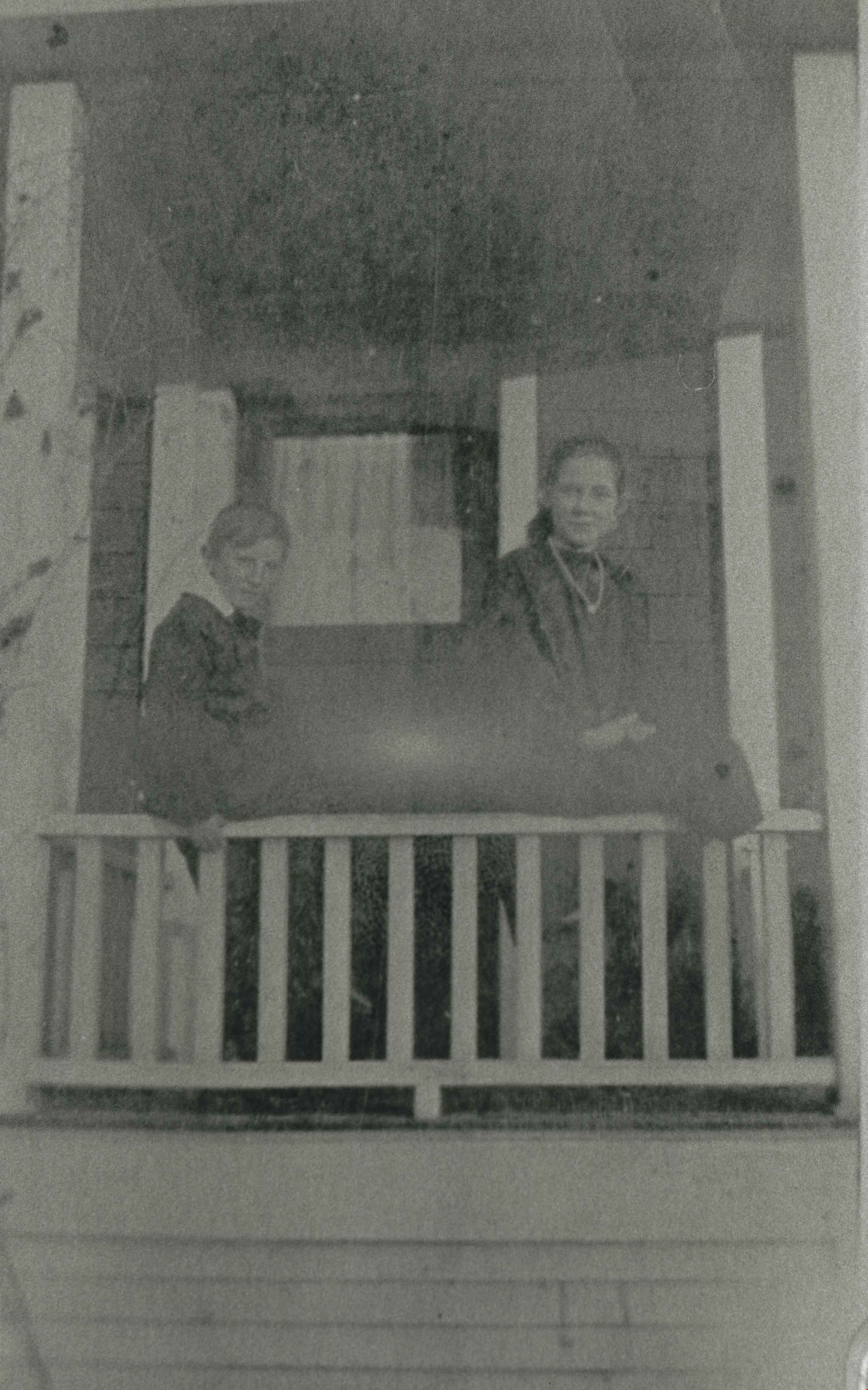
Gough children
https://search.heritageburnaby.ca/link/archivedescription35489
- Repository
- City of Burnaby Archives
- Date
- 1916 (date of original), copied 1986
- Collection/Fonds
- Burnaby Historical Society fonds
- Description Level
- Item
- Physical Description
- 1 photograph : b&w ; 12.7 x 17.8 cm print
- Scope and Content
- Photograph of (left) Leslie Gough and (right) Phyllis Gough, children of William and Agnes Gough, on the porch of of 2119 Nelson Avenue (later 7126 Nelson Avenue).
- Repository
- City of Burnaby Archives
- Date
- 1916 (date of original), copied 1986
- Collection/Fonds
- Burnaby Historical Society fonds
- Subseries
- Pioneer Tales subseries
- Physical Description
- 1 photograph : b&w ; 12.7 x 17.8 cm print
- Description Level
- Item
- Record No.
- 204-347
- Access Restriction
- No restrictions
- Reproduction Restriction
- No known restrictions
- Accession Number
- BHS1988-03
- Scope and Content
- Photograph of (left) Leslie Gough and (right) Phyllis Gough, children of William and Agnes Gough, on the porch of of 2119 Nelson Avenue (later 7126 Nelson Avenue).
- Names
- Gough, Leslie
- Gough, Phyllis
- Media Type
- Photograph
- Notes
- Title based on contents of photograph
- Geographic Access
- Nelson Avenue
- Street Address
- 7126 Nelson Avenue
- Historic Neighbourhood
- Alta-Vista (Historic Neighbourhood)
- Planning Study Area
- Sussex-Nelson Area
Images
![Gough family, [1916] (date of original), copied 1986 thumbnail](/media/hpo/_Data/_Archives_Images/_Unrestricted/204/204-017.jpg?width=280)
Gough family
https://search.heritageburnaby.ca/link/archivedescription35160
- Repository
- City of Burnaby Archives
- Date
- [1916] (date of original), copied 1986
- Collection/Fonds
- Burnaby Historical Society fonds
- Description Level
- Item
- Physical Description
- 1 photograph : b&w ; 12.7 x 17.8 cm print
- Scope and Content
- Photograph of the Gough family children in front of their Nelson Avenue home. Left to right: Dorothy Gough Love, Phyllis Gough and Donald Gough. The address on Nelson Avenue was later changed from 2119 to 7126.
- Repository
- City of Burnaby Archives
- Date
- [1916] (date of original), copied 1986
- Collection/Fonds
- Burnaby Historical Society fonds
- Subseries
- Pioneer Tales subseries
- Physical Description
- 1 photograph : b&w ; 12.7 x 17.8 cm print
- Description Level
- Item
- Record No.
- 204-017
- Access Restriction
- No restrictions
- Reproduction Restriction
- No known restrictions
- Accession Number
- BHS1988-03
- Scope and Content
- Photograph of the Gough family children in front of their Nelson Avenue home. Left to right: Dorothy Gough Love, Phyllis Gough and Donald Gough. The address on Nelson Avenue was later changed from 2119 to 7126.
- Media Type
- Photograph
- Notes
- Title based on contents of photograph
- Geographic Access
- Nelson Avenue
- Street Address
- 7126 Nelson Avenue
- Historic Neighbourhood
- Alta-Vista (Historic Neighbourhood)
- Planning Study Area
- Sussex-Nelson Area
Images
![Gough family, [1916] (date of original), copied 1986 thumbnail](/media/hpo/_Data/_Archives_Images/_Unrestricted/204/204-017.jpg)

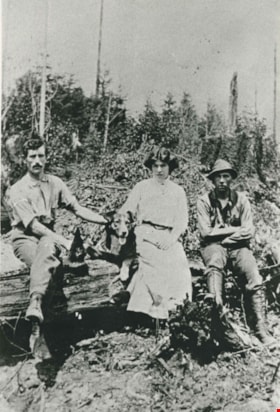
Gray family clearing land
https://search.heritageburnaby.ca/link/archivedescription35520
- Repository
- City of Burnaby Archives
- Date
- 1911 (date of original), copied 1986
- Collection/Fonds
- Burnaby Historical Society fonds
- Description Level
- Item
- Physical Description
- 1 photograph : b&w ; 12.7 x 17.8 cm print
- Scope and Content
- Photograph of the Gray family clearing a lot for the family home at 4375 Winnifred Street. Clamor Gray (father of William Gray) and Ernie North (uncle, right), both carpenters, built this house and others for relatives nearby.
- Repository
- City of Burnaby Archives
- Date
- 1911 (date of original), copied 1986
- Collection/Fonds
- Burnaby Historical Society fonds
- Subseries
- Pioneer Tales subseries
- Physical Description
- 1 photograph : b&w ; 12.7 x 17.8 cm print
- Description Level
- Item
- Record No.
- 204-378
- Access Restriction
- No restrictions
- Reproduction Restriction
- No known restrictions
- Accession Number
- BHS1988-03
- Scope and Content
- Photograph of the Gray family clearing a lot for the family home at 4375 Winnifred Street. Clamor Gray (father of William Gray) and Ernie North (uncle, right), both carpenters, built this house and others for relatives nearby.
- Subjects
- Land Clearing
- Plants - Trees
- Names
- Gray, Clamor
- Gray, Ernie
- Media Type
- Photograph
- Notes
- Title based on contents of photograph
- Geographic Access
- Winnifred Street
- Street Address
- 4375 Winnifred Street
- Historic Neighbourhood
- Alta-Vista (Historic Neighbourhood)
- Planning Study Area
- Sussex-Nelson Area
Images

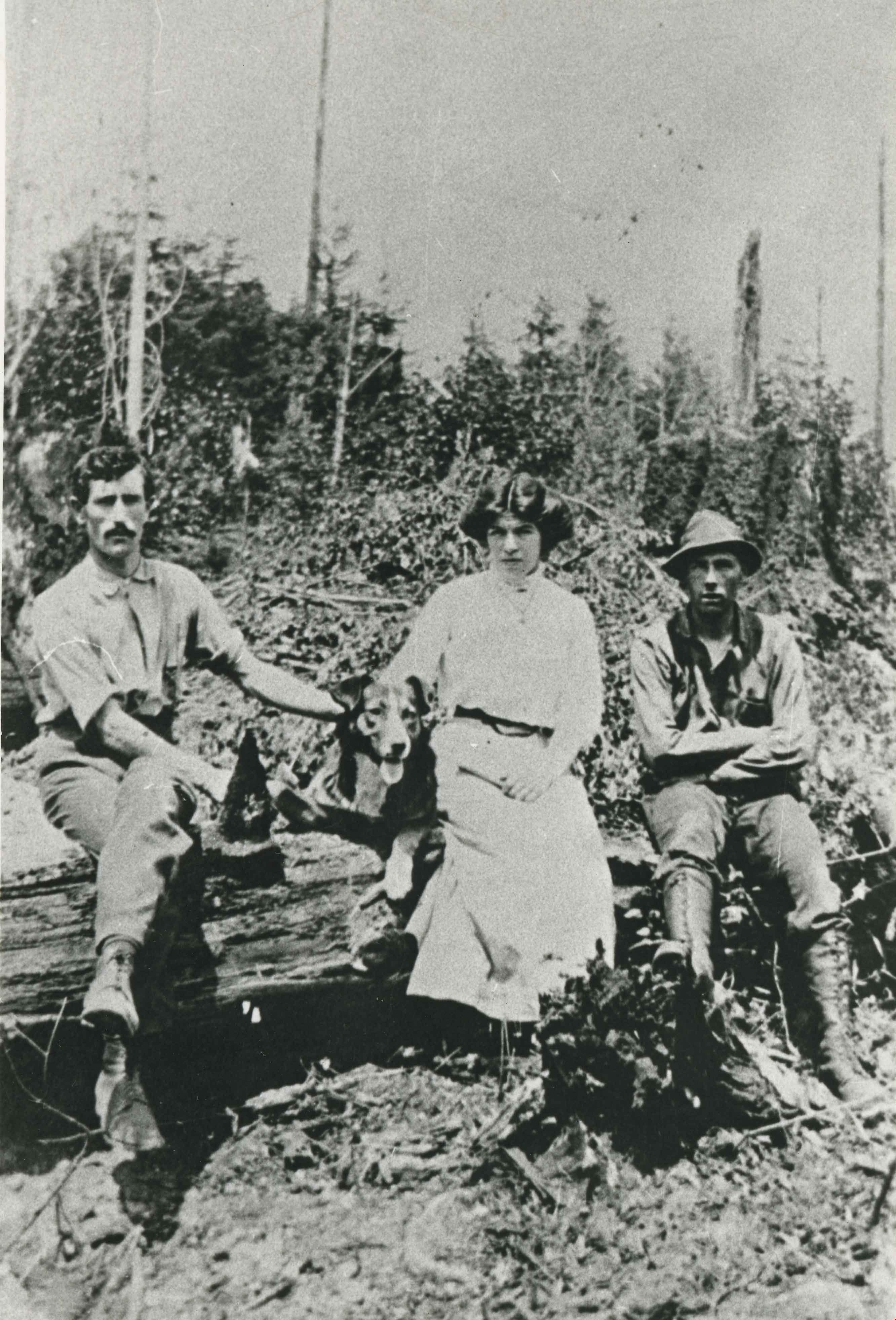
Gray Family Clearing Lot
https://search.heritageburnaby.ca/link/archivedescription35523
- Repository
- City of Burnaby Archives
- Date
- 1911 (date of original), copied 1986
- Collection/Fonds
- Burnaby Historical Society fonds
- Description Level
- Item
- Physical Description
- 1 photograph : b&w ; 12.7 x 17.8 cm print
- Scope and Content
- Photograph of the Gray family clearing the lot for their family home at 4375 Winnifred Street. (From left) Clamor Gray (father of William Gray) Emily Gray (mother), and Ernie North (uncle by marriage; he had married Hilda, the sister of Clamor Gray).
- Repository
- City of Burnaby Archives
- Date
- 1911 (date of original), copied 1986
- Collection/Fonds
- Burnaby Historical Society fonds
- Subseries
- Pioneer Tales subseries
- Physical Description
- 1 photograph : b&w ; 12.7 x 17.8 cm print
- Description Level
- Item
- Record No.
- 204-381
- Access Restriction
- No restrictions
- Reproduction Restriction
- No known restrictions
- Accession Number
- BHS1988-03
- Scope and Content
- Photograph of the Gray family clearing the lot for their family home at 4375 Winnifred Street. (From left) Clamor Gray (father of William Gray) Emily Gray (mother), and Ernie North (uncle by marriage; he had married Hilda, the sister of Clamor Gray).
- Subjects
- Animals - Dogs
- Land Clearing
- Media Type
- Photograph
- Notes
- Title based on contents of photograph
- Geographic Access
- Winnifred Street
- Street Address
- 4375 Winnifred Street
- Historic Neighbourhood
- Alta-Vista (Historic Neighbourhood)
- Planning Study Area
- Sussex-Nelson Area
Images
![Gray family tent, [1911] (date of original), copied 1986 thumbnail](/media/hpo/_Data/_Archives_Images/_Unrestricted/204/204-377.jpg?width=280)
Gray family tent
https://search.heritageburnaby.ca/link/archivedescription35519
- Repository
- City of Burnaby Archives
- Date
- [1911] (date of original), copied 1986
- Collection/Fonds
- Burnaby Historical Society fonds
- Description Level
- Item
- Physical Description
- 1 photograph : b&w ; 12.7 x 17.8 cm print
- Scope and Content
- Photograph of the Gray family tent on their 4375 Winnifred Street property. (Inside tent) Clamor Gray (father of William Gray). The Grays lived in the tent while their house was being built by Mr. Gray, a carpenter.
- Repository
- City of Burnaby Archives
- Date
- [1911] (date of original), copied 1986
- Collection/Fonds
- Burnaby Historical Society fonds
- Subseries
- Pioneer Tales subseries
- Physical Description
- 1 photograph : b&w ; 12.7 x 17.8 cm print
- Description Level
- Item
- Record No.
- 204-377
- Access Restriction
- No restrictions
- Reproduction Restriction
- No known restrictions
- Accession Number
- BHS1988-03
- Scope and Content
- Photograph of the Gray family tent on their 4375 Winnifred Street property. (Inside tent) Clamor Gray (father of William Gray). The Grays lived in the tent while their house was being built by Mr. Gray, a carpenter.
- Subjects
- Land Clearing
- Structures - Tents
- Names
- Gray, Clamor
- Media Type
- Photograph
- Notes
- Title based on contents of photograph
- Geographic Access
- Winnifred Street
- Street Address
- 4375 Winnifred Street
- Historic Neighbourhood
- Alta-Vista (Historic Neighbourhood)
- Planning Study Area
- Sussex-Nelson Area
Images
![Gray family tent, [1911] (date of original), copied 1986 thumbnail](/media/hpo/_Data/_Archives_Images/_Unrestricted/204/204-377.jpg)

Homes near Keith and McGregor
https://search.heritageburnaby.ca/link/archivedescription79946
- Repository
- City of Burnaby Archives
- Date
- September 16, 1976
- Collection/Fonds
- Burnaby Public Library Contemporary Visual Archive Project
- Description Level
- Item
- Physical Description
- 1 photograph : b&w ; 11 x 16 cm mounted on cardboard
- Scope and Content
- Photograph shows a view of backyards of houses near Keith Street and McGregor Avenue with the flats south of Marine Drive in the background.
- Repository
- City of Burnaby Archives
- Date
- September 16, 1976
- Collection/Fonds
- Burnaby Public Library Contemporary Visual Archive Project
- Physical Description
- 1 photograph : b&w ; 11 x 16 cm mounted on cardboard
- Description Level
- Item
- Record No.
- 556-517
- Access Restriction
- No restrictions
- Reproduction Restriction
- Reproduce for fair dealing purposes only
- Accession Number
- 2013-13
- Scope and Content
- Photograph shows a view of backyards of houses near Keith Street and McGregor Avenue with the flats south of Marine Drive in the background.
- Subjects
- Aerial Photographs
- Media Type
- Photograph
- Photographer
- Ross, Martha
- Notes
- Scope note taken directly from BPL photograph description.
- 1 b&w copy negative : 10 x 12.5 cm accompanying
- Geographic Access
- McGregor Avenue
- Keith Street
- Historic Neighbourhood
- Alta-Vista (Historic Neighbourhood)
- Planning Study Area
- Sussex-Nelson Area
Images


House at 5135 Ewart Street
https://search.heritageburnaby.ca/link/archivedescription78922
- Repository
- City of Burnaby Archives
- Date
- September 16, 1976
- Collection/Fonds
- Burnaby Public Library Contemporary Visual Archive Project
- Description Level
- Item
- Physical Description
- 1 photograph : b&w ; 11 x 16 cm mounted on cardboard
- Scope and Content
- Photograph shows a house at 5135 Ewart Street near Royal Oak Avenue built in approximately 1916 by Danny Ewart, an Oakalla prison guard. Ewart Street was named after him.
- Repository
- City of Burnaby Archives
- Date
- September 16, 1976
- Collection/Fonds
- Burnaby Public Library Contemporary Visual Archive Project
- Physical Description
- 1 photograph : b&w ; 11 x 16 cm mounted on cardboard
- Description Level
- Item
- Record No.
- 556-036
- Access Restriction
- No restrictions
- Reproduction Restriction
- Reproduce for fair dealing purposes only
- Accession Number
- 2013-13
- Scope and Content
- Photograph shows a house at 5135 Ewart Street near Royal Oak Avenue built in approximately 1916 by Danny Ewart, an Oakalla prison guard. Ewart Street was named after him.
- Media Type
- Photograph
- Photographer
- Ross, Martha
- Notes
- Scope note taken directly from BPL photograph description.
- 1 b&w copy negative : 10 x 12.5 cm accompanying
- Geographic Access
- Ewart Street
- Street Address
- 5135 Ewart Street
- Historic Neighbourhood
- Alta-Vista (Historic Neighbourhood)
- Planning Study Area
- Sussex-Nelson Area
Images