Narrow Results By
Person / Organization
- Coe, Patsy Speirs 1
- Digney, Andy 4
- Digney, Ernest Frank "Dig" 1
- Elizabeth, Queen, consort of George VI, King of Great Britain, 1900-2002 1
- Ellis, Jim 1
- Elllis, Jim 1
- Fowler, Rod 2
- George VI, King of Great Britain, 1895-1952 1
- Kantonen, Terttu Ullriki "Bertha" 1
- Le Grove, Evelyn Hardy 1
- Lewarne, Ethel Leer 1
- Lewarne, William A. "Bill" 2
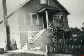
Rorison family home
https://search.heritageburnaby.ca/link/archivedescription35379
- Repository
- City of Burnaby Archives
- Date
- 1930 (date of original), copied 1986
- Collection/Fonds
- Burnaby Historical Society fonds
- Description Level
- Item
- Physical Description
- 1 photograph : b&w ; 12.7 x 17.8 cm print
- Scope and Content
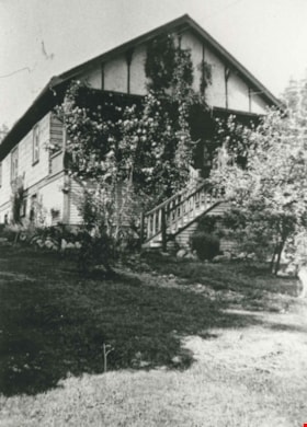
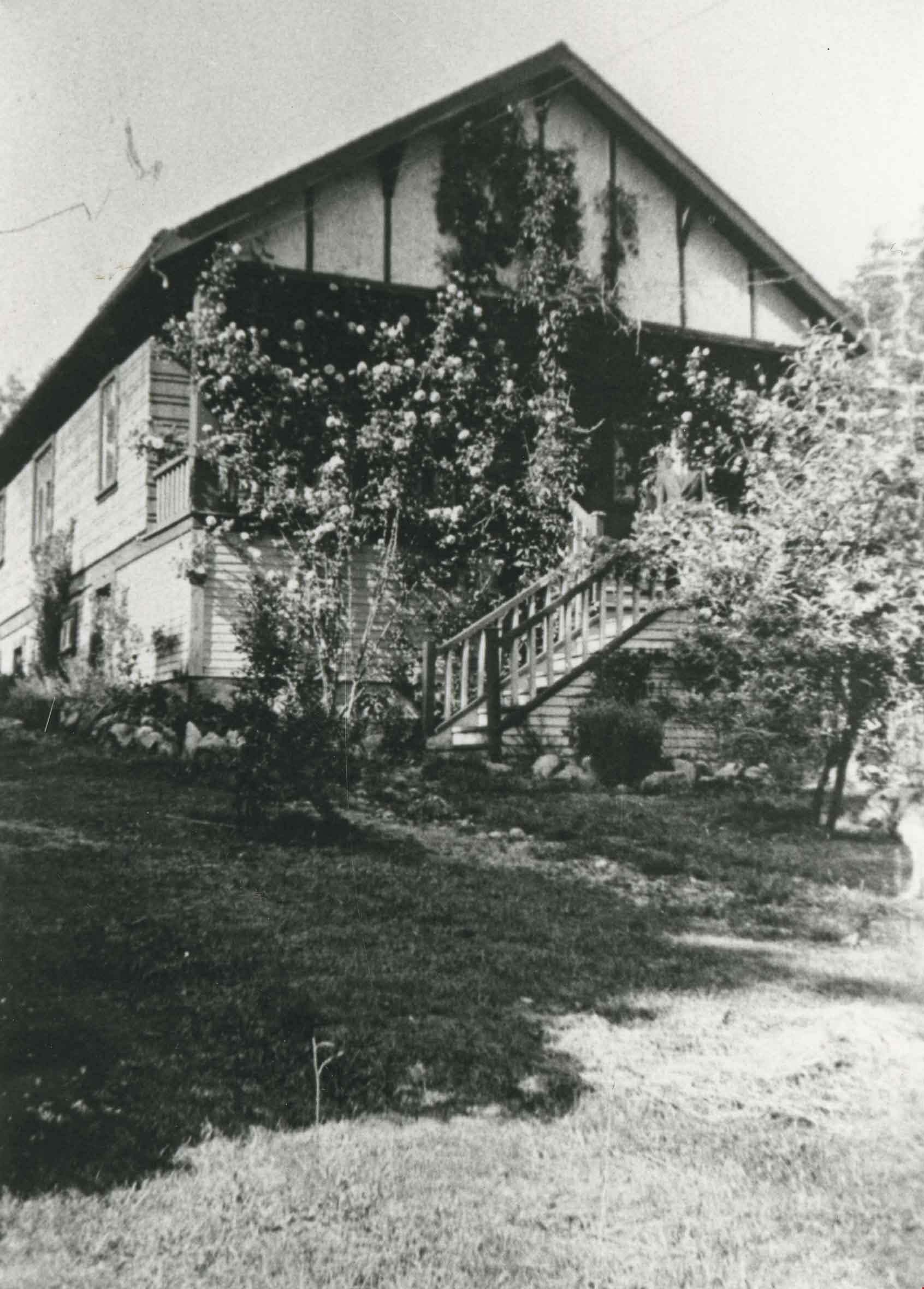
- Photograph of the William Rorison family home at 3907 River Road (later becoming 4593 Marine Drive at Strathern Avenue) in the South Slope area. William Rorison built this house next to another for his mother-in-law. The Rorison family consisted of William Rorison, his wife Alma Rorison (nee Cropl…
- Repository
- City of Burnaby Archives
- Date
- 1930 (date of original), copied 1986
- Collection/Fonds
- Burnaby Historical Society fonds
- Subseries
- Pioneer Tales subseries
- Physical Description
- 1 photograph : b&w ; 12.7 x 17.8 cm print
- Description Level
- Item
- Record No.
- 204-236
- Access Restriction
- No restrictions
- Reproduction Restriction
- No known restrictions
- Accession Number
- BHS1988-03
- Scope and Content
- Photograph of the William Rorison family home at 3907 River Road (later becoming 4593 Marine Drive at Strathern Avenue) in the South Slope area. William Rorison built this house next to another for his mother-in-law. The Rorison family consisted of William Rorison, his wife Alma Rorison (nee Cropley) and their children: Kay (later Kay North), Evelyn, Bill, Hugh, and John.
- Subjects
- Buildings - Residential - Houses
- Media Type
- Photograph
- Notes
- Title based on contents of photograph
- Geographic Access
- Marine Drive
- Street Address
- 4593 Marine Drive
- Historic Neighbourhood
- Fraser Arm (Historic Neighbourhood)
- Planning Study Area
- Sussex-Nelson Area
Images
Royal Visit
https://search.heritageburnaby.ca/link/archivedescription85203
- Repository
- City of Burnaby Archives
- Date
- 1939
- Collection/Fonds
- Digney Family fonds
- Description Level
- Item
- Physical Description
- 1 film clip (1 min., 52 sec.) : digital, col., si.
- Scope and Content
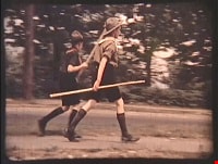
- Item is a digitized copy of a silent colour film segment with footage of the Royal Visit from King George VI and Queen consort, Elizabeth. Boy Scouts and members of the community can be seen preparing for a roadside view of the motorcade and Mr. Digney can be seen pacing in his gardens at the Oak T…
- Repository
- City of Burnaby Archives
- Date
- 1939
- Collection/Fonds
- Digney Family fonds
- Physical Description
- 1 film clip (1 min., 52 sec.) : digital, col., si.
- Description Level
- Item
- Record No.
- 562-002-2
- Access Restriction
- No restrictions
- Reproduction Restriction
- No known restrictions
- Accession Number
- 2012-15
- Scope and Content
- Item is a digitized copy of a silent colour film segment with footage of the Royal Visit from King George VI and Queen consort, Elizabeth. Boy Scouts and members of the community can be seen preparing for a roadside view of the motorcade and Mr. Digney can be seen pacing in his gardens at the Oak Theatre. As the royal couple (King George VI and Queen Elizabeth) drive by the crowd on Kingsway, they can be seen in a automobile identified as a McLaughlin model 45 Extra Special series, with Queen Elizabeth holding a white umbrella. RCMP officers are seen on a motorcycle with a side car, while dignitaries and officials in automobiles accompany the royal couple as the crowd waves red flags and looks on as the cars drive off.
- Subjects
- Events - May Day
- Events - Royal Visits
- Buildings - Commercial - Theatres
- Recreational Activities - Theatre
- Names
- Oak Theatre
- Digney, Andy
- Elizabeth, Queen, consort of George VI, King of Great Britain, 1900-2002
- George VI, King of Great Britain, 1895-1952
- Media Type
- Moving Images
- Photographer
- Digney, Andy
- Creator
- Digney, Andy
- Notes
- Title based on contents of film
- Film clip originates from digitized version of original 16 mm film footage (item 562-002). This segment was part of digitized portion titled 'Royal Visit'
- Geographic Access
- Kingsway
- Central Park
- Historic Neighbourhood
- Central Park (Historic Neighbourhood)
- Planning Study Area
- Sussex-Nelson Area
Images

Video
Royal Visit, 1939
![Rumble Road, [1930] thumbnail](/media/hpo/_Data/_Archives_Images/_Unrestricted/204/204-022.jpg?width=280)
Rumble Road
https://search.heritageburnaby.ca/link/archivedescription35165
- Repository
- City of Burnaby Archives
- Date
- [1930]
- Collection/Fonds
- Burnaby Historical Society fonds
- Description Level
- Item
- Physical Description
- 1 photograph : b&w ; 12.7 x 17.8 cm
- Scope and Content
- Photograph of Rumble Road east of Patterson.
- Repository
- City of Burnaby Archives
- Date
- [1930]
- Collection/Fonds
- Burnaby Historical Society fonds
- Subseries
- Pioneer Tales subseries
- Physical Description
- 1 photograph : b&w ; 12.7 x 17.8 cm
- Description Level
- Item
- Record No.
- 204-022
- Access Restriction
- No restrictions
- Reproduction Restriction
- No known restrictions
- Accession Number
- BHS1988-03
- Scope and Content
- Photograph of Rumble Road east of Patterson.
- Subjects
- Geographic Features - Roads
- Media Type
- Photograph
- Photographer
- Stone, Gene
- Notes
- Title based on contents of photograph
- Geographic Access
- Rumble Street
- Patterson Avenue
- Historic Neighbourhood
- Alta-Vista (Historic Neighbourhood)
- Planning Study Area
- Sussex-Nelson Area
Images
![Rumble Road, [1930] thumbnail](/media/hpo/_Data/_Archives_Images/_Unrestricted/204/204-022.jpg)

Rumble Street
https://search.heritageburnaby.ca/link/archivedescription34255
- Repository
- City of Burnaby Archives
- Date
- 1932
- Collection/Fonds
- Burnaby Historical Society fonds
- Description Level
- Item
- Physical Description
- 1 photograph : b&w ; 12.2 x 17.7 cm
- Scope and Content
- Photograph of Rumble Street looking east toward Patterson Avenue, located where the house on the left can be seen.
- Repository
- City of Burnaby Archives
- Date
- 1932
- Collection/Fonds
- Burnaby Historical Society fonds
- Subseries
- Photographs subseries
- Physical Description
- 1 photograph : b&w ; 12.2 x 17.7 cm
- Description Level
- Item
- Record No.
- 011-002
- Access Restriction
- No restrictions
- Reproduction Restriction
- No known restrictions
- Accession Number
- BHS2007-04
- Scope and Content
- Photograph of Rumble Street looking east toward Patterson Avenue, located where the house on the left can be seen.
- Media Type
- Photograph
- Notes
- Title based on contents of photograph
- Annotation at bottom of Copy 2 reads, "Rumble St. just after Municipal dump was filled / Facing east house on left is where Patterson Avenue [is]"
- Geographic Access
- Rumble Street
- Patterson Avenue
- Historic Neighbourhood
- Alta-Vista (Historic Neighbourhood)
- Planning Study Area
- Sussex-Nelson Area
- Suncrest Area
Images

Speirs family home
https://search.heritageburnaby.ca/link/archivedescription35324
- Repository
- City of Burnaby Archives
- Date
- 1930 (date of original), copied 1986
- Collection/Fonds
- Burnaby Historical Society fonds
- Description Level
- Item
- Physical Description
- 1 photograph : b&w ; 12.7 x 17.8 cm print
- Scope and Content
- Photograph of Dell Speirs in front of the Speirs family home on Watling Street (near Frederick Avenue). Dell was the wife of Bill Speirs.
- Repository
- City of Burnaby Archives
- Date
- 1930 (date of original), copied 1986
- Collection/Fonds
- Burnaby Historical Society fonds
- Subseries
- Pioneer Tales subseries
- Physical Description
- 1 photograph : b&w ; 12.7 x 17.8 cm print
- Description Level
- Item
- Record No.
- 204-181
- Access Restriction
- No restrictions
- Reproduction Restriction
- No known restrictions
- Accession Number
- BHS1988-03
- Scope and Content
- Photograph of Dell Speirs in front of the Speirs family home on Watling Street (near Frederick Avenue). Dell was the wife of Bill Speirs.
- Subjects
- Buildings - Residential - Houses
- Names
- Speirs, Dell
- Media Type
- Photograph
- Notes
- Title based on contents of photograph
- Geographic Access
- Watling Street
- Historic Neighbourhood
- Alta-Vista (Historic Neighbourhood)
- Planning Study Area
- Sussex-Nelson Area
Images


Trafalgar Market
https://search.heritageburnaby.ca/link/archivedescription98665
- Repository
- City of Burnaby Archives
- Date
- 2022
- Collection/Fonds
- Disappearing Burnaby collection
- Description Level
- Item
- Physical Description
- 1 photograph (jpeg) : col.
- Scope and Content
- Photograph of the intersection of Imperial Street and Sussex Avenue at night and in the rain. The photograph shows the Trafalgar Market grocery store (located at 4398 Imperial Street; the building was constructed in 1940) on the corner, with a large display of flowers for sale under the awning in f…
- Repository
- City of Burnaby Archives
- Date
- 2022
- Collection/Fonds
- Disappearing Burnaby collection
- Physical Description
- 1 photograph (jpeg) : col.
- Description Level
- Item
- Record No.
- 634-012
- Access Restriction
- No restrictions
- Reproduction Restriction
- No restrictions
- Accession Number
- 2022-14
- Scope and Content
- Photograph of the intersection of Imperial Street and Sussex Avenue at night and in the rain. The photograph shows the Trafalgar Market grocery store (located at 4398 Imperial Street; the building was constructed in 1940) on the corner, with a large display of flowers for sale under the awning in front of the store. The street and traffic lights are reflected in the puddles on the road, and cars and other businesses are visible along Imperial Street.
- Subjects
- Buildings - Commercial
- Buildings - Commercial - Grocery Stores
- Buildings - Commercial - Stores
- Geographic Features - Roads
- Media Type
- Photograph
- Photographer
- Cheung, Nakita
- Notes
- Title taken from the associated blog post
- Associated blog post: https://disappearingburnaby.wordpress.com/2022/02/20/imperial-manor-2/
- Geographic Access
- Imperial Street
- Sussex Avenue
- Street Address
- 4398 Imperial Street
- Historic Neighbourhood
- Central Park (Historic Neighbourhood)
- Planning Study Area
- Sussex-Nelson Area
Images

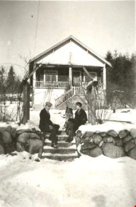
William and Alma Rorison
https://search.heritageburnaby.ca/link/archivedescription53959
- Repository
- City of Burnaby Archives
- Date
- 1937
- Collection/Fonds
- Burnaby Historical Society fonds
- Description Level
- Item
- Physical Description
- 1 photograph : b&w copy negative ; 35 mm
- Scope and Content
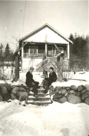
- Photograph of William and Alma Cropley Rorison and their dog Buster sitting on the steps of their front walk in the snow.
- Repository
- City of Burnaby Archives
- Date
- 1937
- Collection/Fonds
- Burnaby Historical Society fonds
- Subseries
- Kay North subseries
- Physical Description
- 1 photograph : b&w copy negative ; 35 mm
- Description Level
- Item
- Record No.
- 269-006
- Access Restriction
- No restrictions
- Reproduction Restriction
- No known restrictions
- Accession Number
- BHS1991-38
- Scope and Content
- Photograph of William and Alma Cropley Rorison and their dog Buster sitting on the steps of their front walk in the snow.
- Media Type
- Photograph
- Notes
- Title based on contents of photograph
- Geographic Access
- Marine Drive
- Street Address
- 4593 Marine Drive
- Historic Neighbourhood
- Fraser Arm (Historic Neighbourhood)
- Planning Study Area
- Sussex-Nelson Area
Images