Narrow Results By
Person / Organization
- Coe, Patsy Speirs 1
- Digney, Andy 4
- Digney, Ernest Frank "Dig" 1
- Elizabeth, Queen, consort of George VI, King of Great Britain, 1900-2002 1
- Ellis, Jim 1
- Elllis, Jim 1
- Fowler, Rod 2
- George VI, King of Great Britain, 1895-1952 1
- Kantonen, Terttu Ullriki "Bertha" 1
- Le Grove, Evelyn Hardy 1
- Lewarne, Ethel Leer 1
- Lewarne, William A. "Bill" 2

Alta Vista Neighbourhood
https://search.heritageburnaby.ca/link/landmark707
- Repository
- Burnaby Heritage Planning
- Associated Dates
- 1925-1954
- Heritage Value
- As with many areas of Burnaby during this period, the years after World War Two marked a rapid growth in residential development in the Alta-Vista Neighbourhood. Subdivisions like Sussex and Suncrest were built and new schools and amenities were constructed to meet the demands of increased population.
- Historic Neighbourhood
- Alta Vista (Historic Neighbourhood)
- Planning Study Area
- Sussex-Nelson Area
Images


Alta Vista Neighbourhood
https://search.heritageburnaby.ca/link/landmark766
- Repository
- Burnaby Heritage Planning
- Associated Dates
- 1905-1924
- Heritage Value
- Alta Vista, named for its high views of the Fraser Valley, rapidly grew during the period 1910-1912, seeing its settlement jump from about a dozen buildings in 1910 to about four hundred by the end of 1912. Home-seekers were attracted to its location just a short walk from the B.C.E.R. line at Royal Oak and Highland Park and easily accessible to both New Westminster and Vancouver.
- Historic Neighbourhood
- Alta Vista (Historic Neighbourhood)
- Planning Study Area
- Sussex-Nelson Area
Images

![Burnaby Alderman, Bill (William) Lewarne, [1973]. Item no. 231-012 thumbnail](/media/hpo/_Data/_Archives_Images/_Unrestricted/205/231-012.jpg?width=280)
Interview with William A. Lewarne by Rod Fowler March 14, 1990 - Track 2
https://search.heritageburnaby.ca/link/oralhistory442
- Repository
- City of Burnaby Archives
- Date Range
- 1893-1944
- Length
- 00:05:35
- Summary
- This portion of the interview is about Bill Lewarne’s parents’ history (Ethel Leer and Alfred Lewarne) and growing up in South Burnaby.
- Repository
- City of Burnaby Archives
- Summary
- This portion of the interview is about Bill Lewarne’s parents’ history (Ethel Leer and Alfred Lewarne) and growing up in South Burnaby.
- Date Range
- 1893-1944
- Photo Info
- Burnaby Alderman, Bill (William) Lewarne, [1973]. Item no. 231-012
- Length
- 00:05:35
- Names
- Lewarne, Ethel Leer
- Historic Neighbourhood
- Alta-Vista (Historic Neighbourhood)
- Planning Study Area
- Sussex-Nelson Area
- Interviewer
- Fowler, Rod
- Interview Date
- March 14, 1990
- Scope and Content
- Recording is of an interview with former Mayor William “Bill” Lewarne, conducted by Rod Fowler. Bill Lewarne was one of eleven participants interviewed as part of the SFU/Burnaby Centennial Committee's oral history series titled, "Voices of Burnaby". The interview is mainly about Bill Lewarne’s business and political careers, and memories of growing up in South Burnaby in the 1930s. Bill Lewarne talks about his parent’s origins, his family and community struggles during the Depression, the interurban, his education, war service, and joining his father's business. He describes the start, operation and expansion of the family ice cream business, and how business life compared to political life. The interview explores the role of politics in community affairs, his political activities, the history of the BVA, and his involvement in various community organizations. To view “Narrow By” terms for each track, expand this description and see “Notes”.
- Biographical Notes
- William Alfred “Bill” Lewarne was born in Burnaby in 1926 to Ethel Cecilia Leer (1899- ) and Alfred Lewarne (1893-1962). The family, Ethel, Alfred and their three children Patricia, Beverley and William, moved to a house on Nelson Avenue in Alta Vista in 1931. Ethel still lived in the family home in 1990. Bill Lewarne attended Nelson Avenue School and South Burnaby High School (1932-1944). His father Alfred worked at Colony Farms as a dairy inspector and then for the Port of Vancouver Dairy before being laid off early in the Depression. The family struggled until in 1936 Alfred started his own ice cream business. After graduation Bill was in the army for two years, taking a refrigeration course under the veteran’s training benefit, before joining his father’s business. Three generations of the family operated the successful company, expanding from wholesale, retail and distribution of ice cream products into refrigerated warehouses and the wholesale ice business, until the business was sold to its competitor Dairyland in 1989. Bill Lewarne entered politics in 1965, first with the Nonpartisan Association (NPA) and then as a founder of the Burnaby Citizens Association (BCA). He served as an alderman on Burnaby Council 1973-1975 and 1977-1981 and as Mayor 1981-1987. In 1979 he ran for provincial office for the Social Credit Party against Rosemary Brown but lost. Bill Lewarne married June Lawrence and they had three children Robert, Leslie and Janice. He was active in many organizations: Burnaby/Willingdon Liberal Association, Seton Villa, Irish Fusileers of Canada, Lions Club, Rotary Club, Burnaby Association for Community Inclusion, and the Burnaby Hospital Foundation, and continued to be active on the Board of the BCA. Bill Lewarne died in 1995.
- Total Tracks
- 14
- Total Length
- 1:34:40
- Interviewee Name
- Lewarne, William A. "Bill"
- Interviewer Bio
- Rod Fowler returned to university as a mature student in the 1980s after working about twenty years in the field of economics and business computerization in England, Europe and Western Canada. He graduated with a BA from SFU in both History and Sociology in 1987, his MA degree in Geography in 1989, and his PhD in Cultural Geography at SFU. He taught courses in Geography, Sociology, History and Canadian Studies at several Lower Mainland colleges, before becoming a full time member of the Geography Department at Kwantlen University College.
- Collection/Fonds
- SFU/Burnaby Centennial Committee fonds
- Transcript Available
- Transcript available
- Media Type
- Sound Recording
- Web Notes
- Interviews were digitized in 2015 allowing them to be accessible on Heritage Burnaby. The digitization project was initiated by the Community Heritage Commission with support from City of Burnaby Council.
Images
![Burnaby Alderman, Bill (William) Lewarne, [1973]. Item no. 231-012 thumbnail](/media/hpo/_Data/_Archives_Images/_Unrestricted/205/231-012.jpg)
Audio Tracks
Track two of interview with Bill Lewarne
Track two of interview with Bill Lewarne
https://search.heritageburnaby.ca/media/hpo/_Data/_Archives_Oral_Histories/_Unrestricted/MSS187-019/MSS187-019_Track_2.mp3![O.G. Naud house, [1908] (date of original), copied 1986 thumbnail](/media/hpo/_Data/_Archives_Images/_Unrestricted/126/172-002-001.jpg?width=280)
O.G. Naud house
https://search.heritageburnaby.ca/link/archivedescription35005
- Repository
- City of Burnaby Archives
- Date
- [1908] (date of original), copied 1986
- Collection/Fonds
- Burnaby Historical Society fonds
- Description Level
- Item
- Physical Description
- 1 photograph : b&w ; 8.8 x 12.5 cm print
- Scope and Content
- Photograph is the left side of a three-part panorama (photos 172-002a to 172-002c) of the land beside the house of Onezime G. Naud, 4737 Victory Road (later renamed Victory Street). A garden and a fence with a woman standing beside it can be seen.
- Repository
- City of Burnaby Archives
- Date
- [1908] (date of original), copied 1986
- Collection/Fonds
- Burnaby Historical Society fonds
- Subseries
- O.G. Naud subseries
- Physical Description
- 1 photograph : b&w ; 8.8 x 12.5 cm print
- Description Level
- Item
- Record No.
- 172-002-1
- Access Restriction
- No restrictions
- Reproduction Restriction
- No known restrictions
- Accession Number
- BHS1986-21
- Scope and Content
- Photograph is the left side of a three-part panorama (photos 172-002a to 172-002c) of the land beside the house of Onezime G. Naud, 4737 Victory Road (later renamed Victory Street). A garden and a fence with a woman standing beside it can be seen.
- Subjects
- Buildings - Residential - Houses
- Media Type
- Photograph
- Notes
- Title based on contents of photograph
- b&w ; 5.5 x 24.5 cm photocopy of entire panorama accompanying in accession file
- Geographic Access
- Victory Street
- Street Address
- 4737 Victory Street
- Historic Neighbourhood
- Alta-Vista (Historic Neighbourhood)
- Planning Study Area
- Sussex-Nelson Area
Images
![O.G. Naud house, [1908] (date of original), copied 1986 thumbnail](/media/hpo/_Data/_Archives_Images/_Unrestricted/126/172-002-001.jpg)
![O.G. Naud house, [1908] (date of original), copied 1986 thumbnail](/media/hpo/_Data/_Archives_Images/_Unrestricted/126/172-002-002.jpg?width=280)
O.G. Naud house
https://search.heritageburnaby.ca/link/archivedescription39831
- Repository
- City of Burnaby Archives
- Date
- [1908] (date of original), copied 1986
- Collection/Fonds
- Burnaby Historical Society fonds
- Description Level
- Item
- Physical Description
- 1 photograph : b&w ; 8.8 x 12.5 cm print
- Scope and Content
- Photograph is the centre of a three-part panorama (items no. 172-002a to 172-002c) of the house of Onezime G. Naud at 4737 Victory Road (later renamed Victory Street). A house and garden with a number of adults and children standing outside can be seen.
- Repository
- City of Burnaby Archives
- Date
- [1908] (date of original), copied 1986
- Collection/Fonds
- Burnaby Historical Society fonds
- Subseries
- O.G. Naud subseries
- Physical Description
- 1 photograph : b&w ; 8.8 x 12.5 cm print
- Description Level
- Item
- Record No.
- 172-002-2
- Access Restriction
- No restrictions
- Reproduction Restriction
- No known restrictions
- Accession Number
- BHS1986-21
- Scope and Content
- Photograph is the centre of a three-part panorama (items no. 172-002a to 172-002c) of the house of Onezime G. Naud at 4737 Victory Road (later renamed Victory Street). A house and garden with a number of adults and children standing outside can be seen.
- Subjects
- Buildings - Residential - Houses
- Media Type
- Photograph
- Notes
- Title based on contents of photograph
- b&w ; 5.5 x 24.5 cm photocopy of entire panorama accompanying in accession file
- Annotation on back of photo reads, "O.G. Naud House, Nelson Ave., c. 1910"
- Geographic Access
- Victory Street
- Street Address
- 4737 Victory Street
- Historic Neighbourhood
- Alta-Vista (Historic Neighbourhood)
- Planning Study Area
- Sussex-Nelson Area
Images
![O.G. Naud house, [1908] (date of original), copied 1986 thumbnail](/media/hpo/_Data/_Archives_Images/_Unrestricted/126/172-002-002.jpg)
![O.G. Naud house, [1908] (date of original), copied 1986 thumbnail](/media/hpo/_Data/_Archives_Images/_Unrestricted/126/172-002-003.jpg?width=280)
O.G. Naud house
https://search.heritageburnaby.ca/link/archivedescription39832
- Repository
- City of Burnaby Archives
- Date
- [1908] (date of original), copied 1986
- Collection/Fonds
- Burnaby Historical Society fonds
- Description Level
- Item
- Physical Description
- 1 photograph : b&w ; 8.8 x 12.5 cm print
- Scope and Content
- Photograph is the right side of a three-part panorama (photos 172-002a to 172-002c) showing the land beside the house of Onezime G. Naud at 4737 Victory Road (later renamed Victory Street). A number of adults and children are seen standing in a field.
- Repository
- City of Burnaby Archives
- Date
- [1908] (date of original), copied 1986
- Collection/Fonds
- Burnaby Historical Society fonds
- Subseries
- O.G. Naud subseries
- Physical Description
- 1 photograph : b&w ; 8.8 x 12.5 cm print
- Description Level
- Item
- Record No.
- 172-002-3
- Access Restriction
- No restrictions
- Reproduction Restriction
- No known restrictions
- Accession Number
- BHS1986-21
- Scope and Content
- Photograph is the right side of a three-part panorama (photos 172-002a to 172-002c) showing the land beside the house of Onezime G. Naud at 4737 Victory Road (later renamed Victory Street). A number of adults and children are seen standing in a field.
- Media Type
- Photograph
- Notes
- Title based on contents of photograph
- b&w ; 5.5 x 24.5 cm photocopy of entire panorama accompanying in accession file
- Geographic Access
- Victory Street
- Street Address
- 4737 Victory Street
- Historic Neighbourhood
- Alta-Vista (Historic Neighbourhood)
- Planning Study Area
- Sussex-Nelson Area
Images
![O.G. Naud house, [1908] (date of original), copied 1986 thumbnail](/media/hpo/_Data/_Archives_Images/_Unrestricted/126/172-002-003.jpg)

O.G. Naud House
https://search.heritageburnaby.ca/link/landmark509
- Repository
- Burnaby Heritage Planning
- Description
- The O.G. Naud House is a south facing, two-storey house with a bellcast hipped roof, set on a high basement. It features a double-height front verandah supported by classical columns. It is located on Victory Street in the Alta Vista neighbourhood of South Burnaby, and is one of the oldest houses i…
- Associated Dates
- 1908
- Formal Recognition
- Heritage Designation, Community Heritage Register
- Other Names
- Onezime & Charlsie Naud House
- Street View URL
- Google Maps Street View
- Repository
- Burnaby Heritage Planning
- Other Names
- Onezime & Charlsie Naud House
- Geographic Access
- Victory Street
- Associated Dates
- 1908
- Formal Recognition
- Heritage Designation, Community Heritage Register
- Enactment Type
- By-law No. 12316
- Enactment Date
- 26/05/2008
- Description
- The O.G. Naud House is a south facing, two-storey house with a bellcast hipped roof, set on a high basement. It features a double-height front verandah supported by classical columns. It is located on Victory Street in the Alta Vista neighbourhood of South Burnaby, and is one of the oldest houses in the area.
- Heritage Value
- Built in 1908, the O.G. Naud House is valued as one of the first houses to be built in the Alta Vista neighbourhood and is a direct link to the first settlement of the area. Close proximity to the B.C. Electric Railway streetcar line, at Royal Oak and Highland Park, permitted easy access to New Westminster and Vancouver. These transportation links, combined with spectacular views of the Fraser Valley, encouraged the early development of this South Burnaby neighbourhood. The O.G. Naud House is architecturally significant as an example of the influence of the Classical Revival style that had been popularized in Eastern Canada. The basic form of the house is a Foursquare, with a double-height verandah that dominates the symmetrically balanced façade, supported on lathe-turned columns. A central entry and regular fenestration further unify the façade composition. Construction employed locally available materials. The rough-cut foundation stone was harvested from boulders from the G. Ledingham property on the south side of Victory Street. The builder and first owner, Onezime George Naud (1858-1951), was originally from St. Albans, Quebec. He worked on railway construction in Alabama, where he met his wife, Charlsie Elizabeth Sims (1869-1974). He later took part in the 1898 Gold Rush in Atlin, then worked as a stonemason on CPR culverts and bridges across B.C. An accomplished stonemason, Naud also worked on the original Vancouver and New Westminster post offices, the Parliament buildings in Victoria, and the Capitol building in Olympia, Washington.
- Defining Elements
- The key characteristics that define the heritage character of the O.G. Naud House include its: - south-facing location, with generous set back from the street, in the Alta Vista neighbourhood of South Burnaby - residential form, scale and massing as expressed by its two-storey height plus full basement, bellcast hipped roof, rectangular plan and front projecting double-height verandah - masonry construction materials such as the rough-cut granite foundation - wood-frame construction, including lapped wooden siding and shingle siding extant under later cladding - Edwardian era features including lathe-turned columns, balustrades of dimensional lumber, scroll-cut bargeboards in front gable, and scroll-cut eave brackets - associated landscape features including lane access to the east, large cedar trees and perimeter plantings
- Historic Neighbourhood
- Alta Vista (Historic Neighbourhood)
- Planning Study Area
- Sussex-Nelson Area
- Function
- Primary Historic--Single Dwelling
- Community
- Alta Vista
- Cadastral Identifier
- P.I.D.003-100-375
- Boundaries
- The O.G. Naud House is comprised of a single residential lot located at 4737 Victory Street, Burnaby.
- Area
- 1099.47
- Contributing Resource
- Building
- Ownership
- Private
- Documentation
- City of Burnaby Planning and Building Department, Heritage Site Files
- Street Address
- 4737 Victory Street
- Street View URL
- Google Maps Street View
Images


Interview with William A. Lewarne by Rod Fowler March 14, 1990 - Track 1
https://search.heritageburnaby.ca/link/oralhistory441
- Repository
- City of Burnaby Archives
- Date Range
- 1926-1989
- Length
- 00:10:22
- Summary
- This portion of the interview is mainly about the start of the Lewarne family ice cream business in the Depression and its history under three generations of the family. He also remembers the hard times of the Depression, the schools he attended in South Burnaby, and Mr. Seller’s shetland ponies.
- Repository
- City of Burnaby Archives
- Summary
- This portion of the interview is mainly about the start of the Lewarne family ice cream business in the Depression and its history under three generations of the family. He also remembers the hard times of the Depression, the schools he attended in South Burnaby, and Mr. Seller’s shetland ponies.
- Date Range
- 1926-1989
- Photo Info
- Burnaby Alderman, Bill (William) Lewarne, [1973]. Item no. 231-012
- Length
- 00:10:22
- Subjects
- Occupations - Entrepreneurs
- Business
- Geographic Access
- Nelson Avenue
- Historic Neighbourhood
- Alta-Vista (Historic Neighbourhood)
- Planning Study Area
- Sussex-Nelson Area
- Interviewer
- Fowler, Rod
- Interview Date
- March 14, 1990
- Scope and Content
- Recording is of an interview with former Mayor William “Bill” Lewarne, conducted by Rod Fowler. Bill Lewarne was one of eleven participants interviewed as part of the SFU/Burnaby Centennial Committee's oral history series titled, "Voices of Burnaby". The interview is mainly about Bill Lewarne’s business and political careers, and memories of growing up in South Burnaby in the 1930s. Bill Lewarne talks about his parent’s origins, his family and community struggles during the Depression, the interurban, his education, war service, and joining his father's business. He describes the start, operation and expansion of the family ice cream business, and how business life compared to political life. The interview explores the role of politics in community affairs, his political activities, the history of the BVA, and his involvement in various community organizations. To view “Narrow By” terms for each track, expand this description and see “Notes”.
- Biographical Notes
- William Alfred “Bill” Lewarne was born in Burnaby in 1926 to Ethel Cecilia Leer (1899- ) and Alfred Lewarne (1893-1962). The family, Ethel, Alfred and their three children Patricia, Beverley and William, moved to a house on Nelson Avenue in Alta Vista in 1931. Ethel still lived in the family home in 1990. Bill Lewarne attended Nelson Avenue School and South Burnaby High School (1932-1944). His father Alfred worked at Colony Farms as a dairy inspector and then for the Port of Vancouver Dairy before being laid off early in the Depression. The family struggled until in 1936 Alfred started his own ice cream business. After graduation Bill was in the army for two years, taking a refrigeration course under the veteran’s training benefit, before joining his father’s business. Three generations of the family operated the successful company, expanding from wholesale, retail and distribution of ice cream products into refrigerated warehouses and the wholesale ice business, until the business was sold to its competitor Dairyland in 1989. Bill Lewarne entered politics in 1965, first with the Nonpartisan Association (NPA) and then as a founder of the Burnaby Citizens Association (BCA). He served as an alderman on Burnaby Council 1973-1975 and 1977-1981 and as Mayor 1981-1987. In 1979 he ran for provincial office for the Social Credit Party against Rosemary Brown but lost. Bill Lewarne married June Lawrence and they had three children Robert, Leslie and Janice. He was active in many organizations: Burnaby/Willingdon Liberal Association, Seton Villa, Irish Fusileers of Canada, Lions Club, Rotary Club, Burnaby Association for Community Inclusion, and the Burnaby Hospital Foundation, and continued to be active on the Board of the BCA. Bill Lewarne died in 1995.
- Total Tracks
- 14
- Total Length
- 1:34:40
- Interviewee Name
- Lewarne, William A. "Bill"
- Interviewer Bio
- Rod Fowler returned to university as a mature student in the 1980s after working about twenty years in the field of economics and business computerization in England, Europe and Western Canada. He graduated with a BA from SFU in both History and Sociology in 1987, his MA degree in Geography in 1989, and his PhD in Cultural Geography at SFU. He taught courses in Geography, Sociology, History and Canadian Studies at several Lower Mainland colleges, before becoming a full time member of the Geography Department at Kwantlen University College.
- Collection/Fonds
- SFU/Burnaby Centennial Committee fonds
- Transcript Available
- Transcript available
- Media Type
- Sound Recording
- Web Notes
- Interviews were digitized in 2015 allowing them to be accessible on Heritage Burnaby. The digitization project was initiated by the Community Heritage Commission with support from City of Burnaby Council.
Images
Audio Tracks
Track one of interview with Bill Lewarne
Track one of interview with Bill Lewarne
https://search.heritageburnaby.ca/media/hpo/_Data/_Archives_Oral_Histories/_Unrestricted/MSS187-019/MSS187-019_Track_1.mp3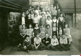
Riverway West School Photo
https://search.heritageburnaby.ca/link/archivedescription70550
- Repository
- City of Burnaby Archives
- Date
- 1930
- Collection/Fonds
- Kantonen Family fonds
- Description Level
- Item
- Physical Description
- 1 photograph (jpeg) : b&w
- Scope and Content
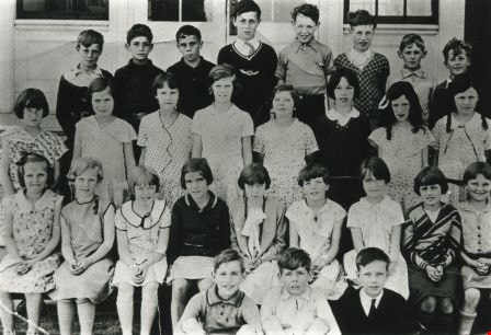
- Photograph is a class picture at Riverway West school taken about 1930. Only one student has been identified - fourth from the left in the second row is Terttu Ulriki Kantonen (Bertha).
- Repository
- City of Burnaby Archives
- Date
- 1930
- Collection/Fonds
- Kantonen Family fonds
- Physical Description
- 1 photograph (jpeg) : b&w
- Description Level
- Item
- Record No.
- 531-001
- Access Restriction
- No restrictions
- Reproduction Restriction
- No known restrictions
- Accession Number
- 2012-06
- Scope and Content
- Photograph is a class picture at Riverway West school taken about 1930. Only one student has been identified - fourth from the left in the second row is Terttu Ulriki Kantonen (Bertha).
- Subjects
- Buildings - Schools
- Media Type
- Photograph
- Geographic Access
- Marine Drive
- Street Address
- 4340 Marine Drive
- Historic Neighbourhood
- Alta-Vista (Historic Neighbourhood)
- Planning Study Area
- Sussex-Nelson Area
Images
![Rumble Road, [1930] thumbnail](/media/hpo/_Data/_Archives_Images/_Unrestricted/204/204-022.jpg?width=280)
Rumble Road
https://search.heritageburnaby.ca/link/archivedescription35165
- Repository
- City of Burnaby Archives
- Date
- [1930]
- Collection/Fonds
- Burnaby Historical Society fonds
- Description Level
- Item
- Physical Description
- 1 photograph : b&w ; 12.7 x 17.8 cm
- Scope and Content
- Photograph of Rumble Road east of Patterson.
- Repository
- City of Burnaby Archives
- Date
- [1930]
- Collection/Fonds
- Burnaby Historical Society fonds
- Subseries
- Pioneer Tales subseries
- Physical Description
- 1 photograph : b&w ; 12.7 x 17.8 cm
- Description Level
- Item
- Record No.
- 204-022
- Access Restriction
- No restrictions
- Reproduction Restriction
- No known restrictions
- Accession Number
- BHS1988-03
- Scope and Content
- Photograph of Rumble Road east of Patterson.
- Subjects
- Geographic Features - Roads
- Media Type
- Photograph
- Photographer
- Stone, Gene
- Notes
- Title based on contents of photograph
- Geographic Access
- Rumble Street
- Patterson Avenue
- Historic Neighbourhood
- Alta-Vista (Historic Neighbourhood)
- Planning Study Area
- Sussex-Nelson Area
Images
![Rumble Road, [1930] thumbnail](/media/hpo/_Data/_Archives_Images/_Unrestricted/204/204-022.jpg)
![Bill Speirs, [1930] (date of original), copied 1986 thumbnail](/media/hpo/_Data/_Archives_Images/_Unrestricted/204/204-180.jpg?width=280)
Bill Speirs
https://search.heritageburnaby.ca/link/archivedescription35323
- Repository
- City of Burnaby Archives
- Date
- [1930] (date of original), copied 1986
- Collection/Fonds
- Burnaby Historical Society fonds
- Description Level
- Item
- Physical Description
- 1 photograph : b&w ; 12.7 x 17.8 cm print
- Scope and Content
- Photograph of Bill Speirs, leaning against the back of an automobile in front of the Speirs family home on Watling Street (near Frederick Avenue). Bill and his wife, Dell Speirs, moved to Burnaby in 1929.
- Repository
- City of Burnaby Archives
- Date
- [1930] (date of original), copied 1986
- Collection/Fonds
- Burnaby Historical Society fonds
- Subseries
- Pioneer Tales subseries
- Physical Description
- 1 photograph : b&w ; 12.7 x 17.8 cm print
- Description Level
- Item
- Record No.
- 204-180
- Access Restriction
- No restrictions
- Reproduction Restriction
- No known restrictions
- Accession Number
- BHS1988-03
- Scope and Content
- Photograph of Bill Speirs, leaning against the back of an automobile in front of the Speirs family home on Watling Street (near Frederick Avenue). Bill and his wife, Dell Speirs, moved to Burnaby in 1929.
- Names
- Speirs, Bill
- Media Type
- Photograph
- Notes
- Title based on contents of photograph
- Geographic Access
- Watling Street
- Historic Neighbourhood
- Alta-Vista (Historic Neighbourhood)
- Planning Study Area
- Sussex-Nelson Area
Images
![Bill Speirs, [1930] (date of original), copied 1986 thumbnail](/media/hpo/_Data/_Archives_Images/_Unrestricted/204/204-180.jpg)
Speirs family home
https://search.heritageburnaby.ca/link/archivedescription35324
- Repository
- City of Burnaby Archives
- Date
- 1930 (date of original), copied 1986
- Collection/Fonds
- Burnaby Historical Society fonds
- Description Level
- Item
- Physical Description
- 1 photograph : b&w ; 12.7 x 17.8 cm print
- Scope and Content
- Photograph of Dell Speirs in front of the Speirs family home on Watling Street (near Frederick Avenue). Dell was the wife of Bill Speirs.
- Repository
- City of Burnaby Archives
- Date
- 1930 (date of original), copied 1986
- Collection/Fonds
- Burnaby Historical Society fonds
- Subseries
- Pioneer Tales subseries
- Physical Description
- 1 photograph : b&w ; 12.7 x 17.8 cm print
- Description Level
- Item
- Record No.
- 204-181
- Access Restriction
- No restrictions
- Reproduction Restriction
- No known restrictions
- Accession Number
- BHS1988-03
- Scope and Content
- Photograph of Dell Speirs in front of the Speirs family home on Watling Street (near Frederick Avenue). Dell was the wife of Bill Speirs.
- Subjects
- Buildings - Residential - Houses
- Names
- Speirs, Dell
- Media Type
- Photograph
- Notes
- Title based on contents of photograph
- Geographic Access
- Watling Street
- Historic Neighbourhood
- Alta-Vista (Historic Neighbourhood)
- Planning Study Area
- Sussex-Nelson Area
Images

Rorison family home
https://search.heritageburnaby.ca/link/archivedescription35379
- Repository
- City of Burnaby Archives
- Date
- 1930 (date of original), copied 1986
- Collection/Fonds
- Burnaby Historical Society fonds
- Description Level
- Item
- Physical Description
- 1 photograph : b&w ; 12.7 x 17.8 cm print
- Scope and Content
- Photograph of the William Rorison family home at 3907 River Road (later becoming 4593 Marine Drive at Strathern Avenue) in the South Slope area. William Rorison built this house next to another for his mother-in-law. The Rorison family consisted of William Rorison, his wife Alma Rorison (nee Cropl…
- Repository
- City of Burnaby Archives
- Date
- 1930 (date of original), copied 1986
- Collection/Fonds
- Burnaby Historical Society fonds
- Subseries
- Pioneer Tales subseries
- Physical Description
- 1 photograph : b&w ; 12.7 x 17.8 cm print
- Description Level
- Item
- Record No.
- 204-236
- Access Restriction
- No restrictions
- Reproduction Restriction
- No known restrictions
- Accession Number
- BHS1988-03
- Scope and Content
- Photograph of the William Rorison family home at 3907 River Road (later becoming 4593 Marine Drive at Strathern Avenue) in the South Slope area. William Rorison built this house next to another for his mother-in-law. The Rorison family consisted of William Rorison, his wife Alma Rorison (nee Cropley) and their children: Kay (later Kay North), Evelyn, Bill, Hugh, and John.
- Subjects
- Buildings - Residential - Houses
- Media Type
- Photograph
- Notes
- Title based on contents of photograph
- Geographic Access
- Marine Drive
- Street Address
- 4593 Marine Drive
- Historic Neighbourhood
- Fraser Arm (Historic Neighbourhood)
- Planning Study Area
- Sussex-Nelson Area
Images
![Children's birthday party, [1930] (date of original), copied 1991 thumbnail](/media/hpo/_Data/_Archives_Images/_Unrestricted/370/370-328.jpg?width=280)
Children's birthday party
https://search.heritageburnaby.ca/link/archivedescription37740
- Repository
- City of Burnaby Archives
- Date
- [1930] (date of original), copied 1991
- Collection/Fonds
- Burnaby Historical Society fonds
- Description Level
- Item
- Physical Description
- 1 photograph : b&w ; 2.6 x 4.5 cm print on contact sheet 20.3 x 26.6 cm
- Scope and Content
- Photograph of a children's birthday party at the Ellis home at 6926 Nelson Avenue. The photograph was taken looking down Nelson Avenue. The children are wearing party hats and standing on a fence.
- Repository
- City of Burnaby Archives
- Date
- [1930] (date of original), copied 1991
- Collection/Fonds
- Burnaby Historical Society fonds
- Subseries
- Burnaby Image Bank subseries
- Physical Description
- 1 photograph : b&w ; 2.6 x 4.5 cm print on contact sheet 20.3 x 26.6 cm
- Description Level
- Item
- Record No.
- 370-328
- Access Restriction
- No restrictions
- Reproduction Restriction
- No known restrictions
- Accession Number
- BHS1999-03
- Scope and Content
- Photograph of a children's birthday party at the Ellis home at 6926 Nelson Avenue. The photograph was taken looking down Nelson Avenue. The children are wearing party hats and standing on a fence.
- Subjects
- Clothing
- Events - Parties
- Media Type
- Photograph
- Notes
- Title based on contents of photograph
- 1 b&w copy negative accompanying
- Negative has a pink cast
- Geographic Access
- Nelson Avenue
- Street Address
- 6926 Nelson Avenue
- Historic Neighbourhood
- Central Park (Historic Neighbourhood)
- Planning Study Area
- Sussex-Nelson Area
Images
![Children's birthday party, [1930] (date of original), copied 1991 thumbnail](/media/hpo/_Data/_Archives_Images/_Unrestricted/370/370-328.jpg)
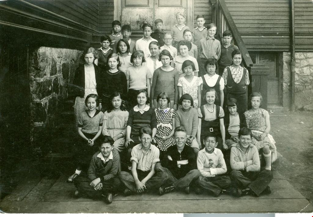
Nelson Avenue School class
https://search.heritageburnaby.ca/link/archivedescription35321
- Repository
- City of Burnaby Archives
- Date
- 1931 (date of original), copied 1986
- Collection/Fonds
- Burnaby Historical Society fonds
- Description Level
- Item
- Physical Description
- 1 photograph : b&w ; 12.7 x 17.8 cm print
- Scope and Content
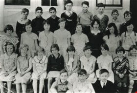
- Photograph of a Grade 5 class at Nelson Avenue School. Patsy Speirs (later Patsy Coe) is in the 3rd row, 4th from the left. Some classmates, not identified, were Lucy Speckman, now Standen (Patsy's best friend); Bev Lewarne (sister of Mayor Bill Lewarne); and, Ruth Thomson The school is located at…
- Repository
- City of Burnaby Archives
- Date
- 1931 (date of original), copied 1986
- Collection/Fonds
- Burnaby Historical Society fonds
- Subseries
- Pioneer Tales subseries
- Physical Description
- 1 photograph : b&w ; 12.7 x 17.8 cm print
- Description Level
- Item
- Record No.
- 204-178
- Access Restriction
- No restrictions
- Reproduction Restriction
- No known restrictions
- Accession Number
- BHS1988-03
- Scope and Content
- Photograph of a Grade 5 class at Nelson Avenue School. Patsy Speirs (later Patsy Coe) is in the 3rd row, 4th from the left. Some classmates, not identified, were Lucy Speckman, now Standen (Patsy's best friend); Bev Lewarne (sister of Mayor Bill Lewarne); and, Ruth Thomson The school is located at 4850 Irmin Street, at the corner of Nelson Avenue and Rumble Street.
- Media Type
- Photograph
- Notes
- Title based on contents of photograph
- Geographic Access
- Irmin Street
- Street Address
- 4850 Irmin Street
- Historic Neighbourhood
- Alta-Vista (Historic Neighbourhood)
- Planning Study Area
- Sussex-Nelson Area
Images
Rumble Street
https://search.heritageburnaby.ca/link/archivedescription34255
- Repository
- City of Burnaby Archives
- Date
- 1932
- Collection/Fonds
- Burnaby Historical Society fonds
- Description Level
- Item
- Physical Description
- 1 photograph : b&w ; 12.2 x 17.7 cm
- Scope and Content
- Photograph of Rumble Street looking east toward Patterson Avenue, located where the house on the left can be seen.
- Repository
- City of Burnaby Archives
- Date
- 1932
- Collection/Fonds
- Burnaby Historical Society fonds
- Subseries
- Photographs subseries
- Physical Description
- 1 photograph : b&w ; 12.2 x 17.7 cm
- Description Level
- Item
- Record No.
- 011-002
- Access Restriction
- No restrictions
- Reproduction Restriction
- No known restrictions
- Accession Number
- BHS2007-04
- Scope and Content
- Photograph of Rumble Street looking east toward Patterson Avenue, located where the house on the left can be seen.
- Media Type
- Photograph
- Notes
- Title based on contents of photograph
- Annotation at bottom of Copy 2 reads, "Rumble St. just after Municipal dump was filled / Facing east house on left is where Patterson Avenue [is]"
- Geographic Access
- Rumble Street
- Patterson Avenue
- Historic Neighbourhood
- Alta-Vista (Historic Neighbourhood)
- Planning Study Area
- Sussex-Nelson Area
- Suncrest Area
Images
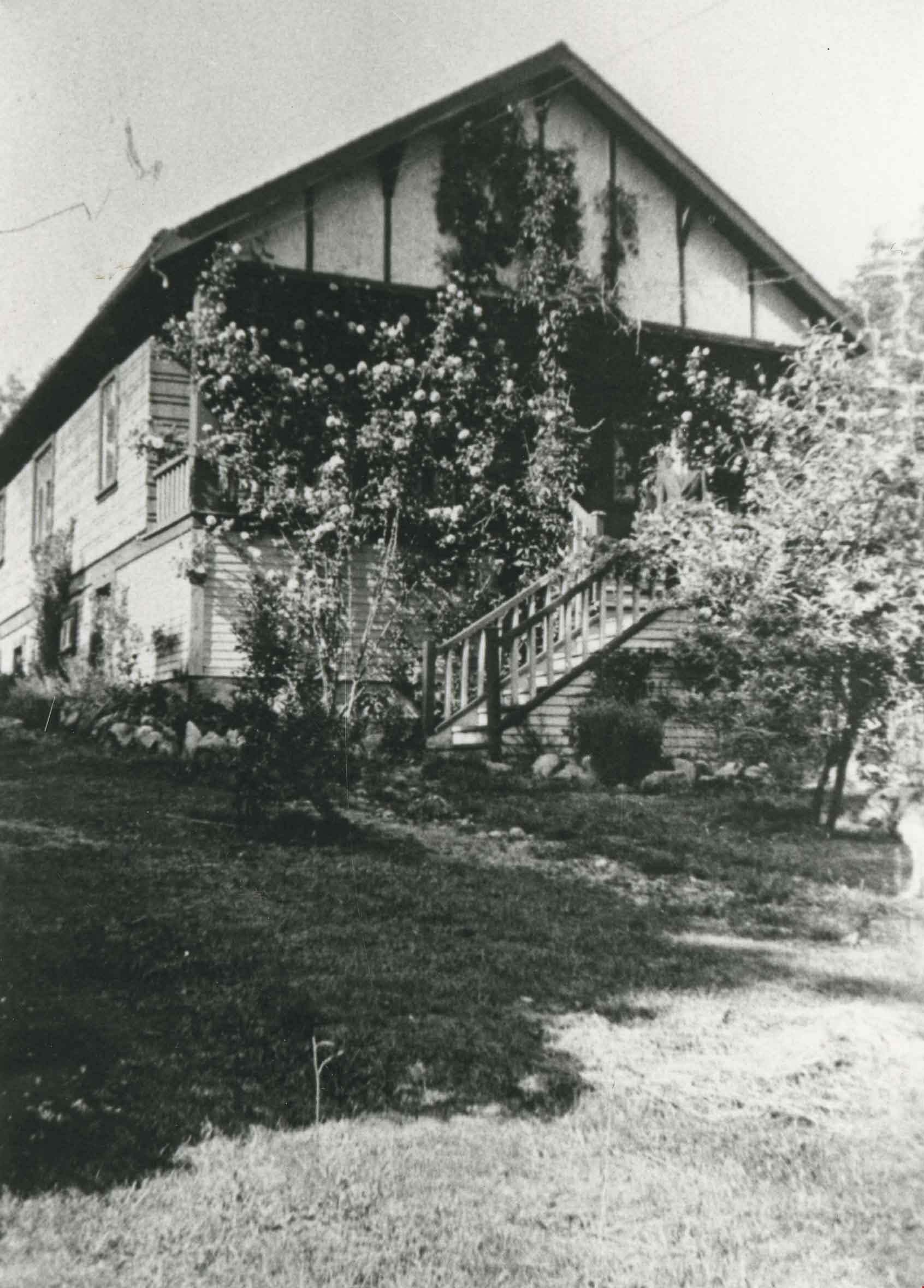
![Lewarne family home, [1933] (date of original), copied 1986 thumbnail](/media/hpo/_Data/_Archives_Images/_Unrestricted/204/204-053.jpg?width=280)
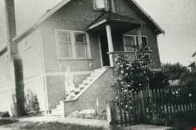
Lewarne family home
https://search.heritageburnaby.ca/link/archivedescription35196
- Repository
- City of Burnaby Archives
- Date
- [1933] (date of original), copied 1986
- Collection/Fonds
- Burnaby Historical Society fonds
- Description Level
- Item
- Physical Description
- 1 photograph : b&w ; 12.7 x 20.3 cm print
- Scope and Content
- Photograph of Lewarne family home on Nelson Avenue in Alta Vista.
- Repository
- City of Burnaby Archives
- Date
- [1933] (date of original), copied 1986
- Collection/Fonds
- Burnaby Historical Society fonds
- Subseries
- Pioneer Tales subseries
- Physical Description
- 1 photograph : b&w ; 12.7 x 20.3 cm print
- Description Level
- Item
- Record No.
- 204-053
- Access Restriction
- No restrictions
- Reproduction Restriction
- No known restrictions
- Accession Number
- BHS1988-03
- Scope and Content
- Photograph of Lewarne family home on Nelson Avenue in Alta Vista.
- Subjects
- Buildings - Residential - Houses
- Media Type
- Photograph
- Notes
- Title based on contents of photograph
- Geographic Access
- Nelson Avenue
- Historic Neighbourhood
- Alta-Vista (Historic Neighbourhood)
- Planning Study Area
- Sussex-Nelson Area
Images
![Lewarne family home, [1933] (date of original), copied 1986 thumbnail](/media/hpo/_Data/_Archives_Images/_Unrestricted/204/204-053.jpg)
![Jim Ellis on Bicycle, [ca. 1933] (date of original), copied 1991 thumbnail](/media/hpo/_Data/_Archives_Images/_Unrestricted/370/370-329.jpg?width=280)
Jim Ellis on Bicycle
https://search.heritageburnaby.ca/link/archivedescription37741
- Repository
- City of Burnaby Archives
- Date
- [ca. 1933] (date of original), copied 1991
- Collection/Fonds
- Burnaby Historical Society fonds
- Description Level
- Item
- Physical Description
- 1 photograph : b&w ; 4.1 x 2.3 cm print on contact sheet 20.3 x 26.6 cm
- Scope and Content
- Photograph of Jim Ellis, on a bicycle, at the side of 6926 Nelson Avenue.
- Repository
- City of Burnaby Archives
- Date
- [ca. 1933] (date of original), copied 1991
- Collection/Fonds
- Burnaby Historical Society fonds
- Subseries
- Burnaby Image Bank subseries
- Physical Description
- 1 photograph : b&w ; 4.1 x 2.3 cm print on contact sheet 20.3 x 26.6 cm
- Description Level
- Item
- Record No.
- 370-329
- Access Restriction
- No restrictions
- Reproduction Restriction
- No restrictions
- Accession Number
- BHS1999-03
- Scope and Content
- Photograph of Jim Ellis, on a bicycle, at the side of 6926 Nelson Avenue.
- Subjects
- Transportation - Bicycles
- Names
- Ellis, Jim
- Media Type
- Photograph
- Notes
- Title based on contents of photograph
- 1 b&w copy negative accompanying
- Negative has a pink cast
- Geographic Access
- Nelson Avenue
- Street Address
- 6926 Nelson Avenue
- Historic Neighbourhood
- Central Park (Historic Neighbourhood)
- Planning Study Area
- Sussex-Nelson Area
Images
![Jim Ellis on Bicycle, [ca. 1933] (date of original), copied 1991 thumbnail](/media/hpo/_Data/_Archives_Images/_Unrestricted/370/370-329.jpg)
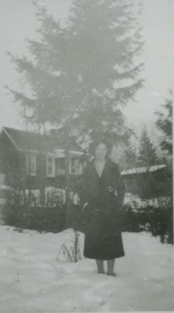
Evelyn Le Grove
https://search.heritageburnaby.ca/link/archivedescription38047
- Repository
- City of Burnaby Archives
- Date
- February 1933 (date of original), copied 1991
- Collection/Fonds
- Burnaby Historical Society fonds
- Description Level
- Item
- Physical Description
- 1 photograph : b&w ; 4.4 x 2.5 cm print on contact sheet 20.2 x 26.6 cm
- Scope and Content
- Photograph of Evelyn Le Grove at McGregor Avenue and Portland Street in the snow. A house can be seen in the background.
- Repository
- City of Burnaby Archives
- Date
- February 1933 (date of original), copied 1991
- Collection/Fonds
- Burnaby Historical Society fonds
- Subseries
- Burnaby Image Bank subseries
- Physical Description
- 1 photograph : b&w ; 4.4 x 2.5 cm print on contact sheet 20.2 x 26.6 cm
- Description Level
- Item
- Record No.
- 370-634
- Access Restriction
- No restrictions
- Reproduction Restriction
- No known restrictions
- Accession Number
- BHS1999-03
- Scope and Content
- Photograph of Evelyn Le Grove at McGregor Avenue and Portland Street in the snow. A house can be seen in the background.
- Names
- Le Grove, Evelyn Hardy
- Media Type
- Photograph
- Notes
- Title based on contents of photograph
- 1 b&w copy negative accompanying
- Negative has a pink cast
- Geographic Access
- McGregor Avenue
- Portland Street
- Historic Neighbourhood
- Alta-Vista (Historic Neighbourhood)
- Planning Study Area
- Sussex-Nelson Area
Images
![Burnaby Sports Day, [between 1936 and 1939] thumbnail](/media/Hpo/_Data/_Archives_Moving_Images/_Unrestricted/562-002-3.jpg?width=280)
Burnaby Sports Day
https://search.heritageburnaby.ca/link/archivedescription85204
- Repository
- City of Burnaby Archives
- Date
- [between 1936 and 1939]
- Collection/Fonds
- Digney Family fonds
- Description Level
- Item
- Physical Description
- 1 film clip (8 min., 37 sec.) : digital, col., si.
- Scope and Content
- Item is a digitized copy of a silent colour film segment with footage of the annual Sports Day events held at Burnaby Central Park. The film opens with an unidentified dedication ceremony and tree planting in an unknown location and switches to students marching into Central Park. Hundreds of child…
- Repository
- City of Burnaby Archives
- Date
- [between 1936 and 1939]
- Collection/Fonds
- Digney Family fonds
- Physical Description
- 1 film clip (8 min., 37 sec.) : digital, col., si.
- Description Level
- Item
- Record No.
- 562-002-3
- Access Restriction
- No restrictions
- Reproduction Restriction
- May be restricted by third party rights
- Accession Number
- 2012-15
- Scope and Content
- Item is a digitized copy of a silent colour film segment with footage of the annual Sports Day events held at Burnaby Central Park. The film opens with an unidentified dedication ceremony and tree planting in an unknown location and switches to students marching into Central Park. Hundreds of children and Youth are showcased in sporting field events and competitions such as track and field sports, acrobatics, gymnastics, dancing, leap frog, skipping, rugby.
- Subjects
- Events - Parades
- Occupations
- Occupations - Labourers
- Organizations - Mens' Societies and Clubs
- Organizations - Womens' Societies and Clubs
- Media Type
- Moving Images
- Photographer
- Digney, Andy
- Creator
- Digney, Andy
- Notes
- Title based on contents of film
- Film clip originates from digitized version of original 16 mm film footage (item 562-002). This segment was part of digitized portion titled 'May Day Events'
- Geographic Access
- Kingsway
- Central Park
- Street Address
- 3883 Imperial Street
- Historic Neighbourhood
- Central Park (Historic Neighbourhood)
- Planning Study Area
- Sussex-Nelson Area
Images
![Burnaby Sports Day, [between 1936 and 1939] thumbnail](/media/Hpo/_Data/_Archives_Moving_Images/_Unrestricted/562-002-3.jpg)
Video
Burnaby Sports Day, [between 1936 and 1939]
Burnaby Sports Day, [between 1936 and 1939]
https://search.heritageburnaby.ca/media/hpo/_Data/_Archives_Moving_Images/_Unrestricted/562-002-3.m4v