Narrow Results By

Alta Vista Baptist Church
https://search.heritageburnaby.ca/link/landmark557
- Repository
- Burnaby Heritage Planning
- Description
- Church building.
- Associated Dates
- 1936
- Other Names
- Royal Oak Community Church
- Street View URL
- Google Maps Street View
- Repository
- Burnaby Heritage Planning
- Other Names
- Royal Oak Community Church
- Geographic Access
- Royal Oak Avenue
- Associated Dates
- 1936
- Description
- Church building.
- Heritage Value
- This Baptist congregation originally held services in a tent at the corner of McGregor Avenue and Portland but they soon were able to build a small church. A membership drive by Pastor Arthur James Bowbrick (1875-1961) was so successful that the congregation was able build this fine structure, prominently located at the corner of Victory Street. Although it has been altered with later additions and stucco over the original siding, the original windows and the rooftop belfry remain.
- Locality
- Alta Vista
- Historic Neighbourhood
- Alta Vista (Historic Neighbourhood)
- Planning Study Area
- Sussex-Nelson Area
- Ownership
- Private
- Street Address
- 7175 Royal Oak Avenue
- Street View URL
- Google Maps Street View
Images


Alta Vista Neighbourhood
https://search.heritageburnaby.ca/link/landmark707
- Repository
- Burnaby Heritage Planning
- Associated Dates
- 1925-1954
- Heritage Value
- As with many areas of Burnaby during this period, the years after World War Two marked a rapid growth in residential development in the Alta-Vista Neighbourhood. Subdivisions like Sussex and Suncrest were built and new schools and amenities were constructed to meet the demands of increased population.
- Historic Neighbourhood
- Alta Vista (Historic Neighbourhood)
- Planning Study Area
- Sussex-Nelson Area
Images


Alta Vista Neighbourhood
https://search.heritageburnaby.ca/link/landmark766
- Repository
- Burnaby Heritage Planning
- Associated Dates
- 1905-1924
- Heritage Value
- Alta Vista, named for its high views of the Fraser Valley, rapidly grew during the period 1910-1912, seeing its settlement jump from about a dozen buildings in 1910 to about four hundred by the end of 1912. Home-seekers were attracted to its location just a short walk from the B.C.E.R. line at Royal Oak and Highland Park and easily accessible to both New Westminster and Vancouver.
- Historic Neighbourhood
- Alta Vista (Historic Neighbourhood)
- Planning Study Area
- Sussex-Nelson Area
Images


O.G. Naud House
https://search.heritageburnaby.ca/link/landmark509
- Repository
- Burnaby Heritage Planning
- Description
- The O.G. Naud House is a south facing, two-storey house with a bellcast hipped roof, set on a high basement. It features a double-height front verandah supported by classical columns. It is located on Victory Street in the Alta Vista neighbourhood of South Burnaby, and is one of the oldest houses i…
- Associated Dates
- 1908
- Formal Recognition
- Heritage Designation, Community Heritage Register
- Other Names
- Onezime & Charlsie Naud House
- Street View URL
- Google Maps Street View
- Repository
- Burnaby Heritage Planning
- Other Names
- Onezime & Charlsie Naud House
- Geographic Access
- Victory Street
- Associated Dates
- 1908
- Formal Recognition
- Heritage Designation, Community Heritage Register
- Enactment Type
- By-law No. 12316
- Enactment Date
- 26/05/2008
- Description
- The O.G. Naud House is a south facing, two-storey house with a bellcast hipped roof, set on a high basement. It features a double-height front verandah supported by classical columns. It is located on Victory Street in the Alta Vista neighbourhood of South Burnaby, and is one of the oldest houses in the area.
- Heritage Value
- Built in 1908, the O.G. Naud House is valued as one of the first houses to be built in the Alta Vista neighbourhood and is a direct link to the first settlement of the area. Close proximity to the B.C. Electric Railway streetcar line, at Royal Oak and Highland Park, permitted easy access to New Westminster and Vancouver. These transportation links, combined with spectacular views of the Fraser Valley, encouraged the early development of this South Burnaby neighbourhood. The O.G. Naud House is architecturally significant as an example of the influence of the Classical Revival style that had been popularized in Eastern Canada. The basic form of the house is a Foursquare, with a double-height verandah that dominates the symmetrically balanced façade, supported on lathe-turned columns. A central entry and regular fenestration further unify the façade composition. Construction employed locally available materials. The rough-cut foundation stone was harvested from boulders from the G. Ledingham property on the south side of Victory Street. The builder and first owner, Onezime George Naud (1858-1951), was originally from St. Albans, Quebec. He worked on railway construction in Alabama, where he met his wife, Charlsie Elizabeth Sims (1869-1974). He later took part in the 1898 Gold Rush in Atlin, then worked as a stonemason on CPR culverts and bridges across B.C. An accomplished stonemason, Naud also worked on the original Vancouver and New Westminster post offices, the Parliament buildings in Victoria, and the Capitol building in Olympia, Washington.
- Defining Elements
- The key characteristics that define the heritage character of the O.G. Naud House include its: - south-facing location, with generous set back from the street, in the Alta Vista neighbourhood of South Burnaby - residential form, scale and massing as expressed by its two-storey height plus full basement, bellcast hipped roof, rectangular plan and front projecting double-height verandah - masonry construction materials such as the rough-cut granite foundation - wood-frame construction, including lapped wooden siding and shingle siding extant under later cladding - Edwardian era features including lathe-turned columns, balustrades of dimensional lumber, scroll-cut bargeboards in front gable, and scroll-cut eave brackets - associated landscape features including lane access to the east, large cedar trees and perimeter plantings
- Historic Neighbourhood
- Alta Vista (Historic Neighbourhood)
- Planning Study Area
- Sussex-Nelson Area
- Function
- Primary Historic--Single Dwelling
- Community
- Alta Vista
- Cadastral Identifier
- P.I.D.003-100-375
- Boundaries
- The O.G. Naud House is comprised of a single residential lot located at 4737 Victory Street, Burnaby.
- Area
- 1099.47
- Contributing Resource
- Building
- Ownership
- Private
- Documentation
- City of Burnaby Planning and Building Department, Heritage Site Files
- Street Address
- 4737 Victory Street
- Street View URL
- Google Maps Street View
Images


Richard & Alice Dunn Residence
https://search.heritageburnaby.ca/link/landmark552
- Repository
- Burnaby Heritage Planning
- Description
- Residential building.
- Associated Dates
- 1939
- Street View URL
- Google Maps Street View
- Repository
- Burnaby Heritage Planning
- Geographic Access
- Jubilee Avenue
- Associated Dates
- 1939
- Description
- Residential building.
- Heritage Value
- This house was built for Richard Dunn, a police sergeant with the B.C. Police force and his wife Alice. This house is a notable example of a Storybook Cottage, dating from just prior to the outbreak of the Second World War. Modest houses of the era often assumed a cottage appearance that provided a romantic ideal of traditional domesticity. With its smooth, planar stucco, severely-clipped roof edges, round-arched door and windows, side arch with a catslide roof, cross-leaded glass and brick detailing, this house is an excellent example of this picturesque housing trend. Located on a corner lot, the house was sited at an angle. The large Chilean Pine, or monkey-puzzle tree, entrance is a remarkable specimen.
- Locality
- Alta Vista
- Historic Neighbourhood
- Alta Vista (Historic Neighbourhood)
- Planning Study Area
- Sussex-Nelson Area
- Ownership
- Private
- Street Address
- 7207 Jubilee Avenue
- Street View URL
- Google Maps Street View
Images


Sussex Avenue School
https://search.heritageburnaby.ca/link/landmark815
- Repository
- Burnaby Heritage Planning
- Geographic Access
- Irmin Street
- Associated Dates
- 1955-1982
- Heritage Value
- Sussex Avenue school was another school built during the peak expansion years of the 1950s and early 1960s. Burnaby's population was growing at such a fast pace during that decade that 10 new schools were built, and existing schools were expanded. Sussex Avenue School opened with 304 pupils. By the 1970s, student enrolment had slowed considerably from its peak and as a result, a number of schools - including Sussex - were closed.
- Historic Neighbourhood
- Alta Vista (Historic Neighbourhood)
- Planning Study Area
- Sussex-Nelson Area
- Street Address
- 4443 Irmin Street
Images

Sussex-Nelson Neighbourhood
https://search.heritageburnaby.ca/link/landmark838
- Repository
- Burnaby Heritage Planning
- Associated Dates
- 1955-2008
- Heritage Value
- The Sussex-Nelson Neighbourhood is located just south of Metrotown and in 1980 was characterised as the most populated of all of Burnaby's Planning Study areas. The area immediately south of Metrotown was initially developed as post-war 1950s housing stock, while the sector south of Rumble was developed after the 1960s and 1970s as single-family housing.
- Historic Neighbourhood
- Alta Vista (Historic Neighbourhood)
- Planning Study Area
- Sussex-Nelson Area
Images

![Bill Speirs, [1930] (date of original), copied 1986 thumbnail](/media/hpo/_Data/_Archives_Images/_Unrestricted/204/204-180.jpg?width=280)
Bill Speirs
https://search.heritageburnaby.ca/link/archivedescription35323
- Repository
- City of Burnaby Archives
- Date
- [1930] (date of original), copied 1986
- Collection/Fonds
- Burnaby Historical Society fonds
- Description Level
- Item
- Physical Description
- 1 photograph : b&w ; 12.7 x 17.8 cm print
- Scope and Content
- Photograph of Bill Speirs, leaning against the back of an automobile in front of the Speirs family home on Watling Street (near Frederick Avenue). Bill and his wife, Dell Speirs, moved to Burnaby in 1929.
- Repository
- City of Burnaby Archives
- Date
- [1930] (date of original), copied 1986
- Collection/Fonds
- Burnaby Historical Society fonds
- Subseries
- Pioneer Tales subseries
- Physical Description
- 1 photograph : b&w ; 12.7 x 17.8 cm print
- Description Level
- Item
- Record No.
- 204-180
- Access Restriction
- No restrictions
- Reproduction Restriction
- No known restrictions
- Accession Number
- BHS1988-03
- Scope and Content
- Photograph of Bill Speirs, leaning against the back of an automobile in front of the Speirs family home on Watling Street (near Frederick Avenue). Bill and his wife, Dell Speirs, moved to Burnaby in 1929.
- Names
- Speirs, Bill
- Media Type
- Photograph
- Notes
- Title based on contents of photograph
- Geographic Access
- Watling Street
- Historic Neighbourhood
- Alta-Vista (Historic Neighbourhood)
- Planning Study Area
- Sussex-Nelson Area
Images
![Bill Speirs, [1930] (date of original), copied 1986 thumbnail](/media/hpo/_Data/_Archives_Images/_Unrestricted/204/204-180.jpg)
![Burnaby, [between 1937 and 1938] thumbnail](/media/Hpo/_Data/_Archives_Moving_Images/_Unrestricted/562-002-5.jpg?width=280)
Burnaby
https://search.heritageburnaby.ca/link/archivedescription85235
- Repository
- City of Burnaby Archives
- Date
- [between 1937 and 1938]
- Collection/Fonds
- Digney Family fonds
- Description Level
- Item
- Physical Description
- 1 film clip (9 min., 26 sec.) : digital, b&w, col., si.
- Scope and Content
- Item is a silent digitized film segment identified as Reel 5. The film segment opens with black and white footage of a Burnaby May Day Parade. Children are seen in costumes pushing carriages and bicycles along with pets as they come to gather at Central Park for judging. This event is followed with…
- Repository
- City of Burnaby Archives
- Date
- [between 1937 and 1938]
- Collection/Fonds
- Digney Family fonds
- Physical Description
- 1 film clip (9 min., 26 sec.) : digital, b&w, col., si.
- Description Level
- Item
- Record No.
- 562-003-5
- Access Restriction
- No restrictions
- Reproduction Restriction
- May be restricted by third party rights
- Accession Number
- 2014-04
- Scope and Content
- Item is a silent digitized film segment identified as Reel 5. The film segment opens with black and white footage of a Burnaby May Day Parade. Children are seen in costumes pushing carriages and bicycles along with pets as they come to gather at Central Park for judging. This event is followed with colour footage of a gymkhana event with people riding horses at the Lubbock farm in Burnaby and closes with Victory Bond fundraising outside the Oak Theatre, a parade on Kingsway and contrails from an airplane. Many of the men can be seen marching in the parade with their A.R.P. (Air Raid Precautions) uniforms and arm bands.
- Media Type
- Moving Images
- Photographer
- Digney, Andy
- Creator
- Digney, Andy
- Notes
- Title based on contents of film
- Geographic Access
- Kingsway
- Historic Neighbourhood
- Central Park (Historic Neighbourhood)
- Planning Study Area
- Sussex-Nelson Area
Images
![Burnaby, [between 1937 and 1938] thumbnail](/media/Hpo/_Data/_Archives_Moving_Images/_Unrestricted/562-002-5.jpg)
Video
Burnaby, [between 1937 and 1938]
Burnaby, [between 1937 and 1938]
https://search.heritageburnaby.ca/media/hpo/_Data/_Archives_Moving_Images/_Unrestricted/562-003-5.m4v![Burnaby Sports Day, [between 1936 and 1939] thumbnail](/media/Hpo/_Data/_Archives_Moving_Images/_Unrestricted/562-002-3.jpg?width=280)
Burnaby Sports Day
https://search.heritageburnaby.ca/link/archivedescription85204
- Repository
- City of Burnaby Archives
- Date
- [between 1936 and 1939]
- Collection/Fonds
- Digney Family fonds
- Description Level
- Item
- Physical Description
- 1 film clip (8 min., 37 sec.) : digital, col., si.
- Scope and Content
- Item is a digitized copy of a silent colour film segment with footage of the annual Sports Day events held at Burnaby Central Park. The film opens with an unidentified dedication ceremony and tree planting in an unknown location and switches to students marching into Central Park. Hundreds of child…
- Repository
- City of Burnaby Archives
- Date
- [between 1936 and 1939]
- Collection/Fonds
- Digney Family fonds
- Physical Description
- 1 film clip (8 min., 37 sec.) : digital, col., si.
- Description Level
- Item
- Record No.
- 562-002-3
- Access Restriction
- No restrictions
- Reproduction Restriction
- May be restricted by third party rights
- Accession Number
- 2012-15
- Scope and Content
- Item is a digitized copy of a silent colour film segment with footage of the annual Sports Day events held at Burnaby Central Park. The film opens with an unidentified dedication ceremony and tree planting in an unknown location and switches to students marching into Central Park. Hundreds of children and Youth are showcased in sporting field events and competitions such as track and field sports, acrobatics, gymnastics, dancing, leap frog, skipping, rugby.
- Subjects
- Events - Parades
- Occupations
- Occupations - Labourers
- Organizations - Mens' Societies and Clubs
- Organizations - Womens' Societies and Clubs
- Media Type
- Moving Images
- Photographer
- Digney, Andy
- Creator
- Digney, Andy
- Notes
- Title based on contents of film
- Film clip originates from digitized version of original 16 mm film footage (item 562-002). This segment was part of digitized portion titled 'May Day Events'
- Geographic Access
- Kingsway
- Central Park
- Street Address
- 3883 Imperial Street
- Historic Neighbourhood
- Central Park (Historic Neighbourhood)
- Planning Study Area
- Sussex-Nelson Area
Images
![Burnaby Sports Day, [between 1936 and 1939] thumbnail](/media/Hpo/_Data/_Archives_Moving_Images/_Unrestricted/562-002-3.jpg)
Video
Burnaby Sports Day, [between 1936 and 1939]
Burnaby Sports Day, [between 1936 and 1939]
https://search.heritageburnaby.ca/media/hpo/_Data/_Archives_Moving_Images/_Unrestricted/562-002-3.m4v![Car in Driveway, [ca. 1950] (date of original), copied 1991 thumbnail](/media/hpo/_Data/_Archives_Images/_Unrestricted/370/370-670.jpg?width=280)
Car in Driveway
https://search.heritageburnaby.ca/link/archivedescription38083
- Repository
- City of Burnaby Archives
- Date
- [ca. 1950] (date of original), copied 1991
- Collection/Fonds
- Burnaby Historical Society fonds
- Description Level
- Item
- Physical Description
- 1 photograph : b&w ; 2.9 x 4.8 cm print on contact sheet 20.2 x 26.2 cm
- Scope and Content
- Photograph of a car parked in the driveway at the back of 2337 Waverley Avenue (later renumbered 6926 Waverley Avenue).
- Repository
- City of Burnaby Archives
- Date
- [ca. 1950] (date of original), copied 1991
- Collection/Fonds
- Burnaby Historical Society fonds
- Subseries
- Burnaby Image Bank subseries
- Physical Description
- 1 photograph : b&w ; 2.9 x 4.8 cm print on contact sheet 20.2 x 26.2 cm
- Description Level
- Item
- Record No.
- 370-670
- Access Restriction
- No restrictions
- Reproduction Restriction
- No restrictions
- Accession Number
- BHS1999-03
- Scope and Content
- Photograph of a car parked in the driveway at the back of 2337 Waverley Avenue (later renumbered 6926 Waverley Avenue).
- Subjects
- Transportation - Automobiles
- Media Type
- Photograph
- Notes
- Title based on contents of photograph
- 1 b&w copy negative accompanying
- Negative has a pink cast
- Geographic Access
- Waverley Avenue
- Street Address
- 6926 Waverley Avenue
- Historic Neighbourhood
- Alta-Vista (Historic Neighbourhood)
- Planning Study Area
- Sussex-Nelson Area
Images
![Car in Driveway, [ca. 1950] (date of original), copied 1991 thumbnail](/media/hpo/_Data/_Archives_Images/_Unrestricted/370/370-670.jpg)
![Children's birthday party, [1930] (date of original), copied 1991 thumbnail](/media/hpo/_Data/_Archives_Images/_Unrestricted/370/370-328.jpg?width=280)
Children's birthday party
https://search.heritageburnaby.ca/link/archivedescription37740
- Repository
- City of Burnaby Archives
- Date
- [1930] (date of original), copied 1991
- Collection/Fonds
- Burnaby Historical Society fonds
- Description Level
- Item
- Physical Description
- 1 photograph : b&w ; 2.6 x 4.5 cm print on contact sheet 20.3 x 26.6 cm
- Scope and Content
- Photograph of a children's birthday party at the Ellis home at 6926 Nelson Avenue. The photograph was taken looking down Nelson Avenue. The children are wearing party hats and standing on a fence.
- Repository
- City of Burnaby Archives
- Date
- [1930] (date of original), copied 1991
- Collection/Fonds
- Burnaby Historical Society fonds
- Subseries
- Burnaby Image Bank subseries
- Physical Description
- 1 photograph : b&w ; 2.6 x 4.5 cm print on contact sheet 20.3 x 26.6 cm
- Description Level
- Item
- Record No.
- 370-328
- Access Restriction
- No restrictions
- Reproduction Restriction
- No known restrictions
- Accession Number
- BHS1999-03
- Scope and Content
- Photograph of a children's birthday party at the Ellis home at 6926 Nelson Avenue. The photograph was taken looking down Nelson Avenue. The children are wearing party hats and standing on a fence.
- Subjects
- Clothing
- Events - Parties
- Media Type
- Photograph
- Notes
- Title based on contents of photograph
- 1 b&w copy negative accompanying
- Negative has a pink cast
- Geographic Access
- Nelson Avenue
- Street Address
- 6926 Nelson Avenue
- Historic Neighbourhood
- Central Park (Historic Neighbourhood)
- Planning Study Area
- Sussex-Nelson Area
Images
![Children's birthday party, [1930] (date of original), copied 1991 thumbnail](/media/hpo/_Data/_Archives_Images/_Unrestricted/370/370-328.jpg)
Children's theatrical performance at the Oak Theatre
https://search.heritageburnaby.ca/link/archivedescription85469
- Repository
- City of Burnaby Archives
- Date
- 1939
- Collection/Fonds
- Digney Family fonds
- Description Level
- Item
- Physical Description
- 1 film clip (1 min., 36 sec.) : digital, b&w ; si.
- Scope and Content
- Item is a digitized copy of a black and white film segment of an unidentified theatrical production at the Oak Theatre with children as the performers. Children appear in costume with some dressed as mice or rats and cats dancing and performing on the stage while others are dressed as townsfolk. Th…
- Repository
- City of Burnaby Archives
- Date
- 1939
- Collection/Fonds
- Digney Family fonds
- Physical Description
- 1 film clip (1 min., 36 sec.) : digital, b&w ; si.
- Description Level
- Item
- Record No.
- 562-002-5
- Access Restriction
- No restrictions
- Reproduction Restriction
- May be restricted by third party rights
- Accession Number
- 2012-15
- Scope and Content
- Item is a digitized copy of a black and white film segment of an unidentified theatrical production at the Oak Theatre with children as the performers. Children appear in costume with some dressed as mice or rats and cats dancing and performing on the stage while others are dressed as townsfolk. The play closely resembles the folk tale 'The Pied Piper of Hamelin' (also known as The Pan Piper, the Rat Catcher of Hamelin).
- Names
- Oak Theatre
- Media Type
- Moving Images
- Photographer
- Digney, Andy
- Creator
- Digney, Andy
- Notes
- Title based on contents of film
- Film clip originates from digitized version of original 16 mm film footage (item 562-002). This segment was part of digitized portion titled 'Royal Visit'
- Storage location refers to location of DVD containing this clip. See 562-002 notes for more information. Additional copies of video file stored in Permanent drive accession folder.
- Geographic Access
- Kingsway
- Central Park
- Historic Neighbourhood
- Central Park (Historic Neighbourhood)
- Planning Study Area
- Sussex-Nelson Area
Images
Video
Children's theatrical performance at the Oak Theatre, 1939
Children's theatrical performance at the Oak Theatre, 1939
https://search.heritageburnaby.ca/media/hpo/_Data/_Archives_Moving_Images/_Unrestricted/562-002-5.m4v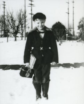
David Ellis
https://search.heritageburnaby.ca/link/archivedescription37718
- Repository
- City of Burnaby Archives
- Date
- 1952 (date of original), copied 1991
- Collection/Fonds
- Burnaby Historical Society fonds
- Description Level
- Item
- Physical Description
- 1 photograph : b&w ; 4.3 x 3.4 cm print on contact sheet 20.6 x 26.1 cm
- Scope and Content
- Photograph of David Ellis, leaving for school, in front of 6926 Nelson Avenue, the home of James and Sarah Ellis, his grandparents.
- Repository
- City of Burnaby Archives
- Date
- 1952 (date of original), copied 1991
- Collection/Fonds
- Burnaby Historical Society fonds
- Subseries
- Burnaby Image Bank subseries
- Physical Description
- 1 photograph : b&w ; 4.3 x 3.4 cm print on contact sheet 20.6 x 26.1 cm
- Description Level
- Item
- Record No.
- 370-306
- Access Restriction
- No restrictions
- Reproduction Restriction
- No restrictions
- Accession Number
- BHS1999-03
- Scope and Content
- Photograph of David Ellis, leaving for school, in front of 6926 Nelson Avenue, the home of James and Sarah Ellis, his grandparents.
- Subjects
- Natural Phenomena - Snow
- Names
- Ellis, David
- Media Type
- Photograph
- Notes
- Title based on contents of photograph
- 1 b&w copy negative accompanying
- Negative has a pink cast
- Geographic Access
- Nelson Avenue
- Street Address
- 6926 Nelson Avenue
- Historic Neighbourhood
- Central Park (Historic Neighbourhood)
- Planning Study Area
- Sussex-Nelson Area
Images

Digney family home at Christmas
https://search.heritageburnaby.ca/link/archivedescription85470
- Repository
- City of Burnaby Archives
- Date
- 1939
- Collection/Fonds
- Digney Family fonds
- Description Level
- Item
- Physical Description
- 1 film clip (1min., 18 sec.) : digital, col. ; si.
- Scope and Content
- Item is a digitized copy of a silent colour film segment of the Digney family at Christmas. Film opens with views of a rhododendrun bush and moves into footage showing the outside and inside their home at Christmas time.
- Repository
- City of Burnaby Archives
- Date
- 1939
- Collection/Fonds
- Digney Family fonds
- Physical Description
- 1 film clip (1min., 18 sec.) : digital, col. ; si.
- Description Level
- Item
- Record No.
- 562-002-6
- Access Restriction
- No restrictions
- Reproduction Restriction
- May be restricted by third party rights
- Accession Number
- 2012-15
- Scope and Content
- Item is a digitized copy of a silent colour film segment of the Digney family at Christmas. Film opens with views of a rhododendrun bush and moves into footage showing the outside and inside their home at Christmas time.
- Subjects
- Holidays - Christmas
- Names
- Digney, Andy
- Media Type
- Moving Images
- Photographer
- Digney, Andy
- Creator
- Digney, Andy
- Notes
- Title based on contents of film
- Film clip originates from digitized version of original 16 mm film footage (item 562-002). This segment was part of digitized portion titled 'Royal Visit'
- Geographic Access
- Central Park
- Kingsway
- Historic Neighbourhood
- Central Park (Historic Neighbourhood)
- Planning Study Area
- Sussex-Nelson Area
Images

Video
Digney family home at Christmas, 1939
Digney family home at Christmas, 1939
https://search.heritageburnaby.ca/media/hpo/_Data/_Archives_Moving_Images/_Unrestricted/562-002-6.m4v![Digney Pee-Wee Bowling League, [1958 or 1959] thumbnail](/media/hpo/_Data/_Archives_Images/_Unrestricted/559/562-001.jpg?width=280)
Digney Pee-Wee Bowling League
https://search.heritageburnaby.ca/link/archivedescription85072
- Repository
- City of Burnaby Archives
- Date
- [1958 or 1959]
- Collection/Fonds
- Digney Family fonds
- Description Level
- Item
- Physical Description
- 1 photograph : b&w ; 40.5 x 104 cm
- Scope and Content
- Panorama photograph of the Digney Pee-Wee Bowling League. Some members are identified as; Ernest Frank "Dig" Digney (back row- far left); Natasha Wiebe (back row-2nd from left); Carol Loew; Cathy Strang; Susan Dunham; Lynne Pemble; Leah Pemble; Karen Proby and Bruce Digney (front row-6th from the …
- Repository
- City of Burnaby Archives
- Date
- [1958 or 1959]
- Collection/Fonds
- Digney Family fonds
- Physical Description
- 1 photograph : b&w ; 40.5 x 104 cm
- Description Level
- Item
- Record No.
- 562-001
- Access Restriction
- No restrictions
- Reproduction Restriction
- No restrictions
- Accession Number
- 2014-09
- Scope and Content
- Panorama photograph of the Digney Pee-Wee Bowling League. Some members are identified as; Ernest Frank "Dig" Digney (back row- far left); Natasha Wiebe (back row-2nd from left); Carol Loew; Cathy Strang; Susan Dunham; Lynne Pemble; Leah Pemble; Karen Proby and Bruce Digney (front row-6th from the left). Andy Digney opened the Digney Bowl on August 19, 1955 and passed the business onto his son Ernest who ran it until his son Bruce Digney took over in 1980. The Digney Bowl was located at 6521 Bonsor Avenue. The bowling league met every Saturday morning at the Digney bowling alley where there were a total of 32 teams (5 children per team) who bowled in shifts since there wasn't enough room for everyone to bowl at once. Paul Digney (the son of Dig Digney) helped out by emptying ashtrays.
- Subjects
- Sports - Bowling
- Names
- Digney Bowling Alley
- Digney, Ernest Frank "Dig"
- Wiebe, Natasha
- Loew, Carol
- Strang, Cathy
- Dunham, Susan
- Pemble, Lynne
- Proby, Karen
- Digney, Bruce
- Digney, Paul
- Media Type
- Photograph
- Notes
- Transcribed title
- Geographic Access
- Bonsor Avenue
- Historic Neighbourhood
- Alta-Vista (Historic Neighbourhood)
- Planning Study Area
- Sussex-Nelson Area
Images
![Digney Pee-Wee Bowling League, [1958 or 1959] thumbnail](/media/hpo/_Data/_Archives_Images/_Unrestricted/559/562-001.jpg)
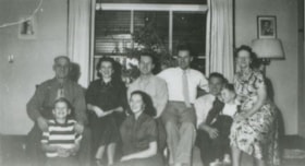
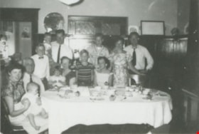
Ellis Family at Christmas, 1951
https://search.heritageburnaby.ca/link/archivedescription37714
- Repository
- City of Burnaby Archives
- Date
- 1951 (date of original), copied 1991
- Collection/Fonds
- Burnaby Historical Society fonds
- Description Level
- Item
- Physical Description
- 1 photograph : b&w ; 2.4 x 4.3 cm print on contact sheet 20.6 x 26.1 cm
- Scope and Content
- Photograph of the Ellis family, Christmas 1951. The photo was taken in the Ellis house at 6926 Nelson Avenue. Left to right: Mr. Ellis, Bobby Ellis, Annie Ellis, Audrey Ellis, Bob Ellis, Harry Ellis, Jim Ellis, David Ellis, and Sarah Ellis.
- Repository
- City of Burnaby Archives
- Date
- 1951 (date of original), copied 1991
- Collection/Fonds
- Burnaby Historical Society fonds
- Subseries
- Burnaby Image Bank subseries
- Physical Description
- 1 photograph : b&w ; 2.4 x 4.3 cm print on contact sheet 20.6 x 26.1 cm
- Description Level
- Item
- Record No.
- 370-302
- Access Restriction
- No restrictions
- Reproduction Restriction
- No restrictions
- Accession Number
- BHS1999-03
- Scope and Content
- Photograph of the Ellis family, Christmas 1951. The photo was taken in the Ellis house at 6926 Nelson Avenue. Left to right: Mr. Ellis, Bobby Ellis, Annie Ellis, Audrey Ellis, Bob Ellis, Harry Ellis, Jim Ellis, David Ellis, and Sarah Ellis.
- Subjects
- Holidays - Christmas
- Names
- Ellis, Annie King
- Ellis, Audrey
- Ellis, Robert "Bob"
- Ellis, Bobby
- Ellis, David
- Ellis, Dr. Harry M.
- Ellis, Jim
- Ellis, Sarah
- Media Type
- Photograph
- Notes
- Title based on contents of photograph
- 1 b&w copy negative accompanying
- Negative has a pink cast
- Geographic Access
- Nelson Avenue
- Street Address
- 6926 Nelson Avenue
- Historic Neighbourhood
- Central Park (Historic Neighbourhood)
- Planning Study Area
- Sussex-Nelson Area
Images
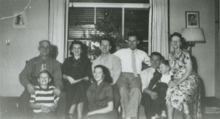
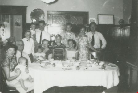
Ellis family gathering
https://search.heritageburnaby.ca/link/archivedescription37754
- Repository
- City of Burnaby Archives
- Date
- 1956 (date of original), copied 1991
- Collection/Fonds
- Burnaby Historical Society fonds
- Description Level
- Item
- Physical Description
- 1 photograph : b&w ; 2.7 x 3.9 cm print on contact sheet 20.5 x 26.4 cm
- Scope and Content
- Photograph of a gathering of the Ellis family inside a family home at 6926 Nelson Avenue. The family is seated and standing beside a set table.
- Repository
- City of Burnaby Archives
- Date
- 1956 (date of original), copied 1991
- Collection/Fonds
- Burnaby Historical Society fonds
- Subseries
- Burnaby Image Bank subseries
- Physical Description
- 1 photograph : b&w ; 2.7 x 3.9 cm print on contact sheet 20.5 x 26.4 cm
- Description Level
- Item
- Record No.
- 370-342
- Access Restriction
- No restrictions
- Reproduction Restriction
- No restrictions
- Accession Number
- BHS1999-03
- Scope and Content
- Photograph of a gathering of the Ellis family inside a family home at 6926 Nelson Avenue. The family is seated and standing beside a set table.
- Subjects
- Events
- Names
- Ellis Family
- Media Type
- Photograph
- Notes
- Title based on contents of photograph
- 1 b&w copy negative accompanying
- Negative has a pink cast
- Geographic Access
- Nelson Avenue
- Street Address
- 6926 Nelson Avenue
- Historic Neighbourhood
- Central Park (Historic Neighbourhood)
- Planning Study Area
- Sussex-Nelson Area
Images
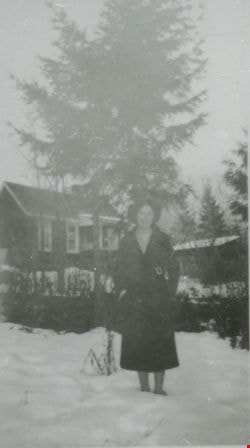
Evelyn Le Grove
https://search.heritageburnaby.ca/link/archivedescription38047
- Repository
- City of Burnaby Archives
- Date
- February 1933 (date of original), copied 1991
- Collection/Fonds
- Burnaby Historical Society fonds
- Description Level
- Item
- Physical Description
- 1 photograph : b&w ; 4.4 x 2.5 cm print on contact sheet 20.2 x 26.6 cm
- Scope and Content
- Photograph of Evelyn Le Grove at McGregor Avenue and Portland Street in the snow. A house can be seen in the background.
- Repository
- City of Burnaby Archives
- Date
- February 1933 (date of original), copied 1991
- Collection/Fonds
- Burnaby Historical Society fonds
- Subseries
- Burnaby Image Bank subseries
- Physical Description
- 1 photograph : b&w ; 4.4 x 2.5 cm print on contact sheet 20.2 x 26.6 cm
- Description Level
- Item
- Record No.
- 370-634
- Access Restriction
- No restrictions
- Reproduction Restriction
- No known restrictions
- Accession Number
- BHS1999-03
- Scope and Content
- Photograph of Evelyn Le Grove at McGregor Avenue and Portland Street in the snow. A house can be seen in the background.
- Names
- Le Grove, Evelyn Hardy
- Media Type
- Photograph
- Notes
- Title based on contents of photograph
- 1 b&w copy negative accompanying
- Negative has a pink cast
- Geographic Access
- McGregor Avenue
- Portland Street
- Historic Neighbourhood
- Alta-Vista (Historic Neighbourhood)
- Planning Study Area
- Sussex-Nelson Area
Images
![The Fair Haven, [between 1950 and 1957] thumbnail](/media/Hpo/_Data/_Archives_Images/_Unrestricted/251/305-001.jpg?width=280)
The Fair Haven
https://search.heritageburnaby.ca/link/archivedescription36597
- Repository
- City of Burnaby Archives
- Date
- [between 1950 and 1957]
- Collection/Fonds
- Burnaby Historical Society fonds
- Description Level
- Item
- Physical Description
- 1 photograph : col. postcard ; 9 x 14 cm
- Scope and Content
- Aerial photographic postcard of "the Fair Haven," a group of United Church homes for Senior Citizens. The road in the foreground is Rumble Street, and the long road to the right is Sussex Avenue. The small forest behind "the Fair Haven" is the David Gary Park.
- Repository
- City of Burnaby Archives
- Date
- [between 1950 and 1957]
- Collection/Fonds
- Burnaby Historical Society fonds
- Subseries
- Vera Jackson Pel subseries
- Physical Description
- 1 photograph : col. postcard ; 9 x 14 cm
- Description Level
- Item
- Record No.
- 305-001
- Access Restriction
- No restrictions
- Reproduction Restriction
- Reproduce for fair dealing purposes only
- Accession Number
- BHS1992-46
- Scope and Content
- Aerial photographic postcard of "the Fair Haven," a group of United Church homes for Senior Citizens. The road in the foreground is Rumble Street, and the long road to the right is Sussex Avenue. The small forest behind "the Fair Haven" is the David Gary Park.
- Subjects
- Aerial Photographs
- Documentary Artifacts - Postcards
- Buildings - Residential - Seniors Housing
- Names
- Fair Haven
- Media Type
- Photograph
- Notes
- Typewritten note on verso of postcard reads: "AERIAL VIEW/ 'The Fairhaven', Burnaby BC / United Church Homes for Senior Citizens / 4341 Rumble St., Burnaby, BC"
- Handwritten note on verso of postcard reads: ""The road in the foreground is Rumble Street. The long road to the right is Sussex Avenue. The road, going up, on the left, barely visible is McKay Avenue = lower corner. Behind Fair Haven is the future David Gary Park cleared in the late 1950's - then more trees were felled in October 1962 with Hurricane Freda (blown over, uprooted trees) that left the park as it is today in 1993. The top row of little (5) white cottages were moved from the N.W. corner of Willingdon and Kingsway where Old Orchard Mall is now - they were part of Old Orchard Auto Villas, the first Fair Havens. Note: All cottages on right side of Lodge have been moved to Vancouver Island in 1991 for Motel units - by barge."
- Printed on verso of postcard: "Traveltime product, made in Vancouver, Canada, by Grant-Mann Lithographers Ltd."
- Geographic Access
- Rumble Street
- Street Address
- 4341 Rumble Street
- Historic Neighbourhood
- Alta-Vista (Historic Neighbourhood)
- Planning Study Area
- Sussex-Nelson Area
Images
![The Fair Haven, [between 1950 and 1957] thumbnail](/media/Hpo/_Data/_Archives_Images/_Unrestricted/251/305-001.jpg)