Narrow Results By
Person / Organization
- Baker, Kathleen Holmes 1
- Coe, Patsy Speirs 1
- Digney, Andy 4
- Digney, Ernest Frank "Dig" 1
- Elizabeth, Queen, consort of George VI, King of Great Britain, 1900-2002 1
- Ellis, Jim 2
- Elllis, Jim 1
- Fowler, Rod 2
- George VI, King of Great Britain, 1895-1952 1
- Gray, Clamor 1
- Gray, Emily Christmas 2
- Gray, William "Bill" 1

Alta Vista Neighbourhood
https://search.heritageburnaby.ca/link/landmark707
- Repository
- Burnaby Heritage Planning
- Associated Dates
- 1925-1954
- Heritage Value
- As with many areas of Burnaby during this period, the years after World War Two marked a rapid growth in residential development in the Alta-Vista Neighbourhood. Subdivisions like Sussex and Suncrest were built and new schools and amenities were constructed to meet the demands of increased population.
- Historic Neighbourhood
- Alta Vista (Historic Neighbourhood)
- Planning Study Area
- Sussex-Nelson Area
Images


Alta Vista Neighbourhood
https://search.heritageburnaby.ca/link/landmark766
- Repository
- Burnaby Heritage Planning
- Associated Dates
- 1905-1924
- Heritage Value
- Alta Vista, named for its high views of the Fraser Valley, rapidly grew during the period 1910-1912, seeing its settlement jump from about a dozen buildings in 1910 to about four hundred by the end of 1912. Home-seekers were attracted to its location just a short walk from the B.C.E.R. line at Royal Oak and Highland Park and easily accessible to both New Westminster and Vancouver.
- Historic Neighbourhood
- Alta Vista (Historic Neighbourhood)
- Planning Study Area
- Sussex-Nelson Area
Images

![Burnaby Alderman, Bill (William) Lewarne, [1973]. Item no. 231-012 thumbnail](/media/hpo/_Data/_Archives_Images/_Unrestricted/205/231-012.jpg?width=280)
Interview with William A. Lewarne by Rod Fowler March 14, 1990 - Track 2
https://search.heritageburnaby.ca/link/oralhistory442
- Repository
- City of Burnaby Archives
- Date Range
- 1893-1944
- Length
- 00:05:35
- Summary
- This portion of the interview is about Bill Lewarne’s parents’ history (Ethel Leer and Alfred Lewarne) and growing up in South Burnaby.
- Repository
- City of Burnaby Archives
- Summary
- This portion of the interview is about Bill Lewarne’s parents’ history (Ethel Leer and Alfred Lewarne) and growing up in South Burnaby.
- Date Range
- 1893-1944
- Photo Info
- Burnaby Alderman, Bill (William) Lewarne, [1973]. Item no. 231-012
- Length
- 00:05:35
- Names
- Lewarne, Ethel Leer
- Historic Neighbourhood
- Alta-Vista (Historic Neighbourhood)
- Planning Study Area
- Sussex-Nelson Area
- Interviewer
- Fowler, Rod
- Interview Date
- March 14, 1990
- Scope and Content
- Recording is of an interview with former Mayor William “Bill” Lewarne, conducted by Rod Fowler. Bill Lewarne was one of eleven participants interviewed as part of the SFU/Burnaby Centennial Committee's oral history series titled, "Voices of Burnaby". The interview is mainly about Bill Lewarne’s business and political careers, and memories of growing up in South Burnaby in the 1930s. Bill Lewarne talks about his parent’s origins, his family and community struggles during the Depression, the interurban, his education, war service, and joining his father's business. He describes the start, operation and expansion of the family ice cream business, and how business life compared to political life. The interview explores the role of politics in community affairs, his political activities, the history of the BVA, and his involvement in various community organizations. To view “Narrow By” terms for each track, expand this description and see “Notes”.
- Biographical Notes
- William Alfred “Bill” Lewarne was born in Burnaby in 1926 to Ethel Cecilia Leer (1899- ) and Alfred Lewarne (1893-1962). The family, Ethel, Alfred and their three children Patricia, Beverley and William, moved to a house on Nelson Avenue in Alta Vista in 1931. Ethel still lived in the family home in 1990. Bill Lewarne attended Nelson Avenue School and South Burnaby High School (1932-1944). His father Alfred worked at Colony Farms as a dairy inspector and then for the Port of Vancouver Dairy before being laid off early in the Depression. The family struggled until in 1936 Alfred started his own ice cream business. After graduation Bill was in the army for two years, taking a refrigeration course under the veteran’s training benefit, before joining his father’s business. Three generations of the family operated the successful company, expanding from wholesale, retail and distribution of ice cream products into refrigerated warehouses and the wholesale ice business, until the business was sold to its competitor Dairyland in 1989. Bill Lewarne entered politics in 1965, first with the Nonpartisan Association (NPA) and then as a founder of the Burnaby Citizens Association (BCA). He served as an alderman on Burnaby Council 1973-1975 and 1977-1981 and as Mayor 1981-1987. In 1979 he ran for provincial office for the Social Credit Party against Rosemary Brown but lost. Bill Lewarne married June Lawrence and they had three children Robert, Leslie and Janice. He was active in many organizations: Burnaby/Willingdon Liberal Association, Seton Villa, Irish Fusileers of Canada, Lions Club, Rotary Club, Burnaby Association for Community Inclusion, and the Burnaby Hospital Foundation, and continued to be active on the Board of the BCA. Bill Lewarne died in 1995.
- Total Tracks
- 14
- Total Length
- 1:34:40
- Interviewee Name
- Lewarne, William A. "Bill"
- Interviewer Bio
- Rod Fowler returned to university as a mature student in the 1980s after working about twenty years in the field of economics and business computerization in England, Europe and Western Canada. He graduated with a BA from SFU in both History and Sociology in 1987, his MA degree in Geography in 1989, and his PhD in Cultural Geography at SFU. He taught courses in Geography, Sociology, History and Canadian Studies at several Lower Mainland colleges, before becoming a full time member of the Geography Department at Kwantlen University College.
- Collection/Fonds
- SFU/Burnaby Centennial Committee fonds
- Transcript Available
- Transcript available
- Media Type
- Sound Recording
- Web Notes
- Interviews were digitized in 2015 allowing them to be accessible on Heritage Burnaby. The digitization project was initiated by the Community Heritage Commission with support from City of Burnaby Council.
Images
![Burnaby Alderman, Bill (William) Lewarne, [1973]. Item no. 231-012 thumbnail](/media/hpo/_Data/_Archives_Images/_Unrestricted/205/231-012.jpg)
Audio Tracks
Track two of interview with Bill Lewarne
Track two of interview with Bill Lewarne
https://search.heritageburnaby.ca/media/hpo/_Data/_Archives_Oral_Histories/_Unrestricted/MSS187-019/MSS187-019_Track_2.mp3![O.G. Naud house, [1908] (date of original), copied 1986 thumbnail](/media/hpo/_Data/_Archives_Images/_Unrestricted/126/172-002-001.jpg?width=280)
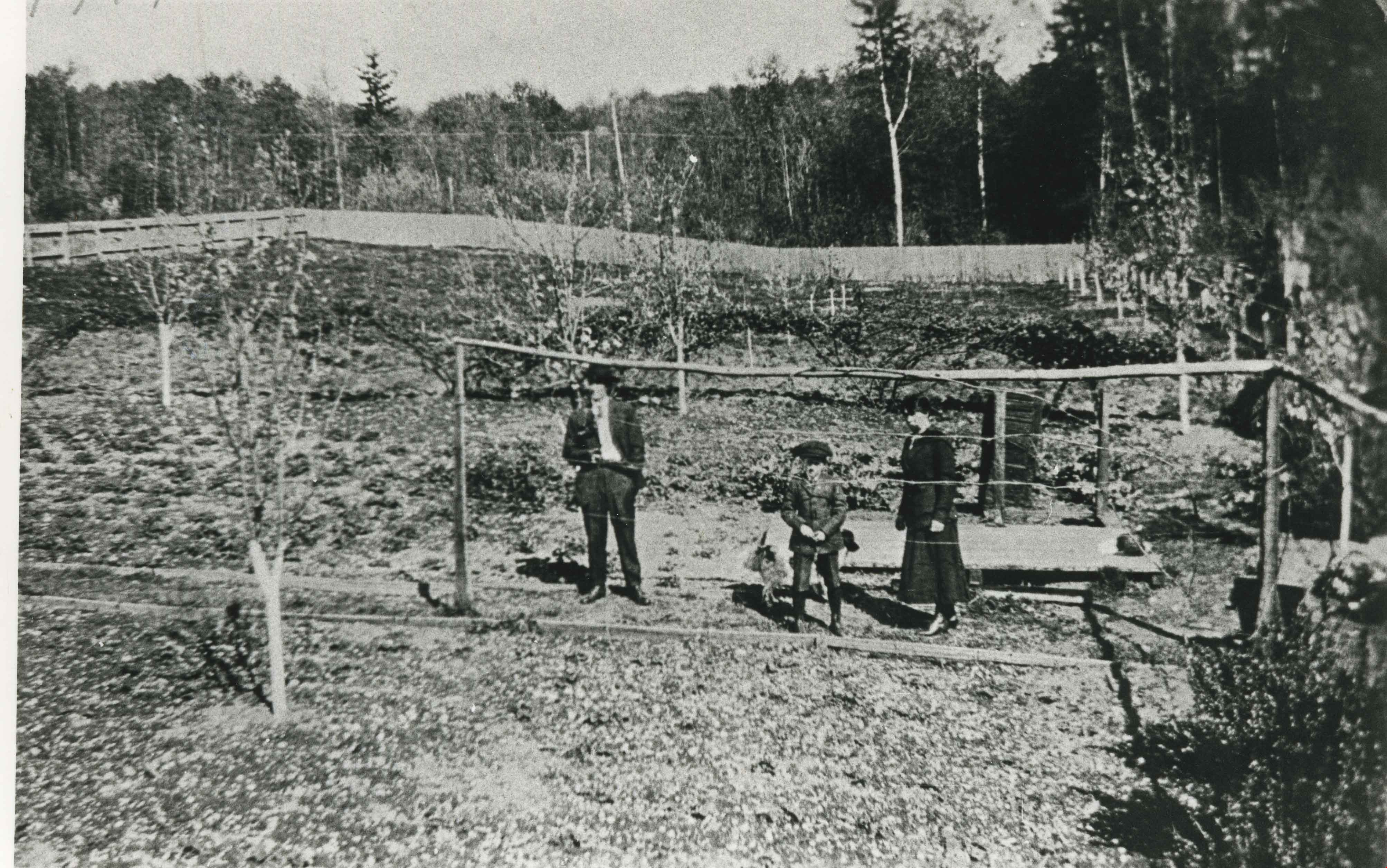
O.G. Naud house
https://search.heritageburnaby.ca/link/archivedescription35005
- Repository
- City of Burnaby Archives
- Date
- [1908] (date of original), copied 1986
- Collection/Fonds
- Burnaby Historical Society fonds
- Description Level
- Item
- Physical Description
- 1 photograph : b&w ; 8.8 x 12.5 cm print
- Scope and Content
- Photograph is the left side of a three-part panorama (photos 172-002a to 172-002c) of the land beside the house of Onezime G. Naud, 4737 Victory Road (later renamed Victory Street). A garden and a fence with a woman standing beside it can be seen.
- Repository
- City of Burnaby Archives
- Date
- [1908] (date of original), copied 1986
- Collection/Fonds
- Burnaby Historical Society fonds
- Subseries
- O.G. Naud subseries
- Physical Description
- 1 photograph : b&w ; 8.8 x 12.5 cm print
- Description Level
- Item
- Record No.
- 172-002-1
- Access Restriction
- No restrictions
- Reproduction Restriction
- No known restrictions
- Accession Number
- BHS1986-21
- Scope and Content
- Photograph is the left side of a three-part panorama (photos 172-002a to 172-002c) of the land beside the house of Onezime G. Naud, 4737 Victory Road (later renamed Victory Street). A garden and a fence with a woman standing beside it can be seen.
- Subjects
- Buildings - Residential - Houses
- Media Type
- Photograph
- Notes
- Title based on contents of photograph
- b&w ; 5.5 x 24.5 cm photocopy of entire panorama accompanying in accession file
- Geographic Access
- Victory Street
- Street Address
- 4737 Victory Street
- Historic Neighbourhood
- Alta-Vista (Historic Neighbourhood)
- Planning Study Area
- Sussex-Nelson Area
Images
![O.G. Naud house, [1908] (date of original), copied 1986 thumbnail](/media/hpo/_Data/_Archives_Images/_Unrestricted/126/172-002-001.jpg)
![O.G. Naud house, [1908] (date of original), copied 1986 thumbnail](/media/hpo/_Data/_Archives_Images/_Unrestricted/126/172-002-002.jpg?width=280)
O.G. Naud house
https://search.heritageburnaby.ca/link/archivedescription39831
- Repository
- City of Burnaby Archives
- Date
- [1908] (date of original), copied 1986
- Collection/Fonds
- Burnaby Historical Society fonds
- Description Level
- Item
- Physical Description
- 1 photograph : b&w ; 8.8 x 12.5 cm print
- Scope and Content
- Photograph is the centre of a three-part panorama (items no. 172-002a to 172-002c) of the house of Onezime G. Naud at 4737 Victory Road (later renamed Victory Street). A house and garden with a number of adults and children standing outside can be seen.
- Repository
- City of Burnaby Archives
- Date
- [1908] (date of original), copied 1986
- Collection/Fonds
- Burnaby Historical Society fonds
- Subseries
- O.G. Naud subseries
- Physical Description
- 1 photograph : b&w ; 8.8 x 12.5 cm print
- Description Level
- Item
- Record No.
- 172-002-2
- Access Restriction
- No restrictions
- Reproduction Restriction
- No known restrictions
- Accession Number
- BHS1986-21
- Scope and Content
- Photograph is the centre of a three-part panorama (items no. 172-002a to 172-002c) of the house of Onezime G. Naud at 4737 Victory Road (later renamed Victory Street). A house and garden with a number of adults and children standing outside can be seen.
- Subjects
- Buildings - Residential - Houses
- Media Type
- Photograph
- Notes
- Title based on contents of photograph
- b&w ; 5.5 x 24.5 cm photocopy of entire panorama accompanying in accession file
- Annotation on back of photo reads, "O.G. Naud House, Nelson Ave., c. 1910"
- Geographic Access
- Victory Street
- Street Address
- 4737 Victory Street
- Historic Neighbourhood
- Alta-Vista (Historic Neighbourhood)
- Planning Study Area
- Sussex-Nelson Area
Images
![O.G. Naud house, [1908] (date of original), copied 1986 thumbnail](/media/hpo/_Data/_Archives_Images/_Unrestricted/126/172-002-002.jpg)
![O.G. Naud house, [1908] (date of original), copied 1986 thumbnail](/media/hpo/_Data/_Archives_Images/_Unrestricted/126/172-002-003.jpg?width=280)
O.G. Naud house
https://search.heritageburnaby.ca/link/archivedescription39832
- Repository
- City of Burnaby Archives
- Date
- [1908] (date of original), copied 1986
- Collection/Fonds
- Burnaby Historical Society fonds
- Description Level
- Item
- Physical Description
- 1 photograph : b&w ; 8.8 x 12.5 cm print
- Scope and Content
- Photograph is the right side of a three-part panorama (photos 172-002a to 172-002c) showing the land beside the house of Onezime G. Naud at 4737 Victory Road (later renamed Victory Street). A number of adults and children are seen standing in a field.
- Repository
- City of Burnaby Archives
- Date
- [1908] (date of original), copied 1986
- Collection/Fonds
- Burnaby Historical Society fonds
- Subseries
- O.G. Naud subseries
- Physical Description
- 1 photograph : b&w ; 8.8 x 12.5 cm print
- Description Level
- Item
- Record No.
- 172-002-3
- Access Restriction
- No restrictions
- Reproduction Restriction
- No known restrictions
- Accession Number
- BHS1986-21
- Scope and Content
- Photograph is the right side of a three-part panorama (photos 172-002a to 172-002c) showing the land beside the house of Onezime G. Naud at 4737 Victory Road (later renamed Victory Street). A number of adults and children are seen standing in a field.
- Media Type
- Photograph
- Notes
- Title based on contents of photograph
- b&w ; 5.5 x 24.5 cm photocopy of entire panorama accompanying in accession file
- Geographic Access
- Victory Street
- Street Address
- 4737 Victory Street
- Historic Neighbourhood
- Alta-Vista (Historic Neighbourhood)
- Planning Study Area
- Sussex-Nelson Area
Images
![O.G. Naud house, [1908] (date of original), copied 1986 thumbnail](/media/hpo/_Data/_Archives_Images/_Unrestricted/126/172-002-003.jpg)

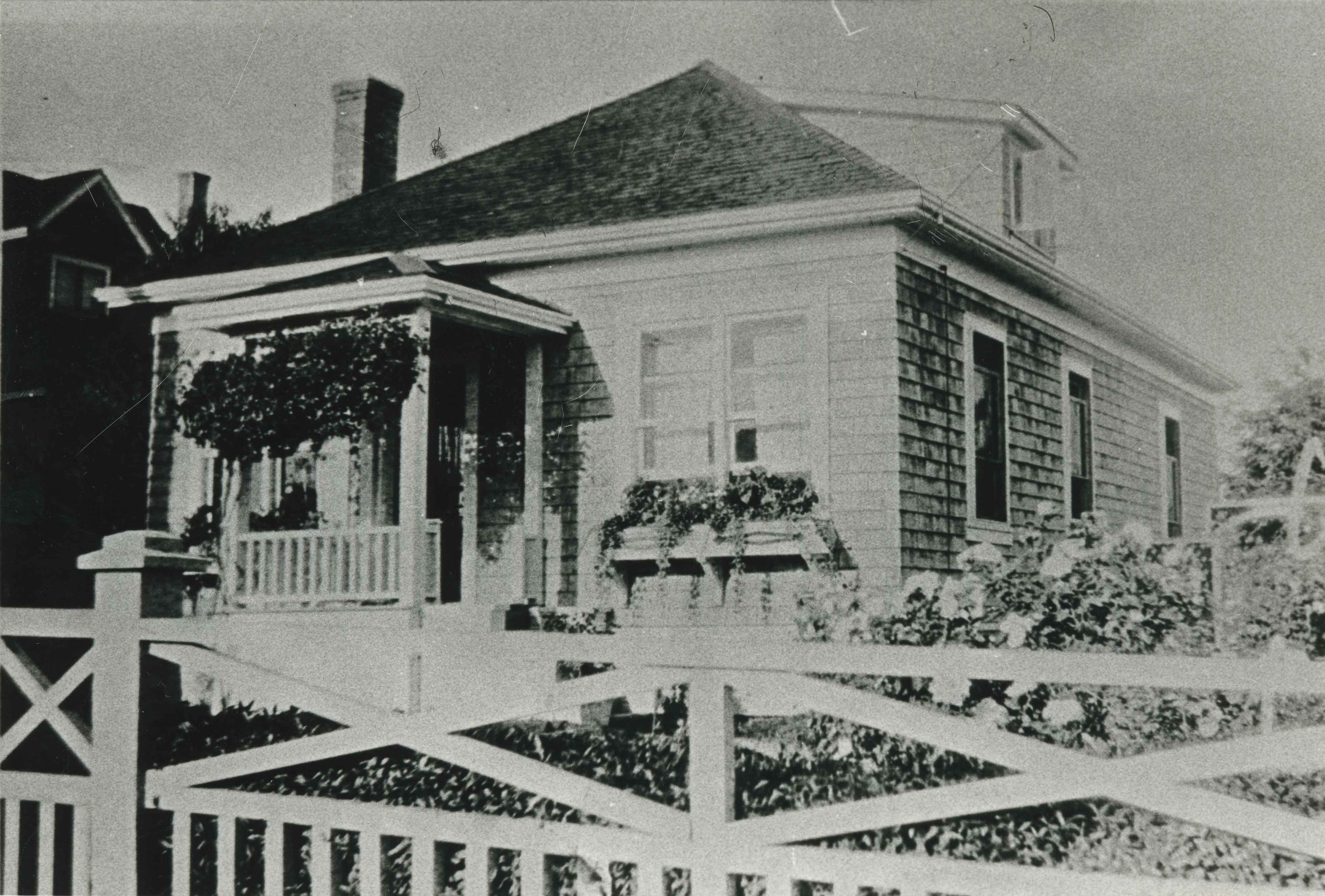
O.G. Naud House
https://search.heritageburnaby.ca/link/landmark509
- Repository
- Burnaby Heritage Planning
- Description
- The O.G. Naud House is a south facing, two-storey house with a bellcast hipped roof, set on a high basement. It features a double-height front verandah supported by classical columns. It is located on Victory Street in the Alta Vista neighbourhood of South Burnaby, and is one of the oldest houses i…
- Associated Dates
- 1908
- Formal Recognition
- Heritage Designation, Community Heritage Register
- Other Names
- Onezime & Charlsie Naud House
- Street View URL
- Google Maps Street View
- Repository
- Burnaby Heritage Planning
- Other Names
- Onezime & Charlsie Naud House
- Geographic Access
- Victory Street
- Associated Dates
- 1908
- Formal Recognition
- Heritage Designation, Community Heritage Register
- Enactment Type
- By-law No. 12316
- Enactment Date
- 26/05/2008
- Description
- The O.G. Naud House is a south facing, two-storey house with a bellcast hipped roof, set on a high basement. It features a double-height front verandah supported by classical columns. It is located on Victory Street in the Alta Vista neighbourhood of South Burnaby, and is one of the oldest houses in the area.
- Heritage Value
- Built in 1908, the O.G. Naud House is valued as one of the first houses to be built in the Alta Vista neighbourhood and is a direct link to the first settlement of the area. Close proximity to the B.C. Electric Railway streetcar line, at Royal Oak and Highland Park, permitted easy access to New Westminster and Vancouver. These transportation links, combined with spectacular views of the Fraser Valley, encouraged the early development of this South Burnaby neighbourhood. The O.G. Naud House is architecturally significant as an example of the influence of the Classical Revival style that had been popularized in Eastern Canada. The basic form of the house is a Foursquare, with a double-height verandah that dominates the symmetrically balanced façade, supported on lathe-turned columns. A central entry and regular fenestration further unify the façade composition. Construction employed locally available materials. The rough-cut foundation stone was harvested from boulders from the G. Ledingham property on the south side of Victory Street. The builder and first owner, Onezime George Naud (1858-1951), was originally from St. Albans, Quebec. He worked on railway construction in Alabama, where he met his wife, Charlsie Elizabeth Sims (1869-1974). He later took part in the 1898 Gold Rush in Atlin, then worked as a stonemason on CPR culverts and bridges across B.C. An accomplished stonemason, Naud also worked on the original Vancouver and New Westminster post offices, the Parliament buildings in Victoria, and the Capitol building in Olympia, Washington.
- Defining Elements
- The key characteristics that define the heritage character of the O.G. Naud House include its: - south-facing location, with generous set back from the street, in the Alta Vista neighbourhood of South Burnaby - residential form, scale and massing as expressed by its two-storey height plus full basement, bellcast hipped roof, rectangular plan and front projecting double-height verandah - masonry construction materials such as the rough-cut granite foundation - wood-frame construction, including lapped wooden siding and shingle siding extant under later cladding - Edwardian era features including lathe-turned columns, balustrades of dimensional lumber, scroll-cut bargeboards in front gable, and scroll-cut eave brackets - associated landscape features including lane access to the east, large cedar trees and perimeter plantings
- Historic Neighbourhood
- Alta Vista (Historic Neighbourhood)
- Planning Study Area
- Sussex-Nelson Area
- Function
- Primary Historic--Single Dwelling
- Community
- Alta Vista
- Cadastral Identifier
- P.I.D.003-100-375
- Boundaries
- The O.G. Naud House is comprised of a single residential lot located at 4737 Victory Street, Burnaby.
- Area
- 1099.47
- Contributing Resource
- Building
- Ownership
- Private
- Documentation
- City of Burnaby Planning and Building Department, Heritage Site Files
- Street Address
- 4737 Victory Street
- Street View URL
- Google Maps Street View
Images


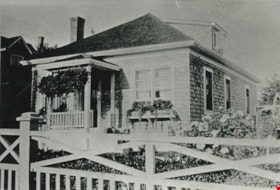
Gough family home
https://search.heritageburnaby.ca/link/archivedescription35491
- Repository
- City of Burnaby Archives
- Date
- 1920 (date of original), copied 1986
- Collection/Fonds
- Burnaby Historical Society fonds
- Description Level
- Item
- Physical Description
- 1 photograph : b&w ; 12.7 x 17.8 cm print
- Scope and Content
- Photograph of the Gough family home at 2119 Nelson Avenue (later 7126 Nelson Avenue). The house was built in 1912. William Gough was marble setter by trade, and he lived here with his wife, Agnes, and their children.
- Repository
- City of Burnaby Archives
- Date
- 1920 (date of original), copied 1986
- Collection/Fonds
- Burnaby Historical Society fonds
- Subseries
- Pioneer Tales subseries
- Physical Description
- 1 photograph : b&w ; 12.7 x 17.8 cm print
- Description Level
- Item
- Record No.
- 204-349
- Access Restriction
- No restrictions
- Reproduction Restriction
- No known restrictions
- Accession Number
- BHS1988-03
- Scope and Content
- Photograph of the Gough family home at 2119 Nelson Avenue (later 7126 Nelson Avenue). The house was built in 1912. William Gough was marble setter by trade, and he lived here with his wife, Agnes, and their children.
- Subjects
- Buildings - Residential - Houses
- Media Type
- Photograph
- Notes
- Title based on contents of photograph
- Geographic Access
- Nelson Avenue
- Street Address
- 2119 Nelson Avenue
- 7126 Nelson Avenue
- Historic Neighbourhood
- Alta-Vista (Historic Neighbourhood)
- Planning Study Area
- Sussex-Nelson Area
Images
![Gray family home, [192-] (date of original), copied 1986 thumbnail](/media/hpo/_Data/_Archives_Images/_Unrestricted/204/204-382.jpg?width=280)
Gray family home
https://search.heritageburnaby.ca/link/archivedescription35524
- Repository
- City of Burnaby Archives
- Date
- [192-] (date of original), copied 1986
- Collection/Fonds
- Burnaby Historical Society fonds
- Description Level
- Item
- Physical Description
- 1 photograph : b&w ; 12.7 x 17.8 cm print
- Scope and Content
- Photograph of the Gray family home finally completed at 4375 Winnifred Street. It was built in stages as money became available. The upstairs windows front the room where young William, an only child, slept. Winifred Street was named after Ernie North's sister, Winnifred North, who lived in Surrey…
- Repository
- City of Burnaby Archives
- Date
- [192-] (date of original), copied 1986
- Collection/Fonds
- Burnaby Historical Society fonds
- Subseries
- Pioneer Tales subseries
- Physical Description
- 1 photograph : b&w ; 12.7 x 17.8 cm print
- Description Level
- Item
- Record No.
- 204-382
- Access Restriction
- No restrictions
- Reproduction Restriction
- No known restrictions
- Accession Number
- BHS1988-03
- Scope and Content
- Photograph of the Gray family home finally completed at 4375 Winnifred Street. It was built in stages as money became available. The upstairs windows front the room where young William, an only child, slept. Winifred Street was named after Ernie North's sister, Winnifred North, who lived in Surrey, England.
- Subjects
- Buildings - Residential - Houses
- Media Type
- Photograph
- Notes
- Title based on contents of photograph
- Geographic Access
- Winnifred Street
- Street Address
- 4375 Winnifred Street
- Historic Neighbourhood
- Alta-Vista (Historic Neighbourhood)
- Planning Study Area
- Sussex-Nelson Area
Images
![Gray family home, [192-] (date of original), copied 1986 thumbnail](/media/hpo/_Data/_Archives_Images/_Unrestricted/204/204-382.jpg)
![Holmes family home, [1920] (date of original), copied 1986 thumbnail](/media/hpo/_Data/_Archives_Images/_Unrestricted/204/204-610.jpg?width=280)
Holmes family home
https://search.heritageburnaby.ca/link/archivedescription35752
- Repository
- City of Burnaby Archives
- Date
- [1920] (date of original), copied 1986
- Collection/Fonds
- Burnaby Historical Society fonds
- Description Level
- Item
- Physical Description
- 1 photograph : b&w ; 12.7 x 17.8 cm print
- Scope and Content
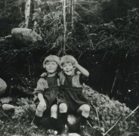
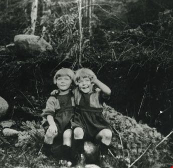
- Photograph of the Holmes family home, 3919 Watling Street (later renumbered 4527 Watling Street). This was the second house the family lived in. Identified (left to right) sisters Kathleen Holmes and Eileen Holmes.
- Repository
- City of Burnaby Archives
- Date
- [1920] (date of original), copied 1986
- Collection/Fonds
- Burnaby Historical Society fonds
- Subseries
- Pioneer Tales subseries
- Physical Description
- 1 photograph : b&w ; 12.7 x 17.8 cm print
- Description Level
- Item
- Record No.
- 204-610
- Access Restriction
- No restrictions
- Reproduction Restriction
- No known restrictions
- Accession Number
- BHS1988-03
- Scope and Content
- Photograph of the Holmes family home, 3919 Watling Street (later renumbered 4527 Watling Street). This was the second house the family lived in. Identified (left to right) sisters Kathleen Holmes and Eileen Holmes.
- Subjects
- Buildings - Residential - Houses
- Media Type
- Photograph
- Notes
- Title based on contents of photograph
- Geographic Access
- Watling Street
- Street Address
- 4527 Watling Street
- Historic Neighbourhood
- Alta-Vista (Historic Neighbourhood)
- Planning Study Area
- Sussex-Nelson Area
Images
![Holmes family home, [1920] (date of original), copied 1986 thumbnail](/media/hpo/_Data/_Archives_Images/_Unrestricted/204/204-610.jpg)
![Wray family house, [192-] thumbnail](/media/hpo/_Data/_BVM_Images/1985/1985_0439_0003_001.jpg?width=280)
Wray family house
https://search.heritageburnaby.ca/link/museumdescription216
- Repository
- Burnaby Village Museum
- Date
- [192-]
- Collection/Fonds
- Burnaby Village Museum Photograph collection
- Description Level
- Item
- Physical Description
- 1 photograph : b&w
- Scope and Content
- Photograph of the Wray family house located at 2351 Dow Road (old street number). Note the ladders and minor construction on the verandah. There are brambles, weeds and tall plants growing around the house.
- Repository
- Burnaby Village Museum
- Collection/Fonds
- Burnaby Village Museum Photograph collection
- Description Level
- Item
- Physical Description
- 1 photograph : b&w
- Material Details
- inscribed in pencil, verso, t. "Home of Mr + Mrs Edward Wray/ 2351 Dow Road. (with half/ of verandah filled in)", stamped upside down, l.r. "0020"
- The name "velox" is lightly printed on the back of the photo paper: thus, the photograph is printed on Kodak velox photo paper made in early 1900s for amateur photography.
- Scope and Content
- Photograph of the Wray family house located at 2351 Dow Road (old street number). Note the ladders and minor construction on the verandah. There are brambles, weeds and tall plants growing around the house.
- Subjects
- Buildings - Residential - Houses
- Geographic Access
- Dow Avenue
- Street Address
- 6926 Dow Avenue
- Accession Code
- BV985.439.3
- Date
- [192-]
- Media Type
- Photograph
- Historic Neighbourhood
- Alta-Vista (Historic Neighbourhood)
- Planning Study Area
- Sussex-Nelson Area
- Scan Resolution
- 600
- Scan Date
- 16-Jan-24
- Scale
- 100
- Notes
- Title based on contents of photograph
Images
![Wray family house, [192-] thumbnail](/media/hpo/_Data/_BVM_Images/1985/1985_0439_0003_001.jpg)
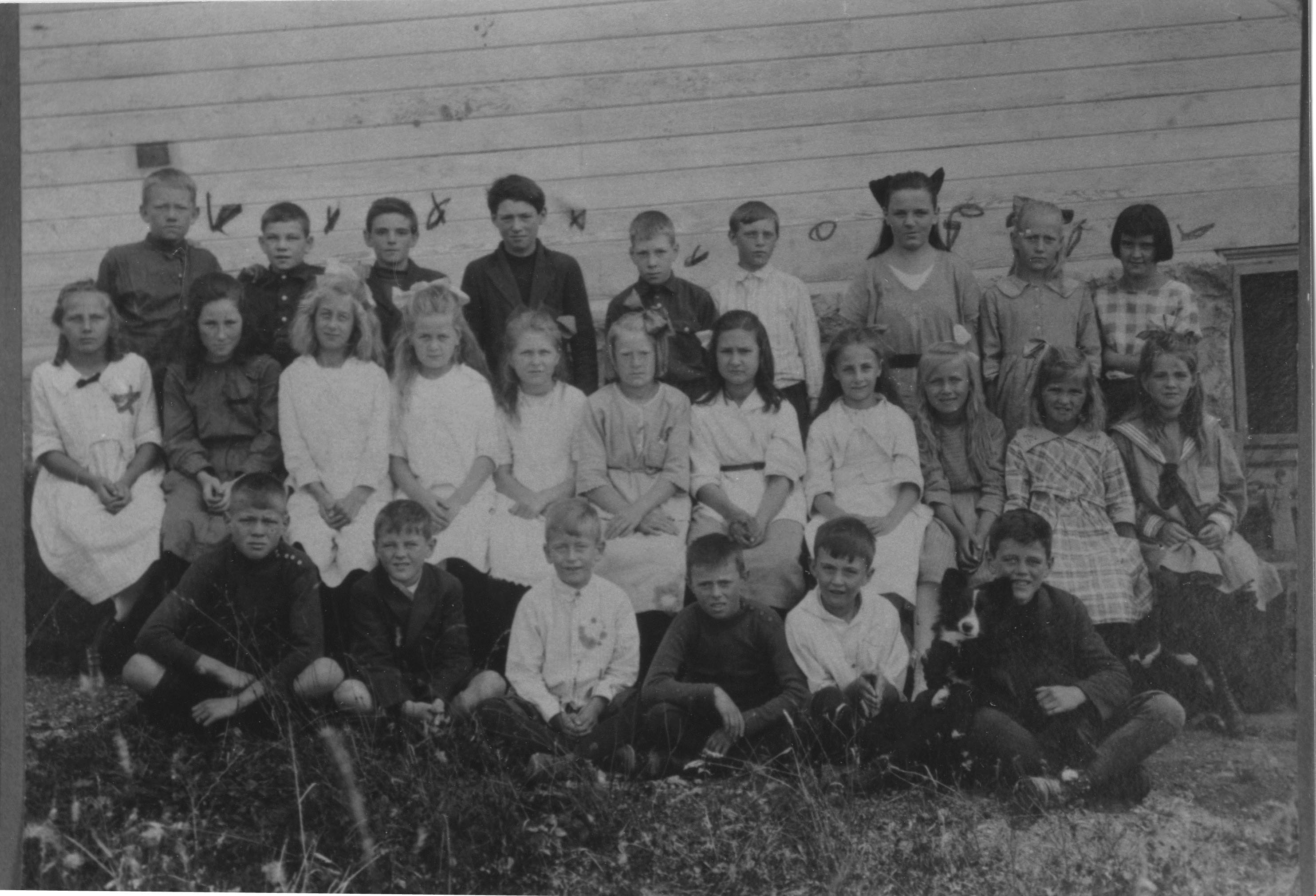
Boys and girls at Riverway West School
https://search.heritageburnaby.ca/link/archivedescription35988
- Repository
- City of Burnaby Archives
- Date
- 1921
- Collection/Fonds
- Burnaby Historical Society fonds
- Description Level
- Item
- Physical Description
- 1 photograph : b&w ; 8.5 x 12 cm print
- Scope and Content
- Photograph of a class of boys and girls at Riverway West School, standing and sitting outside in three rows. A border collie puppy is sitting on a boy's lap, in the first row, on the far right.
- Repository
- City of Burnaby Archives
- Date
- 1921
- Collection/Fonds
- Burnaby Historical Society fonds
- Subseries
- Edmonds School subseries
- Physical Description
- 1 photograph : b&w ; 8.5 x 12 cm print
- Description Level
- Item
- Record No.
- 207-037
- Access Restriction
- No restrictions
- Reproduction Restriction
- No known restrictions
- Accession Number
- BHS1988-07
- Scope and Content
- Photograph of a class of boys and girls at Riverway West School, standing and sitting outside in three rows. A border collie puppy is sitting on a boy's lap, in the first row, on the far right.
- Subjects
- Animals - Dogs
- Names
- Riverway West School
- Media Type
- Photograph
- Notes
- Title based on contents of photograph
- Geographic Access
- Marine Drive
- Street Address
- 4340 Marine Drive
- Historic Neighbourhood
- Alta-Vista (Historic Neighbourhood)
- Planning Study Area
- Sussex-Nelson Area
Images
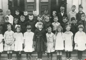
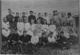
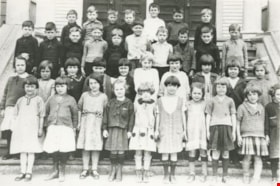
Nelson Avenue School Junior class
https://search.heritageburnaby.ca/link/archivedescription35506
- Repository
- City of Burnaby Archives
- Date
- 1922 (date of original), copied 1986
- Collection/Fonds
- Burnaby Historical Society fonds
- Description Level
- Item
- Physical Description
- 1 photograph : b&w ; 12.7 x 17.8 cm print
- Scope and Content
- Photograph of Nelson Avenue School, Junior class. Identified (2nd row, far right) Carlyle Le Grove (Lyle). Teacher: Miss R.I. Leavens. Lyle was the son of Ida Le Grove (nee Burlton) and Frederick Le Grove.
- Repository
- City of Burnaby Archives
- Date
- 1922 (date of original), copied 1986
- Collection/Fonds
- Burnaby Historical Society fonds
- Subseries
- Pioneer Tales subseries
- Physical Description
- 1 photograph : b&w ; 12.7 x 17.8 cm print
- Description Level
- Item
- Record No.
- 204-364
- Access Restriction
- No restrictions
- Reproduction Restriction
- No known restrictions
- Accession Number
- BHS1988-03
- Scope and Content
- Photograph of Nelson Avenue School, Junior class. Identified (2nd row, far right) Carlyle Le Grove (Lyle). Teacher: Miss R.I. Leavens. Lyle was the son of Ida Le Grove (nee Burlton) and Frederick Le Grove.
- Media Type
- Photograph
- Notes
- Title based on contents of photograph
- Geographic Access
- Irmin Street
- Street Address
- 4850 Irmin Street
- Historic Neighbourhood
- Alta-Vista (Historic Neighbourhood)
- Planning Study Area
- Sussex-Nelson Area
Images
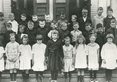
Nelson Street School Grade 5 class
https://search.heritageburnaby.ca/link/archivedescription37305
- Repository
- City of Burnaby Archives
- Date
- 1923
- Collection/Fonds
- Burnaby Historical Society fonds
- Description Level
- Item
- Physical Description
- 1 photograph : b&w ; 11 x 16 cm
- Scope and Content
- Photograph of thirty-five students in the grade 5 class from Nelson Avenue School, outside the school building. A note with the photograph indicates that the teacher was Marion E. Lawrence (not in photograph).
- Repository
- City of Burnaby Archives
- Date
- 1923
- Collection/Fonds
- Burnaby Historical Society fonds
- Subseries
- Jim Wolf subseries
- Physical Description
- 1 photograph : b&w ; 11 x 16 cm
- Description Level
- Item
- Record No.
- 349-001
- Access Restriction
- No restrictions
- Reproduction Restriction
- No known restrictions
- Accession Number
- BHS1997-09
- Scope and Content
- Photograph of thirty-five students in the grade 5 class from Nelson Avenue School, outside the school building. A note with the photograph indicates that the teacher was Marion E. Lawrence (not in photograph).
- Names
- Nelson Avenue School
- Media Type
- Photograph
- Notes
- Title based on contents of photograph
- Geographic Access
- Irmin Street
- Street Address
- 4850 Irmin Street
- Historic Neighbourhood
- Alta-Vista (Historic Neighbourhood)
- Planning Study Area
- Sussex-Nelson Area
Images

![Child's homemade driveable toy car, [1923] thumbnail](/media/hpo/_Data/_Archives_Images/_Unrestricted/370/370-337.jpg?width=280)
Child's homemade driveable toy car
https://search.heritageburnaby.ca/link/archivedescription37749
- Repository
- City of Burnaby Archives
- Date
- [1923]
- Collection/Fonds
- Burnaby Historical Society fonds
- Description Level
- Item
- Physical Description
- 1 photograph : b&w ; 2.6 x 4.5 cm prints on contact sheet 20.3 x 26.6 cm
- Scope and Content
- Photograph of a child's homemade driveable toy car, in the backyard of 2313 Nelson Avenue (later renumbered 6926 Nelson Avenue).
- Repository
- City of Burnaby Archives
- Date
- [1923]
- Collection/Fonds
- Burnaby Historical Society fonds
- Subseries
- Burnaby Image Bank subseries
- Physical Description
- 1 photograph : b&w ; 2.6 x 4.5 cm prints on contact sheet 20.3 x 26.6 cm
- Description Level
- Item
- Record No.
- 370-337
- Access Restriction
- No restrictions
- Reproduction Restriction
- No known restrictions
- Accession Number
- BHS1999-03
- Scope and Content
- Photograph of a child's homemade driveable toy car, in the backyard of 2313 Nelson Avenue (later renumbered 6926 Nelson Avenue).
- Subjects
- Toys
- Transportation - Automobiles
- Media Type
- Photograph
- Notes
- Title based on contents of photograph
- 1 b&w copy negative accompanying
- Negative has a pink cast
- Geographic Access
- Nelson Avenue
- Street Address
- 6926 Nelson Avenue
- Historic Neighbourhood
- Central Park (Historic Neighbourhood)
- Planning Study Area
- Sussex-Nelson Area
Images
![Child's homemade driveable toy car, [1923] thumbnail](/media/hpo/_Data/_Archives_Images/_Unrestricted/370/370-337.jpg)
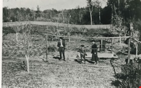
Gray Orchard
https://search.heritageburnaby.ca/link/archivedescription35521
- Repository
- City of Burnaby Archives
- Date
- 1924 (date of original), copied 1986
- Collection/Fonds
- Burnaby Historical Society fonds
- Description Level
- Item
- Physical Description
- 1 photograph : b&w ; 12.7 x 17.8 cm print
- Scope and Content
- Photograph of the Gray orchard on the south side of Winnifred Street. (From left) Clamor Gray (father of William Gray), Emily Gray (mother), and William Gray. Note the split cedar fencing all around the orchard to keep out animals.
- Repository
- City of Burnaby Archives
- Date
- 1924 (date of original), copied 1986
- Collection/Fonds
- Burnaby Historical Society fonds
- Subseries
- Pioneer Tales subseries
- Physical Description
- 1 photograph : b&w ; 12.7 x 17.8 cm print
- Description Level
- Item
- Record No.
- 204-379
- Access Restriction
- No restrictions
- Reproduction Restriction
- No known restrictions
- Accession Number
- BHS1988-03
- Scope and Content
- Photograph of the Gray orchard on the south side of Winnifred Street. (From left) Clamor Gray (father of William Gray), Emily Gray (mother), and William Gray. Note the split cedar fencing all around the orchard to keep out animals.
- Subjects
- Agriculture - Orchards
- Media Type
- Photograph
- Notes
- Title based on contents of photograph
- Geographic Access
- Winnifred Street
- Street Address
- 4375 Winnifred Street
- Historic Neighbourhood
- Alta-Vista (Historic Neighbourhood)
- Planning Study Area
- Sussex-Nelson Area
Images
Gray family garden
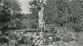
https://search.heritageburnaby.ca/link/archivedescription35522
- Repository
- City of Burnaby Archives
- Date
- 1924 (date of original), copied 1986
- Collection/Fonds
- Burnaby Historical Society fonds
- Description Level
- Item
- Physical Description
- 1 photograph : b&w ; 12.7 x 17.8 cm print
- Scope and Content
- Photograph of Emily Gray (mother of William Gray) in her garden on the south side of Winnifred Street. There was a spring, a pond with gold fish, guppies and lily pads, and flowers.
- Repository
- City of Burnaby Archives
- Date
- 1924 (date of original), copied 1986
- Collection/Fonds
- Burnaby Historical Society fonds
- Subseries
- Pioneer Tales subseries
- Physical Description
- 1 photograph : b&w ; 12.7 x 17.8 cm print
- Description Level
- Item
- Record No.
- 204-380
- Access Restriction
- No restrictions
- Reproduction Restriction
- No known restrictions
- Accession Number
- BHS1988-03
- Scope and Content
- Photograph of Emily Gray (mother of William Gray) in her garden on the south side of Winnifred Street. There was a spring, a pond with gold fish, guppies and lily pads, and flowers.
- Subjects
- Geographic Features - Gardens
- Names
- Gray, Emily Christmas
- Media Type
- Photograph
- Notes
- Title based on contents of photograph
- Geographic Access
- Winnifred Street
- Street Address
- 4375 Winnifred Street
- Historic Neighbourhood
- Alta-Vista (Historic Neighbourhood)
- Planning Study Area
- Sussex-Nelson Area
Images

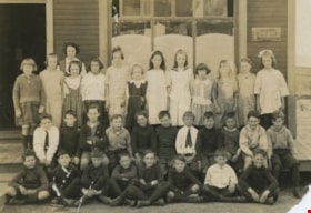
Nelson Avenue class
https://search.heritageburnaby.ca/link/archivedescription35207
- Repository
- City of Burnaby Archives
- Date
- 1925
- Collection/Fonds
- Burnaby Historical Society fonds
- Description Level
- Item
- Physical Description
- 1 photograph : b&w ; 12.7 x 17.8 cm print
- Scope and Content
- Photograph of Nelson Avenue School Grade 2 class. Margaret Neville is on the far left of the first row. She later married Dugald C. Patterson. The school is located at the corner of Nelson Avenue and Rumble Street.
- Repository
- City of Burnaby Archives
- Date
- 1925
- Collection/Fonds
- Burnaby Historical Society fonds
- Subseries
- Pioneer Tales subseries
- Physical Description
- 1 photograph : b&w ; 12.7 x 17.8 cm print
- Description Level
- Item
- Record No.
- 204-064
- Access Restriction
- No restrictions
- Reproduction Restriction
- No known restrictions
- Accession Number
- BHS1988-03
- Scope and Content
- Photograph of Nelson Avenue School Grade 2 class. Margaret Neville is on the far left of the first row. She later married Dugald C. Patterson. The school is located at the corner of Nelson Avenue and Rumble Street.
- Media Type
- Photograph
- Notes
- Title based on contents of photograph
- Geographic Access
- Irmin Street
- Street Address
- 4850 Irmin Street
- Historic Neighbourhood
- Alta-Vista (Historic Neighbourhood)
- Planning Study Area
- Sussex-Nelson Area
Images

Cutting down a Christmas tree
https://search.heritageburnaby.ca/link/archivedescription35382
- Repository
- City of Burnaby Archives
- Date
- 1925
- Collection/Fonds
- Burnaby Historical Society fonds
- Description Level
- Item
- Physical Description
- 1 photograph : b&w ; 12.7 x 17.8 cm print
- Scope and Content
- Photograph of twin sisters, Kay and Evelyn Rorison, cutting down a Christmas tree. Kay and Evelyn were the daughters of William and Alma Rorison of 3907 River Road (later becoming 4593 Marine Drive at Strathern Avenue).
- Repository
- City of Burnaby Archives
- Date
- 1925
- Collection/Fonds
- Burnaby Historical Society fonds
- Subseries
- Pioneer Tales subseries
- Physical Description
- 1 photograph : b&w ; 12.7 x 17.8 cm print
- Description Level
- Item
- Record No.
- 204-239
- Access Restriction
- No restrictions
- Reproduction Restriction
- No known restrictions
- Accession Number
- BHS1988-03
- Scope and Content
- Photograph of twin sisters, Kay and Evelyn Rorison, cutting down a Christmas tree. Kay and Evelyn were the daughters of William and Alma Rorison of 3907 River Road (later becoming 4593 Marine Drive at Strathern Avenue).
- Subjects
- Plants - Trees
- Media Type
- Photograph
- Notes
- Title based on contents of photograph
- Geographic Access
- Marine Drive
- Street Address
- 4593 Marine Drive
- Historic Neighbourhood
- Fraser Arm (Historic Neighbourhood)
- Planning Study Area
- Sussex-Nelson Area
Images
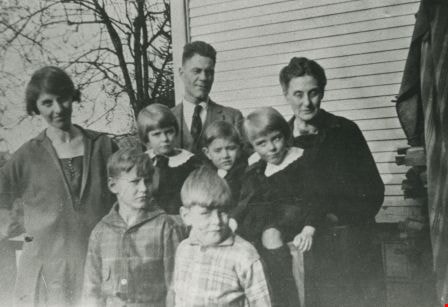
Rorison family
https://search.heritageburnaby.ca/link/archivedescription35380
- Repository
- City of Burnaby Archives
- Date
- 1926 (date of original), copied 1986
- Collection/Fonds
- Burnaby Historical Society fonds
- Description Level
- Item
- Physical Description
- 1 photograph : b&w ; 12.7 x 17.8 cm print
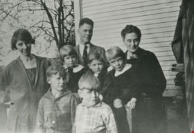
- Scope and Content
- Photograph of the William Rorison family. Front, left to right: Bill Rorison and Hugh Rorison. Middle, left to right: Alma Rorison, Kay Rorison, John Rorison, and Evelyn Rorison. Back, left to right: William Rorison and "Grandma" Cropley.
- Repository
- City of Burnaby Archives
- Date
- 1926 (date of original), copied 1986
- Collection/Fonds
- Burnaby Historical Society fonds
- Subseries
- Pioneer Tales subseries
- Physical Description
- 1 photograph : b&w ; 12.7 x 17.8 cm print
- Description Level
- Item
- Record No.
- 204-237
- Access Restriction
- No restrictions
- Reproduction Restriction
- No known restrictions
- Accession Number
- BHS1988-03
- Scope and Content
- Photograph of the William Rorison family. Front, left to right: Bill Rorison and Hugh Rorison. Middle, left to right: Alma Rorison, Kay Rorison, John Rorison, and Evelyn Rorison. Back, left to right: William Rorison and "Grandma" Cropley.
- Names
- Rorison, Alma
- Rorison, Bill
- Rorison, Evelyn
- Rorison, Hugh
- Rorison, Kay
- Rorison, John
- Rorison, William
- Media Type
- Photograph
- Notes
- Title based on contents of photograph
- Geographic Access
- Marine Drive
- Street Address
- 4593 Marine Drive
- Historic Neighbourhood
- Fraser Arm (Historic Neighbourhood)
- Planning Study Area
- Sussex-Nelson Area
Images