Narrow Results By
Subject
- Buildings - Recreational - Sports 1
- Buildings - Residential 1
- Buildings - Residential - Cabins 2
- Buildings - Residential - Houses 1
- Buildings - Residential - Townhouses 1
- Construction 1
- Geographic Features - Athletic Fields 1
- Geographic Features - Lakes and Ponds 1
- Natural Phenomena - Fires 1
- Occupations - Fire Fighters 1
- Occupations - Land Surveyors 1
- Occupations - Photographers 1
Surveyor field book 32
https://search.heritageburnaby.ca/link/museumdescription19633
- Repository
- Burnaby Village Museum
- Date
- 1913-1929, predominant 1913
- Collection/Fonds
- Burnaby Village Museum Map collection
- Description Level
- Item
- Physical Description
- 1 notebook
- Scope and Content
- Item consists of a field notebook with surveyor's field notes created by B.C. Land Surveyor, Walter Wilkie. Field notes include pertinent information, calculations, sketches and observations including geographic areas in Burnaby (D.L.86 and D.L. 136); Surrey (Twp 1, Twp 7); Maple Ridge (Twp 12); La…
- Repository
- Burnaby Village Museum
- Collection/Fonds
- Burnaby Village Museum Map collection
- Description Level
- Item
- Physical Description
- 1 notebook
- Material Details
- Yellow leather hardcover book with inscription on cover "FIELD BOOK";Technical Manufacturing & Supply Co., Vancouver, B.C.
- Annotation in black ink on front cover reads: "32"
- Includes reference tables at front and back of notebook for surveying computations.
- Scope and Content
- Item consists of a field notebook with surveyor's field notes created by B.C. Land Surveyor, Walter Wilkie. Field notes include pertinent information, calculations, sketches and observations including geographic areas in Burnaby (D.L.86 and D.L. 136); Surrey (Twp 1, Twp 7); Maple Ridge (Twp 12); Langley (Twp 10, Twp 11 and Lots 36, 304, 308, 309, 312); Dewdney (D.L. 484 Group 1) and Coquitlam (D.L.366 Group 1). Notebook includes a handwritten index of surveying content, on the last few pages at back of book.
- Creator
- Wilkie, "Walter" Gerald
- Subjects
- Occupations - Land Surveyors
- Accession Code
- HV977.128.1
- Access Restriction
- No restrictions
- Reproduction Restriction
- No known restrictions
- Date
- 1913-1929, predominant 1913
- Media Type
- Textual Record
- Notes
- Title based on contents of item
![Collision Plus Exclusive Auto Body fire, [2004] thumbnail](/media/hpo/_Data/_Archives_Images/_Unrestricted/535/535-1740.jpg?width=280)
Collision Plus Exclusive Auto Body fire
https://search.heritageburnaby.ca/link/archivedescription95989
- Repository
- City of Burnaby Archives
- Date
- [2004]
- Collection/Fonds
- Burnaby NewsLeader photograph collection
- Description Level
- Item
- Physical Description
- 1 photograph (tiff) : col.
- Scope and Content
- Photograph of Captain Mark Fletcher of the Burnaby Fire Department outside of the burned-out garage at the Collision Plus Exclusive Auto Body. An employee of the auto shop stands next to Fletcher and they are surveying the damage.
- Repository
- City of Burnaby Archives
- Date
- [2004]
- Collection/Fonds
- Burnaby NewsLeader photograph collection
- Physical Description
- 1 photograph (tiff) : col.
- Description Level
- Item
- Record No.
- 535-1740
- Access Restriction
- No restrictions
- Reproduction Restriction
- No restrictions
- Accession Number
- 2018-12
- Scope and Content
- Photograph of Captain Mark Fletcher of the Burnaby Fire Department outside of the burned-out garage at the Collision Plus Exclusive Auto Body. An employee of the auto shop stands next to Fletcher and they are surveying the damage.
- Names
- Burnaby Fire Department
- Media Type
- Photograph
- Photographer
- Bartel, Mario
- Notes
- Title based on caption
- Collected by editorial for use in a January 2004 issue of the Burnaby NewsLeader
- Caption from metadata: "Captain Mark Fletcher, of the Burnaby Fire Department, and Mickey Reale, the manager at Collision Plus Auto Body on Edmonds St., survey the damage after an early morning fire destroyed three cars in the shop garage."
- Geographic Access
- Edmonds Street
Images
![Collision Plus Exclusive Auto Body fire, [2004] thumbnail](/media/hpo/_Data/_Archives_Images/_Unrestricted/535/535-1740.jpg)
Letter re Special Survey of District Lots 9, 55, 106 and 107
https://search.heritageburnaby.ca/link/museumdescription11144
- Repository
- Burnaby Village Museum
- Date
- December 1927
- Collection/Fonds
- Ronald G. Scobbie collection
- Description Level
- Item
- Physical Description
- 1 p. of textual records
- Scope and Content
- Item consists of a letter dated 13th December 1927 with letterhead "McQuarrie, Whiteside & Duncan / Barristers & Solicitors", "New Westminster Office / Westminster Trust Building / Mission City Office / Catherwood Building / New Westminster, B.C.."; addressee "Messrs. Burnett & McGugan, Surveyors /…
- Repository
- Burnaby Village Museum
- Collection/Fonds
- Ronald G. Scobbie collection
- Description Level
- Item
- Physical Description
- 1 p. of textual records
- Scope and Content
- Item consists of a letter dated 13th December 1927 with letterhead "McQuarrie, Whiteside & Duncan / Barristers & Solicitors", "New Westminster Office / Westminster Trust Building / Mission City Office / Catherwood Building / New Westminster, B.C.."; addressee "Messrs. Burnett & McGugan, Surveyors / 30 McKenzie Street, CITY" "ATTENTION MR. BURNETT."; "Re: Special Survey of District Lots 9, 55, 106 and 107. Group 1, New Westminster District, District of Coquitlam".
- Accession Code
- BV003.83.23
- Access Restriction
- No restrictions
- Reproduction Restriction
- No known restrictions
- Date
- December 1927
- Media Type
- Textual Record
- Notes
- Title based on contents of item
Letter re Special Survey of District Lots 9, 55 (or 54) 106 and 107
https://search.heritageburnaby.ca/link/museumdescription11146
- Repository
- Burnaby Village Museum
- Date
- Dec. 5, 1927
- Collection/Fonds
- Ronald G. Scobbie collection
- Description Level
- Item
- Physical Description
- 1 p. of textual records
- Scope and Content
- Item consists of a typewritten letter dated December 5, 1927, addressee "R.C. McDonald, Esq., New Westminster, B.C.". "Re. Special Survey of District Lots 9, 55 (or 54) 106 and 107, Group 1, N.W.D." from Burnett & McGguan.
- Repository
- Burnaby Village Museum
- Collection/Fonds
- Ronald G. Scobbie collection
- Description Level
- Item
- Physical Description
- 1 p. of textual records
- Scope and Content
- Item consists of a typewritten letter dated December 5, 1927, addressee "R.C. McDonald, Esq., New Westminster, B.C.". "Re. Special Survey of District Lots 9, 55 (or 54) 106 and 107, Group 1, N.W.D." from Burnett & McGguan.
- Accession Code
- BV003.83.25
- Access Restriction
- No restrictions
- Reproduction Restriction
- No known restrictions
- Date
- Dec. 5, 1927
- Media Type
- Textual Record
- Notes
- Title based on contents of item

Arthur Francis Peers
https://search.heritageburnaby.ca/link/archivedescription34492
- Repository
- City of Burnaby Archives
- Date
- 1925
- Collection/Fonds
- Burnaby Historical Society fonds
- Description Level
- Item
- Physical Description
- 1 photograph : sepia ; 7.8 x 13.5 cm on page 17.5 x 26.4 cm
- Scope and Content
- Photograph of Arthur Francis Peers on a raft on Texas Lake. Arthur Peers, later of the Royal Canadian Navy and Order of the British Empire worked on the surveys for the construction of the Trans-Provincial Highway during the late 1920s and documented a lot of the work through his photographs.
- Repository
- City of Burnaby Archives
- Date
- 1925
- Collection/Fonds
- Burnaby Historical Society fonds
- Subseries
- Peers family subseries
- Physical Description
- 1 photograph : sepia ; 7.8 x 13.5 cm on page 17.5 x 26.4 cm
- Description Level
- Item
- Record No.
- 020-199
- Access Restriction
- No restrictions
- Reproduction Restriction
- No known restrictions
- Accession Number
- BHS2007-04
- Scope and Content
- Photograph of Arthur Francis Peers on a raft on Texas Lake. Arthur Peers, later of the Royal Canadian Navy and Order of the British Empire worked on the surveys for the construction of the Trans-Provincial Highway during the late 1920s and documented a lot of the work through his photographs.
- Media Type
- Photograph
- Notes
- Title based on caption accompanying photograph
Images

Cabins at Cottonwood Flats Camp
https://search.heritageburnaby.ca/link/archivedescription34476
- Repository
- City of Burnaby Archives
- Date
- 1927
- Collection/Fonds
- Burnaby Historical Society fonds
- Description Level
- Item
- Physical Description
- 1 photograph : sepia ; 6.7 x 12 cm on page 17.5 x 26 cm
- Scope and Content
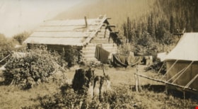
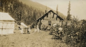
- Photograph of a clothesline strung between a log cabin and a white tent, holding a number of blankets and other articles of clothing. A caption accompanying the photograph reads: "Cottonwood Flats camp" and a note pasted next to the picture reads: "Survey work on Yellowhead Pass Highway." This pho…
- Repository
- City of Burnaby Archives
- Date
- 1927
- Collection/Fonds
- Burnaby Historical Society fonds
- Subseries
- Peers family subseries
- Physical Description
- 1 photograph : sepia ; 6.7 x 12 cm on page 17.5 x 26 cm
- Description Level
- Item
- Record No.
- 020-183
- Access Restriction
- No restrictions
- Reproduction Restriction
- No known restrictions
- Accession Number
- BHS2007-04
- Scope and Content
- Photograph of a clothesline strung between a log cabin and a white tent, holding a number of blankets and other articles of clothing. A caption accompanying the photograph reads: "Cottonwood Flats camp" and a note pasted next to the picture reads: "Survey work on Yellowhead Pass Highway." This photograph appears to have been taken by Arthur Peers, who travelled through the Fraser River Valley and worked on the construction of the Trans-Provincial Highway during the later 1920s.
- Media Type
- Photograph
- Photographer
- Peers, Arthur Francis "Mike"
- Notes
- Title based on caption accompanying photograph
Images
Cottonwood Flats Camps
https://search.heritageburnaby.ca/link/archivedescription34475
- Repository
- City of Burnaby Archives
- Date
- 1927
- Collection/Fonds
- Burnaby Historical Society fonds
- Description Level
- Item
- Physical Description
- 1 photograph : sepia ; 6.9 x 12 cm on page 17.5 x 26 cm
- Scope and Content
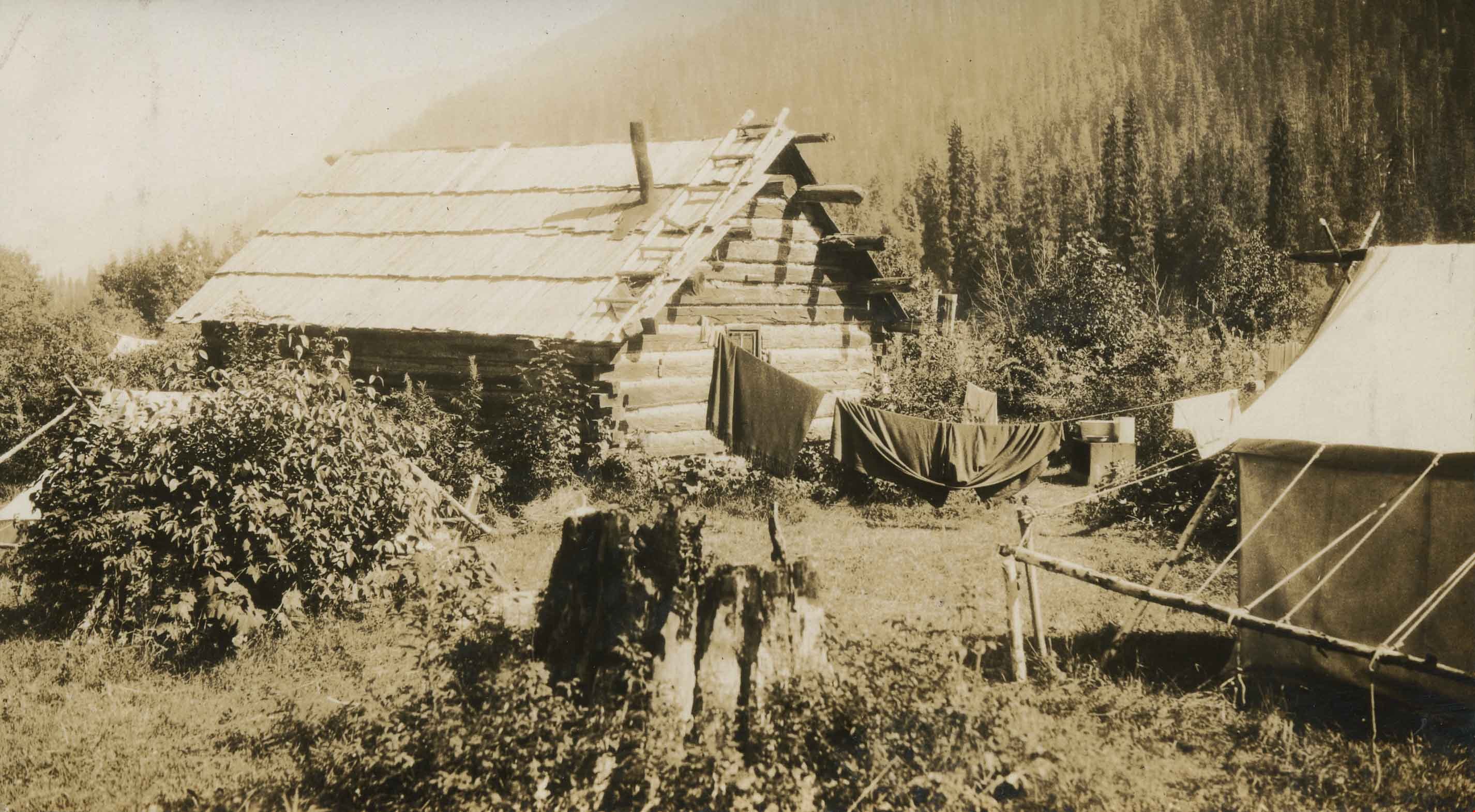
- Photograph of a log cabin and white tent erected in a field. A clothesline can be seen strung up outside the cabin with blankets handing to dry. A caption accompanying the photograph reads: "Cottonwood Flats camp" and a note pasted next to the picture reads: "Survey work on Yellowhead Pass Highwa…
- Repository
- City of Burnaby Archives
- Date
- 1927
- Collection/Fonds
- Burnaby Historical Society fonds
- Subseries
- Peers family subseries
- Physical Description
- 1 photograph : sepia ; 6.9 x 12 cm on page 17.5 x 26 cm
- Description Level
- Item
- Record No.
- 020-182
- Access Restriction
- No restrictions
- Reproduction Restriction
- No known restrictions
- Accession Number
- BHS2007-04
- Scope and Content
- Photograph of a log cabin and white tent erected in a field. A clothesline can be seen strung up outside the cabin with blankets handing to dry. A caption accompanying the photograph reads: "Cottonwood Flats camp" and a note pasted next to the picture reads: "Survey work on Yellowhead Pass Highway." This photograph appears to have been taken by Arthur Peers, who travelled through the Fraser River Valley and worked on the construction of the Trans-Provincial Highway during the later 1920s.
- Media Type
- Photograph
- Photographer
- Peers, Arthur Francis "Mike"
- Notes
- Title based on caption accompanying photograph
Images

![Don Brown at Bonsor, [2002] thumbnail](/media/hpo/_Data/_Archives_Images/_Unrestricted/535/535-2778.jpg?width=280)
Don Brown at Bonsor
https://search.heritageburnaby.ca/link/archivedescription97403
- Repository
- City of Burnaby Archives
- Date
- [2002]
- Collection/Fonds
- Burnaby NewsLeader photograph collection
- Description Level
- Item
- Physical Description
- 1 photograph (tiff) : col.
- Scope and Content
- Photograph of Don Brown posing against a playing field's fence. The Bonsor Recreation Complex, where the South Burnaby Metro Club is based, and neighbouring office and apartment towers are visible in the background.
- Repository
- City of Burnaby Archives
- Date
- [2002]
- Collection/Fonds
- Burnaby NewsLeader photograph collection
- Physical Description
- 1 photograph (tiff) : col.
- Description Level
- Item
- Record No.
- 535-2778
- Access Restriction
- No restrictions
- Reproduction Restriction
- No restrictions
- Accession Number
- 2018-12
- Scope and Content
- Photograph of Don Brown posing against a playing field's fence. The Bonsor Recreation Complex, where the South Burnaby Metro Club is based, and neighbouring office and apartment towers are visible in the background.
- Media Type
- Photograph
- Photographer
- Bartel, Mario
- Notes
- Title based on caption
- Collected by editorial for use in a September 2002 issue of the Burnaby NewsLeader
- Caption from metadata: "Don Brown surveys all that has grown from the South Burnaby Men's Club's initial investment of $7500 to begin acquiring properties in the heart of Burnaby in 1965. He says the playing fields and Bonsor Recreation Centre, where the South Burnaby Metro Club is now based, are "an oasis" in the densely developed Metrotown area."
- Geographic Access
- Bonsor Avenue
- Street Address
- 6550 Bonsor Avenue
- Historic Neighbourhood
- Central Park (Historic Neighbourhood)
- Planning Study Area
- Marlborough Area
Images
![Don Brown at Bonsor, [2002] thumbnail](/media/hpo/_Data/_Archives_Images/_Unrestricted/535/535-2778.jpg)

Fire insurance key plan - Greater Vancouver - Volume XIX - Municipality of Burnaby
https://search.heritageburnaby.ca/link/museumdescription17799
- Repository
- Burnaby Village Museum
- Date
- 1927
- Collection/Fonds
- Burnaby Village Museum Map collection
- Description Level
- Item
- Physical Description
- 1 plan on 1 sheet : col. lithographic print ; 64 x 54 cm
- Scope and Content
- Item consists of a one page fire insurance key plan titled "Greater Vancouver / Volume XIX / Municipality / of Burnaby / Key Plan" surveyed May 1927. Key plan from compilation, "Insurance Plans of Greater Vancouver Plan No. 11, Volumes 15 to 19 Burnaby".
- Repository
- Burnaby Village Museum
- Collection/Fonds
- Burnaby Village Museum Map collection
- Description Level
- Item
- Physical Description
- 1 plan on 1 sheet : col. lithographic print ; 64 x 54 cm
- Material Details
- Scale [1:6000]
- Scope and Content
- Item consists of a one page fire insurance key plan titled "Greater Vancouver / Volume XIX / Municipality / of Burnaby / Key Plan" surveyed May 1927. Key plan from compilation, "Insurance Plans of Greater Vancouver Plan No. 11, Volumes 15 to 19 Burnaby".
- Publisher
- Plan Department of Fire Branch of British Columbia Underwriters' Association
- Accession Code
- BV987.1.70
- Access Restriction
- No restrictions
- Reproduction Restriction
- May be restricted by third party rights
- Date
- 1927
- Media Type
- Cartographic Material
- Historic Neighbourhood
- Fraser Arm (Historic Neighbourhood)
- Planning Study Area
- Big Bend Area
- Scan Resolution
- 400
- Scan Date
- 2021-11-17
- Notes
- Title based on contents of item
- Scale 500 feet = 1 inch
- These plans were removed from a bound book with labels on cover page reading: "Plan No. 90 / THIS INSURANCE PLAN / of / Vancouver VOLUME "8" / IN THE PROPERTY OF THE / British Columbia Insurance Underwriter's Association / Vancouver B.C. / AND IS LOANED / MELVILLE F. THOMSON CO. .../ Date May 26th, 1934"; / "Plan No. 74 / THIS INSURANCE PLAN / OF / VANCOUVER VOLUME "9"" / Plan No. 11 / THIS INSURANCE PLAN / OF / BURNABY VOLUMES 15-19" / "THIS PLAN IS THE PROPERTY OF / THE / BRITISH LAW INSURANCE COMPANY / LIMITED"
- Does not include the corresponding key plan page or associated plans numbered 1901 to 1914
- Contact Burnaby Village Museum to view associated fire insurance plans
Zoomable Images

Fire insurance key plan - Greater Vancouver - Volume XIX - Municipality of Burnaby, 1927
Zoom into Image
Fire insurance key plan - Greater Vancouver - Volume XVI - Municipality of Burnaby
https://search.heritageburnaby.ca/link/museumdescription17796
- Repository
- Burnaby Village Museum
- Date
- 1927
- Collection/Fonds
- Burnaby Village Museum Map collection
- Description Level
- Item
- Physical Description
- 2 plans on 2 sheets: col. lithographic print ; 64 x 54 cm
- Scope and Content
- Item consists of a two page fire insurance key plan titled "Greater Vancouver / Volume XVI / Municipality / of Burnaby / Key Plan" surveyed May 1927. Volume XVI includes a two page Key Plan (C and D). .
- Repository
- Burnaby Village Museum
- Collection/Fonds
- Burnaby Village Museum Map collection
- Description Level
- Item
- Physical Description
- 2 plans on 2 sheets: col. lithographic print ; 64 x 54 cm
- Scope and Content
- Item consists of a two page fire insurance key plan titled "Greater Vancouver / Volume XVI / Municipality / of Burnaby / Key Plan" surveyed May 1927. Volume XVI includes a two page Key Plan (C and D). .
- Publisher
- Plan Department of Fire Branch of British Columbia Underwriters Association
- Accession Code
- BV987.1.70
- Access Restriction
- No restrictions
- Reproduction Restriction
- May be restricted by third party rights
- Date
- 1927
- Media Type
- Cartographic Material
- Scan Resolution
- 400
- Scan Date
- 11/17/2021
- Notes
- Title based on contents of item
- Item "GREATER VANCOUVER / VOLUME XVI / MUNICIPALITY OF / BURNABY / KEY PLAN" does not include associated numbered plans (1601 to 1651)
- These plans were removed from a bound book with labels on cover page reading: "Plan No. 90 / THIS INSURANCE PLAN / of / Vancouver VOLUME "8" / IN THE PROPERTY OF THE / British Columbia Insurance Underwriter's Association / Vancouver B.C. / AND IS LOANED / MELVILLE F. THOMSON CO. .../ Date May 26th, 1934"; / "Plan No. 74 / THIS INSURANCE PLAN / OF / VANCOUVER VOLUME "9"" / Plan No. 11 / THIS INSURANCE PLAN / OF / BURNABY VOLUMES 15-19" / "THIS PLAN IS THE PROPERTY OF / THE / BRITISH LAW INSURANCE COMPANY / LIMITED"
Zoomable Images

Fire insurance key plan - Greater Vancouver - Volume XVI - Municipality of Burnaby, 1927
Zoom into Image
Fire insurance plans - Greater Vancouver - Volume XVIII - Municipality of Burnaby
https://search.heritageburnaby.ca/link/museumdescription17798
- Repository
- Burnaby Village Museum
- Date
- 1927-1950
- Collection/Fonds
- Burnaby Village Museum Map collection
- Description Level
- Item
- Physical Description
- 22 plans on 12 sheets : col. lithographic print ; 64 x 54 cm
- Scope and Content
- Item consists of fire insurance plans titled "Greater Vancouver / Volume XVIII / Municipality / of Burnaby" surveyed May 1927, revised in October 1940 and September 1950. Includes a two page key plan (G and H) and twenty associated plans numbered; 1801; 1802; 1803; 1804; 1805; 1806; 1807; 1808; 18…
- Repository
- Burnaby Village Museum
- Collection/Fonds
- Burnaby Village Museum Map collection
- Description Level
- Item
- Physical Description
- 22 plans on 12 sheets : col. lithographic print ; 64 x 54 cm
- Material Details
- Scales between [1:600] and [1:6000]
- Scope and Content
- Item consists of fire insurance plans titled "Greater Vancouver / Volume XVIII / Municipality / of Burnaby" surveyed May 1927, revised in October 1940 and September 1950. Includes a two page key plan (G and H) and twenty associated plans numbered; 1801; 1802; 1803; 1804; 1805; 1806; 1807; 1808; 1809; 1810; 1811; 1812; 1813; 1814; 1815; 1819; 1820; 1821; 1822 and 1832.
- Publisher
- Plan Department of Fire Branch of British Columbia Underwriters' Association
- Accession Code
- BV987.1.70
- Access Restriction
- No restrictions
- Reproduction Restriction
- May be restricted by third party rights
- Date
- 1927-1950
- Media Type
- Cartographic Material
- Scan Resolution
- 400
- Scan Date
- 11/17/2021
- Notes
- Title based on contents of item
- Scale 1 inch = 50 feet
- These plans were removed from a bound book with labels on cover page reading: "Plan No. 90 / THIS INSURANCE PLAN / of / Vancouver VOLUME "8" / IN THE PROPERTY OF THE / British Columbia Insurance Underwriter's Association / Vancouver B.C. / AND IS LOANED / MELVILLE F. THOMSON CO. .../ Date May 26th, 1934"; / "Plan No. 74 / THIS INSURANCE PLAN / OF / VANCOUVER VOLUME "9"" / Plan No. 11 / THIS INSURANCE PLAN / OF / BURNABY VOLUMES 15-19" / "THIS PLAN IS THE PROPERTY OF / THE / BRITISH LAW INSURANCE COMPANY / LIMITED"
- Contact Burnaby Village Museum to view associated fire insurance plans
Fire insurance plans - Greater Vancouver - Volume XVII - Municipality of Burnaby
https://search.heritageburnaby.ca/link/museumdescription17797
- Repository
- Burnaby Village Museum
- Date
- 1927-1950
- Collection/Fonds
- Burnaby Village Museum Map collection
- Description Level
- Item
- Physical Description
- 4 plans on 4 sheets : col. lithographic prints
- Scope and Content
- Item consists of fire insurance plans titled "Greater Vancouver / Volume XVII / Municipality / of Burnaby" surveyed May 1927, revised in October 1940 and September 1950. Includes a two page key plan (E and F) and two associated plans numbered 1729 and 1738 (located within District Lot 35).
- Repository
- Burnaby Village Museum
- Collection/Fonds
- Burnaby Village Museum Map collection
- Description Level
- Item
- Physical Description
- 4 plans on 4 sheets : col. lithographic prints
- Scope and Content
- Item consists of fire insurance plans titled "Greater Vancouver / Volume XVII / Municipality / of Burnaby" surveyed May 1927, revised in October 1940 and September 1950. Includes a two page key plan (E and F) and two associated plans numbered 1729 and 1738 (located within District Lot 35).
- Publisher
- Plan Department of Fire Branch of British Columbia Underwriters' Association
- Accession Code
- BV987.1.70
- Access Restriction
- No restrictions
- Reproduction Restriction
- May be restricted by third party rights
- Date
- 1927-1950
- Media Type
- Cartographic Material
- Historic Neighbourhood
- Central Park (Historic Neighbourhood)
- Planning Study Area
- Garden Village Area
- Scan Resolution
- 400
- Scan Date
- 2021-11-17
- Notes
- Title based on contents of item
- These plans were removed from a bound book with labels on cover page reading: "Plan No. 90 / THIS INSURANCE PLAN / of / Vancouver VOLUME "8" / IN THE PROPERTY OF THE / British Columbia Insurance Underwriter's Association / Vancouver B.C. / AND IS LOANED / MELVILLE F. THOMSON CO. .../ Date May 26th, 1934"; / "Plan No. 74 / THIS INSURANCE PLAN / OF / VANCOUVER VOLUME "9"" / Plan No. 11 / THIS INSURANCE PLAN / OF / BURNABY VOLUMES 15-19" / "THIS PLAN IS THE PROPERTY OF / THE / BRITISH LAW INSURANCE COMPANY / LIMITED"
- Contact Burnaby Village Museum to view associated fire insurance plans XVIII
Fire insurance plans - Greater Vancouver - Volume XV - Municipality of Burnaby
https://search.heritageburnaby.ca/link/museumdescription17795
- Repository
- Burnaby Village Museum
- Date
- 1927-1940
- Collection/Fonds
- Burnaby Village Museum Map collection
- Description Level
- Item
- Physical Description
- 11 plans on 8 sheets : col. lithographic print ; 64 x 54 cm
- Scope and Content
- Item consists of fire insurance plans titled "Greater Vancouver / Volume XV / Municipality / of Burnaby" surveyed May 1927 and revised October 1940. Volume XV includes a two page Key Plan (A and B) identifying associated plan numbers and district lots and nine numbered fire insurance plans identifi…
- Repository
- Burnaby Village Museum
- Collection/Fonds
- Burnaby Village Museum Map collection
- Description Level
- Item
- Physical Description
- 11 plans on 8 sheets : col. lithographic print ; 64 x 54 cm
- Material Details
- Scales between [1:600] and [1:6000]
- Scope and Content
- Item consists of fire insurance plans titled "Greater Vancouver / Volume XV / Municipality / of Burnaby" surveyed May 1927 and revised October 1940. Volume XV includes a two page Key Plan (A and B) identifying associated plan numbers and district lots and nine numbered fire insurance plans identified as; 1507; 1508 ; 1517; 1518; 1519; 1520;1521; 1531and 1532.
- Publisher
- Plan Department of Fire Branch of British Columbia Underwriters' Association
- Accession Code
- BV987.1.70
- Access Restriction
- No restrictions
- Reproduction Restriction
- May be restricted by third party rights
- Date
- 1927-1940
- Media Type
- Cartographic Material
- Historic Neighbourhood
- Vancouver Heights (Historic Neighbourhood)
- Planning Study Area
- Burnaby Heights Area
- Willingdon Heights Area
- Scan Resolution
- 400
- Notes
- Title based on contents of item
- These plans are contained within a bound book with labels on cover page reading: "Plan No. 90 / THIS INSURANCE PLAN / of / Vancouver VOLUME "8" / IN THE PROPERTY OF THE / British Columbia Insurance Underwriter's Association / Vancouver B.C. / AND IS LOANED / MELVILLE F. THOMSON CO. .../ Date May 26th, 1934"; / "Plan No. 74 / THIS INSURANCE PLAN / OF / VANCOUVER VOLUME "9"" / Plan No. 11 / THIS INSURANCE PLAN / OF / BURNABY VOLUMES 15-19" / "THIS PLAN IS THE PROPERTY OF / THE / BRITISH LAW INSURANCE COMPANY / LIMITED"
- Fire insurance plans cover various district lots in Burnaby including: District Lot 116,121, 186 and 187.
- Sticker adhered to Key Plan B reads: "
- Contact Burnaby Village Museum to view fire insurance plans that are part of Volume XV
![Habitat For Humanity construction site, [2003] thumbnail](/media/hpo/_Data/_Archives_Images/_Unrestricted/535/535-2047.jpg?width=280)
Habitat For Humanity construction site
https://search.heritageburnaby.ca/link/archivedescription96366
- Repository
- City of Burnaby Archives
- Date
- [2003]
- Collection/Fonds
- Burnaby NewsLeader photograph collection
- Description Level
- Item
- Physical Description
- 1 photograph (tiff) : col.
- Scope and Content
- Photograph of Simon Gould, the chair of the construction committee for Habitat For Humanity, leaning against a shovel. Gould stands in the foundation and construction site for Habitat for Humanity's second townhouse project. A number of other townhouses are visible in the background.
- Repository
- City of Burnaby Archives
- Date
- [2003]
- Collection/Fonds
- Burnaby NewsLeader photograph collection
- Physical Description
- 1 photograph (tiff) : col.
- Description Level
- Item
- Record No.
- 535-2047
- Access Restriction
- No restrictions
- Reproduction Restriction
- No restrictions
- Accession Number
- 2018-12
- Scope and Content
- Photograph of Simon Gould, the chair of the construction committee for Habitat For Humanity, leaning against a shovel. Gould stands in the foundation and construction site for Habitat for Humanity's second townhouse project. A number of other townhouses are visible in the background.
- Subjects
- Construction
- Buildings - Residential
- Buildings - Residential - Townhouses
- Organizations - Charities
- Media Type
- Photograph
- Photographer
- Bartel, Mario
- Notes
- Title based on caption
- Collected by editorial for use in a March 2003 issue of the Burnaby NewsLeader
- Caption from metadata: "Simon Gould, the chair of construction committee for Habitat For Humanity, surveys the foundation which is being prepared for their second townhouse project. The four units should be ready for their new owners by December."
Images
![Habitat For Humanity construction site, [2003] thumbnail](/media/hpo/_Data/_Archives_Images/_Unrestricted/535/535-2047.jpg)
South Burnaby Garden Club records
https://search.heritageburnaby.ca/link/archivedescription66684
- Repository
- City of Burnaby Archives
- Date
- 2008
- Collection/Fonds
- Burnaby Historical Society fonds
- Description Level
- Item
- Physical Description
- 1 file of textual records + 1 optical disc
- Scope and Content
- File consists of South Burnaby Garden Club Fall Fair records including committee meeting minutes, entry forms, winners lists, correspondence and membership surveys.
- Repository
- City of Burnaby Archives
- Date
- 2008
- Collection/Fonds
- Burnaby Historical Society fonds
- Subseries
- South Burnaby Garden Club subseries
- Physical Description
- 1 file of textual records + 1 optical disc
- Description Level
- Item
- Record No.
- MSS124-072
- Access Restriction
- In Archives only
- Reproduction Restriction
- Reproductions subject to FOIPPA
- Accession Number
- 2008-17
- Scope and Content
- File consists of South Burnaby Garden Club Fall Fair records including committee meeting minutes, entry forms, winners lists, correspondence and membership surveys.
- Media Type
- Textual Record
- Notes
- Title based on contents of item
Survey - Roberts Road and Power House Road
https://search.heritageburnaby.ca/link/archivedescription8038
- Repository
- City of Burnaby Archives
- Date
- [191-?]
- Collection/Fonds
- City Council and Office of the City Clerk fonds
- Description Level
- Item
- Physical Description
- 1 map
- Scope and Content
- One white linen plan with Vancouver Road to the north and North Arm Road to the south.
- Repository
- City of Burnaby Archives
- Date
- [191-?]
- Collection/Fonds
- City Council and Office of the City Clerk fonds
- Physical Description
- 1 map
- Description Level
- Item
- Record No.
- 10993
- Accession Number
- 2001-02
- Scope and Content
- One white linen plan with Vancouver Road to the north and North Arm Road to the south.
- Media Type
- Cartographic Material
- Notes
- Located in map case.
Wilson residence
https://search.heritageburnaby.ca/link/archivedescription57737
- Repository
- City of Burnaby Archives
- Date
- [1926]
- Collection/Fonds
- Burnaby Historical Society fonds
- Description Level
- Item
- Physical Description
- 1 photograph : b&w printing plate ; 16 x 16 cm
- Scope and Content
- Photograph of the Wilson residence. It appears to be Lonsdale Lodge, which was built by J.R. Wilson, a longtime resident of Burnaby, and caretaker of the municipal buildings at Edmonds. This was most likely taken at its official opening ceremony in 1926, as a number of people are present. This is a…
- Repository
- City of Burnaby Archives
- Date
- [1926]
- Collection/Fonds
- Burnaby Historical Society fonds
- Subseries
- Elsie B. Wilson subseries
- Physical Description
- 1 photograph : b&w printing plate ; 16 x 16 cm
- Description Level
- Item
- Record No.
- 034-004
- Access Restriction
- In Archives only
- Reproduction Restriction
- No known restrictions
- Accession Number
- BHS2007-04
- Scope and Content
- Photograph of the Wilson residence. It appears to be Lonsdale Lodge, which was built by J.R. Wilson, a longtime resident of Burnaby, and caretaker of the municipal buildings at Edmonds. This was most likely taken at its official opening ceremony in 1926, as a number of people are present. This is a photographic plate created for a newspaper press, also known as a "newspaper cut."
- Subjects
- Buildings - Residential - Houses
- Media Type
- Photograph
- Notes
- Title based on contents of photograph
- Note on verso of printing plate reads: "W. WILSON JR. RESIDENCE 'CASTLE'"
- Burnaby Historical Society Archives Preliminary Manuscript Survey papers describe this as J.R. Wilson's residence "Lonsdale Lodge"