Narrow Results By
Creator
- Burnett and McGugan B.C. Land Surveyors, New Westminster 5
- Burnett, David H. 1
- Burnett, Geoffrey K. 3
- Burnett & McGugan, Engineers and Surveyors 11
- Canada. Department of Mines 2
- Canada. Department of the Interior 3
- Gauvreau, Narcisse B. 1
- Geoffrey K. Burnett 1
- Geographical Publishing Co. 1
- Geological Survey of Canada 2
- Hawkes, Ernest William, 1883- 1
- Hill, Albert James 6
Letter re land surveying in Lot 106 and NE 1/4 Sec. 19 Twp 2
https://search.heritageburnaby.ca/link/museumdescription11150
- Repository
- Burnaby Village Museum
- Date
- 1910
- Collection/Fonds
- Ronald G. Scobbie collection
- Description Level
- File
- Physical Description
- 4 p. of textual records
- Scope and Content
- File consists of four handwritten letters dated between October 9, 1910 and October 27, 1910 (3 pages are handwritten copies of letters from W.N. Draper) regarding . All letters include "CORPORATION OF LAND SURVEYORS OF THE PROVINCE OF BRITISH COLUMBIA" letterhead. The first letter is addressed to …
- Repository
- Burnaby Village Museum
- Collection/Fonds
- Ronald G. Scobbie collection
- Description Level
- File
- Physical Description
- 4 p. of textual records
- Scope and Content
- File consists of four handwritten letters dated between October 9, 1910 and October 27, 1910 (3 pages are handwritten copies of letters from W.N. Draper) regarding . All letters include "CORPORATION OF LAND SURVEYORS OF THE PROVINCE OF BRITISH COLUMBIA" letterhead. The first letter is addressed to "A.J. Hill / BC Land Surveyor" from Sydney Roberts Secretary of Surveyors' Corporation and the subsequent copies originate from letters addressed to S.A. Roberts from W.N. Draper.
- Accession Code
- BV003.83.29
- Access Restriction
- No restrictions
- Reproduction Restriction
- No known restrictions
- Date
- 1910
- Media Type
- Textual Record
- Notes
- Title based on contents of file
Letter re surveying of North Road and the north boundary of Lot 9, G1
https://search.heritageburnaby.ca/link/museumdescription11151
- Repository
- Burnaby Village Museum
- Date
- Oct. 28, 1910
- Collection/Fonds
- Ronald G. Scobbie collection
- Description Level
- Item
- Physical Description
- 1 p. of textual records
- Scope and Content
- Item consists of a carbon copy of a letter written by Sydney Roberts (Secretary of Surveyors' Corporation) re surveying of North Road, dated October 28th 1910.
- Repository
- Burnaby Village Museum
- Collection/Fonds
- Ronald G. Scobbie collection
- Description Level
- Item
- Physical Description
- 1 p. of textual records
- Scope and Content
- Item consists of a carbon copy of a letter written by Sydney Roberts (Secretary of Surveyors' Corporation) re surveying of North Road, dated October 28th 1910.
- Accession Code
- BV003.83.30
- Access Restriction
- No restrictions
- Reproduction Restriction
- No known restrictions
- Date
- Oct. 28, 1910
- Media Type
- Textual Record
Letters re surveying of District Lot 9, Group 1, New Westminster District
https://search.heritageburnaby.ca/link/museumdescription11156
- Repository
- Burnaby Village Museum
- Date
- 1910-1911
- Collection/Fonds
- Ronald G. Scobbie collection
- Description Level
- File
- Physical Description
- 8 p. of textual records
- Scope and Content
- File consists of six letters of correspondence between B.C. Land Surveyor, Albert J. Hill and British Columbia Land Surveyor's Corporation (secretary, Sydney Roberts) regarding the surveying of District Lot 9, Group 1, New Westminster District (DL 9 is located along the east side of North Road in C…
- Repository
- Burnaby Village Museum
- Collection/Fonds
- Ronald G. Scobbie collection
- Description Level
- File
- Physical Description
- 8 p. of textual records
- Scope and Content
- File consists of six letters of correspondence between B.C. Land Surveyor, Albert J. Hill and British Columbia Land Surveyor's Corporation (secretary, Sydney Roberts) regarding the surveying of District Lot 9, Group 1, New Westminster District (DL 9 is located along the east side of North Road in Coquitlam). The correspondence takes place between December 19, 1910 and March 10, 1911.
- Accession Code
- BV003.83.35
- Access Restriction
- No restrictions
- Reproduction Restriction
- No known restrictions
- Date
- 1910-1911
- Media Type
- Textual Record
- Notes
- Title based on contents of file
- Sketch plan in pencil at bottom page of letter dated February 13, 1911
Surveying of 33 Foot Strip
https://search.heritageburnaby.ca/link/councilreport74753
- Repository
- City of Burnaby Archives
- Report ID
- 74556
- Meeting Date
- 27-Mar-1911
- Format
- Council - Mayor/Councillor/Staff Report
- Collection/Fonds
- City Council and Office of the City Clerk fonds
- Repository
- City of Burnaby Archives
- Report ID
- 74556
- Meeting Date
- 27-Mar-1911
- Format
- Council - Mayor/Councillor/Staff Report
- Collection/Fonds
- City Council and Office of the City Clerk fonds
Documents
Surveyor's tables: being the tables from the Manual of land surveying
https://search.heritageburnaby.ca/link/museumlibrary1762
- Repository
- Burnaby Village Museum
- Author
- Hodgman, F., 1839-1907
- Publication Date
- 1910
- Call Number
- 526.9 HOD
- Repository
- Burnaby Village Museum
- Collection
- Special Collection
- Material Type
- Book
- Accession Code
- BV984.58.38
- Call Number
- 526.9 HOD
- Author
- Hodgman, F., 1839-1907
- Place of Publication
- Michigan
- Publisher
- The F. Hodgman Co.
- Publication Date
- 1910
- Physical Description
- 112 p. : tables ; 14 cm.
- Library Subject (LOC)
- Surveying
- Notes
- "Mean refraction sheet attached."
- Author's given name and dates: Hodgman, F. (Francis), 1839-1907.
Manual of instructions for the survey of Dominion lands
https://search.heritageburnaby.ca/link/museumlibrary1757
- Repository
- Burnaby Village Museum
- Collection
- Special Collection
- Material Type
- Book
- Accession Code
- BV984.58.32
- Call Number
- 526.9 CAN 1913
- Edition
- 8th ed.
- Place of Publication
- Ottawa
- Publisher
- Government Printing Bureau
- Publication Date
- 1913
- Physical Description
- v-xxxvi; 210 p. : ill. ; 17 cm.
- Inscription
- insignia: "Corporation of Land Surveyors" "Province of British Columbia"
- Library Subject (LOC)
- Surveying--Canada--Public lands
- Surveying--Handbooks, manuals, etc.
- Canada
- Notes
- "Issued by the authority of the Honourable Minister of the Interior."
Manual of instructions for the survey of Dominion lands
https://search.heritageburnaby.ca/link/museumlibrary4229
- Repository
- Burnaby Village Museum
- Collection
- Special Collection
- Material Type
- Book
- Accession Code
- BV984.58.36
- Call Number
- 526.9 CAN 1910
- Place of Publication
- Ottawa
- Publisher
- Government Printing Bureau
- Publication Date
- 1910
- Physical Description
- v-xxiv; 183 p. : ill. ; 17 cm.
- Library Subject (LOC)
- Surveying--Canada--Public lands
- Surveying--Handbooks, manuals, etc.
- Canada
- Notes
- "Issued by the authority of the Honourable Minister of the Interior."
Supplement to the manual of instructions for the survey of Dominion lands
https://search.heritageburnaby.ca/link/museumlibrary1759
- Repository
- Burnaby Village Museum
- Collection
- Special Collection
- Material Type
- Book
- Accession Code
- BV984.58.34
- Call Number
- 526.9 CAN 1917
- Place of Publication
- Ottawa
- Publication Date
- 1917
- Printer
- J. de L. Tache´, King's Printer.
- Physical Description
- vii-viii; 124 p. : diagr. , tables ; 17 cm.
- Library Subject (LOC)
- Surveying--Canada--Public lands
- Surveying
- Notes
- "Issued by the authority of the Honourable Minister of the Interior."
Ronald G. Scobbie collection
https://search.heritageburnaby.ca/link/museumdescription11914
- Repository
- Burnaby Village Museum
- Date
- [1890]-1932
- Collection/Fonds
- Ronald G. Scobbie collection
- Description Level
- Fonds
- Physical Description
- 55 plans + 2 architectural drawings + 1 map + graphic materials + 3 cm of textual records
- Scope and Content
- Fonds consists of survey and subdivision plans, a map and records created by Provincial Land Surveyors Albert J. Hill and Geoffrey K. Burnett and Donald Johnson McGugan and collected by Ronald G. Scobbie. Records include subdivision and survey plans in New Westminster District Group 1 including Dis…
- Repository
- Burnaby Village Museum
- Collection/Fonds
- Ronald G. Scobbie collection
- Description Level
- Fonds
- Physical Description
- 55 plans + 2 architectural drawings + 1 map + graphic materials + 3 cm of textual records
- Scope and Content
- Fonds consists of survey and subdivision plans, a map and records created by Provincial Land Surveyors Albert J. Hill and Geoffrey K. Burnett and Donald Johnson McGugan and collected by Ronald G. Scobbie. Records include subdivision and survey plans in New Westminster District Group 1 including District Lots in Burnaby along with various school sites and church plans; surveying records regarding North Road and a map of the Burnaby Municipality. Fonds is arranged into series: 1) Subdivision and survey plans series 2) School and church plans series 3) Map series
- History
- Ronald G. Scobbie was born in Scotland. After graduating from high school, he worked in the mines of Scotland which led to a career as a land surveyor. Ron immigrated to Canada in 1965 and settled in North Vancouver. In 1967 he became a partner in the surveying company of Hunter, Crockford & Scobbie in New Westminster, eventually owning it under the title Scobbie and Associates between 1980 and 1995. Ron sold the business in 1995 and retired as a BC Land Surveyor in December 2003. Ron was an active member of the B.C. Land Surveyors Association and an avid collector of surveying equipment and maps and plans that document the history of surveying in British Columbia. Upon retirement, Ron donated many historical maps and plans to various repositories located in different geographical regions throughout B.C.
- Scobbie & Associates land surveying company dates back to 1890 when Albert J. Hill first established his practice as a land surveyor in New Westminster. The company went through a series of Surveyors (owners) between 1890 and 1995:
- Albert James Hill (A.J. Hill) [1890] to 1912
- Hill & Burnett 1911 to 1912
- Geoffrey K. Burnett 1912
- Burnett & McGugan 1912 to 1947
- Burnett, McGugan & Hunter 1947 to 1959
- Burnett, Hunter & Douglas 1959 to 1960
- Hunter, Douglas & Crockford 1960 to 1964
- Hunter, Crockford & Associates 1964 to 1965
- Hunter, Crockford & Aplin 1965 to 1967
- Hunter, Crockford & Scobbie 1967 to 1973
- Crockford, Scobbie & Associates 1973-1980
- Scobbie & Associates 1980 to 1995
- Responsibility
- Scobbie, Ronald G.
- Accession Code
- HV984.57
- BV003.83
- Access Restriction
- No restrictions
- Reproduction Restriction
- No known restrictions
- Date
- [1890]-1932
- Related Material
- For other survey and subdivision plans created by land surveyors Albert J. Hill, Geoffery K. Burnett and Donald J. McGugan, see: Burnaby Village Museum Map collection - Survey and Subdivision plans series
- Notes
- Title based on contents of collection
Subdivision and survey plans series
https://search.heritageburnaby.ca/link/museumdescription18948
- Repository
- Burnaby Village Museum
- Date
- [1890]-1932
- Collection/Fonds
- Ronald G. Scobbie collection
- Description Level
- Series
- Physical Description
- 25 plans + 2 cm of textual records
- Scope and Content
- Series consists of surveying and subdivision records created by Provincial Land Surveyors Albert J. Hill, Geoffrey K. Burnett and Donald Johnson McGugan. Records include subdivision and survey plans of areas in New Westminster District Group 1 along with surveying plans and correspondence regarding…
- Repository
- Burnaby Village Museum
- Collection/Fonds
- Ronald G. Scobbie collection
- Description Level
- Series
- Physical Description
- 25 plans + 2 cm of textual records
- Scope and Content
- Series consists of surveying and subdivision records created by Provincial Land Surveyors Albert J. Hill, Geoffrey K. Burnett and Donald Johnson McGugan. Records include subdivision and survey plans of areas in New Westminster District Group 1 along with surveying plans and correspondence regarding North Road and a survey plan of "Burnaby Park track".
- Accession Code
- HV984.57
- BV003.83
- Date
- [1890]-1932
- Media Type
- Cartographic Material
- Textual Record
- Notes
- Title based on contents of series
Surveyor field book 32
https://search.heritageburnaby.ca/link/museumdescription19633
- Repository
- Burnaby Village Museum
- Date
- 1913-1929, predominant 1913
- Collection/Fonds
- Burnaby Village Museum Map collection
- Description Level
- Item
- Physical Description
- 1 notebook
- Scope and Content
- Item consists of a field notebook with surveyor's field notes created by B.C. Land Surveyor, Walter Wilkie. Field notes include pertinent information, calculations, sketches and observations including geographic areas in Burnaby (D.L.86 and D.L. 136); Surrey (Twp 1, Twp 7); Maple Ridge (Twp 12); La…
- Repository
- Burnaby Village Museum
- Collection/Fonds
- Burnaby Village Museum Map collection
- Description Level
- Item
- Physical Description
- 1 notebook
- Material Details
- Yellow leather hardcover book with inscription on cover "FIELD BOOK";Technical Manufacturing & Supply Co., Vancouver, B.C.
- Annotation in black ink on front cover reads: "32"
- Includes reference tables at front and back of notebook for surveying computations.
- Scope and Content
- Item consists of a field notebook with surveyor's field notes created by B.C. Land Surveyor, Walter Wilkie. Field notes include pertinent information, calculations, sketches and observations including geographic areas in Burnaby (D.L.86 and D.L. 136); Surrey (Twp 1, Twp 7); Maple Ridge (Twp 12); Langley (Twp 10, Twp 11 and Lots 36, 304, 308, 309, 312); Dewdney (D.L. 484 Group 1) and Coquitlam (D.L.366 Group 1). Notebook includes a handwritten index of surveying content, on the last few pages at back of book.
- Creator
- Wilkie, "Walter" Gerald
- Subjects
- Occupations - Land Surveyors
- Accession Code
- HV977.128.1
- Access Restriction
- No restrictions
- Reproduction Restriction
- No known restrictions
- Date
- 1913-1929, predominant 1913
- Media Type
- Textual Record
- Notes
- Title based on contents of item
![A. MacKenzie and Company Jubilee Store, [1912] thumbnail](/media/hpo/_Data/_Archives_Images/_Unrestricted/205/228-005.jpg?width=280)
A. MacKenzie and Company Jubilee Store
https://search.heritageburnaby.ca/link/archivedescription36144
- Repository
- City of Burnaby Archives
- Date
- [1912]
- Collection/Fonds
- Burnaby Historical Society fonds
- Description Level
- Item
- Physical Description
- 1 photograph : sepia ; 11.5 x 16.5 cm
- Scope and Content
- Photograph of the exterior side view of A. MacKenzie & Co / Jubilee Store. There are two men in suits standing beside a wagon, one with his hands on his hips, surveying a pile of bundles of wood that look like they have just fallen from the wagoon into the snow. A child stands at the front door of…
- Repository
- City of Burnaby Archives
- Date
- [1912]
- Collection/Fonds
- Burnaby Historical Society fonds
- Physical Description
- 1 photograph : sepia ; 11.5 x 16.5 cm
- Description Level
- Item
- Record No.
- 228-005
- Access Restriction
- No restrictions
- Reproduction Restriction
- No known restrictions
- Accession Number
- BHS1989-22
- Scope and Content
- Photograph of the exterior side view of A. MacKenzie & Co / Jubilee Store. There are two men in suits standing beside a wagon, one with his hands on his hips, surveying a pile of bundles of wood that look like they have just fallen from the wagoon into the snow. A child stands at the front door of the shop, also looking at the bundles. The store was owned by Alexander MacKenzie, (1870-1949) who arrived in Vancouver in 1907. This store later became the Matheson and Sons Market.
- Media Type
- Photograph
- Notes
- Title based on contents of photograph
- Geographic Access
- Kingsway
- Nelson Avenue
- Historic Neighbourhood
- Central Park (Historic Neighbourhood)
Images
![A. MacKenzie and Company Jubilee Store, [1912] thumbnail](/media/hpo/_Data/_Archives_Images/_Unrestricted/205/228-005.jpg)
Letter from B.C.L.S. Corporation re survey of North Road
https://search.heritageburnaby.ca/link/museumdescription11143
- Repository
- Burnaby Village Museum
- Date
- 17 Dec. 1910
- Collection/Fonds
- Ronald G. Scobbie collection
- Description Level
- Item
- Physical Description
- 3 p. of textual records
- Scope and Content
- Item consists of a three page typewritten carbon copy of a letter dated December 17th 1910 from Sydney A. Roberts Esq. / Secretary B.C.L.S. Corporation regarding surveying along North Road and District Lots alongside (there is no adressee identified- although it appears to be the Surveyor General).
- Repository
- Burnaby Village Museum
- Collection/Fonds
- Ronald G. Scobbie collection
- Description Level
- Item
- Physical Description
- 3 p. of textual records
- Scope and Content
- Item consists of a three page typewritten carbon copy of a letter dated December 17th 1910 from Sydney A. Roberts Esq. / Secretary B.C.L.S. Corporation regarding surveying along North Road and District Lots alongside (there is no adressee identified- although it appears to be the Surveyor General).
- Accession Code
- BV003.83.22
- Access Restriction
- No restrictions
- Reproduction Restriction
- No known restrictions
- Date
- 17 Dec. 1910
- Media Type
- Textual Record
- Notes
- Title based on contents of item
- handwritten in red crayon on back of first page, "001607"
Letter re North Boundary of Lot 9, Group 1
https://search.heritageburnaby.ca/link/museumdescription11152
- Repository
- Burnaby Village Museum
- Date
- April 7, 1911
- Collection/Fonds
- Ronald G. Scobbie collection
- Description Level
- Item
- Physical Description
- 1 p. of textual records
- Scope and Content
- Item consists of a carbon copy of a letter written by Sydney Roberts (Secretary of Surveyors' Corporation) re surveying the north boundary of Lot 9, Group 1, New Westminster District, dated April 7, 1911.
- Repository
- Burnaby Village Museum
- Collection/Fonds
- Ronald G. Scobbie collection
- Description Level
- Item
- Physical Description
- 1 p. of textual records
- Scope and Content
- Item consists of a carbon copy of a letter written by Sydney Roberts (Secretary of Surveyors' Corporation) re surveying the north boundary of Lot 9, Group 1, New Westminster District, dated April 7, 1911.
- Accession Code
- BV003.83.31
- Access Restriction
- No restrictions
- Reproduction Restriction
- No known restrictions
- Date
- April 7, 1911
- Media Type
- Textual Record
- Notes
- Title based on contents of item
- Handwritten in red crayon on verso reads: "001607"
Letters from Surveyor General re survey of North Road
https://search.heritageburnaby.ca/link/museumdescription11142
- Repository
- Burnaby Village Museum
- Date
- 1910
- Collection/Fonds
- Ronald G. Scobbie collection
- Description Level
- File
- Physical Description
- 3 p. of textual records
- Scope and Content
- File consists of two typewritten letters of correspondence from E.B. McKay, Esq. / Surveyor General regarding the surveying of District Lots along North Road. One letter is dated September 22, 1910 and the other letter is dated October 28, 1910 (there is no adressee identified).
- Repository
- Burnaby Village Museum
- Collection/Fonds
- Ronald G. Scobbie collection
- Description Level
- File
- Physical Description
- 3 p. of textual records
- Scope and Content
- File consists of two typewritten letters of correspondence from E.B. McKay, Esq. / Surveyor General regarding the surveying of District Lots along North Road. One letter is dated September 22, 1910 and the other letter is dated October 28, 1910 (there is no adressee identified).
- Accession Code
- BV003.83.21
- Access Restriction
- No restrictions
- Reproduction Restriction
- No known restrictions
- Date
- 1910
- Media Type
- Textual Record
- Notes
- Title based on contents of file
School and church plans series
https://search.heritageburnaby.ca/link/museumdescription18949
- Repository
- Burnaby Village Museum
- Date
- [1910]-1932
- Collection/Fonds
- Ronald G. Scobbie collection
- Description Level
- Series
- Physical Description
- 30 plans + 2 architectural drawings + graphic materials + textual records
- Scope and Content
- Series consists of surveying plans of schools and churches within the Corporation of the District of Burnaby along with graphic material relating to the division of tax spending by the Corporation of the District of Burnaby.
- Repository
- Burnaby Village Museum
- Collection/Fonds
- Ronald G. Scobbie collection
- Description Level
- Series
- Physical Description
- 30 plans + 2 architectural drawings + graphic materials + textual records
- Scope and Content
- Series consists of surveying plans of schools and churches within the Corporation of the District of Burnaby along with graphic material relating to the division of tax spending by the Corporation of the District of Burnaby.
- Accession Code
- BV003.83
- Date
- [1910]-1932
- Notes
- Title based on contents of series
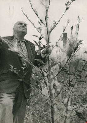
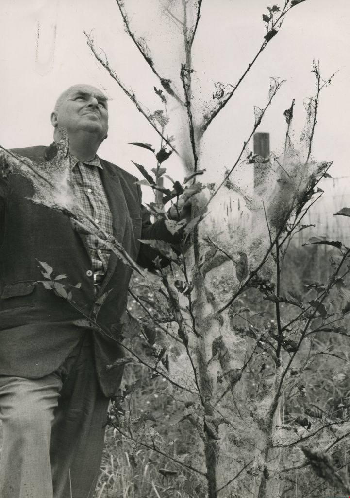
William Hawley surveys tree destruction
https://search.heritageburnaby.ca/link/archivedescription45198
- Repository
- City of Burnaby Archives
- Date
- 1962, published September 8, 1962
- Collection/Fonds
- Columbian Newspaper collection
- Description Level
- Item
- Physical Description
- 1 photograph : b&w ; 20 x 14 cm
- Scope and Content
- Photograph of Columbian farm and garden columnist William Hawley surveying tree destruction caused by tent caterpillars. He was the garden columnist for most of the 1960's, and prior to that he was a salesman and nutritionist for Brackman-Kerr feed store in New Westminster for 40 years. He and his …
- Repository
- City of Burnaby Archives
- Date
- 1962, published September 8, 1962
- Collection/Fonds
- Columbian Newspaper collection
- Physical Description
- 1 photograph : b&w ; 20 x 14 cm
- Description Level
- Item
- Record No.
- 480-094
- Access Restriction
- No restrictions
- Reproduction Restriction
- Reproduce for fair dealing purposes only
- Accession Number
- 2003-02
- Scope and Content
- Photograph of Columbian farm and garden columnist William Hawley surveying tree destruction caused by tent caterpillars. He was the garden columnist for most of the 1960's, and prior to that he was a salesman and nutritionist for Brackman-Kerr feed store in New Westminster for 40 years. He and his wife Doreen were married for 52 years.
- Subjects
- Occupations - Journalists
- Plants - Trees
- Media Type
- Photograph
- Notes
- Title based on contents of photograph
Images
![Survey and Subdivision plans in New Westminster District Group 1 – Burnaby
, [1905-1912] thumbnail](/media/hpo/_Data/_BVM_Cartographic_Material/1977/1977_0093_0021a_001.jpg?width=280)
Survey and Subdivision plans in New Westminster District Group 1 – Burnaby
https://search.heritageburnaby.ca/link/museumdescription6990
- Repository
- Burnaby Village Museum
- Date
- [1905-1912]
- Collection/Fonds
- Burnaby Village Museum Map collection
- Description Level
- File
- Physical Description
- 10 plans : 2 blueprint on paper + 7 black ink on paper + 1 graphite on paper mounted on cardboard 76 x 102 cm
- Scope and Content
- Item consists of a large board of five New Westminster District subdivision plans mounted on one side and five New Westminster District subdivision plans mounted on the other side. Side A: 1. "Survey / of / a Portion / of / Lot 95 Gr.1 / Scale : 1 ch = 1 in". Plan shows Lot 9, Lot 10 and Lot 11 o…
- Repository
- Burnaby Village Museum
- Collection/Fonds
- Burnaby Village Museum Map collection
- Description Level
- File
- Physical Description
- 10 plans : 2 blueprint on paper + 7 black ink on paper + 1 graphite on paper mounted on cardboard 76 x 102 cm
- Material Details
- Scales [between 1:792 and 1:3960]
- Index number on edge of board reads: "21"
- Scope and Content
- Item consists of a large board of five New Westminster District subdivision plans mounted on one side and five New Westminster District subdivision plans mounted on the other side. Side A: 1. "Survey / of / a Portion / of / Lot 95 Gr.1 / Scale : 1 ch = 1 in". Plan shows Lot 9, Lot 10 and Lot 11 of District Lot 95, northeast of Vancouver Road and B.C.E. Tramway. Plan is initialed by: "RB" [sic] (in blue pencil crayon) (Geographic location: Burnaby) 2. Plan of "Lot 12, 13, 2, Gr.1" (handwritten in blue crayon) with Note: "Figures shown in / Red are from Reg. / Plan No 898" and "Scale 4 chains to 1 inch" (written in graphite). Plan identifies the Brunette River running through Lot 12, Lot 13 and Lot 1 and is bordered by North Road to the east and Cariboo Road to the south west. Plan is initialed by: "RB" [sic] (in blue pencil crayon) and stamped: "Albert J. Hill, Civil Engineer / and / Provincial Land Surveyor, / New Westminster, / B.C." (Geographic location: Burnaby) 3. Subdivision plan of a "Portion / of / Lot 29 Gr.1" The plan shows Lots two through fourteen North of Vancouver Road. Name on plan reads: "Reichenbach" and "Scale 2 chs = 1 in" . Plan is initialed by: "RB" [sic] (in blue pencil crayon) nd stamped: "Albert J. Hill, Civil Engineer / and / Provincial Land Surveyor, / New Westminster, / B.C." (Geographic location: Burnaby) 4. Plan of "SUBDvn 10, L88 / "Sc. 1 ch = 1 in / Albert J. Hill / P.L.S.". Plan shows Lot 88 and Lot 25 running along a ravine and Cumberland Street and identifies the "Jensen" house as well as a "stable" and "barn". Plan is initialed by: "RB" [sic] (in blue pencil crayon) and stamped: "Albert J. Hill, Civil Engineer / and / Provincial Land Surveyor, / New Westminster, / B.C." Note handwritten in pencil reads: "Cancelled / See other Side". See also plan 3B. (Geographic location: Burnaby) 5. "Survey / of / Roberts Road / and / Power House Road / Scale 200' = 1" ". Survey for roads identifies North Arm Road, Byrne Road, Woollard, Lot 155A, Lot 160, Lot 159, Lot 96 and Lot 97. Plan is initialed by: "RB" [sic] (in blue pencil crayon) and stamped: "Albert J. Hill, Civil Engineer / and / Provincial Land Surveyor, / New Westminster, / B.C." (Geographic location: Burnaby) Side B: 1. Plan of "Lot 29, G. 1" "McDonald's Lot / Vancouver Road". Plan shows the subdivision of District Lot 29 with the name "S McDonald" marked on one lot next to another identified as "Carter Smith". Lots within survey plan are all north of Vancouver Road and west of Wise Road. Plan is initialed by: "RB" [sic] (in blue pencil crayon) (Geographic location: Burnaby) 2. Plan of "Location / for Burnaby Council / of / the West Boundary of Lots 161 & 175 / Group One" Plan is initialed by: "RB" [sic] (in blue pencil crayon) and stamped: "Albert J. Hill, Civil Engineer / and / Provincial Land Surveyor, / New Westminster, / B.C." (Geographic location: Burnaby) 3. Blueprint plan of "SUBDvn 10, L88 / "Sc. 1 ch = 1 in / Albert J. Hill / P.L.S.". Subdivision plan shows Lot 88 and Lot 25 running along a ravine and Cumberland Street and identifies the "Jensen" house as well as a "stable" and "barn". Plan is initialed by: "RB" [sic] with note "Previous map on / other side hereof" (in blue pencil crayon). See also plan 4A. (Geographic location: Burnaby) 4. Plan titled: "Western Addition / Plan of Subdivision / of / Lots 159_160 / and Part of / Lot 158 / Group One / New Westminster District / Scale : 5 chs = 1 in / to The City of / New Westminster." Plan is initialed by: "RB" [sic] (in blue pencil crayon) (Geographic location: Burnaby) 5. Plan "of Resubdivision/ of Lot 11 / in the Subdivision / of Lots D, C, & G / Lot 96 / Group One / New Westminster District / Scale 2 ch = 1 in" Plan is initialed by: "RB" [sic] (in blue pencil crayon) (Geographic location: Burnaby)
- Creator
- Hill, Albert James
- Accession Code
- HV977.93.21
- Access Restriction
- No restrictions
- Reproduction Restriction
- No known restrictions
- Date
- [1905-1912]
- Media Type
- Cartographic Material
- Scan Resolution
- 300
- Scale
- 72
- Notes
- Title based on contents of file
- Scale is measured in chains and feet. (One chain equals 792 inches)
- The term "Lot" can also refer to a "District Lot”
Images
![Survey and Subdivision plans in New Westminster District Group 1 – Burnaby
, [1905-1912] thumbnail](/media/hpo/_Data/_BVM_Cartographic_Material/1977/1977_0093_0021a_001.jpg)

![Survey and Subdivision plans in New Westminster District Group 2 - Surrey, Delta
, [1898-1910] thumbnail](/media/hpo/_Data/_BVM_Cartographic_Material/1977/1977_0093_0078_001.jpg?width=280)
Survey and Subdivision plans in New Westminster District Group 2 - Surrey, Delta
https://search.heritageburnaby.ca/link/museumdescription7047
- Repository
- Burnaby Village Museum
- Date
- [1898-1910]
- Collection/Fonds
- Burnaby Village Museum Map collection
- Description Level
- File
- Physical Description
- 10 plans : graphite and ink on paper and linen; various sizes mounted on 2 sides of cardboard 76 x 102 cm
- Scope and Content
- File consists of a large board with four plans in New Westminster District mounted on one side and six plans mounted on the other side. Side A: 1. Plan : black ink on paper with colour (no formal title). Plan covers area in New Westminster District, Group 2 situated along the south shore of the …
- Repository
- Burnaby Village Museum
- Collection/Fonds
- Burnaby Village Museum Map collection
- Description Level
- File
- Physical Description
- 10 plans : graphite and ink on paper and linen; various sizes mounted on 2 sides of cardboard 76 x 102 cm
- Material Details
- Scales vary
- Indexed number on tape on edge of board reads "78"
- Scope and Content
- File consists of a large board with four plans in New Westminster District mounted on one side and six plans mounted on the other side. Side A: 1. Plan : black ink on paper with colour (no formal title). Plan covers area in New Westminster District, Group 2 situated along the south shore of the Fraser River identified as "Indian Reserve / Turner 1868" situated in District Lot 1 between District Lot 2 identified as "Mohun's Line" and "Herring's Line" bordered by lots B and A. Includes note "see plan of subdivision of Lots 3 & 4 Gr. 2". (Geographic location: Surrey) 2. Plan : graphite on paper ; Title reads: "B5N R2W, Sec.26_Sec. 28 / Sec. 35_Sec.36". Plan covers a 60 acre parcel in Sec. 35 with Yale wagon road to the south. Scale: 6 chains = 1 inch (Geographic location: Surrey) 3. Plan : black ink on paper ; Title reads: "Survey for Proposed Highway in Indian Reserve Surrey". Plan covers area of land to the northwest of Lot 2 along the shore of the Fraser River and identfies route of proposed highway, proposed tramway as well at the Great Northern Railway and bridge. Scale: 2 chains = 1 inch 4. Plan : black ink on red lined graphing paper ; Title reads: "Sketch Plan Showing Section of Great Northern R. of W. at Point of Crossing of Proposed Ditch". Plan covers area of Lot 2 in New Westminster District, Group 2. (Surrey) Scale: 1 inch = 5 feet. (Geographic location: Surrey) Side B: 1. Plan : black ink on paper ; Title reads: "Plan of Subdivision of a Portion of Section 13, TP2, Surrey Municipality, New Westminster District, B.C.". Plan covers land bordered by Coast Meridian Road (to the east), Bose Road (to the south) and Pike Road (to the west). Surveyed for D.S. Bayners, Nov. 24, 1908. Scale: 5 chains= 1 inch 2. Plan : black ink on linen with colour ; Title reads: "Traverse of the Waterline in front of Lots 3 and 4, Group 2, New Westminster District with G.N. Railway Right of Way". Plan covers area along the southern shore of the Fraser River with a road crossing the Great Northern Railway and leading to a wharf. Scale: 100 feet = 1 inch (Geographic location: Surrey) 3. Plan : black ink on paper ; Title reads: "Survey of the South Boundary of Sec. 12, Township 2, New Westminster District". Plan covers area south of Bose Road and west of Coast Meridean Road and north of McClellen Road. Scale: 400 feet = 1 inch. Sec.12 (Geographic location: Surrey) 4. Plan : graphite on paper ; Title reads: "Plan of Subdivisioin of a part of S.E. 1/4 of Sec. 7, TP 8". Plan covers area of Section 7 in New Westminster District, Group 2, Township 8. Streets are identified running through lot including, Langley Ave., Robinson Ave, Melrose Ave., Hawthorne Ave., Broadway, Bond Ave., Mable Ave., Breene Ave. and McLelland Ave. and Clover Valley Road. Scale: 200 feet = 1 inch. Note in black ink reads: See Bd. 166 for blue print. (Geographic location: Surrey) 5. Plan : graphite on linen ; Title reads: "Sec.20, B5N R2W". Plan covers area north of Yale Road and is subdivided into parts identified as A, B, C, D, E, and unknown. (Geographic location: Surrey) 6. Plan : black ink and graphite on paper ; (no formal title) Plan covers lots surveyed along Ladner Road identified as A, B and Lots 13, 12 and 11. [Geographic location: Delta]
- Accession Code
- HV977.93.78
- Access Restriction
- No restrictions
- Reproduction Restriction
- No known restrictions
- Date
- [1898-1910]
- Media Type
- Cartographic Material
- Scan Resolution
- 600
- Scan Date
- 2023-06-26
- Notes
- Title based on contents of file
- Note re plans 1A & 3A: The sight of Brownsville was also the former site of the Qayqayt First Nation and one of the main summer villages of the Kwantlen and ʷməθkʷəy̓əm (Musqueam) peoples
- Scale is measured in chains and feet. (One chain equals 792 inches)
Zoomable Images
![Survey and Subdivision plans in New Westminster District Group 2 - Surrey, Delta
, [1898-1910] thumbnail](/media/hpo/_Data/_BVM_Cartographic_Material/1977/1977_0093_0078_003_seadragon/1977_0093_0078_003.jpg?w=280)
Survey and Subdivision plans in New Westminster District Group 2 - Surrey, Delta , [1898-1910]
Zoom into Image
Resurvey of the Municipality of Burnaby - Miscellaneous
https://search.heritageburnaby.ca/link/archivedescription743
- Repository
- City of Burnaby Archives
- Date
- 1913-1926
- Collection/Fonds
- City Council and Office of the City Clerk fonds
- Description Level
- File
- Physical Description
- 4 folders textual records and cartographic material
- Scope and Content
- File contains correspondence regarding the re-survey of the Municipality of Burnaby. As well, file includes "Report on the Special Survey of Burnaby up to June 1, 1915" which includes a linen plan of "Complete Special Survey" and "Block Outline Special Survey." Also included are lists of property…
- Repository
- City of Burnaby Archives
- Date
- 1913-1926
- Collection/Fonds
- City Council and Office of the City Clerk fonds
- Physical Description
- 4 folders textual records and cartographic material
- Description Level
- File
- Record No.
- 2476
- Accession Number
- 2001-02
- Scope and Content
- File contains correspondence regarding the re-survey of the Municipality of Burnaby. As well, file includes "Report on the Special Survey of Burnaby up to June 1, 1915" which includes a linen plan of "Complete Special Survey" and "Block Outline Special Survey." Also included are lists of property owners.
- Media Type
- Textual Record
- Cartographic Material
- Notes
- For related records see also 7-2-4-14 and 7-2-4-15, and 7-2-5-1 and 7-2-5-3. Plans/maps are located in file and have not been moved to map case.