Narrow Results By
Subject
- Accidents 2
- Buildings - Commercial - Hotels and Motels 1
- Buildings - Residential - Houses 1
- Construction 1
- Geographic Features - Bays 3
- Geographic Features - Beaches 1
- Geographic Features - Canyons 2
- Geographic Features - Channels 2
- Geographic Features - Inlets 7
- Geographic Features - Natural Waterways 1
- Geographic Features - Rivers 6
- Geographic Features - Trails 1
![Lions Gate Bridge, [1938] thumbnail](/media/hpo/_Data/_Archives_Images/_Unrestricted/371/443-009.jpg?width=280)
Lions Gate Bridge
https://search.heritageburnaby.ca/link/archivedescription38442
- Repository
- City of Burnaby Archives
- Date
- [1938]
- Collection/Fonds
- Burnaby Historical Society fonds
- Description Level
- Item
- Physical Description
- 1 photograph : b&w ; 6.2 x 8.2 cm
- Scope and Content
- Photograph of the Lions Gate Bridge over the Burrard Inlet.
- Repository
- City of Burnaby Archives
- Date
- [1938]
- Collection/Fonds
- Burnaby Historical Society fonds
- Subseries
- Photographs subseries
- Physical Description
- 1 photograph : b&w ; 6.2 x 8.2 cm
- Description Level
- Item
- Record No.
- 443-009
- Access Restriction
- No restrictions
- Reproduction Restriction
- No known restrictions
- Accession Number
- BHS2002-13
- Scope and Content
- Photograph of the Lions Gate Bridge over the Burrard Inlet.
- Media Type
- Photograph
- Notes
- Title based on contents of photograph.
Images
![Lions Gate Bridge, [1938] thumbnail](/media/hpo/_Data/_Archives_Images/_Unrestricted/371/443-009.jpg)
![Lions Gate Bridge from Prospect Point in Stanley Park, [1938 or 1939] thumbnail](/media/hpo/_Data/_BVM_Images/2017/201700280036_001.jpg?width=280)
Lions Gate Bridge from Prospect Point in Stanley Park
https://search.heritageburnaby.ca/link/museumdescription4239
- Repository
- Burnaby Village Museum
- Date
- [1938 or 1939]
- Collection/Fonds
- Burnaby Village Museum Photograph collection
- Description Level
- Item
- Physical Description
- 1 photograph : b&w ; 7.5 x 12 cm
- Scope and Content
- Photograph of the Lions Gate bridge, looking northeast towards the north shore mountains in North Vancouver from Prospect Point in Stanley Park, Vancouver.
- Repository
- Burnaby Village Museum
- Collection/Fonds
- Burnaby Village Museum Photograph collection
- Description Level
- Item
- Physical Description
- 1 photograph : b&w ; 7.5 x 12 cm
- Material Details
- "12" stamped on back.
- Scope and Content
- Photograph of the Lions Gate bridge, looking northeast towards the north shore mountains in North Vancouver from Prospect Point in Stanley Park, Vancouver.
- Subjects
- Structures - Bridges
- Names
- Boal, Glen
- Accession Code
- BV017.28.36
- Access Restriction
- No restrictions
- Reproduction Restriction
- No known restrictions
- Date
- [1938 or 1939]
- Media Type
- Photograph
- Scan Resolution
- 600
- Scan Date
- 06-Mar-2018
- Notes
- Title based on contents of photograph
Images
![Lions Gate Bridge from Prospect Point in Stanley Park, [1938 or 1939] thumbnail](/media/hpo/_Data/_BVM_Images/2017/201700280036_001.jpg)

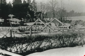
New Brunette River dam construction
https://search.heritageburnaby.ca/link/archivedescription35465
- Repository
- City of Burnaby Archives
- Date
- 1931 (date of original), copied 1986
- Collection/Fonds
- Burnaby Historical Society fonds
- Description Level
- Item
- Physical Description
- 1 photograph : b&w ; 12.7 x 17.8 cm print
- Scope and Content
- Photograph of the construction of new Brunette River dam and Cariboo Road bridge.
- Repository
- City of Burnaby Archives
- Date
- 1931 (date of original), copied 1986
- Collection/Fonds
- Burnaby Historical Society fonds
- Subseries
- Pioneer Tales subseries
- Physical Description
- 1 photograph : b&w ; 12.7 x 17.8 cm print
- Description Level
- Item
- Record No.
- 204-323
- Access Restriction
- No restrictions
- Reproduction Restriction
- No known restrictions
- Accession Number
- BHS1988-03
- Scope and Content
- Photograph of the construction of new Brunette River dam and Cariboo Road bridge.
- Media Type
- Photograph
- Notes
- Title based on contents of photograph
- Historic Neighbourhood
- Burquitlam (Historic Neighbourhood)
- Planning Study Area
- Burnaby Lake Area
Images

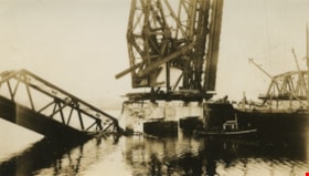
![Old Second Narrows Bridge, [1932] thumbnail](/media/hpo/_Data/_Archives_Images/_Unrestricted/001/011-001.jpg?width=280)
Old Second Narrows Bridge
https://search.heritageburnaby.ca/link/archivedescription34254
- Repository
- City of Burnaby Archives
- Date
- [1932]
- Collection/Fonds
- Burnaby Historical Society fonds
- Description Level
- Item
- Physical Description
- 1 photograph : b&w ; 12.2 x 17.7 cm
- Scope and Content
- Photograph of the first Second Narrows Bridge over the Burrard Inlet in Vancouver, BC. The centre span of the bridge is missing due to a barge accident in 1930 which knocked the span off its supports.
- Repository
- City of Burnaby Archives
- Date
- [1932]
- Collection/Fonds
- Burnaby Historical Society fonds
- Subseries
- Photographs subseries
- Physical Description
- 1 photograph : b&w ; 12.2 x 17.7 cm
- Description Level
- Item
- Record No.
- 011-001
- Access Restriction
- No restrictions
- Reproduction Restriction
- No known restrictions
- Accession Number
- BHS2007-04
- Scope and Content
- Photograph of the first Second Narrows Bridge over the Burrard Inlet in Vancouver, BC. The centre span of the bridge is missing due to a barge accident in 1930 which knocked the span off its supports.
- Subjects
- Structures - Bridges
- Media Type
- Photograph
- Notes
- Continuation of title..."with span out around 1932"
- Annotated at bottom: "Old Second Narrows Bridge with span out around 1932"
Images
![Old Second Narrows Bridge, [1932] thumbnail](/media/hpo/_Data/_Archives_Images/_Unrestricted/001/011-001.jpg)
Original Second Narrows Bridge collapses
https://search.heritageburnaby.ca/link/museumdescription104
- Repository
- Burnaby Village Museum
- Date
- 1930
- Collection/Fonds
- Burnaby Village Museum Photograph collection
- Description Level
- Item
- Physical Description
- 1 photograph : sepia ; 6 x 10.5 cm
- Scope and Content
- Photograph of the aftermath of the Second Narrows Bridge being hit by the"Losmar" pictured on the right. Soon after being built in 1925, the Second Narrows Bridge was hit countless times by ships at the bascule portion installed at the south end of the bridge (unfortunately installed in a shallow w…
- Repository
- Burnaby Village Museum
- Collection/Fonds
- Burnaby Village Museum Photograph collection
- Description Level
- Item
- Physical Description
- 1 photograph : sepia ; 6 x 10.5 cm
- Scope and Content
- Photograph of the aftermath of the Second Narrows Bridge being hit by the"Losmar" pictured on the right. Soon after being built in 1925, the Second Narrows Bridge was hit countless times by ships at the bascule portion installed at the south end of the bridge (unfortunately installed in a shallow water area to avoid building expensive towers and a lift span). Each time it was hit the bridge was out of commission until it was repaired. The Second Narrows Bridge runs over Burrard Inlet and connects Vancouver to North Vancouver.
- Subjects
- Structures - Bridges
- Accidents
- Accession Code
- BV988.31.6
- Access Restriction
- No restrictions
- Date
- 1930
- Media Type
- Photograph
- Related Material
- For another photograph of the collapse of the Second Narrows Bridge, see BV988.31.7
- Scan Resolution
- 600
- Scan Date
- 01-Jun-09
- Scale
- 100
- Notes
- Title based on contents of photograph
- Note in blue pen on verso of photograph reads: "Collapse of original 2nd Narrows Bridge / year?"
Images

![Original Second Narrows Bridge collapses, [between 1925 and 1930] thumbnail](/media/hpo/_Data/_BVM_Images/1985/198800310007.jpg?width=280)
Original Second Narrows Bridge collapses
https://search.heritageburnaby.ca/link/museumdescription105
- Repository
- Burnaby Village Museum
- Date
- [between 1925 and 1930]
- Collection/Fonds
- Burnaby Village Museum Photograph collection
- Description Level
- Item
- Physical Description
- 1 photograph : sepia ; 6 x 10 cm
- Scope and Content
- Photograph of the aftermath of the Second Narrows Bridge being hit by a ship. The span girder is tipped into water on the left side of the photograph and the other girder is broken and in upright position. There is a large ship in the front with letters "CALMAR LINE" written on the side along with …
- Repository
- Burnaby Village Museum
- Collection/Fonds
- Burnaby Village Museum Photograph collection
- Description Level
- Item
- Physical Description
- 1 photograph : sepia ; 6 x 10 cm
- Scope and Content
- Photograph of the aftermath of the Second Narrows Bridge being hit by a ship. The span girder is tipped into water on the left side of the photograph and the other girder is broken and in upright position. There is a large ship in the front with letters "CALMAR LINE" written on the side along with several tug boats. Soon after being built in 1925, the Second Narrows Bridge was hit countless times by ships at the bascule portion installed at the south end of the bridge (unfortunately installed in a shallow water area to avoid building expensive towers and a lift span). Each time it was hit the bridge was out of commission until it was repaired. The Second Narrows Bridge runs over Burrard Inlet and connects Vancouver to North Vancouver.
- Subjects
- Structures - Bridges
- Accidents
- Accession Code
- BV988.31.7
- Access Restriction
- No restrictions
- Date
- [between 1925 and 1930]
- Media Type
- Photograph
- Related Material
- For another photograph of the collapse of the Second Narrows Bridge, see BV988.31.6
- Scan Resolution
- 600
- Scan Date
- 01-Jun-09
- Scale
- 100
- Notes
- Title based on contents of photograph
- Note in blue pen on verso of photograph reads: "Collapse of original 2nd Narrows Bridge / year?"
Images
![Original Second Narrows Bridge collapses, [between 1925 and 1930] thumbnail](/media/hpo/_Data/_BVM_Images/1985/198800310007.jpg)
![Pattullo Bridge and railway bridge, [1938 or 1939] thumbnail](/media/hpo/_Data/_BVM_Images/2017/201700280034_001.jpg?width=280)
Pattullo Bridge and railway bridge
https://search.heritageburnaby.ca/link/museumdescription4237
- Repository
- Burnaby Village Museum
- Date
- [1938 or 1939]
- Collection/Fonds
- Burnaby Village Museum Photograph collection
- Description Level
- Item
- Physical Description
- 1 photograph : b&w ; 7.5 x 12 cm
- Scope and Content
- Photograph of the Pattullo Bridge and railway bridge. Photograph taken looking east from Columbia Street in New Westminster.
- Repository
- Burnaby Village Museum
- Collection/Fonds
- Burnaby Village Museum Photograph collection
- Description Level
- Item
- Physical Description
- 1 photograph : b&w ; 7.5 x 12 cm
- Material Details
- "12" stamped on back.
- Scope and Content
- Photograph of the Pattullo Bridge and railway bridge. Photograph taken looking east from Columbia Street in New Westminster.
- Accession Code
- BV017.28.34
- Access Restriction
- No restrictions
- Reproduction Restriction
- No known restrictions
- Date
- [1938 or 1939]
- Media Type
- Photograph
- Scan Resolution
- 600
- Scan Date
- 06-Mar-2018
- Notes
- Title based on contents of photograph
Images
![Pattullo Bridge and railway bridge, [1938 or 1939] thumbnail](/media/hpo/_Data/_BVM_Images/2017/201700280034_001.jpg)
![Pattullo Bridge and railway bridge, [1938 or 1939] thumbnail](/media/hpo/_Data/_BVM_Images/2017/201700280035_001.jpg?width=280)
Pattullo Bridge and railway bridge
https://search.heritageburnaby.ca/link/museumdescription4238
- Repository
- Burnaby Village Museum
- Date
- [1938 or 1939]
- Collection/Fonds
- Burnaby Village Museum Photograph collection
- Description Level
- Item
- Physical Description
- 1 photograph : b&w ; 7.5 x 12 cm
- Scope and Content
- Photograph of the Pattullo Bridge and railway bridge. Photograph taken looking east from Columbia Street in New Westminster.
- Repository
- Burnaby Village Museum
- Collection/Fonds
- Burnaby Village Museum Photograph collection
- Description Level
- Item
- Physical Description
- 1 photograph : b&w ; 7.5 x 12 cm
- Material Details
- "12" stamped on back.
- Scope and Content
- Photograph of the Pattullo Bridge and railway bridge. Photograph taken looking east from Columbia Street in New Westminster.
- Accession Code
- BV017.28.35
- Access Restriction
- No restrictions
- Reproduction Restriction
- No known restrictions
- Date
- [1938 or 1939]
- Media Type
- Photograph
- Scan Resolution
- 600
- Scan Date
- 06-Mar-2018
- Notes
- Title based on contents of photograph
Images
![Pattullo Bridge and railway bridge, [1938 or 1939] thumbnail](/media/hpo/_Data/_BVM_Images/2017/201700280035_001.jpg)
Picken family home
https://search.heritageburnaby.ca/link/archivedescription35468
- Repository
- City of Burnaby Archives
- Date
- 1931 (date of original), copied 1986
- Collection/Fonds
- Burnaby Historical Society fonds
- Description Level
- Item
- Physical Description
- 1 photograph : b&w ; 12.7 x 17.8 cm print
- Scope and Content
- Photograph of the Picken family home, "Aintree" by the Brunette River, with the mailing address of 2600 Cariboo Road, R.R. 2, New Westminster. The number was later changed to 6825 Cariboo Road, and the mail redirected through Burnaby. The Picken family consisted of Stanley B. Picken (dam keeper …
- Repository
- City of Burnaby Archives
- Date
- 1931 (date of original), copied 1986
- Collection/Fonds
- Burnaby Historical Society fonds
- Subseries
- Pioneer Tales subseries
- Physical Description
- 1 photograph : b&w ; 12.7 x 17.8 cm print
- Description Level
- Item
- Record No.
- 204-326
- Access Restriction
- No restrictions
- Reproduction Restriction
- No known restrictions
- Accession Number
- BHS1988-03
- Scope and Content
- Photograph of the Picken family home, "Aintree" by the Brunette River, with the mailing address of 2600 Cariboo Road, R.R. 2, New Westminster. The number was later changed to 6825 Cariboo Road, and the mail redirected through Burnaby. The Picken family consisted of Stanley B. Picken (dam keeper on the Brunette River), his wife Isabel Picken (formerly Isabel Ponton) and their children.
- Media Type
- Photograph
- Notes
- Title based on contents of photograph
- Geographic Access
- Cariboo Road
- Street Address
- 6825 Cariboo Road
- Historic Neighbourhood
- Burquitlam (Historic Neighbourhood)
- Planning Study Area
- Burnaby Lake Area
Images

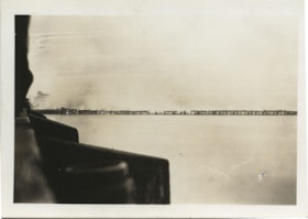
Railway trestle fire
https://search.heritageburnaby.ca/link/museumdescription1423
- Repository
- Burnaby Village Museum
- Date
- August 1938
- Collection/Fonds
- Burnaby Village Museum Photograph collection
- Description Level
- Item
- Physical Description
- 1 photograph : sepia ; 6 x 9 cm
- Scope and Content
- Photograph of a railway trestle fire from a distance. The dark area on left side of the photograph may be the edge of a bridge from where the photograph was taken. Very little details are visible in the smoke. Location is not identified.
- Repository
- Burnaby Village Museum
- Collection/Fonds
- Burnaby Village Museum Photograph collection
- Description Level
- Item
- Physical Description
- 1 photograph : sepia ; 6 x 9 cm
- Material Details
- stamped on verso, t. [sideways] "VANCOUVER/ DRUG CO. LTD./ AUG 3 1938/ Nu- Gloss", l.r. "41 2"
- Scope and Content
- Photograph of a railway trestle fire from a distance. The dark area on left side of the photograph may be the edge of a bridge from where the photograph was taken. Very little details are visible in the smoke. Location is not identified.
- Accession Code
- BV985.5797.1
- Access Restriction
- No restrictions
- Reproduction Restriction
- No known restrictions
- Date
- August 1938
- Media Type
- Photograph
- Scan Resolution
- 600
- Scan Date
- 2024-02-27
- Notes
- Title based on contents of photograph
Images

![Roy Kivisto with Aili and Trudi Rintanen, [between 1937 and 1945] thumbnail](/media/hpo/_Data/_Archives_Images/_Unrestricted/316/337-001.jpg?width=280)
Roy Kivisto with Aili and Trudi Rintanen
https://search.heritageburnaby.ca/link/archivedescription37216
- Repository
- City of Burnaby Archives
- Date
- [between 1937 and 1945]
- Collection/Fonds
- Burnaby Historical Society fonds
- Description Level
- Item
- Physical Description
- 1 photograph : col. ; 10 x 15 cm print
- Scope and Content
- Photograph of Roy Kivisto, Aili Rintanen, and Trudi Rintanen (later Tuomi) sitting on a rock together at the Burrard Inlet squatters' site known as Crabtown. Roy Kivisto was a family friend of the Rintanen's who enjoyed spending the summer on the waterfront. The first version of the Second Narrows …
- Repository
- City of Burnaby Archives
- Date
- [between 1937 and 1945]
- Collection/Fonds
- Burnaby Historical Society fonds
- Subseries
- Trudi Tuomi subseries
- Physical Description
- 1 photograph : col. ; 10 x 15 cm print
- Description Level
- Item
- Record No.
- 337-001
- Access Restriction
- No restrictions
- Reproduction Restriction
- No restrictions
- Accession Number
- BHS1996-20
- Scope and Content
- Photograph of Roy Kivisto, Aili Rintanen, and Trudi Rintanen (later Tuomi) sitting on a rock together at the Burrard Inlet squatters' site known as Crabtown. Roy Kivisto was a family friend of the Rintanen's who enjoyed spending the summer on the waterfront. The first version of the Second Narrows Bridge is visible in the background.
- Media Type
- Photograph
- Notes
- Title based on contents of photograph
- Print is a colour copy of a sepia original
Images
![Roy Kivisto with Aili and Trudi Rintanen, [between 1937 and 1945] thumbnail](/media/hpo/_Data/_Archives_Images/_Unrestricted/316/337-001.jpg)
![Still Creek Bridge, [1930] (date of original), copied 1986 thumbnail](/media/hpo/_Data/_Archives_Images/_Unrestricted/126/160-004.jpg?width=280)
Still Creek Bridge
https://search.heritageburnaby.ca/link/archivedescription34925
- Repository
- City of Burnaby Archives
- Date
- [1930] (date of original), copied 1986
- Collection/Fonds
- Burnaby Historical Society fonds
- Description Level
- Item
- Physical Description
- 1 photograph : b&w ; 12.4 x 8.7 cm print
- Scope and Content
- Photograph of five boys with bullrushes on the Still Creek Bridge, Douglas Road.
- Repository
- City of Burnaby Archives
- Date
- [1930] (date of original), copied 1986
- Collection/Fonds
- Burnaby Historical Society fonds
- Subseries
- Bernard Bellinger subseries
- Physical Description
- 1 photograph : b&w ; 12.4 x 8.7 cm print
- Description Level
- Item
- Record No.
- 160-004
- Access Restriction
- No restrictions
- Reproduction Restriction
- No known restrictions
- Accession Number
- BHS1986-10
- Scope and Content
- Photograph of five boys with bullrushes on the Still Creek Bridge, Douglas Road.
- Subjects
- Structures - Bridges
- Media Type
- Photograph
- Notes
- Title based on contents of photograph
- Geographic Access
- Douglas Road
- Still Creek Avenue
- Historic Neighbourhood
- Burnaby Lake (Historic Neighbourhood)
- Planning Study Area
- Dawson-Delta Area
- Ardingley-Sprott Area
Images
![Still Creek Bridge, [1930] (date of original), copied 1986 thumbnail](/media/hpo/_Data/_Archives_Images/_Unrestricted/126/160-004.jpg)
![Suspension bridge at Hazelton, [1930] thumbnail](/media/hpo/_Data/_Archives_Images/_Unrestricted/001/020-064.jpg?width=280)
Suspension bridge at Hazelton
https://search.heritageburnaby.ca/link/archivedescription34357
- Repository
- City of Burnaby Archives
- Date
- [1930]
- Collection/Fonds
- Burnaby Historical Society fonds
- Description Level
- Item
- Physical Description
- 1 photograph : b&w ; 7.8 x 13 cm
- Scope and Content
- Photograph of a suspension bridge built above a river at a location identified as near Hazelton, BC. A caption included with this picture reads: "Bridge built by Indians at Hazelton." An unidentified man can be seen in the foreground.
- Repository
- City of Burnaby Archives
- Date
- [1930]
- Collection/Fonds
- Burnaby Historical Society fonds
- Subseries
- Peers family subseries
- Physical Description
- 1 photograph : b&w ; 7.8 x 13 cm
- Description Level
- Item
- Record No.
- 020-064
- Access Restriction
- No restrictions
- Reproduction Restriction
- No known restrictions
- Accession Number
- BHS2007-04
- Scope and Content
- Photograph of a suspension bridge built above a river at a location identified as near Hazelton, BC. A caption included with this picture reads: "Bridge built by Indians at Hazelton." An unidentified man can be seen in the foreground.
- Media Type
- Photograph
- Notes
- Title based on contents of photograph
Images
![Suspension bridge at Hazelton, [1930] thumbnail](/media/hpo/_Data/_Archives_Images/_Unrestricted/001/020-064.jpg)
![Suspension bridge at Hazelton, [1930] thumbnail](/media/hpo/_Data/_Archives_Images/_Unrestricted/001/020-065.jpg?width=280)
Suspension bridge at Hazelton
https://search.heritageburnaby.ca/link/archivedescription34358
- Repository
- City of Burnaby Archives
- Date
- [1930]
- Collection/Fonds
- Burnaby Historical Society fonds
- Description Level
- Item
- Physical Description
- 1 photograph : b&w ; 15.8 x 20.4 cm on page 17.4 x 26.4 cm
- Scope and Content
- Photograph of a suspension bridge built above a river at a location identified as near Hazelton, BC. A caption included with this picture reads: "Bridge built by Indians at Hazelton."
- Repository
- City of Burnaby Archives
- Date
- [1930]
- Collection/Fonds
- Burnaby Historical Society fonds
- Subseries
- Peers family subseries
- Physical Description
- 1 photograph : b&w ; 15.8 x 20.4 cm on page 17.4 x 26.4 cm
- Description Level
- Item
- Record No.
- 020-065
- Access Restriction
- No restrictions
- Reproduction Restriction
- No known restrictions
- Accession Number
- BHS2007-04
- Scope and Content
- Photograph of a suspension bridge built above a river at a location identified as near Hazelton, BC. A caption included with this picture reads: "Bridge built by Indians at Hazelton."
- Media Type
- Photograph
- Notes
- Title based on contents of photograph
Images
![Suspension bridge at Hazelton, [1930] thumbnail](/media/hpo/_Data/_Archives_Images/_Unrestricted/001/020-065.jpg)
![Yerba Buena to Oakland, [1939] thumbnail](/media/hpo/_Data/_BVM_Images/1985/1985_6114_0128_001.jpg?width=280)
Yerba Buena to Oakland
https://search.heritageburnaby.ca/link/museumdescription1734
- Repository
- Burnaby Village Museum
- Date
- [1939]
- Collection/Fonds
- Burnaby Village Museum Photograph collection
- Description Level
- Item
- Physical Description
- 1 photograph : b&w ; 5.5 x 8 cm
- Scope and Content
- Photograph of the original Eastern span of San Francisco-Oakland Bay Bridge (built in 1936) taken from Treasure Island. The bridge was constructed in five phases: first the East Span, followed by the tunnel through Yerba Buena Island, and then the West span. This was followed by the I-80 West Appro…
- Repository
- Burnaby Village Museum
- Collection/Fonds
- Burnaby Village Museum Photograph collection
- Description Level
- Item
- Physical Description
- 1 photograph : b&w ; 5.5 x 8 cm
- Scope and Content
- Photograph of the original Eastern span of San Francisco-Oakland Bay Bridge (built in 1936) taken from Treasure Island. The bridge was constructed in five phases: first the East Span, followed by the tunnel through Yerba Buena Island, and then the West span. This was followed by the I-80 West Approach and on- and off-ramps, and finally, the Transbay Terminal in San Francisco.
- Accession Code
- BV985.6114.128
- Access Restriction
- No restrictions
- Reproduction Restriction
- No known restrictions
- Date
- [1939]
- Media Type
- Photograph
- Scan Resolution
- 600
- Scan Date
- 2024-04-02
- Notes
- Title based on note written on verso of photograph
- Handwritten note in black ball-point pen on verso of photograph reads: "Yerba Beuna to Oakland"
- Stamp on verso of photograph reads: "653 F"
- Handwritten note in pencil on verso of photograph crosses out "53" and reads: "41"
Images
![Yerba Buena to Oakland, [1939] thumbnail](/media/hpo/_Data/_BVM_Images/1985/1985_6114_0128_001.jpg)