Narrow Results By

South Burnaby Cenotaph
https://search.heritageburnaby.ca/link/landmark860
- Repository
- Burnaby Heritage Planning
- Description
- The South Burnaby Cenotaph is located in Bonsor Park at the corner of Nelson Avenue and Imperial Street. The cenotaph commemorates those lost in the First World War, Second World War and the Korean War.
- Associated Dates
- 1988
- Other Names
- Bonsor Park Cenotaph
- Street View URL
- Google Maps Street View
- Repository
- Burnaby Heritage Planning
- Other Names
- Bonsor Park Cenotaph
- Geographic Access
- Nelson Avenue
- Associated Dates
- 1988
- Description
- The South Burnaby Cenotaph is located in Bonsor Park at the corner of Nelson Avenue and Imperial Street. The cenotaph commemorates those lost in the First World War, Second World War and the Korean War.
- Historic Neighbourhood
- Central Park (Historic Neighbourhood)
- Planning Study Area
- Marlborough Area
- Community
- Burnaby
- Cadastral Identifier
- P.I.D. No. 027-719-375
- Boundaries
- The property (Bonsor Park) is comprised of a single municipally-owned property located at 6749 Nelson Avenue.
- Area
- 3570.00
- Contributing Resource
- Landscape Feature
- Structure
- Ownership
- Public (local)
- Street Address
- 6749 Nelson Avenue
- Street View URL
- Google Maps Street View
Images


Central Park Entrance
https://search.heritageburnaby.ca/link/archivedescription34860
- Repository
- City of Burnaby Archives
- Date
- March 23, 1985
- Collection/Fonds
- Burnaby Historical Society fonds
- Description Level
- Item
- Physical Description
- 1 photograph : col. ; 8.8 x 11.3 cm
- Scope and Content
- Photograph of the Central Park entrance on Kingsway. A car can be seen exiting the park, and the tracks of the Skytrain Expo line are in the background.
- Repository
- City of Burnaby Archives
- Date
- March 23, 1985
- Collection/Fonds
- Burnaby Historical Society fonds
- Subseries
- Evelyn Salisbury subseries
- Physical Description
- 1 photograph : col. ; 8.8 x 11.3 cm
- Description Level
- Item
- Record No.
- 145-008
- Access Restriction
- No restrictions
- Reproduction Restriction
- Reproduce for fair dealing purposes only
- Accession Number
- BHS1985-15
- Scope and Content
- Photograph of the Central Park entrance on Kingsway. A car can be seen exiting the park, and the tracks of the Skytrain Expo line are in the background.
- Subjects
- Structures - Arches
- Media Type
- Photograph
- Notes
- Title based on contents of photograph
- Geographic Access
- Central Park
- Imperial Street
- Street Address
- 3883 Imperial Street
- Historic Neighbourhood
- Central Park (Historic Neighbourhood)
- Planning Study Area
- Maywood Area
Images


Central Park Entrance
https://search.heritageburnaby.ca/link/archivedescription34861
- Repository
- City of Burnaby Archives
- Date
- March 23, 1985
- Collection/Fonds
- Burnaby Historical Society fonds
- Description Level
- Item
- Physical Description
- 1 photograph : col. ; 8.8 x 11.3 cm
- Scope and Content
- Photograph of the Central Park entrance on Kingsway. The tracks of the Skytrain Expo line can be seen in the background.
- Repository
- City of Burnaby Archives
- Date
- March 23, 1985
- Collection/Fonds
- Burnaby Historical Society fonds
- Subseries
- Evelyn Salisbury subseries
- Physical Description
- 1 photograph : col. ; 8.8 x 11.3 cm
- Description Level
- Item
- Record No.
- 145-009
- Access Restriction
- No restrictions
- Reproduction Restriction
- Reproduce for fair dealing purposes only
- Accession Number
- BHS1985-15
- Scope and Content
- Photograph of the Central Park entrance on Kingsway. The tracks of the Skytrain Expo line can be seen in the background.
- Subjects
- Structures - Arches
- Media Type
- Photograph
- Notes
- Title based on contents of photograph
- Geographic Access
- Central Park
- Imperial Street
- Street Address
- 3883 Imperial Street
- Historic Neighbourhood
- Central Park (Historic Neighbourhood)
- Planning Study Area
- Maywood Area
Images


Interview with Judy Hagen by Eric Damer November 7, 2012 - Track 6
https://search.heritageburnaby.ca/link/oralhistory337
- Repository
- City of Burnaby Archives
- Date Range
- 1944-2012
- Length
- 0:12:18
- Summary
- This portion of the recording pertains to Judith "Judy" (Robins) Hagen's memories of taking dance lessons and being in Girl Guides. She tells a story of seeing the Second Narrows Bridge collapse in 1958.
- Repository
- City of Burnaby Archives
- Summary
- This portion of the recording pertains to Judith "Judy" (Robins) Hagen's memories of taking dance lessons and being in Girl Guides. She tells a story of seeing the Second Narrows Bridge collapse in 1958.
- Date Range
- 1944-2012
- Photo Info
- Judith "Judy" Robins (later Hagen) posing in a dance costume, 1949. Item no. 549-036.
- Length
- 0:12:18
- Interviewer
- Damer, Eric
- Interview Date
- November 7, 2012
- Scope and Content
- Recording is an interview with Judith "Judy" (Robins) Hagen conducted by Burnaby Village Museum employee Eric Damer, November 7, 2012. Major theme discussed: the neighbourhood of Dover Street.
- Biographical Notes
- Judy Robins (later Hagen) was born in 1941 and grew up in South Burnaby. Her paternal grandfather, a master stone mason from Devon, moved to Vancouver in 1912 to find work before bringing over the rest of the family. He bought three lots in Burnaby and in 1918 moved his family to a small house on Dover Street (formerly Paul Street). Judy’s father, Jack, married, bought one of his father’s lots and built a new home for his family. Judy attended school and church nearby, took dance and piano lessons and participated actively in Girl Guides. After high school, she attended the University of British Columbia (UBC) and then Simon Fraser University (SFU), worked for a few years and then married in 1967 before moving to Courtaney, British Columbia.
- Total Tracks
- 7
- Total Length
- 1:09:51
- Interviewee Name
- Hagen, Judith "Judy" Robins
- Interview Location
- Nanaimo Museum on Vancouver Island
- Interviewer Bio
- Eric Damer is a lifelong British Columbian born in Victoria, raised in Kamloops, and currently residing in Burnaby. After studying philosophy at the University of Victoria, he became interested in the educational forces that had shaped his own life. He completed master’s and doctoral degrees in educational studies at the University of British Columbia with a particular interest in the history of adult and higher education in the province. In 2012, Eric worked for the City of Burnaby as a field researcher and writer, conducting interviews for the City Archives and Museum Oral History Program.
- Collection/Fonds
- Community Heritage Commission Special Projects fonds
- Transcript Available
- None
- Media Type
- Sound Recording
Images

Audio Tracks
Track six of recording of interview with Judy Hagen
Track six of recording of interview with Judy Hagen
https://search.heritageburnaby.ca/media/hpo/_Data/_Archives_Oral_Histories/_Unrestricted/MSS171-011/MSS171-011_Track_6.mp3
Jubilee Arch
https://search.heritageburnaby.ca/link/archivedescription34858
- Repository
- City of Burnaby Archives
- Date
- March 7, 1985
- Collection/Fonds
- Burnaby Historical Society fonds
- Description Level
- Item
- Physical Description
- 1 photograph : col. ; 8.8 x 11.4 cm
- Scope and Content
- Photograph of the back of the Central Park Arch at Patterson Avenue and Kingsway.
- Repository
- City of Burnaby Archives
- Date
- March 7, 1985
- Collection/Fonds
- Burnaby Historical Society fonds
- Subseries
- Evelyn Salisbury subseries
- Physical Description
- 1 photograph : col. ; 8.8 x 11.4 cm
- Description Level
- Item
- Record No.
- 145-006
- Access Restriction
- No restrictions
- Reproduction Restriction
- Reproduce for fair dealing purposes only
- Accession Number
- BHS1985-15
- Scope and Content
- Photograph of the back of the Central Park Arch at Patterson Avenue and Kingsway.
- Media Type
- Photograph
- Notes
- Title based on contents of photograph
- Geographic Access
- Central Park
- Imperial Street
- Street Address
- 3883 Imperial Street
- Historic Neighbourhood
- Central Park (Historic Neighbourhood)
- Planning Study Area
- Maywood Area
Images


Jubilee Arch
https://search.heritageburnaby.ca/link/archivedescription34859
- Repository
- City of Burnaby Archives
- Date
- March 7, 1985
- Collection/Fonds
- Burnaby Historical Society fonds
- Description Level
- Item
- Physical Description
- 1 photograph : col. ; 8.8 x 11.3 cm
- Scope and Content
- Photograph of the front of the Central Park Arch at Patterson Avenue and Kingsway.
- Repository
- City of Burnaby Archives
- Date
- March 7, 1985
- Collection/Fonds
- Burnaby Historical Society fonds
- Subseries
- Evelyn Salisbury subseries
- Physical Description
- 1 photograph : col. ; 8.8 x 11.3 cm
- Description Level
- Item
- Record No.
- 145-007
- Access Restriction
- No restrictions
- Reproduction Restriction
- Reproduce for fair dealing purposes only
- Accession Number
- BHS1985-15
- Scope and Content
- Photograph of the front of the Central Park Arch at Patterson Avenue and Kingsway.
- Media Type
- Photograph
- Notes
- Title based on contents of photograph
- Geographic Access
- Central Park
- Imperial Street
- Street Address
- 3883 Imperial Street
- Historic Neighbourhood
- Central Park (Historic Neighbourhood)
- Planning Study Area
- Maywood Area
Images

![Royal Oak Funeral Chapel's iron gate, [1981] thumbnail](/media/hpo/_Data/_Archives_Images/_Unrestricted/205/222-038.jpg?width=280)
Royal Oak Funeral Chapel's iron gate
https://search.heritageburnaby.ca/link/archivedescription36115
- Repository
- City of Burnaby Archives
- Date
- [1981]
- Collection/Fonds
- Burnaby Historical Society fonds
- Description Level
- Item
- Physical Description
- 1 photograph : b&w ; 17.5 x 24 cm
- Scope and Content
- Photograph of the Royal Oak Funeral Chapel's stone wall and iron gate, located at 3412 Kingsway. This building is also known as 'Glenedward' and its address has been renumbered 5152 Kingsway.
- Repository
- City of Burnaby Archives
- Date
- [1981]
- Collection/Fonds
- Burnaby Historical Society fonds
- Subseries
- Columbian Newspaper subseries
- Physical Description
- 1 photograph : b&w ; 17.5 x 24 cm
- Description Level
- Item
- Record No.
- 222-038
- Access Restriction
- No restrictions
- Reproduction Restriction
- Reproduce for fair dealing purposes only
- Accession Number
- BHS1989-19
- Scope and Content
- Photograph of the Royal Oak Funeral Chapel's stone wall and iron gate, located at 3412 Kingsway. This building is also known as 'Glenedward' and its address has been renumbered 5152 Kingsway.
- Subjects
- Structures - Fences
- Names
- Royal Oak Funeral Chapel
- Media Type
- Photograph
- Photographer
- Hodge, Craig
- Notes
- Title based on contents of photograph
- Stamp on verso of photograph reads: "COLUMBIAN PHOTO BY CRAIG HODGE"
- Geographic Access
- Kingsway
- Street Address
- 5152 Kingsway
- Historic Neighbourhood
- Central Park (Historic Neighbourhood)
- Planning Study Area
- Marlborough Area
Images
![Royal Oak Funeral Chapel's iron gate, [1981] thumbnail](/media/hpo/_Data/_Archives_Images/_Unrestricted/205/222-038.jpg)

Pioneer tales of Burnaby
https://search.heritageburnaby.ca/link/museumlibrary5860
- Repository
- Burnaby Village Museum
- Collection
- Digital Reference Collection
- Reference Collection
- Material Type
- Book
- ISBN
- 096928280x
- Call Number
- 971.133 SON COPY 4
- Contributor
- Sone, Michael
- Place of Publication
- Burnaby, B.C.
- Publisher
- Corporation of the District of Burnaby
- Publication Date
- c1987
- Physical Description
- 495 p. : ill. ; 31 cm.
- Inscription
- "TR687 - Bryburgh" / handprinted in pencil on frontend page
- Library Subject (LOC)
- Pioneers--British Columbia--Burnaby
- Frontier and pioneer life
- Biography
- Object History
- Early Burnaby as recalled by the settlers themselves who arrived from every corner of the world between 1888 and 1930, some witnessing incorporation of the district in 1892, all seeking a better life for themselves and especially for their children, all helping transform the wilderness into the modern municipality of today.
- Notes
- "Editor Michael Sone".
- Includes index.
- 4 copies held: copy 4
Images

Digital Books
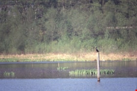
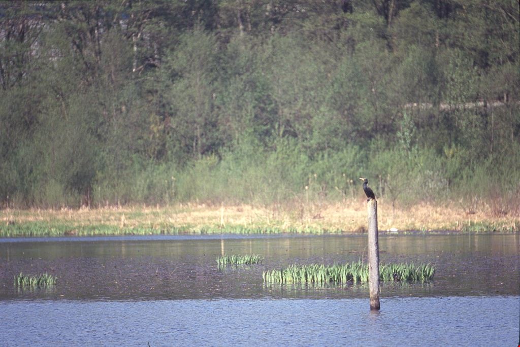
Cormorants
https://search.heritageburnaby.ca/link/archivedescription91686
- Repository
- City of Burnaby Archives
- Date
- 1982-1991
- Collection/Fonds
- Doreen Lawson fonds
- Description Level
- File
- Physical Description
- 4 photographs : col. slides ; 35 mm
- Scope and Content
- File consists of photographs of cormorants. In three of the photographs cormorants are perched on wooded structures on Burnaby Lake; in the forth a cormorant is depicted taking flight from the water. The cormorants are medium-to-large sized birds with dark feathers and long, thin yellow bills.
- Repository
- City of Burnaby Archives
- Date
- 1982-1991
- Collection/Fonds
- Doreen Lawson fonds
- Physical Description
- 4 photographs : col. slides ; 35 mm
- Description Level
- File
- Record No.
- 618-004
- Access Restriction
- No restrictions
- Reproduction Restriction
- No restrictions
- Accession Number
- 2015-15
- Scope and Content
- File consists of photographs of cormorants. In three of the photographs cormorants are perched on wooded structures on Burnaby Lake; in the forth a cormorant is depicted taking flight from the water. The cormorants are medium-to-large sized birds with dark feathers and long, thin yellow bills.
- Media Type
- Photograph
- Photographer
- Lawson, Doreen A.
- Notes
- Transcribed title
- Title transcribed from note on slide sheet photographs were originally housed in
- Historic Neighbourhood
- Burnaby Lake (Historic Neighbourhood)
- Planning Study Area
- Burnaby Lake Area
Images
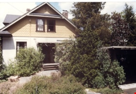
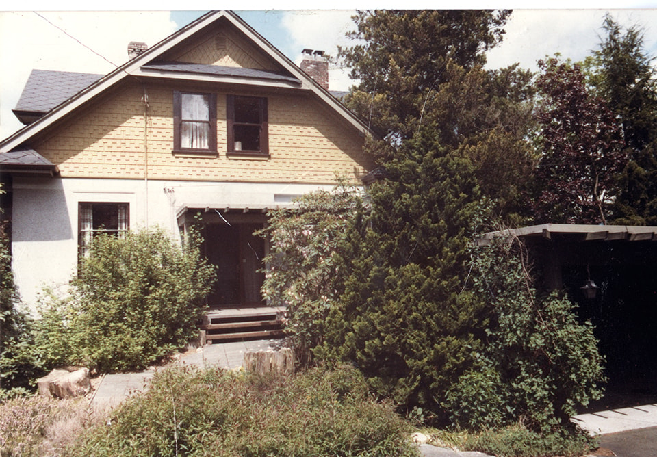
Front of Mawhinney house
https://search.heritageburnaby.ca/link/museumdescription15552
- Repository
- Burnaby Village Museum
- Date
- August 1984
- Collection/Fonds
- Reverend Edward S. Gale fonds
- Description Level
- Item
- Physical Description
- 1 photograph : col. ; 11.5 x 12.5 cm
- Scope and Content
- Photograph of the front of the Mawhinney house located at 7667 Burris Street in Burnaby. The carport structure is visible to the right. Trees and bushes are growing alongside the house and carport.
- Repository
- Burnaby Village Museum
- Collection/Fonds
- Reverend Edward S. Gale fonds
- Description Level
- Item
- Physical Description
- 1 photograph : col. ; 11.5 x 12.5 cm
- Scope and Content
- Photograph of the front of the Mawhinney house located at 7667 Burris Street in Burnaby. The carport structure is visible to the right. Trees and bushes are growing alongside the house and carport.
- Geographic Access
- Burris Street
- Street Address
- 7667 Burris Street
- Accession Code
- BV018.9.20
- Access Restriction
- No restrictions
- Reproduction Restriction
- May be restricted by third party rights
- Date
- August 1984
- Media Type
- Photograph
- Planning Study Area
- Morley-Buckingham Area
- Scan Resolution
- 600
- Scan Date
- April 15, 2021
- Scale
- 100
- Photographer
- Weller, Michael
- Notes
- Title based on contents of photograph
Images
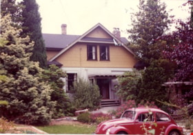
Front of Mawhinney house
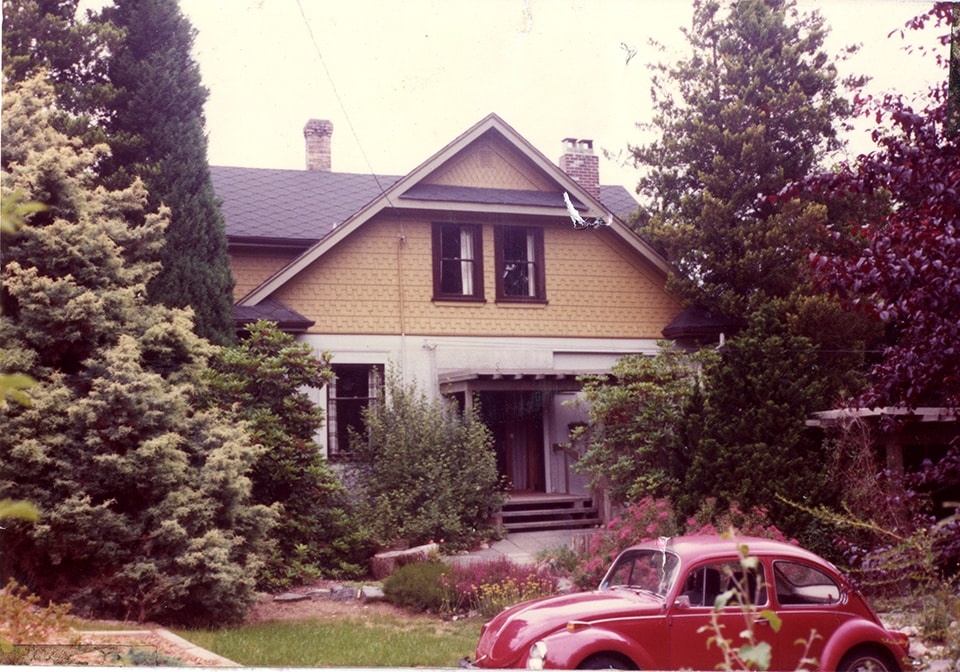
https://search.heritageburnaby.ca/link/museumdescription15553
- Repository
- Burnaby Village Museum
- Date
- August 1984
- Collection/Fonds
- Reverend Edward S. Gale fonds
- Description Level
- Item
- Physical Description
- 1 photograph : col. ; 11.5 x 12.5 cm
- Scope and Content
- Photograph of the front of the Mawhinney house located at 7667 Burris Street in Burnaby. The carport structure is visible to the right. Trees and bushes are growing alongside the house and carport. A red Volkswagon beetle car is parked in front.
- Repository
- Burnaby Village Museum
- Collection/Fonds
- Reverend Edward S. Gale fonds
- Description Level
- Item
- Physical Description
- 1 photograph : col. ; 11.5 x 12.5 cm
- Scope and Content
- Photograph of the front of the Mawhinney house located at 7667 Burris Street in Burnaby. The carport structure is visible to the right. Trees and bushes are growing alongside the house and carport. A red Volkswagon beetle car is parked in front.
- Geographic Access
- Burris Street
- Street Address
- 7667 Burris Street
- Accession Code
- BV018.9.21
- Access Restriction
- No restrictions
- Reproduction Restriction
- May be restricted by third party rights
- Date
- August 1984
- Media Type
- Photograph
- Planning Study Area
- Morley-Buckingham Area
- Scan Resolution
- 600
- Scan Date
- April 15, 2021
- Scale
- 100
- Photographer
- Weller, Michael
- Notes
- Title based on contents of photograph
Images