Narrow Results By
![Brunette Bridge, looking south, [1914] thumbnail](/media/hpo/_Data/_BVM_Images/1971/197200110021.jpg?width=280)
Brunette Bridge, looking south
https://search.heritageburnaby.ca/link/museumdescription3107
- Repository
- Burnaby Village Museum
- Date
- [1914]
- Collection/Fonds
- Burnaby Village Museum Photograph collection
- Description Level
- Item
- Physical Description
- 1 photograph : b&w glass negative ; 16.4 x 21.3 cm
- Scope and Content
- Photograph of North Road and the Brunette Bridge, looking south into New Westminster from Burnaby. By the northern end of the bridge, there is a pit being dug with shovels. A few houses can be seen on the southwest side of the bridge. The house furthest away is identified as the William Holmes hou…
- Repository
- Burnaby Village Museum
- Collection/Fonds
- Burnaby Village Museum Photograph collection
- Description Level
- Item
- Physical Description
- 1 photograph : b&w glass negative ; 16.4 x 21.3 cm
- Scope and Content
- Photograph of North Road and the Brunette Bridge, looking south into New Westminster from Burnaby. By the northern end of the bridge, there is a pit being dug with shovels. A few houses can be seen on the southwest side of the bridge. The house furthest away is identified as the William Holmes house (Burnaby's first settler to pre-empt property in Burnaby). All of the land on the right side of the road was purchased by William H. Holmes in 1860 (District Lot 1, Group 1, New Westminster District). A car is parked on the side of the road south of the bridge. The shorter ash tree south of the bridge is identified as the famous "Holmes Ash Tree" (also known as the "Moody tree").
- Accession Code
- HV972.11.21
- Access Restriction
- No restrictions
- Reproduction Restriction
- No known restrictions
- Date
- [1914]
- Media Type
- Photograph
- Planning Study Area
- Cariboo-Armstrong Area
- Related Material
- See also: William Holmes fonds
- Scan Resolution
- 300
- Scan Date
- 14/8/2006
- Scale
- 100
- Notes
- Title based on contents of photograph
- 1 b&w contact print accompanying negative
- Inscribed on the negative, lower left of the print: "Brunette Bridge / Looking South."
Images
![Brunette Bridge, looking south, [1914] thumbnail](/media/hpo/_Data/_BVM_Images/1971/197200110021.jpg)
![Campbell River truss, [1919] thumbnail](/media/hpo/_Data/_BVM_Images/1974/197500330003bd.jpg?width=280)
Campbell River truss
https://search.heritageburnaby.ca/link/museumdescription3535
- Repository
- Burnaby Village Museum
- Date
- [1919]
- Collection/Fonds
- Burnaby Village Museum Photograph collection
- Description Level
- Item
- Physical Description
- 1 photograph : b&w ; 8 x 13 cm
- Scope and Content
- Photograph of three people standing on a truss in Campbell River. Taken from the west, up river side of the trestle. Tom Irvine was one of the pile drivers who helped to build this bridge.
- Repository
- Burnaby Village Museum
- Collection/Fonds
- Burnaby Village Museum Photograph collection
- Description Level
- Item
- Physical Description
- 1 photograph : b&w ; 8 x 13 cm
- Scope and Content
- Photograph of three people standing on a truss in Campbell River. Taken from the west, up river side of the trestle. Tom Irvine was one of the pile drivers who helped to build this bridge.
- History
- Bloedel Stewart and Welch built a trestle over the Campbell River in Spring 1925. BS&W acquired a timber lease on the south side of the Campbell River in order to access operations at Sayward. This is now the site of the John Hart Hydro Dam.
- Subjects
- Structures - Bridges
- Accession Code
- HV975.33.3bd
- Access Restriction
- No restrictions
- Date
- [1919]
- Media Type
- Photograph
- Scan Resolution
- 600
- Scan Date
- 2/2/2010
- Scale
- 100
- Notes
- Title based on contents of photograph
- Note in black ink on verso of photograph reads: "Campbell River spand [sic]"
- Image from personal photograph album of Tom "Tommy" Irvine (HV975.33.3)
Images
![Campbell River truss, [1919] thumbnail](/media/hpo/_Data/_BVM_Images/1974/197500330003bd.jpg)

Claude and Kitty on a footbridge
https://search.heritageburnaby.ca/link/archivedescription39558
- Repository
- City of Burnaby Archives
- Date
- 1910
- Collection/Fonds
- Peers Family and Hill Family fonds
- Description Level
- Item
- Physical Description
- 1 photograph : b&w ; 7.5 x 10 cm on page 21.5 x 28 cm (pasted in album)
- Scope and Content
- Photograph of Claude Hill with his daughter Kitty standing on a foot bridge over a small creek. In the background directly behind Kitty can be seen the Hill family home known as Broadview which was located on Buckingham Avenue. The Pole Line Road (later renamed Sperling Avenue) can also be seen. …
- Repository
- City of Burnaby Archives
- Date
- 1910
- Collection/Fonds
- Peers Family and Hill Family fonds
- Physical Description
- 1 photograph : b&w ; 7.5 x 10 cm on page 21.5 x 28 cm (pasted in album)
- Description Level
- Item
- Record No.
- 477-877
- Access Restriction
- No restrictions
- Reproduction Restriction
- No known restrictions
- Accession Number
- 2007-12
- Scope and Content
- Photograph of Claude Hill with his daughter Kitty standing on a foot bridge over a small creek. In the background directly behind Kitty can be seen the Hill family home known as Broadview which was located on Buckingham Avenue. The Pole Line Road (later renamed Sperling Avenue) can also be seen. At the far left, top corner of the photograph another house is visible. This was the home of Francis J. Peers, on what is now Rugby Avenue (5289 Rugby). This house was known as Greyfriars. Kitty Hill would later marry Bob Peers, son of Francis.
- Subjects
- Structures - Bridges
- Media Type
- Photograph
- Notes
- Title based on contents of photograph
- Geographic Access
- Buckingham Avenue
- Sperling Avenue
- Street Address
- 5730 Buckingham Avenue
- Historic Neighbourhood
- Burnaby Lake (Historic Neighbourhood)
- Planning Study Area
- Morley-Buckingham Area
Images


Driving over a log bridge
https://search.heritageburnaby.ca/link/archivedescription36026
- Repository
- City of Burnaby Archives
- Date
- 1912
- Collection/Fonds
- Burnaby Historical Society fonds
- Description Level
- Item
- Physical Description
- 1 photograph : sepia ; 7.7 x 10.3 cm
- Scope and Content
- Photograph of Patterson's car driving over a log bridge, believed to be the Cariboo Road Bridge over the Brunette river. A man in a trilby hat is in the driver's side of the car, with his hand on the steering wheel, facing the camera.
- Repository
- City of Burnaby Archives
- Date
- 1912
- Collection/Fonds
- Burnaby Historical Society fonds
- Subseries
- Patterson family subseries
- Physical Description
- 1 photograph : sepia ; 7.7 x 10.3 cm
- Description Level
- Item
- Record No.
- 213-008
- Access Restriction
- No restrictions
- Reproduction Restriction
- No known restrictions
- Accession Number
- BHS1988-13
- Scope and Content
- Photograph of Patterson's car driving over a log bridge, believed to be the Cariboo Road Bridge over the Brunette river. A man in a trilby hat is in the driver's side of the car, with his hand on the steering wheel, facing the camera.
- Media Type
- Photograph
- Notes
- Title based on contents of photograph
- Geographic Access
- Cariboo Road
- Planning Study Area
- Burnaby Lake Area
Images

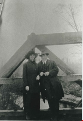
Esther Love and Frank Stanley
https://search.heritageburnaby.ca/link/archivedescription35730
- Repository
- City of Burnaby Archives
- Date
- 1918 (date of original), copied 1986
- Collection/Fonds
- Burnaby Historical Society fonds
- Description Level
- Item
- Physical Description
- 1 photograph : b&w ; 12.7 x 17.8 cm print
- Scope and Content
- Photograph of (left to right) Esther Love and Frank Stanley (her fiance). This photograph was probably taken on the Cariboo Road bridge over the Brunette River during their courtship.
- Repository
- City of Burnaby Archives
- Date
- 1918 (date of original), copied 1986
- Collection/Fonds
- Burnaby Historical Society fonds
- Subseries
- Pioneer Tales subseries
- Physical Description
- 1 photograph : b&w ; 12.7 x 17.8 cm print
- Description Level
- Item
- Record No.
- 204-588
- Access Restriction
- No restrictions
- Reproduction Restriction
- No known restrictions
- Accession Number
- BHS1988-03
- Scope and Content
- Photograph of (left to right) Esther Love and Frank Stanley (her fiance). This photograph was probably taken on the Cariboo Road bridge over the Brunette River during their courtship.
- Subjects
- Structures - Bridges
- Media Type
- Photograph
- Notes
- Title based on contents of photograph
- Geographic Access
- Cariboo Road
- Planning Study Area
- Burnaby Lake Area
Images

![Forth Bridge, [1900-1930] thumbnail](/media/hpo/_Data/_Archives_Images/_Unrestricted/550/550-143.jpg?width=280)
Forth Bridge
https://search.heritageburnaby.ca/link/archivedescription82572
- Repository
- City of Burnaby Archives
- Date
- [1900-1930]
- Collection/Fonds
- Hill family and Vidal family fonds
- Description Level
- Item
- Physical Description
- 1 photograph : col. postcard ; 9 x 14 cm
- Scope and Content
- Photographic postcard shows Forth Bridge in Scotland.
- Repository
- City of Burnaby Archives
- Date
- [1900-1930]
- Collection/Fonds
- Hill family and Vidal family fonds
- Physical Description
- 1 photograph : col. postcard ; 9 x 14 cm
- Description Level
- Item
- Record No.
- 550-143
- Access Restriction
- No restrictions
- Reproduction Restriction
- No known restrictions
- Accession Number
- 2013-03
- Scope and Content
- Photographic postcard shows Forth Bridge in Scotland.
- Subjects
- Structures - Bridges
- Media Type
- Photograph
- Notes
- Title based on contents of photograph
- Postcard verso reads: "The Forth Bridge from South Queens Ferry. One of the greatest engineering glories of the age; was constructed by Sir William Arrol. Is about 1 1/2 miles in length, and its highest point is 450 feet from base. It took seven years to build (1883-1890) and cost 3 1/2 million pounds. It is on the main railway route of the L and N E Railway / New Color-crayon / Process from original drawing by Andrew Allan"
Images
![Forth Bridge, [1900-1930] thumbnail](/media/hpo/_Data/_Archives_Images/_Unrestricted/550/550-143.jpg)

Government Road
https://search.heritageburnaby.ca/link/archivedescription35567
- Repository
- City of Burnaby Archives
- Date
- 1912 (date of original), copied 1986
- Collection/Fonds
- Burnaby Historical Society fonds
- Description Level
- Item
- Physical Description
- 1 photograph : b&w ; 12.7 x 17.8 cm print
- Scope and Content
- Photograph looking east on Government Road from the Haddon family house. One of the men in the photo is Robert Haddon. The other two people are unidentified. Note the loose gravel roadway and the bridge over Eagle Creek.
- Repository
- City of Burnaby Archives
- Date
- 1912 (date of original), copied 1986
- Collection/Fonds
- Burnaby Historical Society fonds
- Subseries
- Pioneer Tales subseries
- Physical Description
- 1 photograph : b&w ; 12.7 x 17.8 cm print
- Description Level
- Item
- Record No.
- 204-425
- Access Restriction
- No restrictions
- Reproduction Restriction
- No known restrictions
- Accession Number
- BHS1988-03
- Scope and Content
- Photograph looking east on Government Road from the Haddon family house. One of the men in the photo is Robert Haddon. The other two people are unidentified. Note the loose gravel roadway and the bridge over Eagle Creek.
- Names
- Haddon, Robert
- Media Type
- Photograph
- Notes
- Title based on contents of photograph
- Geographic Access
- Eagle Creek
- Government Road
- Historic Neighbourhood
- Lozells (Historic Neighbourhood)
- Planning Study Area
- Government Road Area
Images

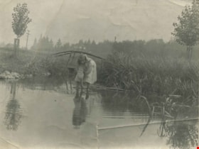
Kitty Hill wading in Deer Lake
https://search.heritageburnaby.ca/link/archivedescription39424
- Repository
- City of Burnaby Archives
- Date
- 1910
- Collection/Fonds
- Peers Family and Hill Family fonds
- Description Level
- Item
- Physical Description
- 1 photograph : b&w ; 7.2 x 10 cm
- Scope and Content
- Photograph of Kitty Hill wading in a small shallow creek. She has her feet submerged, and is dipping her hand in the water while looking up at the photographer. Just behind her is a small log bridge built over the creek, behind which can be seen a street lined with power poles, and a house in the …
- Repository
- City of Burnaby Archives
- Date
- 1910
- Collection/Fonds
- Peers Family and Hill Family fonds
- Physical Description
- 1 photograph : b&w ; 7.2 x 10 cm
- Description Level
- Item
- Record No.
- 477-743
- Access Restriction
- No restrictions
- Reproduction Restriction
- No known restrictions
- Accession Number
- 2007-12
- Scope and Content
- Photograph of Kitty Hill wading in a small shallow creek. She has her feet submerged, and is dipping her hand in the water while looking up at the photographer. Just behind her is a small log bridge built over the creek, behind which can be seen a street lined with power poles, and a house in the far distance, identified as "Broadview". An annotation on the back of the photo reads, "Kitty Hill 1910."
- Media Type
- Photograph
- Notes
- Title based on caption accompanying photograph
- Geographic Access
- Buckingham Avenue
- Deer Lake
- Street Address
- 5730 Buckingham Avenue
- Historic Neighbourhood
- Burnaby Lake (Historic Neighbourhood)
- Planning Study Area
- Morley-Buckingham Area
Images

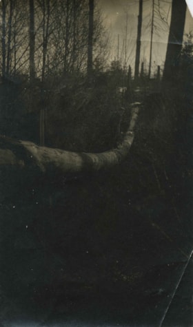
Log bridge
https://search.heritageburnaby.ca/link/archivedescription36025
- Repository
- City of Burnaby Archives
- Date
- 1912
- Collection/Fonds
- Burnaby Historical Society fonds
- Description Level
- Item
- Physical Description
- 1 photograph : b&w ; 14 x 8 cm
- Scope and Content
- Photograph of a log in the creek at Edmonds, acting as a bridge across the creek.
- Repository
- City of Burnaby Archives
- Date
- 1912
- Collection/Fonds
- Burnaby Historical Society fonds
- Subseries
- Patterson family subseries
- Physical Description
- 1 photograph : b&w ; 14 x 8 cm
- Material Details
- Photograph is very dark
- Description Level
- Item
- Record No.
- 213-007
- Access Restriction
- No restrictions
- Reproduction Restriction
- No known restrictions
- Accession Number
- BHS1988-13
- Scope and Content
- Photograph of a log in the creek at Edmonds, acting as a bridge across the creek.
- Subjects
- Structures - Bridges
- Media Type
- Photograph
- Notes
- Title based on contents of photograph
- Handwritten note on verso of photograph reads: " a big log in the creek at Edmonds"
- Quote associated with photograph reads: "Powerhouse Creek at foot of Edmonds"
- Historic Neighbourhood
- Edmonds (Historic Neighbourhood)
- Planning Study Area
- Edmonds Area
Images

![Man on a bridge, [1919] thumbnail](/media/hpo/_Data/_BVM_Images/1974/197500330003bf.jpg?width=280)
Man on a bridge
https://search.heritageburnaby.ca/link/museumdescription3482
- Repository
- Burnaby Village Museum
- Date
- [1919]
- Collection/Fonds
- Burnaby Village Museum Photograph collection
- Description Level
- Item
- Physical Description
- 1 photograph : sepia ; 10 x 6 cm
- Scope and Content
- Photograph of a man walking along a wooden bridge in the interior plateau of British Columbia.
- Repository
- Burnaby Village Museum
- Collection/Fonds
- Burnaby Village Museum Photograph collection
- Description Level
- Item
- Physical Description
- 1 photograph : sepia ; 10 x 6 cm
- Scope and Content
- Photograph of a man walking along a wooden bridge in the interior plateau of British Columbia.
- Subjects
- Structures - Bridges
- Accession Code
- HV975.33.3bf
- Access Restriction
- No restrictions
- Date
- [1919]
- Media Type
- Photograph
- Scan Resolution
- 600
- Scan Date
- 2/2/2010
- Scale
- 100
- Notes
- Title based on contents of photograph
- Image from personal photograph album of Tom "Tommy" Irvine (HV975.33.3)
Images
![Man on a bridge, [1919] thumbnail](/media/hpo/_Data/_BVM_Images/1974/197500330003bf.jpg)

On Curtis Road, North Burnaby
https://search.heritageburnaby.ca/link/archivedescription38854
- Repository
- City of Burnaby Archives
- Date
- 1911
- Collection/Fonds
- Peers Family and Hill Family fonds
- Description Level
- Item
- Physical Description
- 1 photograph : b&w ; 6 x 10 cm on page 14 x 17.5 cm (pasted in album)
- Scope and Content
- Photograph of Claude Hill (right) and E.B. Wentenhall (left) standing on a bridge on Curtis Road in North Burnaby. Both men are holding walking sticks.
- Repository
- City of Burnaby Archives
- Date
- 1911
- Collection/Fonds
- Peers Family and Hill Family fonds
- Physical Description
- 1 photograph : b&w ; 6 x 10 cm on page 14 x 17.5 cm (pasted in album)
- Description Level
- Item
- Record No.
- 477-173
- Access Restriction
- No restrictions
- Reproduction Restriction
- No known restrictions
- Accession Number
- 2007-12
- Scope and Content
- Photograph of Claude Hill (right) and E.B. Wentenhall (left) standing on a bridge on Curtis Road in North Burnaby. Both men are holding walking sticks.
- Subjects
- Structures - Bridges
- Media Type
- Photograph
- Notes
- Title based on caption accompanying photograph
- Geographic Access
- Curtis Street
- Historic Neighbourhood
- Lochdale (Historic Neighbourhood)
- Planning Study Area
- Lochdale Area
Images

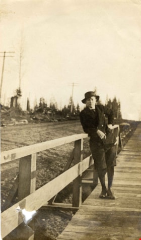
Plank Bridge on Edmonds Street
https://search.heritageburnaby.ca/link/archivedescription38404
- Repository
- City of Burnaby Archives
- Date
- 1911
- Collection/Fonds
- Burnaby Historical Society fonds
- Description Level
- Item
- Physical Description
- 1 photograph : b&w ; 8 x 14 cm
- Scope and Content
- Photograph of a young man standing on a plank bridge on Edmonds Street. The young man appears to be George William (Bill) Ettinger.
- Repository
- City of Burnaby Archives
- Date
- 1911
- Collection/Fonds
- Burnaby Historical Society fonds
- Subseries
- Ettinger family subseries
- Physical Description
- 1 photograph : b&w ; 8 x 14 cm
- Description Level
- Item
- Record No.
- 428-003
- Access Restriction
- No restrictions
- Reproduction Restriction
- No known restrictions
- Accession Number
- BHS2002-03
- Scope and Content
- Photograph of a young man standing on a plank bridge on Edmonds Street. The young man appears to be George William (Bill) Ettinger.
- Subjects
- Structures - Bridges
- Media Type
- Photograph
- Notes
- Title based on contents of photograph
- Geographic Access
- Edmonds Street
- Historic Neighbourhood
- Edmonds (Historic Neighbourhood)
- Planning Study Area
- Edmonds Area
Images

![River bridge, [1919] thumbnail](/media/hpo/_Data/_BVM_Images/1974/197500330003a.jpg?width=280)
River bridge
https://search.heritageburnaby.ca/link/museumdescription3475
- Repository
- Burnaby Village Museum
- Date
- [1919]
- Collection/Fonds
- Burnaby Village Museum Photograph collection
- Description Level
- Item
- Physical Description
- 1 photograph : sepia ; 8 x 13 cm
- Scope and Content
- Photograph of a bridge constructed over an unidentified river. Tom Irvine was one of the pile drivers who helped to build this bridge.
- Repository
- Burnaby Village Museum
- Collection/Fonds
- Burnaby Village Museum Photograph collection
- Description Level
- Item
- Physical Description
- 1 photograph : sepia ; 8 x 13 cm
- Scope and Content
- Photograph of a bridge constructed over an unidentified river. Tom Irvine was one of the pile drivers who helped to build this bridge.
- History
- Bloedel Stewart and Welch built a trestle over the Campbell River in Spring 1925. BS&W acquired a timber lease on the south side of the Campbell River in order to access operations at Sayward. This is now the site of the John Hart Hydro Dam.
- Accession Code
- HV975.33.3a
- Access Restriction
- No restrictions
- Date
- [1919]
- Media Type
- Photograph
- Scan Resolution
- 600
- Scan Date
- 2/2/2010
- Scale
- 100
- Notes
- Title based on contents of photograph
- Image from personal photograph album of Tom "Tommy" Irvine (HV975.33.3)
Images
![River bridge, [1919] thumbnail](/media/hpo/_Data/_BVM_Images/1974/197500330003a.jpg)
![River bridge, [1919] thumbnail](/media/hpo/_Data/_BVM_Images/1974/197500330003i.jpg?width=280)
River bridge
https://search.heritageburnaby.ca/link/museumdescription3492
- Repository
- Burnaby Village Museum
- Date
- [1919]
- Collection/Fonds
- Burnaby Village Museum Photograph collection
- Description Level
- Item
- Physical Description
- 1 photograph : sepia ; 13 x 8 cm
- Scope and Content
- Photograph of a bridge constructed over an unidentified river. Tom Irvine was one of the pile drivers who helped to build this bridge.
- Repository
- Burnaby Village Museum
- Collection/Fonds
- Burnaby Village Museum Photograph collection
- Description Level
- Item
- Physical Description
- 1 photograph : sepia ; 13 x 8 cm
- Scope and Content
- Photograph of a bridge constructed over an unidentified river. Tom Irvine was one of the pile drivers who helped to build this bridge.
- Accession Code
- HV975.33.3i
- Access Restriction
- No restrictions
- Date
- [1919]
- Media Type
- Photograph
- Scan Resolution
- 600
- Scan Date
- 2/2/2010
- Scale
- 100
- Notes
- Title based on contents of photograph
- Image from personal photograph album of Tom "Tommy" Irvine (HV975.33.3)
Images
![River bridge, [1919] thumbnail](/media/hpo/_Data/_BVM_Images/1974/197500330003i.jpg)
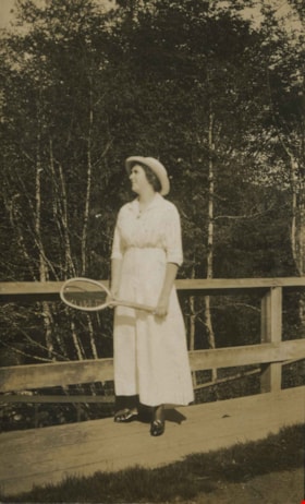
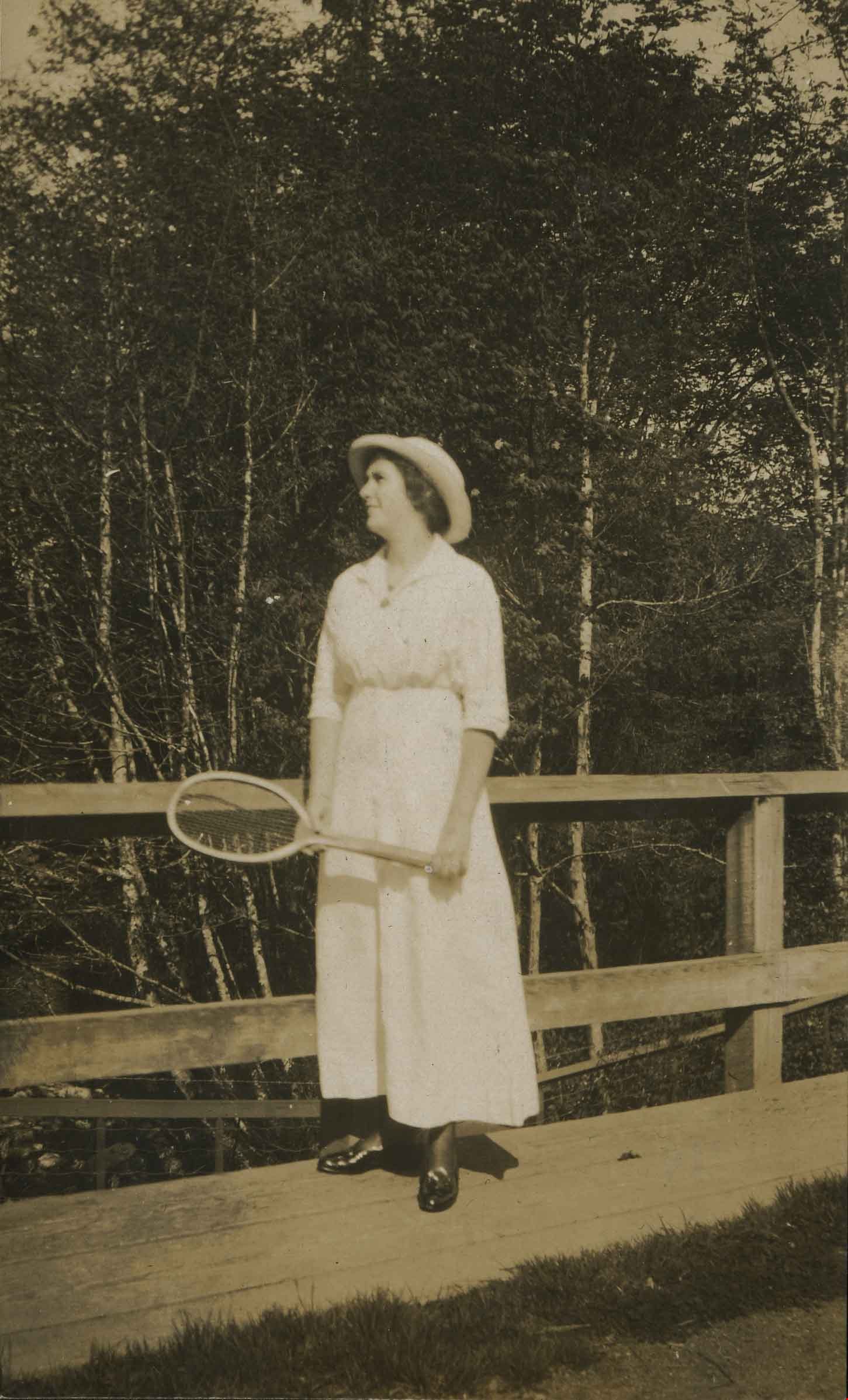
Tennis player
https://search.heritageburnaby.ca/link/archivedescription39229
- Repository
- City of Burnaby Archives
- Date
- 1916
- Collection/Fonds
- Peers Family and Hill Family fonds
- Description Level
- Item
- Physical Description
- 1 photograph : sepia ; 6.2 x 10 cm on page 24.5 x 32.5 cm (pasted in album)
- Scope and Content
- Photograph of a woman holding a tennis racket, standing on a small wooden bridge.
- Repository
- City of Burnaby Archives
- Date
- 1916
- Collection/Fonds
- Peers Family and Hill Family fonds
- Physical Description
- 1 photograph : sepia ; 6.2 x 10 cm on page 24.5 x 32.5 cm (pasted in album)
- Description Level
- Item
- Record No.
- 477-548
- Access Restriction
- No restrictions
- Reproduction Restriction
- No known restrictions
- Accession Number
- 2007-12
- Scope and Content
- Photograph of a woman holding a tennis racket, standing on a small wooden bridge.
- Subjects
- Structures - Bridges
- Sports - Tennis
- Media Type
- Photograph
- Notes
- Title based on contents of photograph
Images
![Tom Irvine, [1919] thumbnail](/media/hpo/_Data/_BVM_Images/1974/197500330003ao.jpg?width=280)
Tom Irvine
https://search.heritageburnaby.ca/link/museumdescription3526
- Repository
- Burnaby Village Museum
- Date
- [1919]
- Collection/Fonds
- Burnaby Village Museum Photograph collection
- Description Level
- Item
- Physical Description
- 1 photograph : b&w ; 13.5 x 8 cm
- Scope and Content
- Photograph of Tom Irvine standing in the centre of a group of men on a suspension bridge. Neither the rest of the men nor the location have been identified. See also photographs at the White Rock Museum and Archives.
- Repository
- Burnaby Village Museum
- Collection/Fonds
- Burnaby Village Museum Photograph collection
- Description Level
- Item
- Physical Description
- 1 photograph : b&w ; 13.5 x 8 cm
- Scope and Content
- Photograph of Tom Irvine standing in the centre of a group of men on a suspension bridge. Neither the rest of the men nor the location have been identified. See also photographs at the White Rock Museum and Archives.
- History
- Likely the Bloedel Stewart and Welch built a trestle over the Campbell River in Spring 1925. BS&W acquired a timber lease on the south side of the Campbell River in order to access operations at Sayward. This is now the site of the John Hart Hydro Dam.
- Subjects
- Structures - Bridges
- Names
- Irvine, Tom
- Accession Code
- HV975.33.3ao
- Access Restriction
- No restrictions
- Date
- [1919]
- Media Type
- Photograph
- Scan Resolution
- 600
- Scan Date
- 2/2/2010
- Scale
- 100
- Notes
- Title based on contents of photograph
- Image from personal photograph album of Tom "Tommy" Irvine (HV975.33.3)
Images
![Tom Irvine, [1919] thumbnail](/media/hpo/_Data/_BVM_Images/1974/197500330003ao.jpg)
![Truss bridge, [1919] thumbnail](/media/hpo/_Data/_BVM_Images/1974/197500330003bc.jpg?width=280)
Truss bridge
https://search.heritageburnaby.ca/link/museumdescription3480
- Repository
- Burnaby Village Museum
- Date
- [1919]
- Collection/Fonds
- Burnaby Village Museum Photograph collection
- Description Level
- Item
- Physical Description
- 1 photograph : sepia ; 5.5 x 8 cm
- Scope and Content
- Photograph of two men and a dog looking at the BS&W trestle constructed at Campbell River. There is a workman's crossing shown below the bridge, allowing workmen to cross from one side of the river to the other. Tom Irvine was involved in the building of the trusses for this bridge.
- Repository
- Burnaby Village Museum
- Collection/Fonds
- Burnaby Village Museum Photograph collection
- Description Level
- Item
- Physical Description
- 1 photograph : sepia ; 5.5 x 8 cm
- Scope and Content
- Photograph of two men and a dog looking at the BS&W trestle constructed at Campbell River. There is a workman's crossing shown below the bridge, allowing workmen to cross from one side of the river to the other. Tom Irvine was involved in the building of the trusses for this bridge.
- History
- Bloedel Stewart and Welch built a trestle over the Campbell River in Spring 1925. BS&W acquired a timber lease on the south side of the Campbell River in order to access operations at Sayward. This is now the site of the John Hart Hydro Dam.
- Subjects
- Structures - Bridges
- Animals - Dogs
- Accession Code
- HV975.33.3bc
- Access Restriction
- No restrictions
- Date
- [1919]
- Media Type
- Photograph
- Scan Resolution
- 600
- Scan Date
- 2/2/2010
- Scale
- 100
- Notes
- Title based on contents of photograph
- Image from personal photograph album of Tom "Tommy" Irvine (HV975.33.3)
Images
![Truss bridge, [1919] thumbnail](/media/hpo/_Data/_BVM_Images/1974/197500330003bc.jpg)
![Truss bridge, [1919] thumbnail](/media/hpo/_Data/_BVM_Images/1974/197500330003p.jpg?width=280)
Truss bridge
https://search.heritageburnaby.ca/link/museumdescription3500
- Repository
- Burnaby Village Museum
- Date
- [1919]
- Collection/Fonds
- Burnaby Village Museum Photograph collection
- Description Level
- Item
- Physical Description
- 1 photograph : b&w ; 8 x 13 cm
- Scope and Content
- Photograph of a truss bridge being constructed over an unidentified waterway. Tom Irvine was one of the pile drivers who helped to build this bridge.
- Repository
- Burnaby Village Museum
- Collection/Fonds
- Burnaby Village Museum Photograph collection
- Description Level
- Item
- Physical Description
- 1 photograph : b&w ; 8 x 13 cm
- Scope and Content
- Photograph of a truss bridge being constructed over an unidentified waterway. Tom Irvine was one of the pile drivers who helped to build this bridge.
- Subjects
- Structures - Bridges
- Accession Code
- HV975.33.3p
- Access Restriction
- No restrictions
- Date
- [1919]
- Media Type
- Photograph
- Scan Resolution
- 600
- Scan Date
- 2/2/2010
- Scale
- 100
- Notes
- Title based on contents of photograph
- Image from personal photograph album of Tom "Tommy" Irvine (HV975.33.3)
Images
![Truss bridge, [1919] thumbnail](/media/hpo/_Data/_BVM_Images/1974/197500330003p.jpg)
![Truss bridge, [1919] thumbnail](/media/hpo/_Data/_BVM_Images/1974/197500330003s.jpg?width=280)
Truss bridge
https://search.heritageburnaby.ca/link/museumdescription3503
- Repository
- Burnaby Village Museum
- Date
- [1919]
- Collection/Fonds
- Burnaby Village Museum Photograph collection
- Description Level
- Item
- Physical Description
- 1 photograph : b&w ; 8 x 13 cm
- Scope and Content
- Photograph of a truss bridge being constructed over an unidentified waterway. Tom Irvine was one of the pile drivers who helped to build this bridge.
- Repository
- Burnaby Village Museum
- Collection/Fonds
- Burnaby Village Museum Photograph collection
- Description Level
- Item
- Physical Description
- 1 photograph : b&w ; 8 x 13 cm
- Scope and Content
- Photograph of a truss bridge being constructed over an unidentified waterway. Tom Irvine was one of the pile drivers who helped to build this bridge.
- Subjects
- Structures - Bridges
- Accession Code
- HV975.33.3s
- Access Restriction
- No restrictions
- Date
- [1919]
- Media Type
- Photograph
- Scan Resolution
- 600
- Scan Date
- 2/2/2010
- Scale
- 100
- Notes
- Title based on contents of photograph
- Image from personal photograph album of Tom "Tommy" Irvine (HV975.33.3)
Images
![Truss bridge, [1919] thumbnail](/media/hpo/_Data/_BVM_Images/1974/197500330003s.jpg)