Narrow Results By
Subject
- Advertising Medium 2
- Advertising Medium - Signs and Signboards 3
- Aerial Photographs 3
- Agricultural Tools and Equipment - Gardening Equipment 1
- Animals - Birds 1
- Animals - Dogs 1
- Animals - Fish 1
- Arts 2
- Buildings - Civic - City Halls 33
- Buildings - Civic - Fire Halls 2
- Buildings - Civic - Libraries 4
- Buildings - Commercial 1

Burnaby Municipal Hall
https://search.heritageburnaby.ca/link/landmark730
- Repository
- Burnaby Heritage Planning
- Geographic Access
- Kingsway
- Associated Dates
- 1899
- Heritage Value
- Although Burnaby was incorporated as a municipality in 1892, its first Municipal Hall was not built until 1899 and located at Kingsway and Edmonds. It was close to the tram line on Kingsway and at the population centre of South Burnaby.
- Historic Neighbourhood
- Edmonds (Historic Neighbourhood)
- Planning Study Area
- Stride Avenue Area
- Street Address
- 7252 Kingsway
- Street View URL
- Google Maps Street View
Images


Burnaby Municipal Hall
https://search.heritageburnaby.ca/link/landmark763
- Repository
- Burnaby Heritage Planning
- Geographic Access
- Kingsway
- Associated Dates
- 1911
- Heritage Value
- In 1911, a brick building was built to replace the smaller wooden structure that had served as Burnaby's Municipal Hall since 1899. This new, larger structure was built to reflect Burnaby's growth into a large suburban municipality and remained in use for over 40 years. The old Municipal Hall became a public hall which was demolished upon the construction of the Edmonds Branch of the Burnaby Public Library in 1962. The second Municipal Hall was renovated in 1956 (when the current City Hall was built at Canada Way), and was used as a Police building. In 1966 after the construction of the new Justice Building, the old 1911 Municipal Hall was left vacant and in 1970 it was demolished. The site was redeveloped as a senior citizens residential centre with Edmonds House built on the old hall location.
- Historic Neighbourhood
- Edmonds (Historic Neighbourhood)
- Planning Study Area
- Stride Avenue Area
- Street Address
- 7282 Kingsway
Images


Byrne Creek Secondary School
https://search.heritageburnaby.ca/link/landmark849
- Repository
- Burnaby Heritage Planning
- Geographic Access
- 18th Street
- Associated Dates
- 2005
- Heritage Value
- Byrne Creek School opened in 2005 and accommodates students from grades 8 through 12. When built, the school was created to house as many as 1200 students, but by 2009, plans have been prepared to increase that capacity to 1500.
- Historic Neighbourhood
- Edmonds (Historic Neighbourhood)
- Planning Study Area
- Stride Avenue Area
- Street Address
- 7777 18th Street
- Street View URL
- Google Maps Street View
Images


East Burnaby Neighbourhood
https://search.heritageburnaby.ca/link/landmark712
- Repository
- Burnaby Heritage Planning
- Associated Dates
- 1925-1954
- Heritage Value
- After a lull in construction during the World War I period, East Burnaby Neighbourhood's growth resumed during the 1920s when many homes and businesses were constructed. The post-World War Two period also saw rapid construction and the creation of new housing developments in response to a population boom. The neighbourhood remained a primarily single-family residential area.
- Historic Neighbourhood
- Edmonds (Historic Neighbourhood)
- Planning Study Area
- Stride Avenue Area
Images


Edmonds Neighbourhood
https://search.heritageburnaby.ca/link/landmark704
- Repository
- Burnaby Heritage Planning
- Associated Dates
- 1925-1954
- Heritage Value
- The historic growth of Edmonds as a neighbourhood was based on its strategic location on the early interurban line between Vancouver and New Westminster. Even by 1980 when a survey of the residential neighbourhoods was conducted, a full 25% of homes in the area predated 1930. The 1950s was a period of strong housing development, with both single-family and multi-family units being constructed. Although Burnaby's City Hall was moved from Kingsway and Edmonds in the early 1950s, Edmonds remained an important centre in the community.
- Historic Neighbourhood
- Edmonds (Historic Neighbourhood)
- Planning Study Area
- Stride Avenue Area
Images


England House
https://search.heritageburnaby.ca/link/landmark501
- Repository
- Burnaby Heritage Planning
- Description
- The Mary England Residence is a one and one-half storey, wood-frame, Period Revival cottage with a steeply pitched, cross-gabled roof. Situated on Griffiths Drive within the Edmonds neighbourhood of Burnaby, the Mary England Residence has an original attached garage.
- Associated Dates
- 1930
- Formal Recognition
- Community Heritage Register
- Other Names
- Mary England Residence
- Street View URL
- Google Maps Street View
- Repository
- Burnaby Heritage Planning
- Other Names
- Mary England Residence
- Geographic Access
- Griffiths Drive
- Associated Dates
- 1930
- Formal Recognition
- Community Heritage Register
- Enactment Type
- Council Resolution
- Enactment Date
- 26/05/2003
- Description
- The Mary England Residence is a one and one-half storey, wood-frame, Period Revival cottage with a steeply pitched, cross-gabled roof. Situated on Griffiths Drive within the Edmonds neighbourhood of Burnaby, the Mary England Residence has an original attached garage.
- Heritage Value
- The Mary England Residence, built in 1930, is valued as a representation of the period revival styles that were popular in the era between the two World Wars. At this time, it was considered the height of fashion for a house to reflect historical styles, even when combined in an eclectic manner, that expressed a domestic ideal of cozy traditionalism. The Mary England Residence is an exuberant example of this trend. Half-timbering, multi-paned and leaded casement windows and a steeply pitched, cross-gabled roof impart a storybook cottage charm. Its first owner, Mary England, was employed for several years as stenographer at the old Burnaby Municipal Hall. An original attached garage is evidence of the growing presence of automobiles in domestic life of the 1930s. Additionally, the Mary England Residence is a testament to the continued suburban growth of the Edmonds neighbourhood. During the Edwardian era, the area experienced a housing boom. Its proximity to New Westminster, coupled with its regional transportation links, made it an attractive area for middle-class residences. Despite the economic recession of the 1930s, the Edmonds area continued to develop with modest but handsome housing.
- Defining Elements
- Key elements that define the heritage character of the Mary England Residence: - location, in the Edmonds neighbourhood of East Burnaby - residential form, scale and massing as expressed by its one and one-half storey height with full basement, rectangular plan and steeply pitched cross-gabled roof - Period Revival elements such as rough-cast stucco, half-timbering, minimal eave overhangs, arched entry with glazed wooden front door, and arched-top feature window - mixture of windows including: double-hung, multi-paned wooden sash windows in double assembly; 6-over-1 double-hung wooden sash windows in multiple assembly; multi-paned casement windows; and straight-leaded feature windows - external parged chimney and two internal chimneys - attached front-gabled garage - associated landscape features including mature deciduous trees and fruit trees
- Historic Neighbourhood
- Edmonds (Historic Neighbourhood)
- Planning Study Area
- Stride Avenue Area
- Function
- Primary Historic--Single Dwelling
- Primary Current--Single Dwelling
- Community
- Edmonds
- Cadastral Identifier
- P.I.D.011-115-424
- Boundaries
- The Mary England Residence is comprised of a single residential lot located at 7276 Griffiths Drive, Burnaby.
- Area
- 1404.26
- Contributing Resource
- Building
- Ownership
- Public (local)
- Documentation
- City of Burnaby Planning and Building Department, Heritage Site Files
- Street Address
- 7276 Griffiths Drive
- Street View URL
- Google Maps Street View
Images


Kingsway
https://search.heritageburnaby.ca/link/landmark775
- Repository
- Burnaby Heritage Planning
- Associated Dates
- 1913
- Heritage Value
- The years 1911-1912 saw great expansion and settlement in Burnaby and large public works projects were undertaken to service the growing community. One project that was determined to be a necessity was the construction of a proper highway between New Westminster and Vancouver. The Province and the Municipality agreed to share the costs of construction (with Burnaby paying 25% and the Province 75%) and so Kingsway was built to improve the current Vancouver Road. The road was named after the famous King's Way in London, England.
- Historic Neighbourhood
- Central Park (Historic Neighbourhood)
- Edmonds (Historic Neighbourhood)
- Planning Study Area
- Maywood Area
- Marlborough Area
- Windsor Area
- Kingsway-Beresford Area
- Stride Avenue Area
- Edmonds Area
Images


Stride Avenue Neighbourhood
https://search.heritageburnaby.ca/link/landmark845
- Repository
- Burnaby Heritage Planning
- Associated Dates
- 1955-2008
- Heritage Value
- The interurban link between New Westminster and Vancouver stimulated the early settlement of Stride Avenue. Infilling of the area took place in the early 1950s and the pace of development had slowed considerably by 1970. Duplexes became a popular feature in the decade between 1970 and 1980 and in the late 1980s, the neighbourhood was incorporated into the Edmonds Town Centre South plan.
- Historic Neighbourhood
- Edmonds (Historic Neighbourhood)
- Planning Study Area
- Stride Avenue Area
Images


Stride Avenue School
https://search.heritageburnaby.ca/link/landmark713
- Repository
- Burnaby Heritage Planning
- Geographic Access
- Stride Avenue
- Associated Dates
- 1929
- Heritage Value
- The Stride Avenue School takes its name from the street which had been named after Eber Stride, Burnaby Councillor from 1894-1913. The school opened in 1929 as a two-classroom building although additions were made in 1949, 1953, 1957, 1964, 1969 and 1973.
- Historic Neighbourhood
- Edmonds (Historic Neighbourhood)
- Planning Study Area
- Stride Avenue Area
- Street Address
- 7014 Stride Avenue
- Street View URL
- Google Maps Street View
Images


Thomas & Jane Sincock House
https://search.heritageburnaby.ca/link/landmark646
- Repository
- Burnaby Heritage Planning
- Description
- Residential building.
- Associated Dates
- 1912
- Street View URL
- Google Maps Street View
- Repository
- Burnaby Heritage Planning
- Geographic Access
- 11th Avenue
- Associated Dates
- 1912
- Description
- Residential building.
- Heritage Value
- This small Edwardian-era bungalow home was built and owned by Burnaby resident Jane Sincock (1848-1940) and her husband Thomas Sincock (1844-1916) as an investment rental property. By 1916, the couple was living in New Westminster, on Bole Street, where Jane, who was born in Cornwall, remained until her death. This substantial bungalow is distinguished by its bellcast hipped roof and dormers, an octagonal corner bay, and a small front verandah supported by square tapered columns. The house retains its original lapped wooden siding though the windows have been replaced.
- Locality
- Edmonds
- Historic Neighbourhood
- Edmonds (Historic Neighbourhood)
- Planning Study Area
- Stride Avenue Area
- Area
- 807.78
- Contributing Resource
- Building
- Ownership
- Private
- Street Address
- 7349 11th Avenue
- Street View URL
- Google Maps Street View
Images

![Gilley Brothers Logging team, [1895]. . thumbnail](/media/hpo/_Data/_Archives_Images/_Unrestricted/371/461-003.jpg?width=280)
Vancouver Road (Kingsway)
https://search.heritageburnaby.ca/link/landmark729
- Repository
- Burnaby Heritage Planning
- Associated Dates
- 1860
- Heritage Value
- The street we know as Kingsway is one of the legacies of the Royal Engineers' military defences for New Westminster. The fear of an American attack prompted the construction of the False Creek trail - later known as Vancouver Road and now Kingsway - in 1860 to connect the capital city to the ice-free salt water harbour at English Bay.
- Historic Neighbourhood
- Central Park (Historic Neighbourhood)
- Edmonds (Historic Neighbourhood)
- Planning Study Area
- Maywood Area
- Marlborough Area
- Windsor Area
- Kingsway-Beresford Area
- Stride Avenue Area
- Edmonds Area
Images
![Gilley Brothers Logging team, [1895]. . thumbnail](/media/hpo/_Data/_Archives_Images/_Unrestricted/371/461-003.jpg)
![10th Avenue connector construction, [2002] thumbnail](/media/hpo/_Data/_Archives_Images/_Unrestricted/535/535-1984.jpg?width=280)
10th Avenue connector construction
https://search.heritageburnaby.ca/link/archivedescription96301
- Repository
- City of Burnaby Archives
- Date
- [2002]
- Collection/Fonds
- Burnaby NewsLeader photograph collection
- Description Level
- Item
- Physical Description
- 1 photograph (tiff) : col.
- Scope and Content
- Photograph of the view of the new 10th Avenue connector from Gord Thorneycroft's garage. Thorneycroft holds a mug and is silhouetted by the light coming from outside, where the Bombardier SkyTrain plant is visible in the distance.
- Repository
- City of Burnaby Archives
- Date
- [2002]
- Collection/Fonds
- Burnaby NewsLeader photograph collection
- Physical Description
- 1 photograph (tiff) : col.
- Description Level
- Item
- Record No.
- 535-1984
- Access Restriction
- No restrictions
- Reproduction Restriction
- No restrictions
- Accession Number
- 2018-12
- Scope and Content
- Photograph of the view of the new 10th Avenue connector from Gord Thorneycroft's garage. Thorneycroft holds a mug and is silhouetted by the light coming from outside, where the Bombardier SkyTrain plant is visible in the distance.
- Media Type
- Photograph
- Photographer
- Bartel, Mario
- Notes
- Title based on caption
- Collected by editorial for use in a February 2002 issue of the Burnaby NewsLeader
- Caption from metadata: "Gord Thorneycroft says he used to be able to enjoy his morning coffee looking out onto a quiet, tree-lined lane while working in his garage behind his home on 9th Ave. But workers building the new 10th Ave. connector tore out the trees last September, the City of Burnaby isn't making any promises to erect noise barriers, and his lane has become a thoroughfare to the Bombardier Skytrain plant."
- Geographic Access
- 10th Avenue
- Historic Neighbourhood
- Edmonds (Historic Neighbourhood)
- Planning Study Area
- Stride Avenue Area
Images
![10th Avenue connector construction, [2002] thumbnail](/media/hpo/_Data/_Archives_Images/_Unrestricted/535/535-1984.jpg)
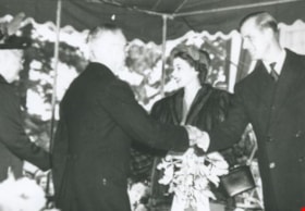
Alice and George Grant meet Princess Elizabeth and the Duke of Edinburgh
https://search.heritageburnaby.ca/link/archivedescription36881
- Repository
- City of Burnaby Archives
- Date
- 1951
- Collection/Fonds
- Burnaby Historical Society fonds
- Description Level
- Item
- Physical Description
- 1 photograph : b&w ; 8.8 x 12.6 cm print
- Scope and Content
- Photograph of Alice and George Grant meeting Princess Elizabeth and the Duke of Edinburgh at Burnaby Municipal Hall.
- Repository
- City of Burnaby Archives
- Date
- 1951
- Collection/Fonds
- Burnaby Historical Society fonds
- Subseries
- Burnaby Centennial Anthology subseries
- Physical Description
- 1 photograph : b&w ; 8.8 x 12.6 cm print
- Description Level
- Item
- Record No.
- 315-339
- Access Restriction
- No restrictions
- Reproduction Restriction
- Reproduce for fair dealing purposes only
- Accession Number
- BHS1994-04
- Scope and Content
- Photograph of Alice and George Grant meeting Princess Elizabeth and the Duke of Edinburgh at Burnaby Municipal Hall.
- Subjects
- Events - Royal Visits
- Names
- Elizabeth II Queen of Great Britain, 1926-2022
- Grant, Alice Taylor
- Grant, George Alford
- Philip, Prince, consort of Elizabeth II, Queen of Great Britain, 1921-
- Media Type
- Photograph
- Notes
- Title based on contents of photograph
- Geographic Access
- Kingsway
- Edmonds Street
- Historic Neighbourhood
- Edmonds (Historic Neighbourhood)
- Planning Study Area
- Stride Avenue Area
Images

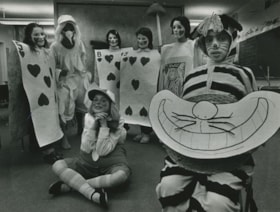
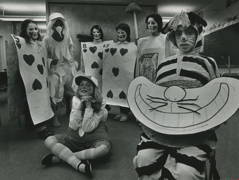
Alice in Wonderland Production - Stride Community School
https://search.heritageburnaby.ca/link/archivedescription59013
- Repository
- City of Burnaby Archives
- Date
- 1983
- Collection/Fonds
- Columbian Newspaper collection
- Description Level
- Item
- Physical Description
- 1 photograph : b&w ; 20.5 x 25.5 cm
- Scope and Content
- Photograph of students dressed in costume for a production of Alice in Wonderland at the Stride Community School.
- Repository
- City of Burnaby Archives
- Date
- 1983
- Collection/Fonds
- Columbian Newspaper collection
- Physical Description
- 1 photograph : b&w ; 20.5 x 25.5 cm
- Description Level
- Item
- Record No.
- 480-1422
- Access Restriction
- No restrictions
- Reproduction Restriction
- No restrictions
- Accession Number
- 2009-01
- Scope and Content
- Photograph of students dressed in costume for a production of Alice in Wonderland at the Stride Community School.
- Subjects
- Persons - Children
- Clothing - Costumes
- Names
- Stride Avenue School
- Media Type
- Photograph
- Photographer
- Battistoni, Peter
- Notes
- Title based on contents of photograph
- Note on recto reads: "Sherri Smart - Card / Isaac Melles - Dodo / Kristie Lamond - Tewedle Dum / Cheralee Hahn Michelle Lapre Jennifer Fox - Cards / Kulvinder Rai - Cheshire Cat"
- Photographer's stamp on verso
- Note on verso reads: "page A-8 / Burnaby / Today / PMT 100% / B-4 Saturday family page / reduce 80% / PMT twice / students stage Alice"
- Newspaper clipping attached to verso reads: "STUDENTS STAGE 'ALICE' ... Audiences attending the 'Alice in Wonderland' production staged this week by Stride Community School in Burnaby were delighted with the colorful portrayal of the familiar Lewis Carroll characters. Above, waiting their turn to go on stage are, from left at rear, Sherri Smart, Isaac Melles, Cheralee Hahn, Michelle Lapre and Jennifer Fox, and in foreground, Kristie Lamond Tweedle Dum and Kulvinder Rai (as the Cheshire cat)."
- Street Address
- 7014 Stride Avenue
- Historic Neighbourhood
- Edmonds (Historic Neighbourhood)
- Planning Study Area
- Stride Avenue Area
Images
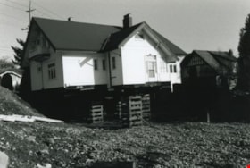
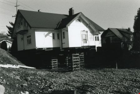
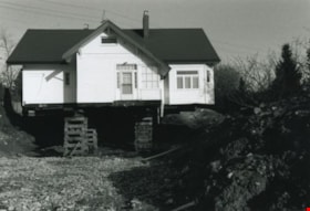
Back and side of the Britton house
https://search.heritageburnaby.ca/link/archivedescription36581
- Repository
- City of Burnaby Archives
- Date
- November 1992
- Collection/Fonds
- Burnaby Historical Society fonds
- Description Level
- Item
- Physical Description
- 1 photograph : b&w ; 10 x 15 cm print
- Scope and Content
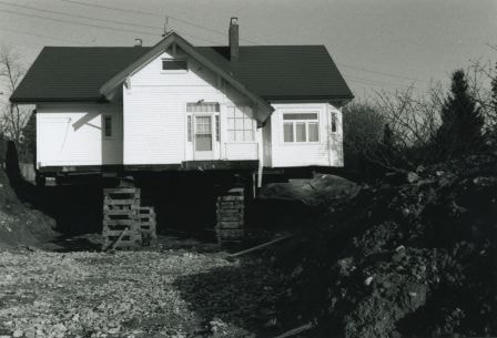
- Photograph of back and side of the Britton house taken from ground level during the Britton house moving project, while the house was up on stilts.
- Repository
- City of Burnaby Archives
- Date
- November 1992
- Collection/Fonds
- Burnaby Historical Society fonds
- Subseries
- Britton family subseries
- Physical Description
- 1 photograph : b&w ; 10 x 15 cm print
- Description Level
- Item
- Record No.
- 303-003
- Access Restriction
- No restrictions
- Reproduction Restriction
- Reproduce for fair dealing purposes only
- Accession Number
- BHS1992-44
- Scope and Content
- Photograph of back and side of the Britton house taken from ground level during the Britton house moving project, while the house was up on stilts.
- Subjects
- Buildings - Residential - Houses
- Media Type
- Photograph
- Notes
- Title based on contents of photograph
- 1 b&w negative accompanying
- Geographic Access
- Kingsway
- Street Address
- 7505 Kingsway
- Historic Neighbourhood
- Edmonds (Historic Neighbourhood)
- Planning Study Area
- Stride Avenue Area
Images
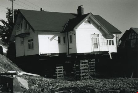
Back and side of the Britton house
https://search.heritageburnaby.ca/link/archivedescription36589
- Repository
- City of Burnaby Archives
- Date
- November 1992
- Collection/Fonds
- Burnaby Historical Society fonds
- Description Level
- Item
- Physical Description
- 1 photograph : b&w ; 10 x 15 cm print
- Scope and Content
- Photograph of back and side of the Britton house taken from ground level during the Britton house moving project, while the house was up on stilts.
- Repository
- City of Burnaby Archives
- Date
- November 1992
- Collection/Fonds
- Burnaby Historical Society fonds
- Subseries
- Britton family subseries
- Physical Description
- 1 photograph : b&w ; 10 x 15 cm print
- Description Level
- Item
- Record No.
- 303-011
- Access Restriction
- No restrictions
- Reproduction Restriction
- Reproduce for fair dealing purposes only
- Accession Number
- BHS1992-44
- Scope and Content
- Photograph of back and side of the Britton house taken from ground level during the Britton house moving project, while the house was up on stilts.
- Subjects
- Buildings - Residential - Houses
- Media Type
- Photograph
- Notes
- Title based on contents of photograph
- 1 b&w negative accompanying
- Geographic Access
- Kingsway
- Street Address
- 7505 Kingsway
- Historic Neighbourhood
- Edmonds (Historic Neighbourhood)
- Planning Study Area
- Stride Avenue Area
Images
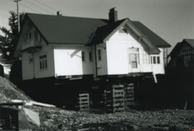
Back of the Britton house
https://search.heritageburnaby.ca/link/archivedescription36585
- Repository
- City of Burnaby Archives
- Date
- November 1992
- Collection/Fonds
- Burnaby Historical Society fonds
- Description Level
- Item
- Physical Description
- 1 photograph : b&w ; 10 x 15 cm print
- Scope and Content
- Photograph of the back of the Britton house up on stilts and its surrounding yard during the Britton house moving project.
- Repository
- City of Burnaby Archives
- Date
- November 1992
- Collection/Fonds
- Burnaby Historical Society fonds
- Subseries
- Britton family subseries
- Physical Description
- 1 photograph : b&w ; 10 x 15 cm print
- Description Level
- Item
- Record No.
- 303-007
- Access Restriction
- No restrictions
- Reproduction Restriction
- Reproduce for fair dealing purposes only
- Accession Number
- BHS1992-44
- Scope and Content
- Photograph of the back of the Britton house up on stilts and its surrounding yard during the Britton house moving project.
- Subjects
- Buildings - Residential - Houses
- Media Type
- Photograph
- Notes
- Title based on contents of photograph
- 1 b&w negative accompanying
- Geographic Access
- Kingsway
- Street Address
- 7505 Kingsway
- Historic Neighbourhood
- Edmonds (Historic Neighbourhood)
- Planning Study Area
- Stride Avenue Area
Images
Banks family home
https://search.heritageburnaby.ca/link/archivedescription37498
- Repository
- City of Burnaby Archives
- Date
- 1933 (date of original), copied 1991
- Collection/Fonds
- Burnaby Historical Society fonds
- Description Level
- Item
- Physical Description
- 1 photograph : b&w ; 2.7 x 4.0 cm print on contact sheet 20.2 x 25.3 cm
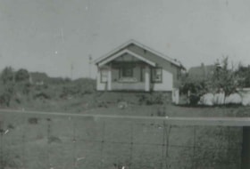
- Scope and Content
- Photograph of the Banks family home at the back of the Burnaby Garage at 1812 Britton Street and Kingsway (later renumbered 7383 Britton Street).
- Repository
- City of Burnaby Archives
- Date
- 1933 (date of original), copied 1991
- Collection/Fonds
- Burnaby Historical Society fonds
- Subseries
- Burnaby Image Bank subseries
- Physical Description
- 1 photograph : b&w ; 2.7 x 4.0 cm print on contact sheet 20.2 x 25.3 cm
- Description Level
- Item
- Record No.
- 370-086
- Access Restriction
- No restrictions
- Reproduction Restriction
- No known restrictions
- Accession Number
- BHS1999-03
- Scope and Content
- Photograph of the Banks family home at the back of the Burnaby Garage at 1812 Britton Street and Kingsway (later renumbered 7383 Britton Street).
- Subjects
- Buildings - Residential - Houses
- Names
- Burnaby Garage
- Media Type
- Photograph
- Notes
- Title based on contents of photograph
- 1 b&w copy negative accompanying
- Geographic Access
- Britton Street
- Street Address
- 7383 Britton Street
- Historic Neighbourhood
- Edmonds (Historic Neighbourhood)
- Planning Study Area
- Stride Avenue Area
Images
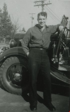
Basil Pontifex at No. 2 Firehall
https://search.heritageburnaby.ca/link/archivedescription37904
- Repository
- City of Burnaby Archives
- Date
- 1947 (date of original), copied 1991
- Collection/Fonds
- Burnaby Historical Society fonds
- Description Level
- Item
- Physical Description
- 1 photograph : b&w ; 3.7 x 2.3 cm print on contact sheet 20.2 x 26.3 cm
- Scope and Content
- Photograph of Basil Pontifex leaning on the front of a truck at the No. 2 Firehall at Kingsway and Hall Avenue. Basil was a Burnaby firefighter.
- Repository
- City of Burnaby Archives
- Date
- 1947 (date of original), copied 1991
- Collection/Fonds
- Burnaby Historical Society fonds
- Subseries
- Burnaby Image Bank subseries
- Physical Description
- 1 photograph : b&w ; 3.7 x 2.3 cm print on contact sheet 20.2 x 26.3 cm
- Description Level
- Item
- Record No.
- 370-492
- Access Restriction
- No restrictions
- Reproduction Restriction
- No known restrictions
- Accession Number
- BHS1999-03
- Scope and Content
- Photograph of Basil Pontifex leaning on the front of a truck at the No. 2 Firehall at Kingsway and Hall Avenue. Basil was a Burnaby firefighter.
- Names
- Pontifex, Basil
- Media Type
- Photograph
- Notes
- Title based on contents of photograph
- 1 b&w copy negative accompanying
- Negative has a pink cast
- Geographic Access
- Kingsway
- Hall Avenue
- Historic Neighbourhood
- Edmonds (Historic Neighbourhood)
- Planning Study Area
- Stride Avenue Area
Images

BC Hydro Railway Crossing
https://search.heritageburnaby.ca/link/archivedescription79487
- Repository
- City of Burnaby Archives
- Date
- September 22, 1976
- Collection/Fonds
- Burnaby Public Library Contemporary Visual Archive Project
- Description Level
- Item
- Physical Description
- 1 photograph : b&w ; 11 x 16 cm mounted on cardboard
- Scope and Content
- Photograph shows BC Hydro railroad tracks and crossing near Beresford Street and Griffiths Avenue.
- Repository
- City of Burnaby Archives
- Date
- September 22, 1976
- Collection/Fonds
- Burnaby Public Library Contemporary Visual Archive Project
- Physical Description
- 1 photograph : b&w ; 11 x 16 cm mounted on cardboard
- Description Level
- Item
- Record No.
- 556-319
- Access Restriction
- No restrictions
- Reproduction Restriction
- Reproduce for fair dealing purposes only
- Accession Number
- 2013-13
- Scope and Content
- Photograph shows BC Hydro railroad tracks and crossing near Beresford Street and Griffiths Avenue.
- Media Type
- Photograph
- Photographer
- Ross, Martha
- Notes
- Scope note taken directly from BPL photograph description.
- 1 b&w copy negative : 10 x 12.5 cm accompanying
- Historic Neighbourhood
- Edmonds (Historic Neighbourhood)
- Planning Study Area
- Stride Avenue Area
Images
