Narrow Results By
Subject
- Advertising Medium - Signs and Signboards 6
- Buildings - Commercial - Grocery Stores 2
- Buildings - Residential - Houses 1
- Buildings - Schools 2
- Celebrations - Centennials 11
- Geographic Features - Parks 1
- Natural Phenomena - Snow 1
- Occupations - Lumberjacks 1
- Officials - Mayors and Reeves 1
- Pandemics - COVID-19 11
- Personal Symbols - Trophies 1
- Recreational Activities - Golf 14

Municipality of Burnaby - Volume XV, Volume XVI, Volume XVII, Volume XVIII
https://search.heritageburnaby.ca/link/museumdescription8685
- Repository
- Burnaby Village Museum
- Date
- May 1927
- Collection/Fonds
- Burnaby Village Museum Map collection
- Description Level
- File
- Physical Description
- 4 plans on 4 sheets : col. lithographic prints ; 63.5 x 53.5 cm folded to 53 x 31.5 cm
- Scope and Content
- File consists of four pages of plans removed from a bound book containing a series of fire insurance plans of the Municipality of Burnaby. Plan "1531" is part of "GREATER VANCOUVER B.C. / VOLUME XV / Municipality of Burnaby / May 1927" and covers District Lots: 116 and 117. Key Plan "C" is part of …
- Repository
- Burnaby Village Museum
- Collection/Fonds
- Burnaby Village Museum Map collection
- Description Level
- File
- Physical Description
- 4 plans on 4 sheets : col. lithographic prints ; 63.5 x 53.5 cm folded to 53 x 31.5 cm
- Material Details
- Scale [1:600] and [1:1200]
- Scope and Content
- File consists of four pages of plans removed from a bound book containing a series of fire insurance plans of the Municipality of Burnaby. Plan "1531" is part of "GREATER VANCOUVER B.C. / VOLUME XV / Municipality of Burnaby / May 1927" and covers District Lots: 116 and 117. Key Plan "C" is part of "GREATER VANCOUVER B.C. / VOLUME XVI / Municipality of Burnaby / May 1927" and covers plans 1623 to 1651 and District Lots: 1 and 2; 4; 6; 8; 10 to 14; 25; 27; 40; 56 to 58; 88 and 89. Plan "1738" is part of "GREATER VANCOUVER B.C. / VOLUME XVII / Municipality of Burnaby / May 1927" and covers District Lots: 34 and 35. Key plan "G" is part of "GREATER VANCOUVER B.C. / VOLUME XVIII / Municipality of Burnaby / May 1927" and covers plans: 1801 to 1813; 1823; 1824; 1833 to 1838; 1841 to 1853 and District Lots: 32; 93; 94; 97 to 99; 149; 150; 152; 155 to 159; 161 to 164.
- Responsibility
- British Columbia Underwriters' Association
- Accession Code
- HV972.111.7
- Access Restriction
- No restrictions
- Reproduction Restriction
- May be restricted by third party rights
- Date
- May 1927
- Media Type
- Cartographic Material
- Historic Neighbourhood
- Central Park (Historic Neighbourhood)
- Fraser Arm (Historic Neighbourhood)
- Alta Vista (Historic Neighbourhood)
- Broadview (Historic Neighbourhood)
- Vancouver Heights (Historic Neighbourhood)
- Burquitlam (Historic Neighbourhood)
- East Burnaby (Historic Neighbourhood)
- Edmonds (Historic Neighbourhood)
- Lozells (Historic Neighbourhood)
- Planning Study Area
- Clinton-Glenwood Area
- Marlborough Area
- Maywood Area
- Windsor Area
- Big Bend Area
- Garden Village Area
- Willingdon Heights Area
- West Central Valley Area
- Cariboo-Armstrong Area
- Lyndhurst Area
- Cameron Area
- Lake City Area
- Edmonds Area
- Second Street Area
- Sperling-Broadway Area
- Lakeview-Mayfield Area
- Scan Resolution
- 400
- Scan Date
- 2021-11-18
- Notes
- Title based on content of plans
- See also BV987.1.70d for revised versions of plans
- Scale is measured 1 inch = 500 feet
Zoomable Images

Municipality of Burnaby - Volume XV, Volume XVI, Volume XVII, Volume XVIII, May 1927
Zoom into Image
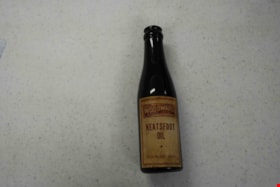
Neatsfoot oil
https://search.heritageburnaby.ca/link/museumartifact90304
- Repository
- Burnaby Village Museum
- Accession Code
- BV020.17.2
- Description
- A dark bootle conatining neatsfoot oil. A yellowed label on the bottle reads "Woodward Store Limited / Neatsfoot Oil / Hardware Dept." The bottle is corked and has some white paint on the opening.
- Object History
- This mask was used by Walter Westerman in the Sperling-Broadway area in Burnaby. Likely for home use. Walter went to school in Burnaby and grew up on Georgia Street. Walter, his wife Gwen and family moved to Duthie Street in Burnaby in 1969. He worked Lenkurt Electric on Lougheed at Bainbridge, as a machinist and was later the foreman of the sheet metal shop.
- Category
- 04.Tools & Equipment for Materials
- Classification
- Leather, Horn & Shellworking T&E
- Marks/Labels
- We Sell Everything / Woodward Stores Limited / The Best for Less / Neatsfoot Oil / Hardware Department
- Colour
- Brown
- Red
- Yellow
- Measurements
- 20 cm h x 5 cm in diameter
- Maker
- Woodward Stores Limited
- Country Made
- England
- Historic Neighbourhood
- Lochdale (Historic Neighbourhood)
- Planning Study Area
- Sperling-Broadway Area
Images
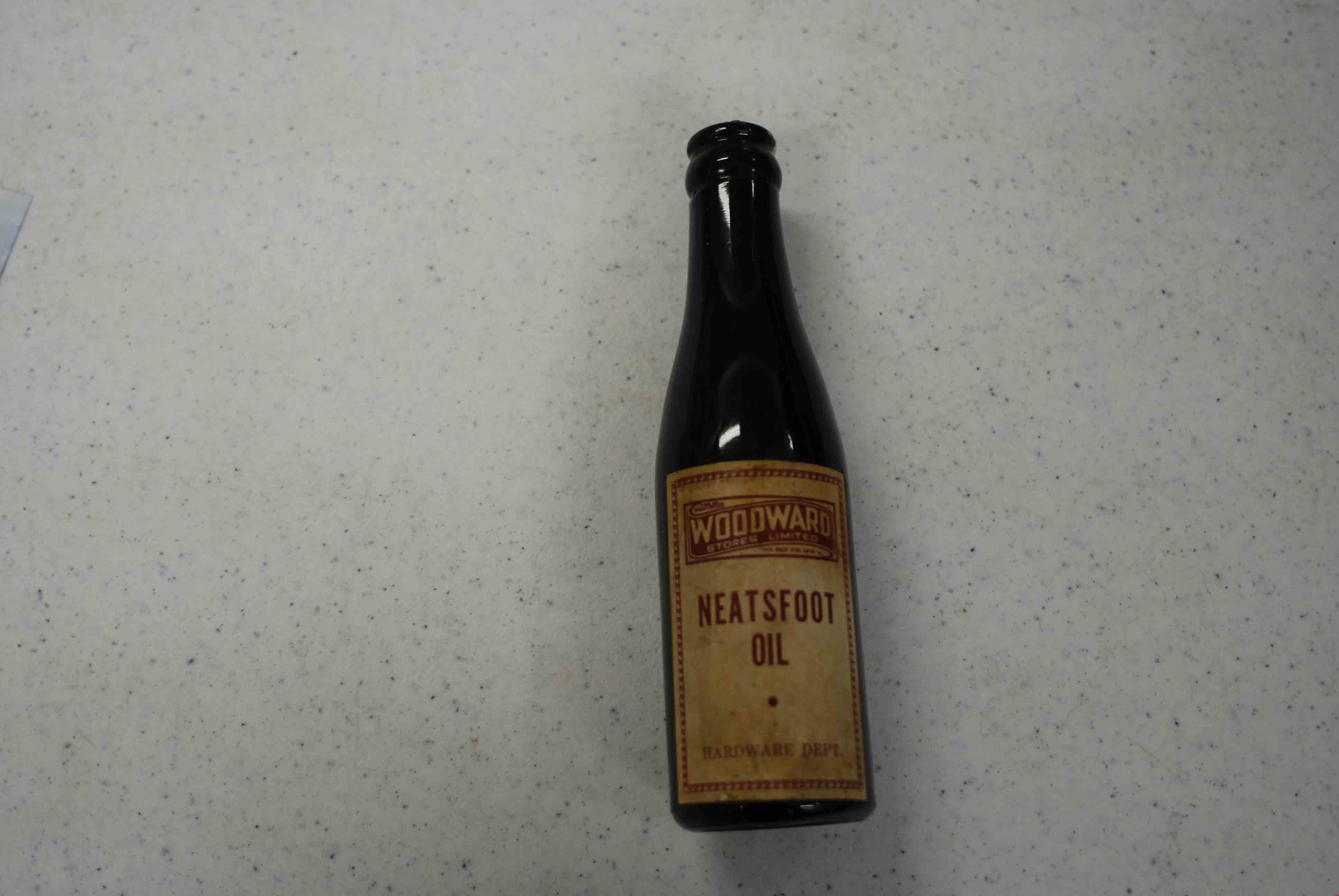

Playground at Sperling Elementary School
https://search.heritageburnaby.ca/link/museumdescription14738
- Repository
- Burnaby Village Museum
- Date
- 9 Apr. 2020
- Collection/Fonds
- Burnaby Village Museum COVID-19 collection
- Description Level
- Item
- Physical Description
- 1 photograph (jpg) : col. ; 72 dpi.
- Scope and Content
- Photograph of the playground outside of Sperling Elementary School in Burnaby. The playground equipment is surrounded by yellow caution tape to prevent anyone from using it. The playground was closed down along with other parks by the City of Burnaby in the spring of 2020 due to the COVID-19 pandem…
- Repository
- Burnaby Village Museum
- Collection/Fonds
- Burnaby Village Museum COVID-19 collection
- Description Level
- Item
- Physical Description
- 1 photograph (jpg) : col. ; 72 dpi.
- Scope and Content
- Photograph of the playground outside of Sperling Elementary School in Burnaby. The playground equipment is surrounded by yellow caution tape to prevent anyone from using it. The playground was closed down along with other parks by the City of Burnaby in the spring of 2020 due to the COVID-19 pandemic and public health orders.
- History
- Tristan Johnson took photos around Burnaby because as a parent of two elementary school aged children during the COVID-19 pandemic, one of the most notable things about COVID-19 during Spring 2020 was the closure of playgrounds and the playgrounds being taped up.
- Names
- Sperling Avenue School
- Accession Code
- BV020.21.3
- Access Restriction
- No restrictions
- Reproduction Restriction
- No known restrictions
- Date
- 9 Apr. 2020
- Media Type
- Photograph
- Historic Neighbourhood
- Lochdale (Historic Neighbourhood)
- Planning Study Area
- Sperling-Broadway Area
- Photographer
- Johnson, Tristan
- Notes
- Title based on contents of photograph
Images


Playground in Montecito Park
https://search.heritageburnaby.ca/link/museumdescription14739
- Repository
- Burnaby Village Museum
- Date
- 9 Apr. 2020
- Collection/Fonds
- Burnaby Village Museum COVID-19 collection
- Description Level
- Item
- Physical Description
- 1 photograph (jpg) : col. ; 72 dpi.
- Scope and Content
- Photograph of the playground inside of Montecito Park in Burnaby. The playground equipment is surrounded by yellow caution tape to prevent anyone from using it. The playground was closed down along with other parks by the City of Burnaby in the spring of 2020 due to the COVID-19 pandemic and public…
- Repository
- Burnaby Village Museum
- Collection/Fonds
- Burnaby Village Museum COVID-19 collection
- Description Level
- Item
- Physical Description
- 1 photograph (jpg) : col. ; 72 dpi.
- Scope and Content
- Photograph of the playground inside of Montecito Park in Burnaby. The playground equipment is surrounded by yellow caution tape to prevent anyone from using it. The playground was closed down along with other parks by the City of Burnaby in the spring of 2020 due to the COVID-19 pandemic and public health orders.
- History
- Tristan Johnson took photos around Burnaby because as a parent of two elementary school aged children during the COVID-19 pandemic, one of the most notable things about COVID-19 during Spring 2020 was the closure of playgrounds and the playgrounds being taped up.
- Names
- Sperling Avenue School
- Accession Code
- BV020.21.4
- Access Restriction
- No restrictions
- Reproduction Restriction
- No known restrictions
- Date
- 9 Apr. 2020
- Media Type
- Photograph
- Historic Neighbourhood
- Lochdale (Historic Neighbourhood)
- Planning Study Area
- Sperling-Broadway Area
- Photographer
- Johnson, Tristan
- Notes
- Title based on contents of photograph
Images

Playground in Squint Lake Park
https://search.heritageburnaby.ca/link/museumdescription14736
- Repository
- Burnaby Village Museum
- Date
- 9 Apr. 2020
- Collection/Fonds
- Burnaby Village Museum COVID-19 collection
- Description Level
- Item
- Physical Description
- 1 photograph (jpg) : col. ; 72 dpi.
- Scope and Content
- Photograph of the Squint Lake Park playground. The playground equipment is surrounded by orange construction fencing to prevent childlren from playing on it. The playground was closed down by the City of Burnaby in the spring of 2020 due to the COVID-19 pandemic and public health orders.
- Repository
- Burnaby Village Museum
- Collection/Fonds
- Burnaby Village Museum COVID-19 collection
- Description Level
- Item
- Physical Description
- 1 photograph (jpg) : col. ; 72 dpi.
- Scope and Content
- Photograph of the Squint Lake Park playground. The playground equipment is surrounded by orange construction fencing to prevent childlren from playing on it. The playground was closed down by the City of Burnaby in the spring of 2020 due to the COVID-19 pandemic and public health orders.
- History
- Tristan Johnson took photos around Burnaby because as a parent of two elementary school aged children during the COVID-19 pandemic, one of the most notable things about COVID-19 during Spring 2020 was the closure of playgrounds and the playgrounds being taped up.
- Accession Code
- BV020.21.1
- Access Restriction
- No restrictions
- Reproduction Restriction
- No known restrictions
- Date
- 9 Apr. 2020
- Media Type
- Photograph
- Planning Study Area
- Sperling-Broadway Area
- Photographer
- Johnson, Tristan
- Notes
- Title based on contents of photograph
Images
Presentations at Centennial '71 Golf Tournament
https://search.heritageburnaby.ca/link/museumdescription13298
- Repository
- Burnaby Village Museum
- Date
- 11 Sept 1971
- Collection/Fonds
- Donald Copan collection
- Description Level
- Item
- Physical Description
- 1 photograph : b&w ; 8.9 x 12.7 cm
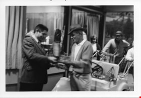
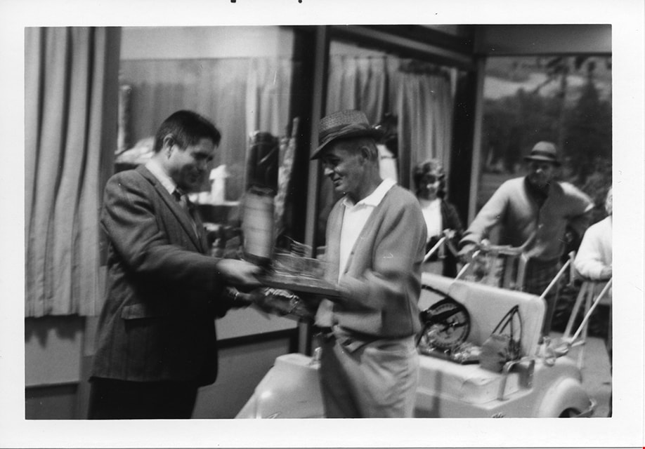
- Scope and Content
- Photograph of an unidentified man presenting a prize to a golfer during the Centennial '71 Golf Tournament which took place at Burnaby Mountain Golf Course on September 11, 1971.
- Repository
- Burnaby Village Museum
- Collection/Fonds
- Donald Copan collection
- Series
- Copan album series
- Description Level
- Item
- Physical Description
- 1 photograph : b&w ; 8.9 x 12.7 cm
- Scope and Content
- Photograph of an unidentified man presenting a prize to a golfer during the Centennial '71 Golf Tournament which took place at Burnaby Mountain Golf Course on September 11, 1971.
- Geographic Access
- Halifax Street
- Street Address
- 7600 Halifax Street
- Accession Code
- BV005.54.314
- Access Restriction
- No restrictions
- Reproduction Restriction
- May be restricted by third party rights
- Date
- 11 Sept 1971
- Media Type
- Photograph
- Historic Neighbourhood
- Lochdale (Historic Neighbourhood)
- Planning Study Area
- Sperling-Broadway Area
- Scan Resolution
- 600
- Scan Date
- July 23, 2020
- Scale
- 100
- Notes
- Title based on contents of photograph
Images

Sperling Avenue School site
https://search.heritageburnaby.ca/link/museumdescription11137
- Repository
- Burnaby Village Museum
- Date
- March 8, 1915
- Collection/Fonds
- Ronald G. Scobbie collection
- Description Level
- Item
- Physical Description
- 1 survey plan : blueprint on paper ; 56 x 54 cm
- Scope and Content
- Survey plan of "Sperling Avenue School Site / Burnaby Municipality" "Being a 4.11 acre portion of the south half of Block 7 of subd. part of Lot 131, Grroup 1" "New Westminster District".
- Repository
- Burnaby Village Museum
- Collection/Fonds
- Ronald G. Scobbie collection
- Description Level
- Item
- Physical Description
- 1 survey plan : blueprint on paper ; 56 x 54 cm
- Material Details
- Scale 40 feet = 1 inch
- Scope and Content
- Survey plan of "Sperling Avenue School Site / Burnaby Municipality" "Being a 4.11 acre portion of the south half of Block 7 of subd. part of Lot 131, Grroup 1" "New Westminster District".
- Creator
- McGugan, Donald Johnston
- Subjects
- Buildings - Schools
- Names
- Sperling Avenue School
- Responsibility
- Burnett & McGugan, Engineers and Surveyors
- Geographic Access
- Sperling Avenue
- Street Address
- 2200 Sperling Avenue
- Accession Code
- BV003.83.16
- Access Restriction
- No restrictions
- Reproduction Restriction
- No known restrictions
- Date
- March 8, 1915
- Media Type
- Cartographic Material
- Historic Neighbourhood
- Lochdale (Historic Neighbourhood)
- Planning Study Area
- Sperling-Broadway Area
- Scan Resolution
- 440
- Scan Date
- 22-Dec-2020
- Scale
- 100
- Notes
- Title based on contents of plan
- handwritten on back, "1748"
- Oath on plan reads: "I, D.G. McGugan..." "...person- ally superintend the survey..." "...completed on the 8th day of March 1915"; signed by D.J. McGugan, notarized by "R.E. Chapman", sworn "...12th day of April 1915" "Burnett and McGugan" "B.C. Land Surveyors Etc. New Westminster, B.C..";
Images

Trophies for Centennial '71 Golf Tournament
https://search.heritageburnaby.ca/link/museumdescription13300
- Repository
- Burnaby Village Museum
- Date
- 11 Sept 1971
- Collection/Fonds
- Donald Copan collection
- Description Level
- Item
- Physical Description
- 1 photograph : col. ; 8.9 x 8.9 cm
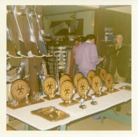
- Scope and Content
- Photograph of a display of trophies and awards for the Centennial '71 Golf Tournament which took place at Burnaby Mountain Golf Course on September 11, 1971.
- Repository
- Burnaby Village Museum
- Collection/Fonds
- Donald Copan collection
- Series
- Copan album series
- Description Level
- Item
- Physical Description
- 1 photograph : col. ; 8.9 x 8.9 cm
- Scope and Content
- Photograph of a display of trophies and awards for the Centennial '71 Golf Tournament which took place at Burnaby Mountain Golf Course on September 11, 1971.
- Geographic Access
- Halifax Street
- Street Address
- 7600 Halifax Street
- Accession Code
- BV005.54.316
- Access Restriction
- No restrictions
- Reproduction Restriction
- May be restricted by third party rights
- Date
- 11 Sept 1971
- Media Type
- Photograph
- Historic Neighbourhood
- Lochdale (Historic Neighbourhood)
- Planning Study Area
- Sperling-Broadway Area
- Scan Resolution
- 600
- Scan Date
- July 23, 2020
- Scale
- 100
- Notes
- Title based on contents of photograph
Images

![Wally Westerman shovelling snow in front of his house, [198-] thumbnail](/media/hpo/_Data/_BVM_Images/2020/2020_0017_0019_001.jpg?width=280)
Wally Westerman shovelling snow in front of his house
https://search.heritageburnaby.ca/link/museumdescription13695
- Repository
- Burnaby Village Museum
- Date
- [198-]
- Collection/Fonds
- Westerman family fonds
- Description Level
- Item
- Physical Description
- 1 photograph : col. ; 10 x 15 cm
- Scope and Content
- Photograph of Walter "Wally" Westerman shovelling snow in front of his house at 2171 Duthie Avenue in Burnaby.
- Repository
- Burnaby Village Museum
- Collection/Fonds
- Westerman family fonds
- Description Level
- Item
- Physical Description
- 1 photograph : col. ; 10 x 15 cm
- Material Details
- `
- Scope and Content
- Photograph of Walter "Wally" Westerman shovelling snow in front of his house at 2171 Duthie Avenue in Burnaby.
- Geographic Access
- Duthie Avenue
- Street Address
- 2171 Duthie Avenue
- Accession Code
- BV020.17.19
- Access Restriction
- No restrictions
- Reproduction Restriction
- No known restrictions
- Date
- [198-]
- Media Type
- Photograph
- Planning Study Area
- Sperling-Broadway Area
- Scan Resolution
- 600
- Scan Date
- 22-Sep-2020
- Scale
- 100
- Notes
- Title based on contents of photograph
- Handwritten note in pencil on verso of photograph reads: "Walter aged 11/ May 21st 1928"
Images
![Wally Westerman shovelling snow in front of his house, [198-] thumbnail](/media/hpo/_Data/_BVM_Images/2020/2020_0017_0019_001.jpg)