Narrow Results By

Sperling Avenue School
https://search.heritageburnaby.ca/link/landmark744
- Repository
- Burnaby Heritage Planning
- Geographic Access
- Sperling Avenue
- Associated Dates
- 1914
- Heritage Value
- The Sperling Avenue School was opened in 1914 to service the growing community around the B.C. Electric Company's Pole Line Road (Sperling Avenue). This school replaced the one-room Duthie schoolhouse.
- Historic Neighbourhood
- Lochdale (Historic Neighbourhood)
- Planning Study Area
- Sperling-Broadway Area
- Street Address
- 2200 Sperling Avenue
- Street View URL
- Google Maps Street View
Images


Sperling-Broadway Neighbourhood
https://search.heritageburnaby.ca/link/landmark789
- Repository
- Burnaby Heritage Planning
- Associated Dates
- 1955-2008
- Heritage Value
- By the 1970s, the Sperling-Broadway Neighbourhood was characterised as one of the Municipality's fastest growing residential areas. In 1980, it was estimated that slightly less than half of the homes were single-family residences, while the remaining development was taking the form of townhouse and high-rise apartments. The emphasis shifted back to single family housing during the construction of planned subdivisions such as the Camrose subdivision in the 1980s and the area remains primarily residential in nature. The neighbourhood is well-served by park facilities and is also home to the Burnaby Mountain Golf Course.
- Historic Neighbourhood
- Lochdale (Historic Neighbourhood)
- Planning Study Area
- Sperling-Broadway Area
Images

Aerial photograph of Burnaby
https://search.heritageburnaby.ca/link/archivedescription84892
- Repository
- City of Burnaby Archives
- Date
- 1963
- Collection/Fonds
- Allan Amundsen collection
- Description Level
- Item
- Physical Description
- 1 photograph : b&w ; 22.5 x 22.5 cm
- Scope and Content
- Aerial photograph of Burnaby north of Lougheed Highway.
- Repository
- City of Burnaby Archives
- Date
- 1963
- Collection/Fonds
- Allan Amundsen collection
- Physical Description
- 1 photograph : b&w ; 22.5 x 22.5 cm
- Description Level
- Item
- Record No.
- 561-013
- Access Restriction
- In Archives only
- Reproduction Restriction
- No reproduction permitted
- Accession Number
- 2014-08
- Scope and Content
- Aerial photograph of Burnaby north of Lougheed Highway.
- Subjects
- Aerial Photographs
- Media Type
- Photograph
- Photographer
- Province of British Columbia
- Notes
- Title based on contents of photograph
- This photo is indentified as BC5061:118 and connects with B.C. air photograph BC5061:117 to the west and BC5061:119 to the east
- Historic Neighbourhood
- Burnaby Lake (Historic Neighbourhood)
- Lozells (Historic Neighbourhood)
- Planning Study Area
- Parkcrest-Aubrey Area
- Ardingley-Sprott Area
- Sperling-Broadway Area
- Government Road Area
Aerial photograph of Burnaby
https://search.heritageburnaby.ca/link/archivedescription84893
- Repository
- City of Burnaby Archives
- Date
- 1963
- Collection/Fonds
- Allan Amundsen collection
- Description Level
- Item
- Physical Description
- 1 photograph : b&w ; 22.5 x 22.5 cm
- Scope and Content
- Aerial photograph of Burnaby north of Lougheed Highway and west of Sperling Avenue.
- Repository
- City of Burnaby Archives
- Date
- 1963
- Collection/Fonds
- Allan Amundsen collection
- Physical Description
- 1 photograph : b&w ; 22.5 x 22.5 cm
- Description Level
- Item
- Record No.
- 561-014
- Access Restriction
- In Archives only
- Reproduction Restriction
- No reproduction permitted
- Accession Number
- 2014-08
- Scope and Content
- Aerial photograph of Burnaby north of Lougheed Highway and west of Sperling Avenue.
- Subjects
- Aerial Photographs
- Media Type
- Photograph
- Photographer
- Province of British Columbia
- Notes
- Title based on contents of photograph
- This photo is indentified as BC5061:119 and connects with B.C. air photograph BC5061:118 to the west and BC5061:120 to the east
- Geographic Access
- Burnaby Mountain Conservation Area
- Historic Neighbourhood
- Lozells (Historic Neighbourhood)
- Planning Study Area
- Sperling-Broadway Area
- Lake City Area
- Government Road Area
Aerial photograph of Burnaby
https://search.heritageburnaby.ca/link/archivedescription84894
- Repository
- City of Burnaby Archives
- Date
- 1963
- Collection/Fonds
- Allan Amundsen collection
- Description Level
- Item
- Physical Description
- 1 photograph : b&w ; 22.5 x 22.5 cm
- Scope and Content
- Aerial photograph of Burnaby north of Broadway and west of Sperling Avenue.
- Repository
- City of Burnaby Archives
- Date
- 1963
- Collection/Fonds
- Allan Amundsen collection
- Physical Description
- 1 photograph : b&w ; 22.5 x 22.5 cm
- Description Level
- Item
- Record No.
- 561-015
- Access Restriction
- In Archives only
- Reproduction Restriction
- No reproduction permitted
- Accession Number
- 2014-08
- Scope and Content
- Aerial photograph of Burnaby north of Broadway and west of Sperling Avenue.
- Subjects
- Aerial Photographs
- Media Type
- Photograph
- Photographer
- Province of British Columbia
- Notes
- Title based on contents of photograph
- This photo is indentified as BC5061:120 and connects with B.C. air photograph BC5061:119 to the west and BC5061:121 to the east
- Geographic Access
- Burnaby Mountain Conservation Area
- Historic Neighbourhood
- Lozells (Historic Neighbourhood)
- Planning Study Area
- Sperling-Broadway Area
- Lake City Area
- Government Road Area
- Burnaby Mountain Area
Aerial photograph of Burnaby
https://search.heritageburnaby.ca/link/archivedescription84896
- Repository
- City of Burnaby Archives
- Date
- 1963
- Collection/Fonds
- Allan Amundsen collection
- Description Level
- Item
- Physical Description
- 1 photograph : b&w ; 22.5 x 22.5 cm
- Scope and Content
- Aerial photograph of Burnaby north of Broadway and west of Sperling Avenue.
- Repository
- City of Burnaby Archives
- Date
- 1963
- Collection/Fonds
- Allan Amundsen collection
- Physical Description
- 1 photograph : b&w ; 22.5 x 22.5 cm
- Description Level
- Item
- Record No.
- 561-016
- Access Restriction
- In Archives only
- Reproduction Restriction
- No reproduction permitted
- Accession Number
- 2014-08
- Scope and Content
- Aerial photograph of Burnaby north of Broadway and west of Sperling Avenue.
- Subjects
- Aerial Photographs
- Media Type
- Photograph
- Photographer
- Province of British Columbia
- Notes
- Title based on contents of photograph
- This photo is indentified as BC5061:121 and connects with B.C. air photograph BC5061:120 to the west and BC5061:122 to the east
- Geographic Access
- Burnaby Mountain Conservation Area
- Historic Neighbourhood
- Lozells (Historic Neighbourhood)
- Planning Study Area
- Sperling-Broadway Area
- Lake City Area
- Government Road Area
- Burnaby Mountain Area
Aerial photograph of Burnaby Lake Area
https://search.heritageburnaby.ca/link/archivedescription84908
- Repository
- City of Burnaby Archives
- Date
- 1963
- Collection/Fonds
- Allan Amundsen collection
- Description Level
- Item
- Physical Description
- 1 photograph : b&w ; 22.5 x 22.5 cm
- Scope and Content
- Aerial photograph of Burnaby with Lougheed Highway in the north west corner, the Trans Canada Highway in the south east corner and Burnaby Lake appearing from the west.
- Repository
- City of Burnaby Archives
- Date
- 1963
- Collection/Fonds
- Allan Amundsen collection
- Physical Description
- 1 photograph : b&w ; 22.5 x 22.5 cm
- Description Level
- Item
- Record No.
- 561-026
- Access Restriction
- In Archives only
- Reproduction Restriction
- No reproduction permitted
- Accession Number
- 2014-08
- Scope and Content
- Aerial photograph of Burnaby with Lougheed Highway in the north west corner, the Trans Canada Highway in the south east corner and Burnaby Lake appearing from the west.
- Subjects
- Aerial Photographs
- Media Type
- Photograph
- Photographer
- Province of British Columbia
- Notes
- Title based on contents of photograph
- This photo is indentified as BC5062:25 and connects with B.C. air photograph BC5062:26 to the west and B.C. air photograph BC5062:24 to the east
- Historic Neighbourhood
- Burnaby Lake (Historic Neighbourhood)
- Lozells (Historic Neighbourhood)
- Planning Study Area
- Douglas-Gilpin Area
- Sperling-Broadway Area
- Government Road Area
- Burnaby Lake Area
Aerial photograph of Burnaby Lake Area
https://search.heritageburnaby.ca/link/archivedescription84909
- Repository
- City of Burnaby Archives
- Date
- 1963
- Collection/Fonds
- Allan Amundsen collection
- Description Level
- Item
- Physical Description
- 1 photograph : b&w ; 22.5 x 22.5 cm
- Scope and Content
- Aerial photograph of Burnaby with Lougheed Highway to the north and Burnaby Lake to the south.
- Repository
- City of Burnaby Archives
- Date
- 1963
- Collection/Fonds
- Allan Amundsen collection
- Physical Description
- 1 photograph : b&w ; 22.5 x 22.5 cm
- Description Level
- Item
- Record No.
- 561-027
- Access Restriction
- In Archives only
- Reproduction Restriction
- No reproduction permitted
- Accession Number
- 2014-08
- Scope and Content
- Aerial photograph of Burnaby with Lougheed Highway to the north and Burnaby Lake to the south.
- Subjects
- Aerial Photographs
- Media Type
- Photograph
- Photographer
- Province of British Columbia
- Notes
- Title based on contents of photograph
- This photo is indentified as BC5062:24 and connects with B.C. air photograph BC5062:25 to the west and B.C. air photograph BC5062:23 to the east
- Historic Neighbourhood
- Burnaby Lake (Historic Neighbourhood)
- Lozells (Historic Neighbourhood)
- Planning Study Area
- Douglas-Gilpin Area
- Sperling-Broadway Area
- Government Road Area
- Burnaby Lake Area
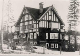
![Gavin House, [after 1911] thumbnail](/media/hpo/_Data/_Archives_Images/_Unrestricted/205/241-031.jpg?width=280)
Gavin House
https://search.heritageburnaby.ca/link/archivedescription51363
- Repository
- City of Burnaby Archives
- Date
- [after 1911]
- Collection/Fonds
- Burnaby Historical Society fonds
- Description Level
- Item
- Physical Description
- 1 photograph : b&w copy negative ; 2 x 3.5 cm
- Scope and Content
- Photograph of the Gavin House taken from a distance at a 3/4 view. Fence posts are visible. This home was designed by architect A. C. Hope.
- Repository
- City of Burnaby Archives
- Date
- [after 1911]
- Collection/Fonds
- Burnaby Historical Society fonds
- Subseries
- Burnaby Art Gallery subseries
- Physical Description
- 1 photograph : b&w copy negative ; 2 x 3.5 cm
- Description Level
- Item
- Record No.
- 241-031
- Access Restriction
- No restrictions
- Reproduction Restriction
- No known restrictions
- Accession Number
- BHS1990-05
- Scope and Content
- Photograph of the Gavin House taken from a distance at a 3/4 view. Fence posts are visible. This home was designed by architect A. C. Hope.
- Subjects
- Buildings - Residential - Houses
- Media Type
- Photograph
- Notes
- Title based on contents of photograph
- Geographic Access
- Buckingham Avenue
- Sperling Avenue
- Historic Neighbourhood
- Burnaby Lake (Historic Neighbourhood)
- Planning Study Area
- Sperling-Broadway Area
Images
![Gavin House, [after 1911] thumbnail](/media/hpo/_Data/_Archives_Images/_Unrestricted/205/241-031.jpg)
Gavin house
https://search.heritageburnaby.ca/link/archivedescription36002
- Repository
- City of Burnaby Archives
- Date
- 1912
- Collection/Fonds
- Burnaby Historical Society fonds
- Description Level
- Item
- Physical Description
- 1 photograph : b&w ; 8.5 x 12.5 cm print
- Scope and Content
- Photograph of the Gavin house located on Buckingham Road at Sperling. The house was designed by architect A.C. Hope and built for Francis John Gavin and his family.
- Repository
- City of Burnaby Archives
- Date
- 1912
- Collection/Fonds
- Burnaby Historical Society fonds
- Subseries
- Gavin family subseries
- Physical Description
- 1 photograph : b&w ; 8.5 x 12.5 cm print
- Description Level
- Item
- Record No.
- 209-001
- Access Restriction
- No restrictions
- Reproduction Restriction
- No known restrictions
- Accession Number
- BHS1988-09
- Scope and Content
- Photograph of the Gavin house located on Buckingham Road at Sperling. The house was designed by architect A.C. Hope and built for Francis John Gavin and his family.
- Subjects
- Buildings - Residential - Houses
- Media Type
- Photograph
- Notes
- Title based on contents of photograph
- Geographic Access
- Buckingham Avenue
- Sperling Avenue
- Historic Neighbourhood
- Lochdale (Historic Neighbourhood)
- Planning Study Area
- Sperling-Broadway Area
Images

![Grade 3, Division 8, [1960 or 1961] thumbnail](/media/hpo/_Data/_Archives_Images/_Unrestricted/371/463-013.jpg?width=280)
Grade 3, Division 8
https://search.heritageburnaby.ca/link/archivedescription38575
- Repository
- City of Burnaby Archives
- Date
- [1960 or 1961]
- Collection/Fonds
- Burnaby Historical Society fonds
- Description Level
- Item
- Physical Description
- 1 photograph : b&w ; 12.5 x 17.5 cm
- Scope and Content
- Photograph of the Grade 3, Division 8 class at Sperling Avenue School. All of the thirty-five children and one teacher pictured are unidentified; the other teacher is Mrs. V. Cuthbertson. The picture appears to have been taken in the school gymnasium and a sign placed in front of the group reads:…
- Repository
- City of Burnaby Archives
- Date
- [1960 or 1961]
- Collection/Fonds
- Burnaby Historical Society fonds
- Subseries
- Photographs subseries
- Physical Description
- 1 photograph : b&w ; 12.5 x 17.5 cm
- Description Level
- Item
- Record No.
- 463-013
- Access Restriction
- No restrictions
- Reproduction Restriction
- Reproduce for fair dealing purposes only
- Accession Number
- BHS2007-04
- Scope and Content
- Photograph of the Grade 3, Division 8 class at Sperling Avenue School. All of the thirty-five children and one teacher pictured are unidentified; the other teacher is Mrs. V. Cuthbertson. The picture appears to have been taken in the school gymnasium and a sign placed in front of the group reads: "Sperling Ave. Elem. Gr 3 Div 8, 1960-1961."
- Subjects
- Occupations - Teachers
- Names
- Sperling Avenue School
- Media Type
- Photograph
- Notes
- Title based on contents of photograph
- Geographic Access
- Sperling Avenue
- Street Address
- 2200 Sperling Avenue
- Historic Neighbourhood
- Lochdale (Historic Neighbourhood)
- Planning Study Area
- Sperling-Broadway Area
Images
![Grade 3, Division 8, [1960 or 1961] thumbnail](/media/hpo/_Data/_Archives_Images/_Unrestricted/371/463-013.jpg)
![Grade 3, Division 8, [1961 or 1962] thumbnail](/media/hpo/_Data/_Archives_Images/_Unrestricted/371/463-015.jpg?width=280)
Grade 3, Division 8
https://search.heritageburnaby.ca/link/archivedescription38577
- Repository
- City of Burnaby Archives
- Date
- [1961 or 1962]
- Collection/Fonds
- Burnaby Historical Society fonds
- Description Level
- Item
- Physical Description
- 1 photograph : b&w ; 12.5 x 17.5 cm
- Scope and Content
- Photograph of the Grade 3, Division 8 class at Sperling Avenue School. The children are unidentified and the teacher is Mrs. V. Cuthbertson.
- Repository
- City of Burnaby Archives
- Date
- [1961 or 1962]
- Collection/Fonds
- Burnaby Historical Society fonds
- Subseries
- Photographs subseries
- Physical Description
- 1 photograph : b&w ; 12.5 x 17.5 cm
- Description Level
- Item
- Record No.
- 463-015
- Access Restriction
- No restrictions
- Reproduction Restriction
- Reproduce for fair dealing purposes only
- Accession Number
- BHS2007-04
- Scope and Content
- Photograph of the Grade 3, Division 8 class at Sperling Avenue School. The children are unidentified and the teacher is Mrs. V. Cuthbertson.
- Subjects
- Occupations - Teachers
- Names
- Sperling Avenue School
- Media Type
- Photograph
- Notes
- Title based on contents of photograph
- Geographic Access
- Sperling Avenue
- Street Address
- 2200 Sperling Avenue
- Historic Neighbourhood
- Lochdale (Historic Neighbourhood)
- Planning Study Area
- Sperling-Broadway Area
Images
![Grade 3, Division 8, [1961 or 1962] thumbnail](/media/hpo/_Data/_Archives_Images/_Unrestricted/371/463-015.jpg)
![Hamilton Road School, [between 1911 and 1919] thumbnail](/media/hpo/_Data/_Archives_Images/_Unrestricted/316/325-036.jpg?width=280)
Hamilton Road School
https://search.heritageburnaby.ca/link/archivedescription37164
- Repository
- City of Burnaby Archives
- Date
- [between 1911 and 1919]
- Collection/Fonds
- Burnaby Historical Society fonds
- Description Level
- Item
- Physical Description
- 1 photograph : b&w ; 8 x 12.5 cm print
- Scope and Content
- Photograph of Hamilton Road School taken from a distance.
- Repository
- City of Burnaby Archives
- Date
- [between 1911 and 1919]
- Collection/Fonds
- Burnaby Historical Society fonds
- Subseries
- Disney family subseries
- Physical Description
- 1 photograph : b&w ; 8 x 12.5 cm print
- Description Level
- Item
- Record No.
- 325-036
- Access Restriction
- No restrictions
- Reproduction Restriction
- No known restrictions
- Accession Number
- BHS1996-04
- Scope and Content
- Photograph of Hamilton Road School taken from a distance.
- Subjects
- Buildings - Schools
- Names
- Hamilton Road School
- Media Type
- Photograph
- Photographer
- Disney, John Harold "Jack"
- Notes
- Title based on contents of photograph
- Geographic Access
- Lyndhurst Street
- Historic Neighbourhood
- Burquitlam (Historic Neighbourhood)
- Planning Study Area
- Sperling-Broadway Area
Images
![Hamilton Road School, [between 1911 and 1919] thumbnail](/media/hpo/_Data/_Archives_Images/_Unrestricted/316/325-036.jpg)

Hamilton Road School site
https://search.heritageburnaby.ca/link/museumdescription11139
- Repository
- Burnaby Village Museum
- Date
- April 27, 1915
- Collection/Fonds
- Ronald G. Scobbie collection
- Description Level
- Item
- Physical Description
- 1 survey plan : blueprint on paper ; 56 x 54 cm
- Scope and Content
- Survey plan of "Hamilton Road School Site / Burnaby Municipality" "Being the westerly 2 acres of Block 2 of the subd. of a portion of Lot 8, Group 1"; "New Westminster District”.
- Repository
- Burnaby Village Museum
- Collection/Fonds
- Ronald G. Scobbie collection
- Description Level
- Item
- Physical Description
- 1 survey plan : blueprint on paper ; 56 x 54 cm
- Material Details
- Scale 40 feet = 1 inch
- Scope and Content
- Survey plan of "Hamilton Road School Site / Burnaby Municipality" "Being the westerly 2 acres of Block 2 of the subd. of a portion of Lot 8, Group 1"; "New Westminster District”.
- Creator
- Burnett, Geoffrey K.
- Subjects
- Buildings - Schools
- Names
- Hamilton Road School
- Responsibility
- Burnett & McGugan, Engineers and Surveyors
- Geographic Access
- Lyndhurst Street
- Accession Code
- BV003.83.18
- Access Restriction
- No restrictions
- Reproduction Restriction
- No known restrictions
- Date
- April 27, 1915
- Media Type
- Cartographic Material
- Historic Neighbourhood
- Burquitlam (Historic Neighbourhood)
- Planning Study Area
- Sperling-Broadway Area
- Scan Resolution
- 440
- Scan Date
- 22-Dec-2020
- Scale
- 100
- Notes
- Title based on contents of plan
- handwritten on back, "1752" and mathematical calculations
- Oath on plan reads: "I, Geoffrey K. Burnett...and did person- ally superintend the survey..." "...completed on the 27th day of April 1915"; signed by Geoffrey K. Burnett, notary illegible, sworn "...27th day of April 1915" "Burnett and McGugan" "B.C. Land Surveyors Etc. New Westminster, B.C."
Images

![In front of Duthie School, [between 1911 and 1919] thumbnail](/media/hpo/_Data/_Archives_Images/_Unrestricted/316/325-031.jpg?width=280)
In front of Duthie School
https://search.heritageburnaby.ca/link/archivedescription37159
- Repository
- City of Burnaby Archives
- Date
- [between 1911 and 1919]
- Collection/Fonds
- Burnaby Historical Society fonds
- Description Level
- Item
- Physical Description
- 1 photograph : b&w ; 12.5 x 8 cm print
- Scope and Content
- Photograph of a man with surveyor equipment sitting on the wooden sidewalk in front of Duthie School (also called Johnston Road School). This school existed from 1909 to 1921.
- Repository
- City of Burnaby Archives
- Date
- [between 1911 and 1919]
- Collection/Fonds
- Burnaby Historical Society fonds
- Subseries
- Disney family subseries
- Physical Description
- 1 photograph : b&w ; 12.5 x 8 cm print
- Description Level
- Item
- Record No.
- 325-031
- Access Restriction
- No restrictions
- Reproduction Restriction
- No known restrictions
- Accession Number
- BHS1996-04
- Scope and Content
- Photograph of a man with surveyor equipment sitting on the wooden sidewalk in front of Duthie School (also called Johnston Road School). This school existed from 1909 to 1921.
- Subjects
- Buildings - Schools
- Names
- Duthie School
- Media Type
- Photograph
- Photographer
- Disney, John Harold "Jack"
- Notes
- Title based on contents of photograph
- Geographic Access
- Broadway
- Sperling Avenue
- Historic Neighbourhood
- Lochdale (Historic Neighbourhood)
- Planning Study Area
- Sperling-Broadway Area
Images
![In front of Duthie School, [between 1911 and 1919] thumbnail](/media/hpo/_Data/_Archives_Images/_Unrestricted/316/325-031.jpg)
Interview with Leonard Evenden and Allen Seager by Kathy Bossort November 18, 2015 - Track 1
https://search.heritageburnaby.ca/link/oralhistory621
- Repository
- City of Burnaby Archives
- Date Range
- 1925-2015
- Length
- 0:12:50
- Summary
- This portion of the interview is about Dr. Evenden and Dr. Seager’s description of their early years at Simon Fraser University. They talk about the challenges to commuting up and down Burnaby Mountain and the solutions people used, particularly hitchhiking. Dr. Seager talks about living in Monteci…
- Repository
- City of Burnaby Archives
- Summary
- This portion of the interview is about Dr. Evenden and Dr. Seager’s description of their early years at Simon Fraser University. They talk about the challenges to commuting up and down Burnaby Mountain and the solutions people used, particularly hitchhiking. Dr. Seager talks about living in Montecito in the 1980s. Dr. Evenden talks about the early use of Burnaby Mountain and its undeveloped state when the site for SFU was proposed in 1963.
- Date Range
- 1925-2015
- Length
- 0:12:50
- Names
- Simon Fraser University
- Subjects
- Education
- Transportation
- Geographic Access
- Burnaby Mountain Conservation Area
- Historic Neighbourhood
- Lochdale (Historic Neighbourhood)
- Planning Study Area
- Sperling-Broadway Area
- Interviewer
- Bossort, Kathy
- Interview Date
- November 18, 2015
- Scope and Content
- Recording is of an interview with Dr. Leonard Evenden and Dr. Allen Seager conducted by Kathy Bossort. Leonard Evenden and Allen Seager were two of 23 participants interviewed as part of the Community Heritage Commission’s Burnaby Mountain Oral History Project. The interview is mainly about aspects of Simon Fraser University’s history that is related to its site on Burnaby Mountain, as told by two retired SFU professors, Dr. Evenden of the Geography Department and Dr. Seager of the Department of History. The interview ranges over campus access and housing issues created by the isolated mountain site; the relationship of the university to the local community and the dispute over land ownership and control with the City of Burnaby; SFU’s environmental stewardship; the development of UniverCity; and the future of parkland in the conservation area on Burnaby Mountain.
- Biographical Notes
- Dr. Leonard J. Evenden was born 1937 in Beijing, China, to parents and Salvation Army missionaries Leonard Evenden and Elsie Pearl March. Dr. Evenden attended McMaster University (B.A. 1960), University of Georgia (M.A. 1962) and University of Edinburgh (Ph.D. 1970). He was appointed to Simon Fraser University’s Department of Geography in 1966, shortly after SFU opened in the fall of 1965, and retired in 2002. Dr. Evenden’s research has focused on Canadian urban geography. He edited a collection of essays about Burnaby titled “Suburb of Happy Homes: Burnaby centennial themes” (1995), and directed “Voices of Burnaby”, an SFU/Burnaby Centennial Committee oral history project (1992). Dr. Evenden is married with three children. Dr. Allen Seager was born 1953 in Montreal, Quebec, to parents C.F.B. Seager and Evelyn DeGex Chesam. Dr. Seager is a retired Simon Fraser University professor, being a member of SFU’s Department of History from 1981 to 2014, and has current links with SFU as an instructor for Continuing Studies. His research interests include history of Canada and Western Canada, and labour and working class history, particularly in the coal mining and railway industries. Dr. Seager moved to Burnaby and the Montecito area in 1981 where he continues to live and enjoy the hiking trails on Burnaby Mountain and the amenities at SFU. Dr. Seager is a member of the Burnaby North NDP, and has volunteered with Scouts Canada and the Burnaby Centennial Committee.
- Total Tracks
- 6
- Total Length
- 1:11:28
- Interviewee Name
- Evenden, Leonard J.
- Seager, Allen
- Interview Location
- Clubhouse at Burnaby Mountain Golf Course Restaurant
- Interviewer Bio
- Kathy Bossort is a retired archivist living in Ladner, BC. She worked at the Delta Museum and Archives after graduating from SLAIS (UBC) in 2001 with Masters degrees in library science and archival studies. Kathy grew up in Calgary, Alberta, and, prior to this career change, she lived in the West Kootenays, earning her living as a cook for BC tourist lodges and work camps. She continues to be interested in oral histories as a way to fill the gaps in the written record and bring richer meaning to history.
- Collection/Fonds
- Community Heritage Commission Special Projects fonds
- Media Type
- Sound Recording
Audio Tracks
Track one of interview with Dr. Leonard Evenden and Dr. Allen Seager
Track one of interview with Dr. Leonard Evenden and Dr. Allen Seager
https://search.heritageburnaby.ca/media/hpo/_Data/_Archives_Oral_Histories/_Unrestricted/MSS196-011/MSS196-011_Track_1.mp3![Johnston Road School, [between 1911 and 1919] thumbnail](/media/hpo/_Data/_Archives_Images/_Unrestricted/316/325-030.jpg?width=280)
Johnston Road School
https://search.heritageburnaby.ca/link/archivedescription37158
- Repository
- City of Burnaby Archives
- Date
- [between 1911 and 1919]
- Collection/Fonds
- Burnaby Historical Society fonds
- Description Level
- Item
- Physical Description
- 1 photograph : b&w ; 7.5 x 12.5 cm print
- Scope and Content
- Photograph of Johnston Road School (also called Duthie School) taken from Broadway. This school existed from 1909 to 1921.
- Repository
- City of Burnaby Archives
- Date
- [between 1911 and 1919]
- Collection/Fonds
- Burnaby Historical Society fonds
- Subseries
- Disney family subseries
- Physical Description
- 1 photograph : b&w ; 7.5 x 12.5 cm print
- Description Level
- Item
- Record No.
- 325-030
- Access Restriction
- No restrictions
- Reproduction Restriction
- No known restrictions
- Accession Number
- BHS1996-04
- Scope and Content
- Photograph of Johnston Road School (also called Duthie School) taken from Broadway. This school existed from 1909 to 1921.
- Subjects
- Buildings - Schools
- Media Type
- Photograph
- Photographer
- Disney, John Harold "Jack"
- Notes
- Title based on contents of photograph
- Geographic Access
- Broadway
- Sperling Avenue
- Historic Neighbourhood
- Lochdale (Historic Neighbourhood)
- Planning Study Area
- Sperling-Broadway Area
Images
![Johnston Road School, [between 1911 and 1919] thumbnail](/media/hpo/_Data/_Archives_Images/_Unrestricted/316/325-030.jpg)
![Path to Hamilton Road School, [between 1911 and 1919] thumbnail](/media/hpo/_Data/_Archives_Images/_Unrestricted/316/325-042.jpg?width=280)
Path to Hamilton Road School
https://search.heritageburnaby.ca/link/archivedescription37170
- Repository
- City of Burnaby Archives
- Date
- [between 1911 and 1919]
- Collection/Fonds
- Burnaby Historical Society fonds
- Description Level
- Item
- Physical Description
- 1 photograph : b&w ; 8.5 x 12.5 cm print
- Scope and Content
- Photograph of Hamilton Road School taken from a distance, with a visible path leading up to the school.
- Repository
- City of Burnaby Archives
- Date
- [between 1911 and 1919]
- Collection/Fonds
- Burnaby Historical Society fonds
- Subseries
- Disney family subseries
- Physical Description
- 1 photograph : b&w ; 8.5 x 12.5 cm print
- Description Level
- Item
- Record No.
- 325-042
- Access Restriction
- No restrictions
- Reproduction Restriction
- No known restrictions
- Accession Number
- BHS1996-04
- Scope and Content
- Photograph of Hamilton Road School taken from a distance, with a visible path leading up to the school.
- Subjects
- Buildings - Schools
- Names
- Hamilton Road School
- Media Type
- Photograph
- Photographer
- Disney, John Harold "Jack"
- Notes
- Title based on contents of photograph
- Geographic Access
- Lyndhurst Street
- Historic Neighbourhood
- Burquitlam (Historic Neighbourhood)
- Planning Study Area
- Sperling-Broadway Area
Images
![Path to Hamilton Road School, [between 1911 and 1919] thumbnail](/media/hpo/_Data/_Archives_Images/_Unrestricted/316/325-042.jpg)
Sperling Avenue School during construction
https://search.heritageburnaby.ca/link/archivedescription36027
- Repository
- City of Burnaby Archives
- Date
- 1913
- Collection/Fonds
- Burnaby Historical Society fonds
- Description Level
- Item
- Physical Description
- 1 photograph : sepia
- Scope and Content
- Photograph of the Sperling Avenue School during construction. This was the first school ever built by Bruce Patterson.
- Repository
- City of Burnaby Archives
- Date
- 1913
- Collection/Fonds
- Burnaby Historical Society fonds
- Subseries
- Patterson family subseries
- Physical Description
- 1 photograph : sepia
- Description Level
- Item
- Record No.
- 213-009
- Access Restriction
- No restrictions
- Reproduction Restriction
- No known restrictions
- Accession Number
- BHS1988-13
- Scope and Content
- Photograph of the Sperling Avenue School during construction. This was the first school ever built by Bruce Patterson.
- Media Type
- Photograph
- Notes
- Title based on contents of photograph
- Hand written note on verso of photograph reads: "1st School Bruce built"
- Geographic Access
- Sperling Avenue
- Street Address
- 2200 Sperling Avenue
- Historic Neighbourhood
- Lochdale (Historic Neighbourhood)
- Planning Study Area
- Sperling-Broadway Area
Images

Sperling Avenue School site
https://search.heritageburnaby.ca/link/museumdescription11137
- Repository
- Burnaby Village Museum
- Date
- March 8, 1915
- Collection/Fonds
- Ronald G. Scobbie collection
- Description Level
- Item
- Physical Description
- 1 survey plan : blueprint on paper ; 56 x 54 cm
- Scope and Content
- Survey plan of "Sperling Avenue School Site / Burnaby Municipality" "Being a 4.11 acre portion of the south half of Block 7 of subd. part of Lot 131, Grroup 1" "New Westminster District".
- Repository
- Burnaby Village Museum
- Collection/Fonds
- Ronald G. Scobbie collection
- Description Level
- Item
- Physical Description
- 1 survey plan : blueprint on paper ; 56 x 54 cm
- Material Details
- Scale 40 feet = 1 inch
- Scope and Content
- Survey plan of "Sperling Avenue School Site / Burnaby Municipality" "Being a 4.11 acre portion of the south half of Block 7 of subd. part of Lot 131, Grroup 1" "New Westminster District".
- Creator
- McGugan, Donald Johnston
- Subjects
- Buildings - Schools
- Names
- Sperling Avenue School
- Responsibility
- Burnett & McGugan, Engineers and Surveyors
- Geographic Access
- Sperling Avenue
- Street Address
- 2200 Sperling Avenue
- Accession Code
- BV003.83.16
- Access Restriction
- No restrictions
- Reproduction Restriction
- No known restrictions
- Date
- March 8, 1915
- Media Type
- Cartographic Material
- Historic Neighbourhood
- Lochdale (Historic Neighbourhood)
- Planning Study Area
- Sperling-Broadway Area
- Scan Resolution
- 440
- Scan Date
- 22-Dec-2020
- Scale
- 100
- Notes
- Title based on contents of plan
- handwritten on back, "1748"
- Oath on plan reads: "I, D.G. McGugan..." "...person- ally superintend the survey..." "...completed on the 8th day of March 1915"; signed by D.J. McGugan, notarized by "R.E. Chapman", sworn "...12th day of April 1915" "Burnett and McGugan" "B.C. Land Surveyors Etc. New Westminster, B.C..";
Images
