Narrow Results By
Subject
- Advertising Medium - Signs and Signboards 1
- Aerial Photographs 8
- Agriculture - Farms 1
- Animals - Dogs 6
- Animals - Horses 1
- Buildings - Agricultural - Barns 2
- Buildings - Civic - Fire Halls 1
- Buildings - Residential - Apartments 1
- Buildings - Residential - Houses 28
- Buildings - Residential - Seniors Housing 2
- Buildings - Schools 6
- Construction 25

Montecito Elementary School
https://search.heritageburnaby.ca/link/archivedescription62683
- Repository
- City of Burnaby Archives
- Date
- September 2, 2009
- Collection/Fonds
- Community Heritage Commission Special Projects fonds
- Description Level
- Item
- Physical Description
- 1 photograph (tiff) : col. ; 600 ppi
- Scope and Content
- Photograph of Montecito Elementary School.
- Repository
- City of Burnaby Archives
- Date
- September 2, 2009
- Collection/Fonds
- Community Heritage Commission Special Projects fonds
- Physical Description
- 1 photograph (tiff) : col. ; 600 ppi
- Description Level
- Item
- Record No.
- 503-018
- Access Restriction
- No restrictions
- Reproduction Restriction
- No restrictions
- Accession Number
- 2009-10
- Scope and Content
- Photograph of Montecito Elementary School.
- Subjects
- Buildings - Schools
- Media Type
- Photograph
- Photographer
- Pasch, Rebecca
- Notes
- Title based on contents of photograph
- Geographic Access
- Duthie Avenue
- Street Address
- 2176 Duthie Avenue
- Planning Study Area
- Sperling-Broadway Area
Images

![Burnaby Mountain driving range in snow, [2002] thumbnail](/media/hpo/_Data/_Archives_Images/_Unrestricted/535/535-1964.jpg?width=280)
Burnaby Mountain driving range in snow
https://search.heritageburnaby.ca/link/archivedescription96281
- Repository
- City of Burnaby Archives
- Date
- [2002]
- Collection/Fonds
- Burnaby NewsLeader photograph collection
- Description Level
- Item
- Physical Description
- 1 photograph (tiff) : col.
- Scope and Content
- Photograph of Brian Jae preparing a swing at the Burnaby Mountain Golf Club driving range. The grass is covered in snow.
- Repository
- City of Burnaby Archives
- Date
- [2002]
- Collection/Fonds
- Burnaby NewsLeader photograph collection
- Physical Description
- 1 photograph (tiff) : col.
- Description Level
- Item
- Record No.
- 535-1964
- Access Restriction
- No restrictions
- Reproduction Restriction
- No restrictions
- Accession Number
- 2018-12
- Scope and Content
- Photograph of Brian Jae preparing a swing at the Burnaby Mountain Golf Club driving range. The grass is covered in snow.
- Media Type
- Photograph
- Photographer
- Bartel, Mario
- Notes
- Title based on caption
- Collected by editorial for use in a January 2002 issue of the Burnaby NewsLeader
- Caption from metadata: "Brian Jae doesn't let the fresh snow keep him from honing his golf swing at the driving range at Burnaby Mountain Golf Club. He says he uses balls with a red stripe on them so he can spot them against the white ground."
- Geographic Access
- Halifax Street
- Street Address
- 7600 Halifax Street
- Historic Neighbourhood
- Lochdale (Historic Neighbourhood)
- Planning Study Area
- Sperling-Broadway Area
Images
![Burnaby Mountain driving range in snow, [2002] thumbnail](/media/hpo/_Data/_Archives_Images/_Unrestricted/535/535-1964.jpg)
![Burnaby Mountain Golf Course, [2002] thumbnail](/media/hpo/_Data/_Archives_Images/_Unrestricted/535/535-2993.jpg?width=280)
Burnaby Mountain Golf Course
https://search.heritageburnaby.ca/link/archivedescription97719
- Repository
- City of Burnaby Archives
- Date
- [2002]
- Collection/Fonds
- Burnaby NewsLeader photograph collection
- Description Level
- Item
- Physical Description
- 1 photograph (tiff) : b&w
- Scope and Content
- Photograph of unidentified golfer wheeling a golf caddy under a tree at Burnaby Mountain Golf Course.
- Repository
- City of Burnaby Archives
- Date
- [2002]
- Collection/Fonds
- Burnaby NewsLeader photograph collection
- Physical Description
- 1 photograph (tiff) : b&w
- Description Level
- Item
- Record No.
- 535-2993
- Access Restriction
- No restrictions
- Reproduction Restriction
- No restrictions
- Accession Number
- 2018-12
- Scope and Content
- Photograph of unidentified golfer wheeling a golf caddy under a tree at Burnaby Mountain Golf Course.
- Subjects
- Recreational Activities - Golf
- Media Type
- Photograph
- Photographer
- Bartel, Mario
- Notes
- Title based on caption
- Collected by editorial for use in a November 2002 issue of the Burnaby NewsLeader
- Caption from metadata: "The return of rainy weather doesn't keep intrepid golfers from their rounds at Burnaby Mountain Golf Course."
- Geographic Access
- Halifax Street
- Street Address
- 7600 Halifax Street
- Historic Neighbourhood
- Lochdale (Historic Neighbourhood)
- Planning Study Area
- Sperling-Broadway Area
Images
![Burnaby Mountain Golf Course, [2002] thumbnail](/media/hpo/_Data/_Archives_Images/_Unrestricted/535/535-2993.jpg)
![Driving range, [2001] thumbnail](/media/hpo/_Data/_Archives_Images/_Unrestricted/535/535-1546.jpg?width=280)
Driving range
https://search.heritageburnaby.ca/link/archivedescription95683
- Repository
- City of Burnaby Archives
- Date
- [2001]
- Collection/Fonds
- Burnaby NewsLeader photograph collection
- Description Level
- Item
- Physical Description
- 1 photograph (tiff) : col.
- Scope and Content
- Photograph of a golfer in action. The photograph is taken from behind him; he is finishing a swing at the Burnaby Mountain Golf Club driving range on a sunny day.
- Repository
- City of Burnaby Archives
- Date
- [2001]
- Collection/Fonds
- Burnaby NewsLeader photograph collection
- Physical Description
- 1 photograph (tiff) : col.
- Description Level
- Item
- Record No.
- 535-1546
- Access Restriction
- No restrictions
- Reproduction Restriction
- No restrictions
- Accession Number
- 2018-12
- Scope and Content
- Photograph of a golfer in action. The photograph is taken from behind him; he is finishing a swing at the Burnaby Mountain Golf Club driving range on a sunny day.
- Subjects
- Recreational Activities - Golf
- Media Type
- Photograph
- Photographer
- Bartel, Mario
- Notes
- Title based on caption
- Collected by editorial for use in a January 2001 issue of the Burnaby NewsLeader
- Caption from metadata: "Richard Ko takes advantage of the mild, dry weather to hit a bucket of balls into the sun at the Burnaby Mountain Golf Club's driving range. He says it's his first time out this year."
- Street Address
- 7600 Halifax Street
- Planning Study Area
- Sperling-Broadway Area
Images
![Driving range, [2001] thumbnail](/media/hpo/_Data/_Archives_Images/_Unrestricted/535/535-1546.jpg)
King Carl XVI Gustaf and Queen Silvia
https://search.heritageburnaby.ca/link/archivedescription36625
- Repository
- City of Burnaby Archives
- Date
- March 18, 1988
- Collection/Fonds
- Burnaby Historical Society fonds
- Description Level
- Item
- Physical Description
- 1 photograph : b&w ; 16 x 24.5 cm
- Scope and Content
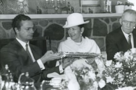
- Photograph of His Royal Highness King Carl XVI Gustaf of Sweden and Queen Silvia of Sweden enjoying a luncheon held at the Swedish Canadian Rest Home and Manor. Gunnar Axelson, president of the Swedish Canadian Rest Home, is seated on the other side of the Queen.
- Repository
- City of Burnaby Archives
- Date
- March 18, 1988
- Collection/Fonds
- Burnaby Historical Society fonds
- Subseries
- Gavel Historical Society subseries
- Physical Description
- 1 photograph : b&w ; 16 x 24.5 cm
- Description Level
- Item
- Record No.
- 311-007
- Access Restriction
- No restrictions
- Reproduction Restriction
- Reproduce for fair dealing purposes only
- Accession Number
- BHS1994-03
- Scope and Content
- Photograph of His Royal Highness King Carl XVI Gustaf of Sweden and Queen Silvia of Sweden enjoying a luncheon held at the Swedish Canadian Rest Home and Manor. Gunnar Axelson, president of the Swedish Canadian Rest Home, is seated on the other side of the Queen.
- Names
- Silvia, Queen, consort of Carl XVI Gustaf, King of Sweden, 1943-
- Carl XVI Gustaf King of Sweden, 1946-
- Swedish Canadian Rest Home and Manor
- Axelson, Gunnar
- Media Type
- Photograph
- Photographer
- Harrison, Jim
- Notes
- Title based on contents of photograph
- Geographic Access
- Duthie Avenue
- Street Address
- 1812 Duthie Avenue
- Historic Neighbourhood
- Lochdale (Historic Neighbourhood)
- Planning Study Area
- Sperling-Broadway Area
Images

King Carl XVI Gustaf and Queen Silvia with the Axelsons
https://search.heritageburnaby.ca/link/archivedescription54225
- Repository
- City of Burnaby Archives
- Date
- March 18, 1988
- Collection/Fonds
- Burnaby Historical Society fonds
- Description Level
- Item
- Physical Description
- 1 photograph : b&w ; 16 x 24.5 cm
- Scope and Content
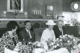
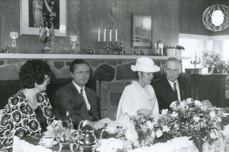
- Photograph of His Royal Highness King Carl XVI Gustaf of Sweden and Queen Silvia of Sweden seated in the center, enjoying a luncheon held at the Swedish Canadian Rest Home and Manor. Gunnar Axelson, president of the Swedish Canadian Rest Home, and his wife Mildred Axelson are seated on either side …
- Repository
- City of Burnaby Archives
- Date
- March 18, 1988
- Collection/Fonds
- Burnaby Historical Society fonds
- Subseries
- Gavel Historical Society subseries
- Physical Description
- 1 photograph : b&w ; 16 x 24.5 cm
- Description Level
- Item
- Record No.
- 311-008
- Access Restriction
- No restrictions
- Reproduction Restriction
- Reproduce for fair dealing purposes only
- Accession Number
- BHS1994-03
- Scope and Content
- Photograph of His Royal Highness King Carl XVI Gustaf of Sweden and Queen Silvia of Sweden seated in the center, enjoying a luncheon held at the Swedish Canadian Rest Home and Manor. Gunnar Axelson, president of the Swedish Canadian Rest Home, and his wife Mildred Axelson are seated on either side of the King and Queen.
- Names
- Silvia, Queen, consort of Carl XVI Gustaf, King of Sweden, 1943-
- Carl XVI Gustaf King of Sweden, 1946-
- Swedish Canadian Rest Home and Manor
- Axelson, Gunnar
- Axelson, Mildred
- Media Type
- Photograph
- Photographer
- Harrison, Jim
- Notes
- Title based on contents of photograph
- Geographic Access
- Duthie Avenue
- Street Address
- 1812 Duthie Avenue
- Historic Neighbourhood
- Lochdale (Historic Neighbourhood)
- Planning Study Area
- Sperling-Broadway Area
Images
![Kneale family home, [198-?] (date of original), copied 1992 thumbnail](/media/hpo/_Data/_Archives_Images/_Unrestricted/315/315-396.jpg?width=280)
Kneale family home
https://search.heritageburnaby.ca/link/archivedescription36938
- Repository
- City of Burnaby Archives
- Date
- [198-?] (date of original), copied 1992
- Collection/Fonds
- Burnaby Historical Society fonds
- Description Level
- Item
- Physical Description
- 1 photograph : b&w ; 8.1 x 12.2 cm print
- Scope and Content
- Photograph of the exterior of the Kneale family home at 6726 Broadway (at Sperling Avenue).
- Repository
- City of Burnaby Archives
- Date
- [198-?] (date of original), copied 1992
- Collection/Fonds
- Burnaby Historical Society fonds
- Subseries
- Burnaby Centennial Anthology subseries
- Physical Description
- 1 photograph : b&w ; 8.1 x 12.2 cm print
- Description Level
- Item
- Record No.
- 315-396
- Access Restriction
- No restrictions
- Reproduction Restriction
- Reproduce for fair dealing purposes only
- Accession Number
- BHS1994-04
- Scope and Content
- Photograph of the exterior of the Kneale family home at 6726 Broadway (at Sperling Avenue).
- Subjects
- Buildings - Residential - Houses
- Media Type
- Photograph
- Notes
- Title based on contents of photograph
- Geographic Access
- Broadway
- Street Address
- 6726 Broadway
- Historic Neighbourhood
- Lochdale (Historic Neighbourhood)
- Planning Study Area
- Sperling-Broadway Area
Images
![Kneale family home, [198-?] (date of original), copied 1992 thumbnail](/media/hpo/_Data/_Archives_Images/_Unrestricted/315/315-396.jpg)

Kensington Overpass Area
https://search.heritageburnaby.ca/link/archivedescription93631
- Repository
- City of Burnaby Archives
- Date
- October 22, 1977
- Collection/Fonds
- Burnaby Public Library Contemporary Visual Archive Project
- Description Level
- Item
- Physical Description
- 1 photograph : b&w ; 12.5 x 17.5 cm
- Scope and Content
- Photograph of the Kensington Overpass area by Lougheed Highway and Sperling Avenue. The overpass was not yet constructed at the time of this photograph but was under discussion by the City of Burnaby Council. The photograph is taken from the side of the road, facing south.
- Repository
- City of Burnaby Archives
- Date
- October 22, 1977
- Collection/Fonds
- Burnaby Public Library Contemporary Visual Archive Project
- Physical Description
- 1 photograph : b&w ; 12.5 x 17.5 cm
- Description Level
- Item
- Record No.
- 556-588
- Access Restriction
- No restrictions
- Reproduction Restriction
- Reproduce for fair dealing purposes only
- Accession Number
- 2017-57
- Scope and Content
- Photograph of the Kensington Overpass area by Lougheed Highway and Sperling Avenue. The overpass was not yet constructed at the time of this photograph but was under discussion by the City of Burnaby Council. The photograph is taken from the side of the road, facing south.
- Media Type
- Photograph
- Photographer
- Surridge, Jack
- Notes
- Title taken from project information form
- Accompanied by a project information form and 1 photograph (b&w negative ; 9.5 x 12.5 cm)
- BPL no. 37
- Geographic Access
- Kensington Avenue
- Sperling Avenue
- Lougheed Highway
- Planning Study Area
- Sperling-Broadway Area
Images


House at 2465 Sperling Avenue
https://search.heritageburnaby.ca/link/archivedescription78868
- Repository
- City of Burnaby Archives
- Date
- November 14, 1976
- Collection/Fonds
- Burnaby Public Library Contemporary Visual Archive Project
- Description Level
- Item
- Physical Description
- 1 photograph : b&w ; 11 x 16 cm mounted on cardboard
- Scope and Content
- Photograph shows an abandoned house at 2465 Sperling Aveue.
- Repository
- City of Burnaby Archives
- Date
- November 14, 1976
- Collection/Fonds
- Burnaby Public Library Contemporary Visual Archive Project
- Physical Description
- 1 photograph : b&w ; 11 x 16 cm mounted on cardboard
- Description Level
- Item
- Record No.
- 556-011
- Access Restriction
- No restrictions
- Reproduction Restriction
- Reproduce for fair dealing purposes only
- Accession Number
- 2013-13
- Scope and Content
- Photograph shows an abandoned house at 2465 Sperling Aveue.
- Media Type
- Photograph
- Photographer
- Norton, Paul
- Notes
- Scope note taken directly from BPL photograph description.
- 1 b&w copy negative : 10 x 12.5 cm accompanying
- Geographic Access
- Sperling Avenue
- Street Address
- 2465 Sperling Avenue
- Historic Neighbourhood
- Lochdale (Historic Neighbourhood)
- Planning Study Area
- Sperling-Broadway Area
Images


Veranda of house at 2465 Sperling Avenue
https://search.heritageburnaby.ca/link/archivedescription78870
- Repository
- City of Burnaby Archives
- Date
- November 14, 1976
- Collection/Fonds
- Burnaby Public Library Contemporary Visual Archive Project
- Description Level
- Item
- Physical Description
- 1 photograph : b&w ; 11 x 16 cm mounted on cardboard
- Scope and Content
- Photograph shows the veranda of an abandoned house at 2465 Sperling Aveue.
- Repository
- City of Burnaby Archives
- Date
- November 14, 1976
- Collection/Fonds
- Burnaby Public Library Contemporary Visual Archive Project
- Physical Description
- 1 photograph : b&w ; 11 x 16 cm mounted on cardboard
- Description Level
- Item
- Record No.
- 556-012
- Access Restriction
- No restrictions
- Reproduction Restriction
- Reproduce for fair dealing purposes only
- Accession Number
- 2013-13
- Scope and Content
- Photograph shows the veranda of an abandoned house at 2465 Sperling Aveue.
- Media Type
- Photograph
- Photographer
- Norton, Paul
- Notes
- Scope note taken directly from BPL photograph description.
- 1 b&w copy negative : 10 x 12.5 cm accompanying
- Geographic Access
- Sperling Avenue
- Street Address
- 2465 Sperling Avenue
- Historic Neighbourhood
- Lochdale (Historic Neighbourhood)
- Planning Study Area
- Sperling-Broadway Area
Images


House at 6670 Broadway
https://search.heritageburnaby.ca/link/archivedescription78901
- Repository
- City of Burnaby Archives
- Date
- September 22, 1976
- Collection/Fonds
- Burnaby Public Library Contemporary Visual Archive Project
- Description Level
- Item
- Physical Description
- 1 photograph : b&w ; 11 x 16 cm mounted on cardboard
- Scope and Content
- Photograph shows a log house located at 6670 Broadway near Sperling Avenue.
- Repository
- City of Burnaby Archives
- Date
- September 22, 1976
- Collection/Fonds
- Burnaby Public Library Contemporary Visual Archive Project
- Physical Description
- 1 photograph : b&w ; 11 x 16 cm mounted on cardboard
- Description Level
- Item
- Record No.
- 556-024
- Access Restriction
- No restrictions
- Reproduction Restriction
- Reproduce for fair dealing purposes only
- Accession Number
- 2013-13
- Scope and Content
- Photograph shows a log house located at 6670 Broadway near Sperling Avenue.
- Media Type
- Photograph
- Photographer
- McCarron, John
- Notes
- Scope note taken directly from BPL photograph description.
- 1 b&w copy negative : 10 x 12.5 cm accompanying
- Geographic Access
- Broadway
- Street Address
- 6670 Broadway
- Historic Neighbourhood
- Lochdale (Historic Neighbourhood)
- Planning Study Area
- Sperling-Broadway Area
Images


House at 7390 Montecito Drive
https://search.heritageburnaby.ca/link/archivedescription78930
- Repository
- City of Burnaby Archives
- Date
- November 19,1976
- Collection/Fonds
- Burnaby Public Library Contemporary Visual Archive Project
- Description Level
- Item
- Physical Description
- 1 photograph : b&w ; 11 x 16 cm mounted on cardboard
- Scope and Content
- Photograph shows a demon sculpture in front of house at 7390 Montecito Drive.
- Repository
- City of Burnaby Archives
- Date
- November 19,1976
- Collection/Fonds
- Burnaby Public Library Contemporary Visual Archive Project
- Physical Description
- 1 photograph : b&w ; 11 x 16 cm mounted on cardboard
- Description Level
- Item
- Record No.
- 556-038
- Access Restriction
- No restrictions
- Reproduction Restriction
- Reproduce for fair dealing purposes only
- Accession Number
- 2013-13
- Scope and Content
- Photograph shows a demon sculpture in front of house at 7390 Montecito Drive.
- Media Type
- Photograph
- Photographer
- Born, A. J.
- Notes
- Scope note taken directly from BPL photograph description.
- 1 b&w copy negative : 10 x 12.5 cm accompanying
- Geographic Access
- Montecito Drive
- Street Address
- 7390 Montecito Drive
- Historic Neighbourhood
- Burquitlam (Historic Neighbourhood)
- Planning Study Area
- Sperling-Broadway Area
Images


House at 7390 Montecito Drive
https://search.heritageburnaby.ca/link/archivedescription78932
- Repository
- City of Burnaby Archives
- Date
- November 19,1976
- Collection/Fonds
- Burnaby Public Library Contemporary Visual Archive Project
- Description Level
- Item
- Physical Description
- 1 photograph : b&w ; 11 x 16 cm mounted on cardboard
- Scope and Content
- Photograph shows a close up of the demon sculpture in front of house at 7390 Montecito Drive.
- Repository
- City of Burnaby Archives
- Date
- November 19,1976
- Collection/Fonds
- Burnaby Public Library Contemporary Visual Archive Project
- Physical Description
- 1 photograph : b&w ; 11 x 16 cm mounted on cardboard
- Description Level
- Item
- Record No.
- 556-039
- Access Restriction
- No restrictions
- Reproduction Restriction
- Reproduce for fair dealing purposes only
- Accession Number
- 2013-13
- Scope and Content
- Photograph shows a close up of the demon sculpture in front of house at 7390 Montecito Drive.
- Media Type
- Photograph
- Photographer
- Born, A. J.
- Notes
- Scope note taken directly from BPL photograph description.
- 1 b&w copy negative : 10 x 12.5 cm accompanying
- Geographic Access
- Montecito Drive
- Street Address
- 7390 Montecito Drive
- Historic Neighbourhood
- Burquitlam (Historic Neighbourhood)
- Planning Study Area
- Sperling-Broadway Area
Images


Ornamental fountain at 6657 East Broadway
https://search.heritageburnaby.ca/link/archivedescription78938
- Repository
- City of Burnaby Archives
- Date
- November 17,1976
- Collection/Fonds
- Burnaby Public Library Contemporary Visual Archive Project
- Description Level
- Item
- Physical Description
- 1 photograph : b&w ; 11 x 16 cm mounted on cardboard
- Scope and Content
- Photograph shows an ornamental fountain with various statues at 6657 East Broadway. The statues were supplied by Zanetti Arts.
- Repository
- City of Burnaby Archives
- Date
- November 17,1976
- Collection/Fonds
- Burnaby Public Library Contemporary Visual Archive Project
- Physical Description
- 1 photograph : b&w ; 11 x 16 cm mounted on cardboard
- Description Level
- Item
- Record No.
- 556-041
- Access Restriction
- No restrictions
- Reproduction Restriction
- Reproduce for fair dealing purposes only
- Accession Number
- 2013-13
- Scope and Content
- Photograph shows an ornamental fountain with various statues at 6657 East Broadway. The statues were supplied by Zanetti Arts.
- Names
- Zanetti Arts
- Media Type
- Photograph
- Photographer
- Born, A. J.
- Notes
- Scope note taken directly from BPL photograph description.
- 1 b&w copy negative : 10 x 12.5 cm accompanying
- Geographic Access
- Broadway
- Street Address
- 6657 Broadway
- Historic Neighbourhood
- Lochdale (Historic Neighbourhood)
- Planning Study Area
- Sperling-Broadway Area
Images


Home at 2291 Cliff Avenue
https://search.heritageburnaby.ca/link/archivedescription78948
- Repository
- City of Burnaby Archives
- Date
- October 4,1976
- Collection/Fonds
- Burnaby Public Library Contemporary Visual Archive Project
- Description Level
- Item
- Physical Description
- 1 photograph : b&w ; 11 x 16 cm mounted on cardboard
- Scope and Content
- Photograph shows the gate, with cherubs, outside the home at 2291 Cliff Avenue.
- Repository
- City of Burnaby Archives
- Date
- October 4,1976
- Collection/Fonds
- Burnaby Public Library Contemporary Visual Archive Project
- Physical Description
- 1 photograph : b&w ; 11 x 16 cm mounted on cardboard
- Description Level
- Item
- Record No.
- 556-043
- Access Restriction
- No restrictions
- Reproduction Restriction
- Reproduce for fair dealing purposes only
- Accession Number
- 2013-13
- Scope and Content
- Photograph shows the gate, with cherubs, outside the home at 2291 Cliff Avenue.
- Media Type
- Photograph
- Photographer
- Born, A. J.
- Notes
- Scope note taken directly from BPL photograph description.
- 1 b&w copy negative : 10 x 12.5 cm accompanying
- Geographic Access
- Cliff Avenue
- Street Address
- 2291 Cliff Avenue
- Historic Neighbourhood
- Lochdale (Historic Neighbourhood)
- Planning Study Area
- Sperling-Broadway Area
Images


House at 2971 Phillips Avenue
https://search.heritageburnaby.ca/link/archivedescription78959
- Repository
- City of Burnaby Archives
- Date
- September 22,1976
- Collection/Fonds
- Burnaby Public Library Contemporary Visual Archive Project
- Description Level
- Item
- Physical Description
- 1 photograph : b&w ; 11 x 16 cm mounted on cardboard
- Scope and Content
- Photograph shows a house at 2971 Phillips Avenue, near Lougheed Highway, constructed in approximately 1906.
- Repository
- City of Burnaby Archives
- Date
- September 22,1976
- Collection/Fonds
- Burnaby Public Library Contemporary Visual Archive Project
- Physical Description
- 1 photograph : b&w ; 11 x 16 cm mounted on cardboard
- Description Level
- Item
- Record No.
- 556-052
- Access Restriction
- No restrictions
- Reproduction Restriction
- Reproduce for fair dealing purposes only
- Accession Number
- 2013-13
- Scope and Content
- Photograph shows a house at 2971 Phillips Avenue, near Lougheed Highway, constructed in approximately 1906.
- Media Type
- Photograph
- Photographer
- McCarron, John
- Notes
- Scope note taken directly from BPL photograph description.
- 1 b&w copy negative : 10 x 12.5 cm accompanying
- Geographic Access
- Phillips Avenue
- Street Address
- 2971 Phillips Avenue
- Historic Neighbourhood
- Lochdale (Historic Neighbourhood)
- Planning Study Area
- Sperling-Broadway Area
Images


House at 2910 Camrose Avenue
https://search.heritageburnaby.ca/link/archivedescription78967
- Repository
- City of Burnaby Archives
- Date
- September 22,1976
- Collection/Fonds
- Burnaby Public Library Contemporary Visual Archive Project
- Description Level
- Item
- Physical Description
- 1 photograph : b&w ; 11 x 16 cm mounted on cardboard
- Scope and Content
- Photograph shows a house at 2910 Camrose Avenue constructed approximately 1906 on a log foundation. The house was built in three sections.
- Repository
- City of Burnaby Archives
- Date
- September 22,1976
- Collection/Fonds
- Burnaby Public Library Contemporary Visual Archive Project
- Physical Description
- 1 photograph : b&w ; 11 x 16 cm mounted on cardboard
- Description Level
- Item
- Record No.
- 556-056
- Access Restriction
- No restrictions
- Reproduction Restriction
- Reproduce for fair dealing purposes only
- Accession Number
- 2013-13
- Scope and Content
- Photograph shows a house at 2910 Camrose Avenue constructed approximately 1906 on a log foundation. The house was built in three sections.
- Media Type
- Photograph
- Photographer
- McCarron, John
- Notes
- Scope note taken directly from BPL photograph description.
- 1 b&w copy negative : 10 x 12.5 cm accompanying
- Geographic Access
- Camrose Drive
- Street Address
- 2910 Camrose Drive
- Historic Neighbourhood
- Lochdale (Historic Neighbourhood)
- Planning Study Area
- Sperling-Broadway Area
Images


Shack at 7400 Block Halifax Street
https://search.heritageburnaby.ca/link/archivedescription78993
- Repository
- City of Burnaby Archives
- Date
- September 7, 1976
- Collection/Fonds
- Burnaby Public Library Contemporary Visual Archive Project
- Description Level
- Item
- Physical Description
- 1 photograph : b&w ; 11 x 16 cm mounted on cardboard
- Scope and Content
- Photograph shows an old shack in the 7400 Block Halifax Street built in approximately 1930. The shack was a boiler shed for what was then a 40-acre farm specializing in pigs and horses.
- Repository
- City of Burnaby Archives
- Date
- September 7, 1976
- Collection/Fonds
- Burnaby Public Library Contemporary Visual Archive Project
- Physical Description
- 1 photograph : b&w ; 11 x 16 cm mounted on cardboard
- Description Level
- Item
- Record No.
- 556-078
- Access Restriction
- No restrictions
- Reproduction Restriction
- Reproduce for fair dealing purposes only
- Accession Number
- 2013-13
- Scope and Content
- Photograph shows an old shack in the 7400 Block Halifax Street built in approximately 1930. The shack was a boiler shed for what was then a 40-acre farm specializing in pigs and horses.
- Subjects
- Agriculture - Farms
- Media Type
- Photograph
- Photographer
- Born, A. J.
- Notes
- Scope note taken directly from BPL photograph description.
- 1 b&w copy negative : 10 x 12.5 cm accompanying
- Geographic Access
- Halifax Street
- Historic Neighbourhood
- Lochdale (Historic Neighbourhood)
- Planning Study Area
- Sperling-Broadway Area
Images


New Home on Phillips Avenue
https://search.heritageburnaby.ca/link/archivedescription78999
- Repository
- City of Burnaby Archives
- Date
- September 22, 1976
- Collection/Fonds
- Burnaby Public Library Contemporary Visual Archive Project
- Description Level
- Item
- Physical Description
- 1 photograph : b&w ; 11 x 16 cm mounted on cardboard
- Scope and Content
- Photograph shows a new, unoccupied home, on Phillips Avenue near the Lougheed Highway.
- Repository
- City of Burnaby Archives
- Date
- September 22, 1976
- Collection/Fonds
- Burnaby Public Library Contemporary Visual Archive Project
- Physical Description
- 1 photograph : b&w ; 11 x 16 cm mounted on cardboard
- Description Level
- Item
- Record No.
- 556-082
- Access Restriction
- No restrictions
- Reproduction Restriction
- Reproduce for fair dealing purposes only
- Accession Number
- 2013-13
- Scope and Content
- Photograph shows a new, unoccupied home, on Phillips Avenue near the Lougheed Highway.
- Subjects
- Construction
- Media Type
- Photograph
- Photographer
- McCarron, John
- Notes
- Scope note taken directly from BPL photograph description.
- 1 b&w copy negative : 10 x 12.5 cm accompanying
- Geographic Access
- Phillips Avenue
- Street Address
- 3120 Phillips Avenue
- Historic Neighbourhood
- Lochdale (Historic Neighbourhood)
- Planning Study Area
- Sperling-Broadway Area
Images

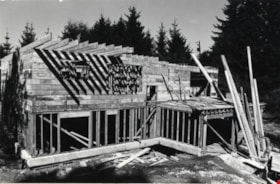
House construction on Paulus Crescent
https://search.heritageburnaby.ca/link/archivedescription79006
- Repository
- City of Burnaby Archives
- Date
- September 7, 1976
- Collection/Fonds
- Burnaby Public Library Contemporary Visual Archive Project
- Description Level
- Item
- Physical Description
- 1 photograph : b&w ; 11 x 16 cm mounted on cardboard
- Scope and Content
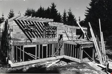
- Photograph shows house under construction on Paulus Crescent.
- Repository
- City of Burnaby Archives
- Date
- September 7, 1976
- Collection/Fonds
- Burnaby Public Library Contemporary Visual Archive Project
- Physical Description
- 1 photograph : b&w ; 11 x 16 cm mounted on cardboard
- Description Level
- Item
- Record No.
- 556-086
- Access Restriction
- No restrictions
- Reproduction Restriction
- Reproduce for fair dealing purposes only
- Accession Number
- 2013-13
- Scope and Content
- Photograph shows house under construction on Paulus Crescent.
- Subjects
- Construction
- Media Type
- Photograph
- Photographer
- Born, A. J.
- Notes
- Scope note taken directly from BPL photograph description.
- 1 b&w copy negative : 10 x 12.5 cm accompanying
- Geographic Access
- Paulus Crescent
- Historic Neighbourhood
- Lochdale (Historic Neighbourhood)
- Planning Study Area
- Sperling-Broadway Area
Images