Narrow Results By
Subject
- Advertising Medium - Signs and Signboards 1
- Aerial Photographs 1
- Agriculture - Farms 1
- Buildings - Civic - Fire Halls 1
- Buildings - Residential - Apartments 1
- Buildings - Residential - Houses 2
- Buildings - Residential - Seniors Housing 2
- Celebrations - Centennials 11
- Construction 2
- Education 1
- Events - Royal Visits 2
- Geographic Features - Roads 1
Person / Organization
- Axelson, Gunnar 2
- Axelson, Mildred 1
- Bossort, Kathy 1
- British Columbia Hydro and Power Authority 1
- Burnaby Mountain Golf Course 13
- Carl XVI Gustaf King of Sweden, 1946- 2
- Evenden, Leonard J. 1
- Seager, Allen 1
- Silvia, Queen, consort of Carl XVI Gustaf, King of Sweden, 1943- 2
- Simon Fraser University 1
- Skene, Gordon 2
- Swedish Canadian Rest Home and Manor 2
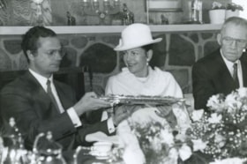
King Carl XVI Gustaf and Queen Silvia
https://search.heritageburnaby.ca/link/archivedescription36625
- Repository
- City of Burnaby Archives
- Date
- March 18, 1988
- Collection/Fonds
- Burnaby Historical Society fonds
- Description Level
- Item
- Physical Description
- 1 photograph : b&w ; 16 x 24.5 cm
- Scope and Content
- Photograph of His Royal Highness King Carl XVI Gustaf of Sweden and Queen Silvia of Sweden enjoying a luncheon held at the Swedish Canadian Rest Home and Manor. Gunnar Axelson, president of the Swedish Canadian Rest Home, is seated on the other side of the Queen.
- Repository
- City of Burnaby Archives
- Date
- March 18, 1988
- Collection/Fonds
- Burnaby Historical Society fonds
- Subseries
- Gavel Historical Society subseries
- Physical Description
- 1 photograph : b&w ; 16 x 24.5 cm
- Description Level
- Item
- Record No.
- 311-007
- Access Restriction
- No restrictions
- Reproduction Restriction
- Reproduce for fair dealing purposes only
- Accession Number
- BHS1994-03
- Scope and Content
- Photograph of His Royal Highness King Carl XVI Gustaf of Sweden and Queen Silvia of Sweden enjoying a luncheon held at the Swedish Canadian Rest Home and Manor. Gunnar Axelson, president of the Swedish Canadian Rest Home, is seated on the other side of the Queen.
- Names
- Silvia, Queen, consort of Carl XVI Gustaf, King of Sweden, 1943-
- Carl XVI Gustaf King of Sweden, 1946-
- Swedish Canadian Rest Home and Manor
- Axelson, Gunnar
- Media Type
- Photograph
- Photographer
- Harrison, Jim
- Notes
- Title based on contents of photograph
- Geographic Access
- Duthie Avenue
- Street Address
- 1812 Duthie Avenue
- Historic Neighbourhood
- Lochdale (Historic Neighbourhood)
- Planning Study Area
- Sperling-Broadway Area
Images

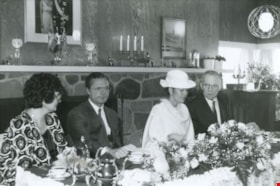
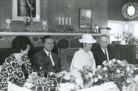
King Carl XVI Gustaf and Queen Silvia with the Axelsons
https://search.heritageburnaby.ca/link/archivedescription54225
- Repository
- City of Burnaby Archives
- Date
- March 18, 1988
- Collection/Fonds
- Burnaby Historical Society fonds
- Description Level
- Item
- Physical Description
- 1 photograph : b&w ; 16 x 24.5 cm
- Scope and Content
- Photograph of His Royal Highness King Carl XVI Gustaf of Sweden and Queen Silvia of Sweden seated in the center, enjoying a luncheon held at the Swedish Canadian Rest Home and Manor. Gunnar Axelson, president of the Swedish Canadian Rest Home, and his wife Mildred Axelson are seated on either side …
- Repository
- City of Burnaby Archives
- Date
- March 18, 1988
- Collection/Fonds
- Burnaby Historical Society fonds
- Subseries
- Gavel Historical Society subseries
- Physical Description
- 1 photograph : b&w ; 16 x 24.5 cm
- Description Level
- Item
- Record No.
- 311-008
- Access Restriction
- No restrictions
- Reproduction Restriction
- Reproduce for fair dealing purposes only
- Accession Number
- BHS1994-03
- Scope and Content
- Photograph of His Royal Highness King Carl XVI Gustaf of Sweden and Queen Silvia of Sweden seated in the center, enjoying a luncheon held at the Swedish Canadian Rest Home and Manor. Gunnar Axelson, president of the Swedish Canadian Rest Home, and his wife Mildred Axelson are seated on either side of the King and Queen.
- Names
- Silvia, Queen, consort of Carl XVI Gustaf, King of Sweden, 1943-
- Carl XVI Gustaf King of Sweden, 1946-
- Swedish Canadian Rest Home and Manor
- Axelson, Gunnar
- Axelson, Mildred
- Media Type
- Photograph
- Photographer
- Harrison, Jim
- Notes
- Title based on contents of photograph
- Geographic Access
- Duthie Avenue
- Street Address
- 1812 Duthie Avenue
- Historic Neighbourhood
- Lochdale (Historic Neighbourhood)
- Planning Study Area
- Sperling-Broadway Area
Images
![Wally Westerman shovelling snow in front of his house, [198-] thumbnail](/media/hpo/_Data/_BVM_Images/2020/2020_0017_0019_001.jpg?width=280)
Wally Westerman shovelling snow in front of his house
https://search.heritageburnaby.ca/link/museumdescription13695
- Repository
- Burnaby Village Museum
- Date
- [198-]
- Collection/Fonds
- Westerman family fonds
- Description Level
- Item
- Physical Description
- 1 photograph : col. ; 10 x 15 cm
- Scope and Content
- Photograph of Walter "Wally" Westerman shovelling snow in front of his house at 2171 Duthie Avenue in Burnaby.
- Repository
- Burnaby Village Museum
- Collection/Fonds
- Westerman family fonds
- Description Level
- Item
- Physical Description
- 1 photograph : col. ; 10 x 15 cm
- Material Details
- `
- Scope and Content
- Photograph of Walter "Wally" Westerman shovelling snow in front of his house at 2171 Duthie Avenue in Burnaby.
- Geographic Access
- Duthie Avenue
- Street Address
- 2171 Duthie Avenue
- Accession Code
- BV020.17.19
- Access Restriction
- No restrictions
- Reproduction Restriction
- No known restrictions
- Date
- [198-]
- Media Type
- Photograph
- Planning Study Area
- Sperling-Broadway Area
- Scan Resolution
- 600
- Scan Date
- 22-Sep-2020
- Scale
- 100
- Notes
- Title based on contents of photograph
- Handwritten note in pencil on verso of photograph reads: "Walter aged 11/ May 21st 1928"
Images
![Wally Westerman shovelling snow in front of his house, [198-] thumbnail](/media/hpo/_Data/_BVM_Images/2020/2020_0017_0019_001.jpg)
![Eagle Creek treehouse, [between 1980 and 2001] thumbnail](/media/hpo/_Data/_Archives_Images/_Unrestricted/600/618-022-1.jpg?width=280)
Eagle Creek treehouse
https://search.heritageburnaby.ca/link/archivedescription91704
- Repository
- City of Burnaby Archives
- Date
- [between 1980 and 2001]
- Collection/Fonds
- Doreen Lawson fonds
- Description Level
- File
- Physical Description
- 5 photographs : col. ; 15 cm x 10 cm
- Scope and Content
- File consists of photographs of a rustic two-storey treehouse located in the forest at Eagle Creek. The treehouse is triangular in shape and constructed around three evergreen trees. The file also contains one photograph of a broken tree stump.
- Repository
- City of Burnaby Archives
- Date
- [between 1980 and 2001]
- Collection/Fonds
- Doreen Lawson fonds
- Physical Description
- 5 photographs : col. ; 15 cm x 10 cm
- Description Level
- File
- Record No.
- 618-022
- Access Restriction
- No restrictions
- Reproduction Restriction
- No restrictions
- Accession Number
- 2015-15
- Scope and Content
- File consists of photographs of a rustic two-storey treehouse located in the forest at Eagle Creek. The treehouse is triangular in shape and constructed around three evergreen trees. The file also contains one photograph of a broken tree stump.
- Subjects
- Plants - Trees
- Media Type
- Photograph
- Photographer
- Lawson, Doreen A.
- Notes
- Title based on contents of photographs
- Note in black in on verso of photographs 618-022-1 : 618-022-4 reads: "Bby. Mtn. Parkway [at] Curtis / Eagle Creek, Upper Reaches / East Fork"
- Note in black in on verso of photograph 618-022-5 reads: "Bby. Mtn. Parkway / Eagle Creek, Upper Reaches"
- Geographic Access
- Eagle Creek
- Planning Study Area
- Sperling-Broadway Area
Images
![Eagle Creek treehouse, [between 1980 and 2001] thumbnail](/media/hpo/_Data/_Archives_Images/_Unrestricted/600/618-022-1.jpg)
![Kneale family home, [198-?] (date of original), copied 1992 thumbnail](/media/hpo/_Data/_Archives_Images/_Unrestricted/315/315-396.jpg?width=280)
Kneale family home
https://search.heritageburnaby.ca/link/archivedescription36938
- Repository
- City of Burnaby Archives
- Date
- [198-?] (date of original), copied 1992
- Collection/Fonds
- Burnaby Historical Society fonds
- Description Level
- Item
- Physical Description
- 1 photograph : b&w ; 8.1 x 12.2 cm print
- Scope and Content
- Photograph of the exterior of the Kneale family home at 6726 Broadway (at Sperling Avenue).
- Repository
- City of Burnaby Archives
- Date
- [198-?] (date of original), copied 1992
- Collection/Fonds
- Burnaby Historical Society fonds
- Subseries
- Burnaby Centennial Anthology subseries
- Physical Description
- 1 photograph : b&w ; 8.1 x 12.2 cm print
- Description Level
- Item
- Record No.
- 315-396
- Access Restriction
- No restrictions
- Reproduction Restriction
- Reproduce for fair dealing purposes only
- Accession Number
- BHS1994-04
- Scope and Content
- Photograph of the exterior of the Kneale family home at 6726 Broadway (at Sperling Avenue).
- Subjects
- Buildings - Residential - Houses
- Media Type
- Photograph
- Notes
- Title based on contents of photograph
- Geographic Access
- Broadway
- Street Address
- 6726 Broadway
- Historic Neighbourhood
- Lochdale (Historic Neighbourhood)
- Planning Study Area
- Sperling-Broadway Area
Images
![Kneale family home, [198-?] (date of original), copied 1992 thumbnail](/media/hpo/_Data/_Archives_Images/_Unrestricted/315/315-396.jpg)

Kensington Overpass Area
https://search.heritageburnaby.ca/link/archivedescription93631
- Repository
- City of Burnaby Archives
- Date
- October 22, 1977
- Collection/Fonds
- Burnaby Public Library Contemporary Visual Archive Project
- Description Level
- Item
- Physical Description
- 1 photograph : b&w ; 12.5 x 17.5 cm
- Scope and Content
- Photograph of the Kensington Overpass area by Lougheed Highway and Sperling Avenue. The overpass was not yet constructed at the time of this photograph but was under discussion by the City of Burnaby Council. The photograph is taken from the side of the road, facing south.
- Repository
- City of Burnaby Archives
- Date
- October 22, 1977
- Collection/Fonds
- Burnaby Public Library Contemporary Visual Archive Project
- Physical Description
- 1 photograph : b&w ; 12.5 x 17.5 cm
- Description Level
- Item
- Record No.
- 556-588
- Access Restriction
- No restrictions
- Reproduction Restriction
- Reproduce for fair dealing purposes only
- Accession Number
- 2017-57
- Scope and Content
- Photograph of the Kensington Overpass area by Lougheed Highway and Sperling Avenue. The overpass was not yet constructed at the time of this photograph but was under discussion by the City of Burnaby Council. The photograph is taken from the side of the road, facing south.
- Media Type
- Photograph
- Photographer
- Surridge, Jack
- Notes
- Title taken from project information form
- Accompanied by a project information form and 1 photograph (b&w negative ; 9.5 x 12.5 cm)
- BPL no. 37
- Geographic Access
- Kensington Avenue
- Sperling Avenue
- Lougheed Highway
- Planning Study Area
- Sperling-Broadway Area
Images

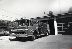
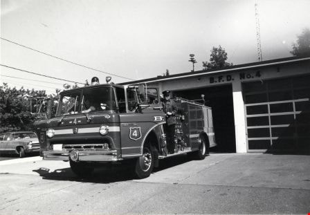
Fire Hall No. 4
https://search.heritageburnaby.ca/link/archivedescription79600
- Repository
- City of Burnaby Archives
- Date
- September 7, 1976
- Collection/Fonds
- Burnaby Public Library Contemporary Visual Archive Project
- Description Level
- Item
- Physical Description
- 1 photograph : b&w ; 11 x 16 cm mounted on cardboard
- Scope and Content
- Photograph shows fire engine at Burnaby Fire Hall No. 4, on the corner of Duthie Avenue and Montecito Drive. Just as the photographer was taking this picture, the bell rang and the firemen jumped into the truck, ready to go to a fire on Pandora Street.
- Repository
- City of Burnaby Archives
- Date
- September 7, 1976
- Collection/Fonds
- Burnaby Public Library Contemporary Visual Archive Project
- Physical Description
- 1 photograph : b&w ; 11 x 16 cm mounted on cardboard
- Description Level
- Item
- Record No.
- 556-345
- Access Restriction
- No restrictions
- Reproduction Restriction
- Reproduce for fair dealing purposes only
- Accession Number
- 2013-13
- Scope and Content
- Photograph shows fire engine at Burnaby Fire Hall No. 4, on the corner of Duthie Avenue and Montecito Drive. Just as the photographer was taking this picture, the bell rang and the firemen jumped into the truck, ready to go to a fire on Pandora Street.
- Media Type
- Photograph
- Photographer
- Born, A. J.
- Notes
- Scope note taken directly from BPL photograph description.
- 1 b&w copy negative : 10 x 12.5 cm accompanying
- Geographic Access
- Duthie Avenue
- Street Address
- 2326 Duthie Avenue
- Planning Study Area
- Sperling-Broadway Area
Images
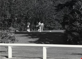
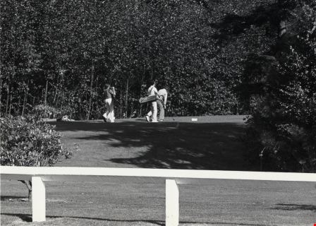
Burnaby Mountain Golf Course
https://search.heritageburnaby.ca/link/archivedescription79685
- Repository
- City of Burnaby Archives
- Date
- October, 1976
- Collection/Fonds
- Burnaby Public Library Contemporary Visual Archive Project
- Description Level
- Item
- Physical Description
- 1 photograph : b&w ; 11 x 16 cm mounted on cardboard
- Scope and Content
- Photograph shows golfers at Burnaby Mountain Golf Course, 7600 Halifax Street. Construction of the course began in September 1965; it opened to the public in May 1969. The course is 18 holes, 5418 yards long and covers 137 acres.
- Repository
- City of Burnaby Archives
- Date
- October, 1976
- Collection/Fonds
- Burnaby Public Library Contemporary Visual Archive Project
- Physical Description
- 1 photograph : b&w ; 11 x 16 cm mounted on cardboard
- Description Level
- Item
- Record No.
- 556-381
- Access Restriction
- No restrictions
- Reproduction Restriction
- Reproduce for fair dealing purposes only
- Accession Number
- 2013-13
- Scope and Content
- Photograph shows golfers at Burnaby Mountain Golf Course, 7600 Halifax Street. Construction of the course began in September 1965; it opened to the public in May 1969. The course is 18 holes, 5418 yards long and covers 137 acres.
- Subjects
- Recreational Activities - Golf
- Media Type
- Photograph
- Photographer
- Salmon, Stu
- Notes
- Scope note taken directly from BPL photograph description.
- Accompanying Burnaby Parks and Recreation Commission - Burnaby Mountain Golf Course informational document attached to verso.
- 1 b&w copy negative : 10 x 12.5 cm accompanying
- Geographic Access
- Halifax Street
- Street Address
- 7600 Halifax Street
- Planning Study Area
- Sperling-Broadway Area
Images

Garage Sale Sign
https://search.heritageburnaby.ca/link/archivedescription79926
- Repository
- City of Burnaby Archives
- Date
- September 7, 1976
- Collection/Fonds
- Burnaby Public Library Contemporary Visual Archive Project
- Description Level
- Item
- Physical Description
- 1 photograph : b&w ; 11 x 16 cm mounted on cardboard
- Scope and Content
- Photograph shows signs advertising a garage sale at 6889 Adair Street. The owners held the sale prior to moving from Burnaby into Vancouver.
- Repository
- City of Burnaby Archives
- Date
- September 7, 1976
- Collection/Fonds
- Burnaby Public Library Contemporary Visual Archive Project
- Physical Description
- 1 photograph : b&w ; 11 x 16 cm mounted on cardboard
- Description Level
- Item
- Record No.
- 556-497
- Access Restriction
- No restrictions
- Reproduction Restriction
- Reproduce for fair dealing purposes only
- Accession Number
- 2013-13
- Scope and Content
- Photograph shows signs advertising a garage sale at 6889 Adair Street. The owners held the sale prior to moving from Burnaby into Vancouver.
- Media Type
- Photograph
- Photographer
- Born, A. J.
- Notes
- Scope note taken directly from BPL photograph description.
- 1 b&w copy negative : 10 x 12.5 cm accompanying
- Geographic Access
- Adair Street
- Street Address
- 6889 Adair Street
- Historic Neighbourhood
- Lochdale (Historic Neighbourhood)
- Planning Study Area
- Sperling-Broadway Area
Images


Sperling Avenue Looking South
https://search.heritageburnaby.ca/link/archivedescription79948
- Repository
- City of Burnaby Archives
- Date
- September 20, 1976
- Collection/Fonds
- Burnaby Public Library Contemporary Visual Archive Project
- Description Level
- Item
- Physical Description
- 1 photograph : b&w ; 11 x 16 cm mounted on cardboard
- Scope and Content
- Photograph shows a view of Sperling Avenue looking south from Broadway.
- Repository
- City of Burnaby Archives
- Date
- September 20, 1976
- Collection/Fonds
- Burnaby Public Library Contemporary Visual Archive Project
- Physical Description
- 1 photograph : b&w ; 11 x 16 cm mounted on cardboard
- Description Level
- Item
- Record No.
- 556-519
- Access Restriction
- No restrictions
- Reproduction Restriction
- Reproduce for fair dealing purposes only
- Accession Number
- 2013-13
- Scope and Content
- Photograph shows a view of Sperling Avenue looking south from Broadway.
- Subjects
- Aerial Photographs
- Media Type
- Photograph
- Photographer
- McCarron, John
- Notes
- Scope note taken directly from BPL photograph description.
- 1 b&w copy negative : 10 x 12.5 cm accompanying
- Geographic Access
- Sperling Avenue
- Historic Neighbourhood
- Lochdale (Historic Neighbourhood)
- Planning Study Area
- Sperling-Broadway Area
Images


Camrose Drive
https://search.heritageburnaby.ca/link/archivedescription79961
- Repository
- City of Burnaby Archives
- Date
- September 22, 1976
- Collection/Fonds
- Burnaby Public Library Contemporary Visual Archive Project
- Description Level
- Item
- Physical Description
- 1 photograph : b&w ; 11 x 16 cm mounted on cardboard
- Scope and Content
- Photograph shows a view down Camrose Drive, looking south.
- Repository
- City of Burnaby Archives
- Date
- September 22, 1976
- Collection/Fonds
- Burnaby Public Library Contemporary Visual Archive Project
- Physical Description
- 1 photograph : b&w ; 11 x 16 cm mounted on cardboard
- Description Level
- Item
- Record No.
- 556-524
- Access Restriction
- No restrictions
- Reproduction Restriction
- Reproduce for fair dealing purposes only
- Accession Number
- 2013-13
- Scope and Content
- Photograph shows a view down Camrose Drive, looking south.
- Media Type
- Photograph
- Photographer
- McCarron, John
- Notes
- Scope note taken directly from BPL photograph description.
- 1 b&w copy negative : 10 x 12.5 cm accompanying
- Geographic Access
- Camrose Drive
- Planning Study Area
- Sperling-Broadway Area
Images


House at 2465 Sperling Avenue
https://search.heritageburnaby.ca/link/archivedescription78868
- Repository
- City of Burnaby Archives
- Date
- November 14, 1976
- Collection/Fonds
- Burnaby Public Library Contemporary Visual Archive Project
- Description Level
- Item
- Physical Description
- 1 photograph : b&w ; 11 x 16 cm mounted on cardboard
- Scope and Content
- Photograph shows an abandoned house at 2465 Sperling Aveue.
- Repository
- City of Burnaby Archives
- Date
- November 14, 1976
- Collection/Fonds
- Burnaby Public Library Contemporary Visual Archive Project
- Physical Description
- 1 photograph : b&w ; 11 x 16 cm mounted on cardboard
- Description Level
- Item
- Record No.
- 556-011
- Access Restriction
- No restrictions
- Reproduction Restriction
- Reproduce for fair dealing purposes only
- Accession Number
- 2013-13
- Scope and Content
- Photograph shows an abandoned house at 2465 Sperling Aveue.
- Media Type
- Photograph
- Photographer
- Norton, Paul
- Notes
- Scope note taken directly from BPL photograph description.
- 1 b&w copy negative : 10 x 12.5 cm accompanying
- Geographic Access
- Sperling Avenue
- Street Address
- 2465 Sperling Avenue
- Historic Neighbourhood
- Lochdale (Historic Neighbourhood)
- Planning Study Area
- Sperling-Broadway Area
Images


Veranda of house at 2465 Sperling Avenue
https://search.heritageburnaby.ca/link/archivedescription78870
- Repository
- City of Burnaby Archives
- Date
- November 14, 1976
- Collection/Fonds
- Burnaby Public Library Contemporary Visual Archive Project
- Description Level
- Item
- Physical Description
- 1 photograph : b&w ; 11 x 16 cm mounted on cardboard
- Scope and Content
- Photograph shows the veranda of an abandoned house at 2465 Sperling Aveue.
- Repository
- City of Burnaby Archives
- Date
- November 14, 1976
- Collection/Fonds
- Burnaby Public Library Contemporary Visual Archive Project
- Physical Description
- 1 photograph : b&w ; 11 x 16 cm mounted on cardboard
- Description Level
- Item
- Record No.
- 556-012
- Access Restriction
- No restrictions
- Reproduction Restriction
- Reproduce for fair dealing purposes only
- Accession Number
- 2013-13
- Scope and Content
- Photograph shows the veranda of an abandoned house at 2465 Sperling Aveue.
- Media Type
- Photograph
- Photographer
- Norton, Paul
- Notes
- Scope note taken directly from BPL photograph description.
- 1 b&w copy negative : 10 x 12.5 cm accompanying
- Geographic Access
- Sperling Avenue
- Street Address
- 2465 Sperling Avenue
- Historic Neighbourhood
- Lochdale (Historic Neighbourhood)
- Planning Study Area
- Sperling-Broadway Area
Images


House at 6670 Broadway
https://search.heritageburnaby.ca/link/archivedescription78901
- Repository
- City of Burnaby Archives
- Date
- September 22, 1976
- Collection/Fonds
- Burnaby Public Library Contemporary Visual Archive Project
- Description Level
- Item
- Physical Description
- 1 photograph : b&w ; 11 x 16 cm mounted on cardboard
- Scope and Content
- Photograph shows a log house located at 6670 Broadway near Sperling Avenue.
- Repository
- City of Burnaby Archives
- Date
- September 22, 1976
- Collection/Fonds
- Burnaby Public Library Contemporary Visual Archive Project
- Physical Description
- 1 photograph : b&w ; 11 x 16 cm mounted on cardboard
- Description Level
- Item
- Record No.
- 556-024
- Access Restriction
- No restrictions
- Reproduction Restriction
- Reproduce for fair dealing purposes only
- Accession Number
- 2013-13
- Scope and Content
- Photograph shows a log house located at 6670 Broadway near Sperling Avenue.
- Media Type
- Photograph
- Photographer
- McCarron, John
- Notes
- Scope note taken directly from BPL photograph description.
- 1 b&w copy negative : 10 x 12.5 cm accompanying
- Geographic Access
- Broadway
- Street Address
- 6670 Broadway
- Historic Neighbourhood
- Lochdale (Historic Neighbourhood)
- Planning Study Area
- Sperling-Broadway Area
Images


House at 7390 Montecito Drive
https://search.heritageburnaby.ca/link/archivedescription78930
- Repository
- City of Burnaby Archives
- Date
- November 19,1976
- Collection/Fonds
- Burnaby Public Library Contemporary Visual Archive Project
- Description Level
- Item
- Physical Description
- 1 photograph : b&w ; 11 x 16 cm mounted on cardboard
- Scope and Content
- Photograph shows a demon sculpture in front of house at 7390 Montecito Drive.
- Repository
- City of Burnaby Archives
- Date
- November 19,1976
- Collection/Fonds
- Burnaby Public Library Contemporary Visual Archive Project
- Physical Description
- 1 photograph : b&w ; 11 x 16 cm mounted on cardboard
- Description Level
- Item
- Record No.
- 556-038
- Access Restriction
- No restrictions
- Reproduction Restriction
- Reproduce for fair dealing purposes only
- Accession Number
- 2013-13
- Scope and Content
- Photograph shows a demon sculpture in front of house at 7390 Montecito Drive.
- Media Type
- Photograph
- Photographer
- Born, A. J.
- Notes
- Scope note taken directly from BPL photograph description.
- 1 b&w copy negative : 10 x 12.5 cm accompanying
- Geographic Access
- Montecito Drive
- Street Address
- 7390 Montecito Drive
- Historic Neighbourhood
- Burquitlam (Historic Neighbourhood)
- Planning Study Area
- Sperling-Broadway Area
Images


House at 7390 Montecito Drive
https://search.heritageburnaby.ca/link/archivedescription78932
- Repository
- City of Burnaby Archives
- Date
- November 19,1976
- Collection/Fonds
- Burnaby Public Library Contemporary Visual Archive Project
- Description Level
- Item
- Physical Description
- 1 photograph : b&w ; 11 x 16 cm mounted on cardboard
- Scope and Content
- Photograph shows a close up of the demon sculpture in front of house at 7390 Montecito Drive.
- Repository
- City of Burnaby Archives
- Date
- November 19,1976
- Collection/Fonds
- Burnaby Public Library Contemporary Visual Archive Project
- Physical Description
- 1 photograph : b&w ; 11 x 16 cm mounted on cardboard
- Description Level
- Item
- Record No.
- 556-039
- Access Restriction
- No restrictions
- Reproduction Restriction
- Reproduce for fair dealing purposes only
- Accession Number
- 2013-13
- Scope and Content
- Photograph shows a close up of the demon sculpture in front of house at 7390 Montecito Drive.
- Media Type
- Photograph
- Photographer
- Born, A. J.
- Notes
- Scope note taken directly from BPL photograph description.
- 1 b&w copy negative : 10 x 12.5 cm accompanying
- Geographic Access
- Montecito Drive
- Street Address
- 7390 Montecito Drive
- Historic Neighbourhood
- Burquitlam (Historic Neighbourhood)
- Planning Study Area
- Sperling-Broadway Area
Images


Ornamental fountain at 6657 East Broadway
https://search.heritageburnaby.ca/link/archivedescription78938
- Repository
- City of Burnaby Archives
- Date
- November 17,1976
- Collection/Fonds
- Burnaby Public Library Contemporary Visual Archive Project
- Description Level
- Item
- Physical Description
- 1 photograph : b&w ; 11 x 16 cm mounted on cardboard
- Scope and Content
- Photograph shows an ornamental fountain with various statues at 6657 East Broadway. The statues were supplied by Zanetti Arts.
- Repository
- City of Burnaby Archives
- Date
- November 17,1976
- Collection/Fonds
- Burnaby Public Library Contemporary Visual Archive Project
- Physical Description
- 1 photograph : b&w ; 11 x 16 cm mounted on cardboard
- Description Level
- Item
- Record No.
- 556-041
- Access Restriction
- No restrictions
- Reproduction Restriction
- Reproduce for fair dealing purposes only
- Accession Number
- 2013-13
- Scope and Content
- Photograph shows an ornamental fountain with various statues at 6657 East Broadway. The statues were supplied by Zanetti Arts.
- Names
- Zanetti Arts
- Media Type
- Photograph
- Photographer
- Born, A. J.
- Notes
- Scope note taken directly from BPL photograph description.
- 1 b&w copy negative : 10 x 12.5 cm accompanying
- Geographic Access
- Broadway
- Street Address
- 6657 Broadway
- Historic Neighbourhood
- Lochdale (Historic Neighbourhood)
- Planning Study Area
- Sperling-Broadway Area
Images


Home at 2291 Cliff Avenue
https://search.heritageburnaby.ca/link/archivedescription78948
- Repository
- City of Burnaby Archives
- Date
- October 4,1976
- Collection/Fonds
- Burnaby Public Library Contemporary Visual Archive Project
- Description Level
- Item
- Physical Description
- 1 photograph : b&w ; 11 x 16 cm mounted on cardboard
- Scope and Content
- Photograph shows the gate, with cherubs, outside the home at 2291 Cliff Avenue.
- Repository
- City of Burnaby Archives
- Date
- October 4,1976
- Collection/Fonds
- Burnaby Public Library Contemporary Visual Archive Project
- Physical Description
- 1 photograph : b&w ; 11 x 16 cm mounted on cardboard
- Description Level
- Item
- Record No.
- 556-043
- Access Restriction
- No restrictions
- Reproduction Restriction
- Reproduce for fair dealing purposes only
- Accession Number
- 2013-13
- Scope and Content
- Photograph shows the gate, with cherubs, outside the home at 2291 Cliff Avenue.
- Media Type
- Photograph
- Photographer
- Born, A. J.
- Notes
- Scope note taken directly from BPL photograph description.
- 1 b&w copy negative : 10 x 12.5 cm accompanying
- Geographic Access
- Cliff Avenue
- Street Address
- 2291 Cliff Avenue
- Historic Neighbourhood
- Lochdale (Historic Neighbourhood)
- Planning Study Area
- Sperling-Broadway Area
Images


House at 2971 Phillips Avenue
https://search.heritageburnaby.ca/link/archivedescription78959
- Repository
- City of Burnaby Archives
- Date
- September 22,1976
- Collection/Fonds
- Burnaby Public Library Contemporary Visual Archive Project
- Description Level
- Item
- Physical Description
- 1 photograph : b&w ; 11 x 16 cm mounted on cardboard
- Scope and Content
- Photograph shows a house at 2971 Phillips Avenue, near Lougheed Highway, constructed in approximately 1906.
- Repository
- City of Burnaby Archives
- Date
- September 22,1976
- Collection/Fonds
- Burnaby Public Library Contemporary Visual Archive Project
- Physical Description
- 1 photograph : b&w ; 11 x 16 cm mounted on cardboard
- Description Level
- Item
- Record No.
- 556-052
- Access Restriction
- No restrictions
- Reproduction Restriction
- Reproduce for fair dealing purposes only
- Accession Number
- 2013-13
- Scope and Content
- Photograph shows a house at 2971 Phillips Avenue, near Lougheed Highway, constructed in approximately 1906.
- Media Type
- Photograph
- Photographer
- McCarron, John
- Notes
- Scope note taken directly from BPL photograph description.
- 1 b&w copy negative : 10 x 12.5 cm accompanying
- Geographic Access
- Phillips Avenue
- Street Address
- 2971 Phillips Avenue
- Historic Neighbourhood
- Lochdale (Historic Neighbourhood)
- Planning Study Area
- Sperling-Broadway Area
Images


House at 2910 Camrose Avenue
https://search.heritageburnaby.ca/link/archivedescription78967
- Repository
- City of Burnaby Archives
- Date
- September 22,1976
- Collection/Fonds
- Burnaby Public Library Contemporary Visual Archive Project
- Description Level
- Item
- Physical Description
- 1 photograph : b&w ; 11 x 16 cm mounted on cardboard
- Scope and Content
- Photograph shows a house at 2910 Camrose Avenue constructed approximately 1906 on a log foundation. The house was built in three sections.
- Repository
- City of Burnaby Archives
- Date
- September 22,1976
- Collection/Fonds
- Burnaby Public Library Contemporary Visual Archive Project
- Physical Description
- 1 photograph : b&w ; 11 x 16 cm mounted on cardboard
- Description Level
- Item
- Record No.
- 556-056
- Access Restriction
- No restrictions
- Reproduction Restriction
- Reproduce for fair dealing purposes only
- Accession Number
- 2013-13
- Scope and Content
- Photograph shows a house at 2910 Camrose Avenue constructed approximately 1906 on a log foundation. The house was built in three sections.
- Media Type
- Photograph
- Photographer
- McCarron, John
- Notes
- Scope note taken directly from BPL photograph description.
- 1 b&w copy negative : 10 x 12.5 cm accompanying
- Geographic Access
- Camrose Drive
- Street Address
- 2910 Camrose Drive
- Historic Neighbourhood
- Lochdale (Historic Neighbourhood)
- Planning Study Area
- Sperling-Broadway Area
Images
