Narrow Results By
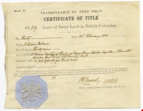
Certificate of Title
https://search.heritageburnaby.ca/link/museumdescription10407
- Repository
- Burnaby Village Museum
- Date
- 20 Feb. 1861
- Collection/Fonds
- William Holmes fonds
- Description Level
- Item
- Physical Description
- 1 certificate
- Scope and Content
- Item consists of "Certificate of Title" to Mr. William Holmes for land in Burnaby/NE Westminster; "39 Acres", "20th February 1861". "Description" reads: "25 Chains Frontage on thereby on Fraser River between Coquitlam & Brunette / between Rev. E. White & Col. Moody's [?]". The blue Provincial seal…
- Repository
- Burnaby Village Museum
- Collection/Fonds
- William Holmes fonds
- Description Level
- Item
- Physical Description
- 1 certificate
- Scope and Content
- Item consists of "Certificate of Title" to Mr. William Holmes for land in Burnaby/NE Westminster; "39 Acres", "20th February 1861". "Description" reads: "25 Chains Frontage on thereby on Fraser River between Coquitlam & Brunette / between Rev. E. White & Col. Moody's [?]". The blue Provincial seal is affixed to the certificate and it is signed by R.C. Moody, "Chief Commissioner of Lands and Works".
- Accession Code
- BV997.50.5
- Access Restriction
- No restrictions
- Reproduction Restriction
- No known restrictions
- Date
- 20 Feb. 1861
- Media Type
- Textual Record
- Scan Resolution
- 300
- Scan Date
- 06-May-2019
- Notes
- Title based on contents of item
Images
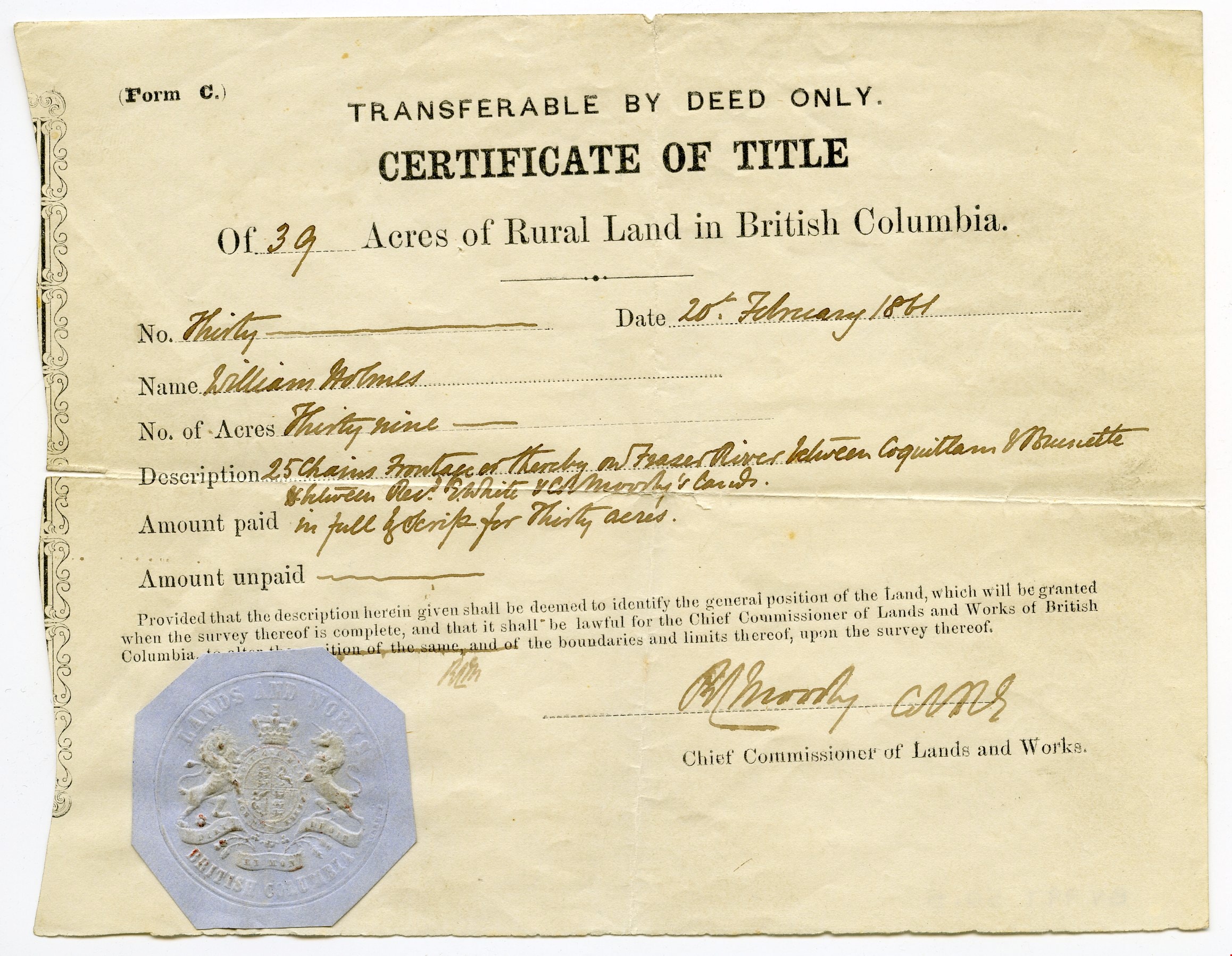
Certificate of Title
https://search.heritageburnaby.ca/link/museumdescription10408
- Repository
- Burnaby Village Museum
- Date
- 22 Mar. 1860
- Collection/Fonds
- William Holmes fonds
- Description Level
- Item
- Physical Description
- 1 certificate
- Scope and Content
- Item consists of "Certificate of Title" to Mr. William Holmes for land in Burnaby/NE Westminster; "40 Acres", "Twenty Second Day of March AD 1860". Description reads: "On West Side at termination of North Road to Port Moody Burrard Inlet". The blue Provincial seal is affixed to the certificate and…
- Repository
- Burnaby Village Museum
- Collection/Fonds
- William Holmes fonds
- Description Level
- Item
- Physical Description
- 1 certificate
- Scope and Content
- Item consists of "Certificate of Title" to Mr. William Holmes for land in Burnaby/NE Westminster; "40 Acres", "Twenty Second Day of March AD 1860". Description reads: "On West Side at termination of North Road to Port Moody Burrard Inlet". The blue Provincial seal is affixed to the certificate and it is signed by R.C. Moody, "Chief Commissioner of Lands and Works".
- Accession Code
- BV997.50.6
- Access Restriction
- No restrictions
- Reproduction Restriction
- No known restrictions
- Date
- 22 Mar. 1860
- Media Type
- Textual Record
- Scan Resolution
- 300
- Scan Date
- 06-May-2019
- Notes
- Title based on contents of item
Images
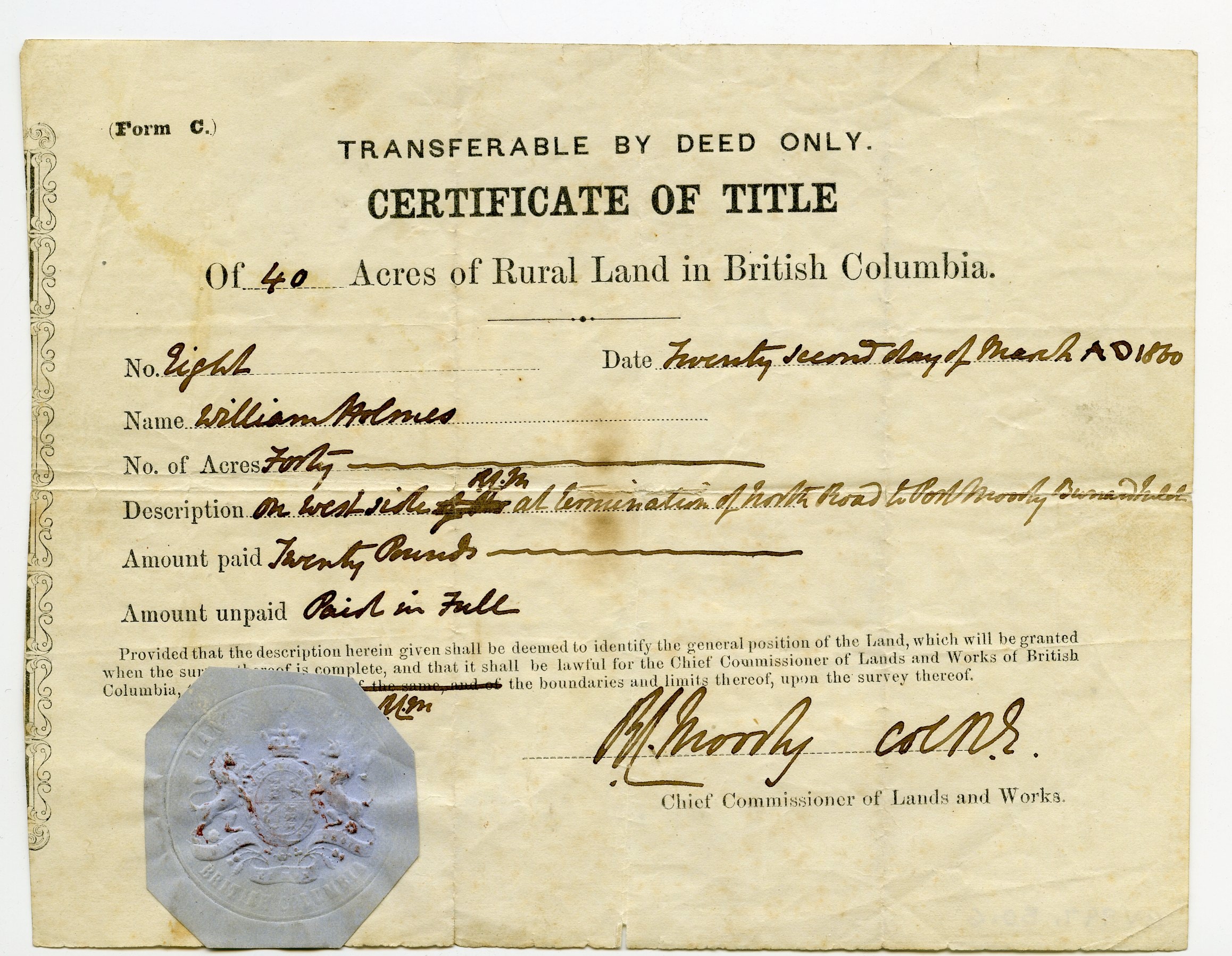
Certificate of Title
https://search.heritageburnaby.ca/link/museumdescription10409
- Repository
- Burnaby Village Museum
- Date
- 22 Mar. 1860
- Collection/Fonds
- William Holmes fonds
- Description Level
- Item
- Physical Description
- 1 certificate
- Scope and Content
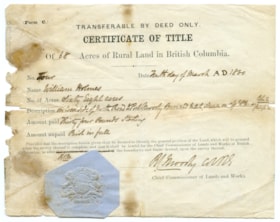
- Item consists of "Certificate of Title" to Mr. William Holmes for land in Burnaby/NE Westminster; "68 Acres", "Tenth Day of March AD 1860". Description reads: "On West Side of North Road to Port Moody Burrard Inlet, shown on the [?] Plan as Lots 2 / Group 1". The blue Provincial seal is affixed to…
- Repository
- Burnaby Village Museum
- Collection/Fonds
- William Holmes fonds
- Description Level
- Item
- Physical Description
- 1 certificate
- Scope and Content
- Item consists of "Certificate of Title" to Mr. William Holmes for land in Burnaby/NE Westminster; "68 Acres", "Tenth Day of March AD 1860". Description reads: "On West Side of North Road to Port Moody Burrard Inlet, shown on the [?] Plan as Lots 2 / Group 1". The blue Provincial seal is affixed to the certificate and it is signed by R.C. Moody "Chief Commissioner of Lands and Works".
- Accession Code
- BV997.50.7
- Access Restriction
- No restrictions
- Reproduction Restriction
- No known restrictions
- Date
- 22 Mar. 1860
- Media Type
- Textual Record
- Scan Resolution
- 300
- Scan Date
- 06-May-2019
- Notes
- Title based on contents of item
Images
Hill family and Vidal family fonds
https://search.heritageburnaby.ca/link/archivedescription82116
- Repository
- City of Burnaby Archives
- Date
- [1850-1983]
- Collection/Fonds
- Hill family and Vidal family fonds
- Description Level
- Fonds
- Physical Description
- 255 photographs : b&w and sepia and 9.5 cm of textual records : ill. (some col.)
- Scope and Content
- Fonds consists of photographs and textual records from the Vidal and Hill family. Textual records include handwritten family trees, typed and handwritten biographical information of the Jones, Wright, Hyde, Vidal, and Hill families, copies of photographic prints, published works by J. H. Vidal and …
- Repository
- City of Burnaby Archives
- Date
- [1850-1983]
- Collection/Fonds
- Hill family and Vidal family fonds
- Physical Description
- 255 photographs : b&w and sepia and 9.5 cm of textual records : ill. (some col.)
- Description Level
- Fonds
- Access Restriction
- No restrictions
- Accession Number
- 2013-03
- Scope and Content
- Fonds consists of photographs and textual records from the Vidal and Hill family. Textual records include handwritten family trees, typed and handwritten biographical information of the Jones, Wright, Hyde, Vidal, and Hill families, copies of photographic prints, published works by J. H. Vidal and William Cowper, newspaper clippings, and a New Testament.
- History
- Minard Gerald “Gerry” Hill was born in Burnaby on July 31, 1893, to Marian (nee Berkeley) and Bernard Richard Hill. Marian was born in London, England. Bernard Hill, born in Bengal, India, in 1858 to Sir Richard Hill and Jane Ann (nee Rollinson) where his father worked for the East Indian Railway, was one of the early inhabitants of Burnaby. Despite their years of training as engineers, Bernard, along with his brother, Louis Claude Hill, became strawberry farmers and owned all the land between Burnaby Lake and Deer Lake where Deer Creek runs, and halfway around Deer Lake. Bernard built his family home at Douglas Road near Deer Lake in 1892. After the decline in the strawberry industry, Bernard worked as a surveyor for the municipality. Bernard also served as a Burnaby trustee and as councilor of Burnaby in 1904, 1905, 1906, and 1909. Bernard and Marian had four children: A. Claude (born in England around 1885, married Marion “Mamie”), Frank L., Winnifred “Winnie” L., and Gerry. Gerry attended Miss Harriet Woodward’s kindergarten class, and went on to Edmonds School with Miss Ellen Lister as his teacher. He later went to Central High School in New Westminster, often on horseback. Gerry served in World War I, signing his recruitment papers on November 9, 1914. When he returned home, he worked felling trees, then as an apprentice surveyor and finally as a carpenter. His father, Bernard, died in Burnaby on March 27, 1939, at the age of 80. Bernard's brother, Louis, was one of the first members elected to the Burnaby council and served in 1892, 1893, 1894, and again from 1909-1910. Louis, born in 1860, married Annie Sarah Kendrick (born in 1896) and they moved to the Burnaby Lake area in the early 1890s. Together they had one child, Katherine “Kitty” Maude, born in 1898. The first Hill family home, “Brookfield,” was sold around 1907 and the family moved to their new home, “Broadview,” which was also built in the vicinity of Deer Lake. Kitty, their only child, married William “Bob” John Peers in 1925 and they went on to have three children: Robert C.K., Barbara (later Barbara Jeffrey), and Anne (later Anne Latham). Charlotte Elizabeth Vidal was born in 1897 in the United States to Louisa Sophia (nee Jones) and Herbert P. Vidal. Louisa Vidal (1871-1943) was a descendent of Jones of Exeter of England and the House of Llanio Cardigan of Wales. Herbert Vidal (1868-1934)’s father was Alexander Vidal (1819-1906). Alexander Vidal, born in Brocknell, England, immigrated to Upper Canada in 1835 and later served as a senator of Canada from 1873 to 1906. He married Catherine Louisa Wright, the daughter of Capt. William Elliot Wright. Both of Charlotte’s parents, Louisa and Herbert, were born in Ontario. Charlotte Vidal was sister to Dorothy Kate and Alexander E. E. Vidal. Gerry Hill (aged 27) and Charlotte E. Vidal (aged 23) married on September 28, 1920, in Vancouver. Gerry built a house for him and his wife about a thousand feet from his parents’ home. He also bought property at Yellow Point on Vancouver Island around this time. By the early 1930s, Gerry had moved to Yellow Point permanently and begun building the Yellow Point Lodge. Gerry and Charlotte bore three children: David, Lesley C. (born in 1929), and Gerald. Gerry was later remarried to Elizabeth (nee Holen) and had one child: Richard Grant McEwan Hill, born in Ladysmith. Lesley married M. Clarke and had two boys: Roy and Graham. She later married B. Durban and had four boys: Patrick, Michael, Gary, and Grant. Charlotte died on February 11, 1984, at the age of 87. Gerry died on January 30, 1988, in Ladysmith at the age of 93.
- Media Type
- Photograph
- Textual Record
- Creator
- Hill Family
- Vidal family
- Notes
- Title based on contents of fonds
- Photo catalogue 550, MSS176
![Survey and Subdivision plans in New Westminster District Group 1 – Burnaby
, [1861]-[1910] thumbnail](/media/hpo/_Data/_BVM_Cartographic_Material/1977/1977_0093_0019a_001.jpg?width=280)
Survey and Subdivision plans in New Westminster District Group 1 – Burnaby
https://search.heritageburnaby.ca/link/museumdescription6988
- Repository
- Burnaby Village Museum
- Date
- [1861]-[1910]
- Collection/Fonds
- Burnaby Village Museum Map collection
- Description Level
- File
- Physical Description
- 14 plans : 3 plans : black ink on paper hand col. + 7 plans : black ink on paper + 4 plans : graphite on paper mounted on 2 sides of cardboard 76 x 102 cm
- Scope and Content
- Item consists of a large board of four New Westminster District Gp 1 - subdivision plans mounted on one side and ten New Westminster District Gp 1 - subdivision plans mounted on the other side. Side A: 1. "Plan /of / Lots 166A, 166 and 167 /, Gr.1, N.W.D. / Showing Misconstructed Roads in Gree…
- Repository
- Burnaby Village Museum
- Collection/Fonds
- Burnaby Village Museum Map collection
- Description Level
- File
- Physical Description
- 14 plans : 3 plans : black ink on paper hand col. + 7 plans : black ink on paper + 4 plans : graphite on paper mounted on 2 sides of cardboard 76 x 102 cm
- Material Details
- Scales [between 1:2376 and 1:7920]
- Index number on edge of board reads: "19"
- Scope and Content
- Item consists of a large board of four New Westminster District Gp 1 - subdivision plans mounted on one side and ten New Westminster District Gp 1 - subdivision plans mounted on the other side. Side A: 1. "Plan /of / Lots 166A, 166 and 167 /, Gr.1, N.W.D. / Showing Misconstructed Roads in Green / 5 chs = 1 in.". (plan is drawn in black ink and hand coloured in red, green and orange ink). A section in the centre of the plan is coloured in red ink and identified as "C.S. Richmond" running from the North Arm of Fraser River to Wiggins Road and divided by "New Wiggins Rd. (as gazetted)" (coloured in orange ink) and two"Constructed Road(s)" (coloured in green ink). Plan is initialed by: "RB" [sic] (in blue pencil crayon) 2. Plan of / Subdivision of / Lot 166 / Group One / New Westminster District / Scale 4 chs = 1 in. / Map No 524". Plan is drawn in graphite and signed by "Surrig [sic] Welhams [sic] / P.L.S." Plan is initialed by: "RB" [sic] (in blue pencil crayon) 3. Plan of "Survey / of Highway / For / Burnaby Council / in / Lots 13 _14 / Group One / Scale 4 chs = 1 in." Signed by "Albert J. Hill, P.L.S." Caribou Street and Caribou Road run through the centre of the plan. Plan is stamped: "Albert J. Hill, Civil Engineer / and / Provincial Land Surveyor, / New Westminster, / B.C.". Plan is initialed by: "RB" [sic] (in blue pencil crayon) 4. A Plan of Lots 166A, 166 and 167, Group One, New Westminster District (drawn in graphite). A section in the centre of the plan is identified as "C.S. Richmond" running from the North Arm of Fraser River and divided by "New Wiggins Rd. (as gazetted)" and two "Constructed Road(s)". Plan is initialed by: "RB" [sic] (in blue pencil crayon) Side B: 1. Small plan drawn in black ink (no title) identifying lots north of the "North Arm" of the Fraser River. Lots identified include: Lot 99, Lot 98, Lot 157, Lot 158, Lot 163, Lot 162, Lot 159, Lot 163, Lot 162, Lot 165, Lot 166A, Lot 155B, Lot 155A and Lot 159. "Scale 40 chains to one inch" . Plan is initialed by: "RB" [sic] (in blue pencil crayon) (Geographic location: Burnaby) 2. Small plan drawn in black ink (no title) identifying lots north of the North Arm of the Fraser River as "Lots 155, 155A, 155B, 155C, 162, 163, 164, 165, 166A and 167". Plan is initialed by: "RB" [sic] (in blue pencil crayon) (Geographic location: Burnaby) 3. Small plan drawn in black ink (no title) which identifies "Lot 151 / Reserve/ for / Race Course"; "Reserve / 64 A / L. 152 G.1"; and other Lots: 32, 33, 34, 35, 36, 38, 39. The plan is signed "Surveyor G.Turn [sic] July / 61 / from Vol 40 R.L. notes [sic]" Plan is stamped: "Albert J. Hill, Civil Engineer / and / Provincial Land Surveyor, / New Westminster, / B.C." Plan is initialed by: "RB" [sic] (in blue pencil crayon) (Geographic location: Burnaby) 4. Small plan drawn in black in with faded red colouring on centre lot identified as "Lot 34" running north from "Vancouver Road" . Plan is stamped: "Albert J. Hill, Civil Engineer / and / Provincial Land Surveyor, / New Westminster, / B.C." Plan is initialed by: "RB" [sic] (in blue pencil crayon) (Geographic location: Burnaby) 5. Plan drawn in graphite and identified as "Lot 98, Gr.1," along with the intials "RB" [sic] (both are handwritten in blue crayon pencil on top of plan) The B.C.E.Railway is identified running through the plan along with Jubilee Road and Royal Oak Road. The plan is signed with the name "Wm. Murray" and the Plan is stamped: "Albert J. Hill, Civil Engineer / and / Provincial Land Surveyor, / New Westminster, / B.C.". (Geographic location: Burnaby) 6. Plan drawn in graphite identified as "Port Lot 13, Gr.1" along with the intials "RB" [sic] (both are handwritten in blue crayon pencil on top of plan) Plan is stamped: "Albert J. Hill, Civil Engineer / and / Provincial Land Surveyor, / New Westminster, / B.C.". (Geographic location: Burnaby) 7.Plan drawn in black ink and identified as "Lot 98 G.1" along with the intials "RB" [sic] (both are handwritten in blue crayon pencil on top of plan). A "Road Reservation" is identified running north between "Electric Tramway" and connecting with "Royal Oak Road". Plan is stamped: "Albert J. Hill, Civil Engineer / and / Provincial Land Surveyor, / New Westminster, / B.C." (Geographic location: Burnaby) 8. Plan drawn in black ink and divided into two sections, the upper plan is identified as "Portion / Lots 100 / area / 101, Gr.1" and the lower plan is identified as "Portion L. 3 G. 1" along with the intials "RB" [sic] (these identifiers are handwritten in blue crayon pencil on top of the plan). Portions of Lot 100 and Lot 101 are each divided into 6 sections and the Portion of Lot 3 plan is divided into 24 sections. The plan includes a note in black ink that reads: " Received from Wm Fromme [sic] / from Wm. Trapp / Nov. 28, 1895 / A. J. T...[sic]". (Geographic location: Burnaby) 9. Plan drawn in black ink (no title) identifying soil, buildings and geographic features in southern Burnaby. The plan is bordered by "New Westminster City" (Tenth Avenue and DL 172) to the south east and DL 173 to the south, DL 158 to the west and the B.C.E. Tramway to the north. Plan includes District Lots: 155A, 158, 159, 171, 160, 53 and 95 and identifies soil, marshland and ravines throughout. Plan identifies the following features: a "Team Road" running through Lots 158 and 159 along with "Fair Orchard Soil / Even Surface Throughout / No Ravines", "Gravel and Shingle" (bottom of Lot 158), "North Arm Road" crossing "Byrne Road" and connecting with "Power House Road" which runs north to connect with "Highland Park Station" and the B.C.E. Tramway, "Power Ho" in the northeast corner of DL 160, a "Brook" connected with a "Deep Ravine" running between DL 53, DL 95 and DL 160 along with "Good Soil" and "Fair Orchard Soil" identified nearby in DL 95. Scale is identified as "10 chs = 1 in." Plan is stamped: "Albert J. Hill, Civil Engineer / and / Provincial Land Surveyor, / New Westminster, / B.C." Plan is initialed by: "RB" [sic] (in blue pencil crayon) (Geographic location: Burnaby) 10. Plan drawn in black ink (no title) with Burnaby Lake and Deer Lake at the centre. The plan is bordered by the following District Lots identified as: 117, 118 and 68 to the west, Lots 80, 79 and 85 to the southwest, Lots 11, 13, and 1 (City of New Westminster) to the south east, the North Road boundary to the east and Lots 8, 56, 57, 59, and 136 to the North. The lower right hand corner of the plan has a small inset which reads: "Burnaby Lake" and "Page 19 R.B. Notes". Plan is initialed by: "RB" [sic] (in blue pencil crayon) (Geographic location: Burnaby)
- Creator
- Hill, Albert James
- Accession Code
- HV977.93.19
- Access Restriction
- No restrictions
- Reproduction Restriction
- No known restrictions
- Date
- [1861]-[1910]
- Media Type
- Cartographic Material
- Scan Resolution
- 300
- Scale
- 72
- Notes
- Title based on contents of file
- Scale is measured in chains. (One chain equals 792 inches)
- The term "Lot" can also refer to a "District Lot”
- Some plans are stamped: "Albert J. Hill, Civil Engineer / and / Provincial Land Surveyor, / New Westminster, / B.C." and intialed: "RB" [sic]
Images
![Survey and Subdivision plans in New Westminster District Group 1 – Burnaby
, [1861]-[1910] thumbnail](/media/hpo/_Data/_BVM_Cartographic_Material/1977/1977_0093_0019a_001.jpg)

![Survey and Subdivision plans in New Westminster District Group 1 – Burnaby, Port Moody, [1862-1908] thumbnail](/media/hpo/_Data/_BVM_Cartographic_Material/1977/1977_0093_0026a_001.jpg?width=280)
Survey and Subdivision plans in New Westminster District Group 1 – Burnaby, Port Moody
https://search.heritageburnaby.ca/link/museumdescription6995
- Repository
- Burnaby Village Museum
- Date
- [1862-1908]
- Collection/Fonds
- Burnaby Village Museum Map collection
- Description Level
- File
- Physical Description
- 9 plans : 6 plans : black ink on paper ; 57 x 36.5 cm or smaller + 1 plan : black ink and grahite on paper ; 46.5 x 49 cm + 1 plan : blueprint on paper ; 15.5 x 19.5 cm + cm + 1 plan : graphite on paper ; 25 x 17 cm ; mounted on both sides of board 76 x 102 cm
- Scope and Content
- Item consists of a large board of four New Westminster District subdivision plans mounted on one side and five New Westminster District subdivision plans mounted on the other side. Side A: 1. "Plan / of Subdivision / of a Portion / of / Lot 87 / Group One / New Westminster District / Scale 4 chs…
- Repository
- Burnaby Village Museum
- Collection/Fonds
- Burnaby Village Museum Map collection
- Description Level
- File
- Physical Description
- 9 plans : 6 plans : black ink on paper ; 57 x 36.5 cm or smaller + 1 plan : black ink and grahite on paper ; 46.5 x 49 cm + 1 plan : blueprint on paper ; 15.5 x 19.5 cm + cm + 1 plan : graphite on paper ; 25 x 17 cm ; mounted on both sides of board 76 x 102 cm
- Material Details
- Scales [between 1:792 and 1:3600]
- Index number on edge of board reads: "26"
- Scope and Content
- Item consists of a large board of four New Westminster District subdivision plans mounted on one side and five New Westminster District subdivision plans mounted on the other side. Side A: 1. "Plan / of Subdivision / of a Portion / of / Lot 87 / Group One / New Westminster District / Scale 4 chs = 1 in". Plan is stamped: "Albert J. Hill, Civil Engineer / and / Provincial Land Surveyor, / New Westminster, / B.C." and intialed by: "RB" [sic] (in blue pencil crayon). Names two of the subdivisons of District Lot 87 are identified as, "L.E. Sprott" and "John Ledger". (Geographic location: Burnaby) 2. "Plan of Subdivision / of / Portions of / Lot 136, 131 and Lots 44 and 78 Gr.1 / New Westminster District / Scale 300 ft = 1 inch". Annotation above title reads: "No. 901 / Deposited in Land Registry Office / New Westminster / Aug. 19th 1905 / Charles S. Keith D. Reg." Annotations and signatures at bottom of plan read: "I, William Nelson Draper, / W.H.R. Collister / Charles E. Perkins / E.B. Morgan / make / Surveys / correct / representation / upon / the / Land Registry Act / (sgd) W.N. Draper, P.L.S.". Plan includes a handwritten title: "Lots 136, 131, 44 & 78" and is initialed: "RB" [sic] (in blue pencil crayon) (Geographic location: Burnaby) 3. "Survey / of / a Portion / of / Lot 95, Gr.1 / Scale 1 ch = 1in." Plan is stamped: "Albert J. Hill, Civil Engineer / and / Provincial Land Surveyor, / New Westminster, / B.C." and is initialed : "RB" [sic] (in blue pencil crayon) (Geographic location: Burnaby) 4. Blueprint plan of "Lot 396. Group One." with Scale : 3 chs = 1 in. A two acre portion of District Lot 396 is filled in with red ink." Plan is signed by "Albert J. Hill / B.C.L.S." (Geographic location: Port Moody) Side B: 1. Plan titled "District Lot 92 / Burnaby / Municipality / for sale by / Mahon / McFarland & / Mahon Ltd. / Vancouver, B.C. / Scale : 4 chains to one inch". District Lot 92 is subdivided into 161 lots and identifies roads: Norwich Road, Pole Line Road, Oakland Road, Stanley Road, Burford Road, Dalhousie Road, Brantford Road, Colborne Road, Roberts Road, Vancouver & Westminster Road, B.C. Electric Railway, Gilley Stn. and Burnaby (Power House). The bottom of the plan reads: "G.S. Dawson, P.LS. Vancouver, B.C." (Geographic location: Burnaby) 2. "Plan / of Subdivision / of a Portion / of / Lot 29 / Group 1 / New Westminster District / Scale 2 chs = 1 in". Plan is stamped: "Albert J. Hill, Civil Engineer / and / Provincial Land Surveyor, / New Westminster, / B.C." and is initialed by: "RB" [sic] (in blue pencil crayon) (Geographic location: Burnaby) 3. Small handrawn plan (no title) identifying "Lot 84 / Hydes, Claim" at the centre surrounded by lots and features identified as: "Lot 85", "Lot 93", "Lot 94", "Lot 32", "Lot 82", "Lot 83", "Lot 79", "swamp" and a "Small Lake" (Burnaby Lake). Identifying marks in the right corner of the plan read: "Page 13 / Surveyed by G. Turner / May 62". Plan also includes surveyor's bearing measurements and trails to "Small Lake" (Burnaby Lake). (Geographic location: Burnaby) 4. Untitled plan showing District Lots west of North Road and north of Burnaby Lake including: Lots 2, 4, 6, 8, 15, 10, 56, 148, 57, 58, 40. and Lots 3, 5, 7 east of North Road (Coquitlam). Lots in Burnaby are identifed for timber including: "Heavily Timbered" (Lot 57), " "Some Fir and Cedar" (Lot 40), "Splendid Fir and Cedar" (Lot 143), "Heavy Fir etc" (Lots 143 and 148), " "Fine Cedar" (Lot 15), "Rough Light Timber" (Lot 56). Other features identified at the lower portion of the plan include "Burnaby Lake" and "Brunette River". (Geographic location: Burnaby) 5. Untitled plan drawn in graphite showing sections of District Lot 85 south of Burnaby Lake and north of Hazsard Road. Plan is signed: "Albert J. Hill / B.C.L.S." and dated "12/26/08". Plan is initialed by: "RB" [sic] (in blue pencil crayon) (Geographic location: Burnaby)
- Publisher
- Mahon, McFarland & Mahon Ltd
- Accession Code
- HV977.93.26
- Access Restriction
- No restrictions
- Reproduction Restriction
- No known restrictions
- Date
- [1862-1908]
- Media Type
- Cartographic Material
- Historic Neighbourhood
- Burnaby Lake (Historic Neighbourhood)
- Burquitlam (Historic Neighbourhood)
- Planning Study Area
- Burnaby Lake Area
- Scan Resolution
- 300
- Scale
- 72
- Notes
- Title based on contents of file
- Scale is measured in chains and feet. (One chain equals 792 inches)
- The term "Lot" can also refer to a "District Lot”
Images
![Survey and Subdivision plans in New Westminster District Group 1 – Burnaby, Port Moody, [1862-1908] thumbnail](/media/hpo/_Data/_BVM_Cartographic_Material/1977/1977_0093_0026a_001.jpg)

