
Safeway Disco Centre
https://search.heritageburnaby.ca/link/archivedescription79963
- Repository
- City of Burnaby Archives
- Date
- October 20, 1976
- Collection/Fonds
- Burnaby Public Library Contemporary Visual Archive Project
- Description Level
- Item
- Physical Description
- 1 photograph : b&w ; 11 x 16 cm mounted on cardboard
- Scope and Content
- Photograph shows a view of the Safeway Disco Centre at Kingsway and Edmonds Street looking southeast from Hall Towers.
- Repository
- City of Burnaby Archives
- Date
- October 20, 1976
- Collection/Fonds
- Burnaby Public Library Contemporary Visual Archive Project
- Physical Description
- 1 photograph : b&w ; 11 x 16 cm mounted on cardboard
- Description Level
- Item
- Record No.
- 556-526
- Access Restriction
- No restrictions
- Reproduction Restriction
- Reproduce for fair dealing purposes only
- Accession Number
- 2013-13
- Scope and Content
- Photograph shows a view of the Safeway Disco Centre at Kingsway and Edmonds Street looking southeast from Hall Towers.
- Subjects
- Aerial Photographs
- Names
- Safeway Disco Centre
- Media Type
- Photograph
- Photographer
- Ross, Martha
- Notes
- Scope note taken directly from BPL photograph description.
- 1 b&w copy negative : 10 x 12.5 cm accompanying
- Geographic Access
- Kingsway
- Edmonds Street
- Historic Neighbourhood
- Edmonds (Historic Neighbourhood)
- Planning Study Area
- Stride Avenue Area
Images


Royal Oak Hotel
https://search.heritageburnaby.ca/link/landmark726
- Repository
- Burnaby Heritage Planning
- Geographic Access
- Kingsway
- Associated Dates
- 1891
- Heritage Value
- One of the most notorious landmarks in Burnaby was the Royal Oak Hotel, constructed around 1891 at the present-day northeast corner of Kingsway and Royal Oak. Levis Morrison built the hotel, then sold out to Charles Cridland, whose poor hotel reputation prompted Burnaby council to hire its second police constable. The hotel continued to operate until 1973 when it was demolished to build a Safeway store.
- Historic Neighbourhood
- Central Park (Historic Neighbourhood)
- Planning Study Area
- Marlborough Area
- Street View URL
- Google Maps Street View
Images


Edmonds Bus Loop
https://search.heritageburnaby.ca/link/archivedescription34602
- Repository
- City of Burnaby Archives
- Date
- July 15, 1966
- Collection/Fonds
- Burnaby Historical Society fonds
- Description Level
- Item
- Physical Description
- 1 photograph : b&w negative ; 4.4 x 4.6 cm
- Scope and Content
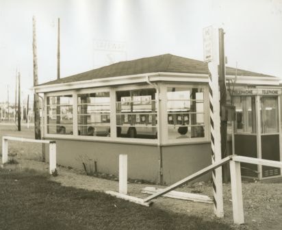
- Photograph of the Edmonds Bus Loop at Edmonds Street and Kingsway, including a bus shelter and telephone booth with a broken fence in front. A Safeway sign can be seen in the background.
- Repository
- City of Burnaby Archives
- Date
- July 15, 1966
- Collection/Fonds
- Burnaby Historical Society fonds
- Subseries
- Photographs subseries
- Physical Description
- 1 photograph : b&w negative ; 4.4 x 4.6 cm
- Description Level
- Item
- Record No.
- 066-006
- Access Restriction
- No restrictions
- Reproduction Restriction
- Reproduce for fair dealing purposes only
- Accession Number
- BHS2007-04
- Scope and Content
- Photograph of the Edmonds Bus Loop at Edmonds Street and Kingsway, including a bus shelter and telephone booth with a broken fence in front. A Safeway sign can be seen in the background.
- Subjects
- Transportation - Public Transit
- Media Type
- Photograph
- Notes
- Title based on contents of photograph
- 1 b&w photograph accompanying
- Geographic Access
- Kingsway
- Edmonds Street
- Historic Neighbourhood
- Edmonds (Historic Neighbourhood)
- Planning Study Area
- Stride Avenue Area
Images
![Home Station at Royal Oak and Kingsway, [1950] (date of original), copied [1999] thumbnail](/media/hpo/_Data/_BVM_Images/1990/199900180001.jpg?width=280)
Home Station at Royal Oak and Kingsway
https://search.heritageburnaby.ca/link/museumdescription1381
- Repository
- Burnaby Village Museum
- Date
- [1950] (date of original), copied [1999]
- Collection/Fonds
- Burnaby Village Museum Photograph collection
- Description Level
- Item
- Physical Description
- 1 photograph : sepia ; 15 x 25.5 cm laser print
- Scope and Content
- Photograph of Home Station owned by Ted Hopper located at Royal Oak and Kingsway. Edward Tarling is visible operating a Model 'C' Oliver tractor to clear the snow out front.
- Repository
- Burnaby Village Museum
- Collection/Fonds
- Burnaby Village Museum Photograph collection
- Description Level
- Item
- Physical Description
- 1 photograph : sepia ; 15 x 25.5 cm laser print
- Scope and Content
- Photograph of Home Station owned by Ted Hopper located at Royal Oak and Kingsway. Edward Tarling is visible operating a Model 'C' Oliver tractor to clear the snow out front.
- Names
- Tarling, Edward
- Geographic Access
- Royal Oak Avenue
- Kingsway
- Accession Code
- BV999.18.1
- Access Restriction
- Restricted access
- Reproduction Restriction
- May be restricted by third party rights
- Date
- [1950] (date of original), copied [1999]
- Media Type
- Photograph
- Historic Neighbourhood
- Central Park (Historic Neighbourhood)
- Planning Study Area
- Windsor Area
- Scan Resolution
- 600
- Scan Date
- 08-Jun-09
- Scale
- 100
- Notes
- Title based on contents of photograph
- Note on recto of laser print reads: "HOME STATION - AT ROYAL OAK & Kingway [sic] (Now SAFEWAY) BURNABY STATION OWNED BY MR. TED HOPPER - - 1950 - ED TARLING OPERATING 'C' model OLIVER TRACTOR"
Images
![Home Station at Royal Oak and Kingsway, [1950] (date of original), copied [1999] thumbnail](/media/hpo/_Data/_BVM_Images/1990/199900180001.jpg)
![Police officer at Royal Oak and Kingsway, [1999] thumbnail](/media/hpo/_Data/_Archives_Images/_Unrestricted/535/535-3258.jpg?width=280)
Police officer at Royal Oak and Kingsway
https://search.heritageburnaby.ca/link/archivedescription98180
- Repository
- City of Burnaby Archives
- Date
- [1999]
- Collection/Fonds
- Burnaby NewsLeader photograph collection
- Description Level
- Item
- Physical Description
- 1 photograph (tiff) : col.
- Scope and Content
- Photograph of a Burnaby RCMP officer wearing a reflective vest and standing on the sidewalk by a bus stop on Kingsway, across the street from a Safeway, at the intersection of Royal Oak Avenue and Kingsway.
- Repository
- City of Burnaby Archives
- Date
- [1999]
- Collection/Fonds
- Burnaby NewsLeader photograph collection
- Physical Description
- 1 photograph (tiff) : col.
- Description Level
- Item
- Record No.
- 535-3258
- Access Restriction
- No restrictions
- Reproduction Restriction
- No restrictions
- Accession Number
- 2018-12
- Scope and Content
- Photograph of a Burnaby RCMP officer wearing a reflective vest and standing on the sidewalk by a bus stop on Kingsway, across the street from a Safeway, at the intersection of Royal Oak Avenue and Kingsway.
- Subjects
- Occupations - Police Officers
- Geographic Features - Roads
- Buildings - Commercial - Grocery Stores
- Media Type
- Photograph
- Notes
- Title based on contents of photograph
- Collected by editorial for use in a July 1999 issue of the Burnaby NewsLeader
- Geographic Access
- Kingsway
- Royal Oak Avenue
- Historic Neighbourhood
- Central Park (Historic Neighbourhood)
- Planning Study Area
- Windsor Area
Images
![Police officer at Royal Oak and Kingsway, [1999] thumbnail](/media/hpo/_Data/_Archives_Images/_Unrestricted/535/535-3258.jpg)