Narrow Results By
Subject
- Buildings - Commercial - Offices 1
- Buildings - Heritage 1
- Buildings - Religious - Churches 2
- Buildings - Residential - Apartments 1
- Buildings - Residential - Houses 3
- Documentary Artifacts - Certificates 2
- Documentary Artifacts - Postcards 2
- Geographic Features - Roads 3
- Public Services - Correctional 1
- Transportation - Snowploughs 2
- Transportation - Tractors 2
![England family home on Royal Oak Avenue, [between 1927 and 1930] (date of original) , copied 2020 thumbnail](/media/hpo/_Data/_BVM_Images/2020/2020_0009_0002_001.jpg?width=280)
England family home on Royal Oak Avenue
https://search.heritageburnaby.ca/link/museumdescription12230
- Repository
- Burnaby Village Museum
- Date
- [between 1927 and 1930] (date of original) , copied 2020
- Collection/Fonds
- Mary England fonds
- Description Level
- Item
- Physical Description
- 1 photograph (tiff) : b&w ; 600 dpi
- Scope and Content
- Photograph of a Craftsman style house located at 1906 Royal Oak Avenue near Victory Street in Burnaby (address was changed to 7353 Royal Oak Aveue after 1958). The house was built in 1914 and was the home of Alfred Henry and Mary England (nee Gooding). Alfred H. England died suddenly in 1917. Mary…
- Repository
- Burnaby Village Museum
- Collection/Fonds
- Mary England fonds
- Description Level
- Item
- Physical Description
- 1 photograph (tiff) : b&w ; 600 dpi
- Scope and Content
- Photograph of a Craftsman style house located at 1906 Royal Oak Avenue near Victory Street in Burnaby (address was changed to 7353 Royal Oak Aveue after 1958). The house was built in 1914 and was the home of Alfred Henry and Mary England (nee Gooding). Alfred H. England died suddenly in 1917. Mary England continued to live in the house before settling in a house that she had built on Griffiths Avenue in 1930.
- Subjects
- Buildings - Residential - Houses
- Geographic Access
- Royal Oak Avenue
- Victory Street
- Accession Code
- BV020.9.2
- Access Restriction
- No restrictions
- Reproduction Restriction
- May be restricted by third party rights
- Date
- [between 1927 and 1930] (date of original) , copied 2020
- Media Type
- Photograph
- Historic Neighbourhood
- Central Park (Historic Neighbourhood)
- Alta Vista (Historic Neighbourhood)
- Planning Study Area
- Clinton-Glenwood Area
- Scan Resolution
- 600
- Scan Date
- 12-Feb-20
- Scale
- 100
- Notes
- Title based on contents of photograph
Images
![England family home on Royal Oak Avenue, [between 1927 and 1930] (date of original) , copied 2020 thumbnail](/media/hpo/_Data/_BVM_Images/2020/2020_0009_0002_001.jpg)
![All Saints Anglican Church and Parish Hall, [191-] thumbnail](/media/hpo/_Data/_BVM_Images/1977/198000120004.jpg?width=280)
All Saints Anglican Church and Parish Hall
https://search.heritageburnaby.ca/link/museumdescription3032
- Repository
- Burnaby Village Museum
- Date
- [191-]
- Collection/Fonds
- Burnaby Village Museum Photograph collection
- Description Level
- Item
- Physical Description
- 1 photograph : b&w postcard ; 8.8 x 13.9 cm
- Scope and Content
- Photographic postcard of two buildings identified as All Saints Anglican Church and Parish Hall. There are two men in work clothes (cover-alls) standing in between the two buildings. There is a ladder going up to the roof of one building.
- Repository
- Burnaby Village Museum
- Collection/Fonds
- Burnaby Village Museum Photograph collection
- Description Level
- Item
- Physical Description
- 1 photograph : b&w postcard ; 8.8 x 13.9 cm
- Scope and Content
- Photographic postcard of two buildings identified as All Saints Anglican Church and Parish Hall. There are two men in work clothes (cover-alls) standing in between the two buildings. There is a ladder going up to the roof of one building.
- Geographic Access
- Royal Oak Avenue
- Street Address
- 7405 Royal Oak Avenue
- Accession Code
- HV980.12.4
- Access Restriction
- No restrictions
- Reproduction Restriction
- May be restricted by third party rights
- Date
- [191-]
- Media Type
- Photograph
- Historic Neighbourhood
- Alta-Vista (Historic Neighbourhood)
- Planning Study Area
- Sussex-Nelson Area
- Scan Resolution
- 600
- Scan Date
- 2023-09-12
- Notes
- Title based on contents of photograph
Images
![All Saints Anglican Church and Parish Hall, [191-] thumbnail](/media/hpo/_Data/_BVM_Images/1977/198000120004.jpg)
![Alfred Henry England, [1915] (date of original) , copied 2020 thumbnail](/media/hpo/_Data/_BVM_Images/2020/2020_0009_0005_001.jpg?width=280)
Alfred Henry England
https://search.heritageburnaby.ca/link/museumdescription12233
- Repository
- Burnaby Village Museum
- Date
- [1915] (date of original) , copied 2020
- Collection/Fonds
- Mary England fonds
- Description Level
- Item
- Physical Description
- 1 photograph (tiff) : b&w ; 600 dpi
- Scope and Content
- Photograph of Alfred Henry England (husband of Mary England) walking home from work. He is walking along a boardwalk on Royal Oak Avenue in Burnaby.
- Repository
- Burnaby Village Museum
- Collection/Fonds
- Mary England fonds
- Description Level
- Item
- Physical Description
- 1 photograph (tiff) : b&w ; 600 dpi
- Scope and Content
- Photograph of Alfred Henry England (husband of Mary England) walking home from work. He is walking along a boardwalk on Royal Oak Avenue in Burnaby.
- Names
- England, Alfred Henry
- Geographic Access
- Royal Oak Avenue
- Accession Code
- BV020.9.5
- Access Restriction
- No restrictions
- Reproduction Restriction
- May be restricted by third party rights
- Date
- [1915] (date of original) , copied 2020
- Media Type
- Photograph
- Scan Resolution
- 600
- Scan Date
- 12-Feb-20
- Scale
- 100
- Notes
- Title based on contents of photograph
Images
![Alfred Henry England, [1915] (date of original) , copied 2020 thumbnail](/media/hpo/_Data/_BVM_Images/2020/2020_0009_0005_001.jpg)
![Andrew Johnson house and surrounding property, [1913] thumbnail](/media/hpo/_Data/_BVM_Images/1994/1994_0015_0003_002.jpg?width=280)
Andrew Johnson house and surrounding property
https://search.heritageburnaby.ca/link/museumdescription1189
- Repository
- Burnaby Village Museum
- Date
- [1913]
- Collection/Fonds
- Burnaby Village Museum Photograph collection
- Description Level
- Item
- Physical Description
- 1 photograph : b&w panorama ; 13.5 x 34.5 cm mounted on mattboard 20 x 38 cm
- Scope and Content
- Photograph of the Andrew M. Johnson house "Glenedward" and surrounding property at Kingsway and Royal Oak Avenue. Andrew Johnson built the house around 1911, then occupied the residence until his death in 1934. His wife sold the property in 1943, after which, the place operated as a funeral home un…
- Repository
- Burnaby Village Museum
- Collection/Fonds
- Burnaby Village Museum Photograph collection
- Description Level
- Item
- Physical Description
- 1 photograph : b&w panorama ; 13.5 x 34.5 cm mounted on mattboard 20 x 38 cm
- Material Details
- Panorama was created by printing two negatives and joining them together
- Scope and Content
- Photograph of the Andrew M. Johnson house "Glenedward" and surrounding property at Kingsway and Royal Oak Avenue. Andrew Johnson built the house around 1911, then occupied the residence until his death in 1934. His wife sold the property in 1943, after which, the place operated as a funeral home until 1980 or 1981. The building was then purchased by Wales McLelland development company, then went through a series of restaurant owners' hands.
- Geographic Access
- Kingsway
- Royal Oak Avenue
- Street Address
- 5152 Kingsway
- Accession Code
- BV994.15.3
- Access Restriction
- No restrictions
- Reproduction Restriction
- No known restrictions
- Date
- [1913]
- Media Type
- Photograph
- Historic Neighbourhood
- Central Park (Historic Neighbourhood)
- Planning Study Area
- Marlborough Area
- Scan Resolution
- 600
- Scan Date
- 2024-04-23
- Notes
- Title based on contents of photograph
Images
![Andrew Johnson house and surrounding property, [1913] thumbnail](/media/hpo/_Data/_BVM_Images/1994/1994_0015_0003_002.jpg)
![Home Station at Royal Oak and Kingsway, [1950] (date of original), copied [1999] thumbnail](/media/hpo/_Data/_BVM_Images/1990/199900180001.jpg?width=280)
Home Station at Royal Oak and Kingsway
https://search.heritageburnaby.ca/link/museumdescription1381
- Repository
- Burnaby Village Museum
- Date
- [1950] (date of original), copied [1999]
- Collection/Fonds
- Burnaby Village Museum Photograph collection
- Description Level
- Item
- Physical Description
- 1 photograph : sepia ; 15 x 25.5 cm laser print
- Scope and Content
- Photograph of Home Station owned by Ted Hopper located at Royal Oak and Kingsway. Edward Tarling is visible operating a Model 'C' Oliver tractor to clear the snow out front.
- Repository
- Burnaby Village Museum
- Collection/Fonds
- Burnaby Village Museum Photograph collection
- Description Level
- Item
- Physical Description
- 1 photograph : sepia ; 15 x 25.5 cm laser print
- Scope and Content
- Photograph of Home Station owned by Ted Hopper located at Royal Oak and Kingsway. Edward Tarling is visible operating a Model 'C' Oliver tractor to clear the snow out front.
- Names
- Tarling, Edward
- Geographic Access
- Royal Oak Avenue
- Kingsway
- Accession Code
- BV999.18.1
- Access Restriction
- Restricted access
- Reproduction Restriction
- May be restricted by third party rights
- Date
- [1950] (date of original), copied [1999]
- Media Type
- Photograph
- Historic Neighbourhood
- Central Park (Historic Neighbourhood)
- Planning Study Area
- Windsor Area
- Scan Resolution
- 600
- Scan Date
- 08-Jun-09
- Scale
- 100
- Notes
- Title based on contents of photograph
- Note on recto of laser print reads: "HOME STATION - AT ROYAL OAK & Kingway [sic] (Now SAFEWAY) BURNABY STATION OWNED BY MR. TED HOPPER - - 1950 - ED TARLING OPERATING 'C' model OLIVER TRACTOR"
Images
![Home Station at Royal Oak and Kingsway, [1950] (date of original), copied [1999] thumbnail](/media/hpo/_Data/_BVM_Images/1990/199900180001.jpg)
![Kingsway, [1914] thumbnail](/media/hpo/_Data/_BVM_Images/1971/197200110022.jpg?width=280)
Kingsway
https://search.heritageburnaby.ca/link/museumdescription3108
- Repository
- Burnaby Village Museum
- Date
- [1914]
- Collection/Fonds
- Burnaby Village Museum Photograph collection
- Description Level
- Item
- Physical Description
- 1 photograph : b&w glass negative ; 15.8 x 21.1 cm
- Scope and Content
- Photograph of a paved street lined on both sides with curbs and electric poles. There appears to be a car in the distance, as well as an idustrial building on the right-hand side of the road. An earlier catalogue record from 1988 conjectures that the street is Kingsway, probably in Burnaby, between…
- Repository
- Burnaby Village Museum
- Collection/Fonds
- Burnaby Village Museum Photograph collection
- Description Level
- Item
- Physical Description
- 1 photograph : b&w glass negative ; 15.8 x 21.1 cm
- Scope and Content
- Photograph of a paved street lined on both sides with curbs and electric poles. There appears to be a car in the distance, as well as an idustrial building on the right-hand side of the road. An earlier catalogue record from 1988 conjectures that the street is Kingsway, probably in Burnaby, between Sperling Avenue and Royal Oak, looking South, and that the building is possibly the Macadam making plant for the company which paved Kingsway.
- Subjects
- Geographic Features - Roads
- Geographic Access
- Kingsway
- Sperling Avenue
- Royal Oak Avenue
- Accession Code
- HV972.11.22
- Access Restriction
- No restrictions
- Reproduction Restriction
- No known restrictions
- Date
- [1914]
- Media Type
- Photograph
- Planning Study Area
- Windsor Area
- Scan Resolution
- 300
- Scan Date
- 14/8/2006
- Scale
- 100
- Notes
- Title based on contents of photograph
- 1 b&w contact print accompanying negative
Images
![Kingsway, [1914] thumbnail](/media/hpo/_Data/_BVM_Images/1971/197200110022.jpg)

Neville Street by Royal Oak
https://search.heritageburnaby.ca/link/museumdescription3031
- Repository
- Burnaby Village Museum
- Date
- 1912
- Collection/Fonds
- Burnaby Village Museum Photograph collection
- Description Level
- Item
- Physical Description
- 1 photograph : sepia postcard ; 8.8 x 13.9 cm
- Scope and Content
- Photographic postcard of Neville Street just off Royal Oak Avenue. The street is a dirt road lined with residential buildings on one side and eletric power poles on the other side. The Holdsworth house is seen being constructed on the left. There is scaffolding on the side of the building and a cle…
- Repository
- Burnaby Village Museum
- Collection/Fonds
- Burnaby Village Museum Photograph collection
- Description Level
- Item
- Physical Description
- 1 photograph : sepia postcard ; 8.8 x 13.9 cm
- Scope and Content
- Photographic postcard of Neville Street just off Royal Oak Avenue. The street is a dirt road lined with residential buildings on one side and eletric power poles on the other side. The Holdsworth house is seen being constructed on the left. There is scaffolding on the side of the building and a cleared lot beside the house. here are variant spellings of "Holdsworth" used in the notes in the accession file. They are "Houldsworth" and "Hallsworth." The 1937 British Columbia directory lists a Fred Houldsworth at 3345 Neville Street, Burnaby. The address was later renumbered 5249 Neville Street. An annotation on the back of the postcard reads: "Nevil [sic] Street - 1912 - Just off Royal Oak."
- Subjects
- Buildings - Residential - Houses
- Documentary Artifacts - Postcards
- Geographic Features - Roads
- Geographic Access
- Neville Street
- Royal Oak Avenue
- Accession Code
- HV980.12.3
- Access Restriction
- No restrictions
- Reproduction Restriction
- May be restricted by third party rights
- Date
- 1912
- Media Type
- Photograph
- Historic Neighbourhood
- Alta-Vista (Historic Neighbourhood)
- Planning Study Area
- Clinton-Glenwood Area
- Scan Resolution
- 600
- Scan Date
- 2023-09-12
- Notes
- Title based on contents of photograph
Images

![Royal Oak Apartments, [1950] (date of original), copied [1999] thumbnail](/media/hpo/_Data/_BVM_Images/1990/199900180002.jpg?width=280)
Royal Oak Apartments
https://search.heritageburnaby.ca/link/museumdescription1382
- Repository
- Burnaby Village Museum
- Date
- [1950] (date of original), copied [1999]
- Collection/Fonds
- Burnaby Village Museum Photograph collection
- Description Level
- Item
- Physical Description
- 1 photograph : b&w ; 19.5 x 24.5 cm print
- Scope and Content
- Photograph Edward Tarling running his tractor to plow the snow aside in front of the Royal Oak Apartments.
- Repository
- Burnaby Village Museum
- Collection/Fonds
- Burnaby Village Museum Photograph collection
- Description Level
- Item
- Physical Description
- 1 photograph : b&w ; 19.5 x 24.5 cm print
- Scope and Content
- Photograph Edward Tarling running his tractor to plow the snow aside in front of the Royal Oak Apartments.
- Names
- Tarling, Edward
- Geographic Access
- Kingsway
- Royal Oak Avenue
- Accession Code
- BV999.18.2
- Access Restriction
- Restricted access
- Reproduction Restriction
- May be restricted by third party rights
- Date
- [1950] (date of original), copied [1999]
- Media Type
- Photograph
- Historic Neighbourhood
- Central Park (Historic Neighbourhood)
- Planning Study Area
- Maywood Area
- Scan Resolution
- 600
- Scan Date
- 08-Jun-09
- Scale
- 100
- Notes
- Title based on contents of photograph
- Note in blue pen on verso of photograph reads: "BURNABY HOTEL 1950 CHANGE TO ROYAL OAK APT. BURNABY TAXI IN BACKGROUND INTERCITY LUMBER VERY OWNED MR. DIXON / SOLD TO WAS HANDY MAN of HANDY-PAK-THEM BEAVER LUMBER."
Images
![Royal Oak Apartments, [1950] (date of original), copied [1999] thumbnail](/media/hpo/_Data/_BVM_Images/1990/199900180002.jpg)
![Royal Oak Apartments, [April 1973] thumbnail](/media/hpo/_Data/_BVM_Images/1985/1985_6063_0001_001.jpg?width=280)
Royal Oak Apartments
https://search.heritageburnaby.ca/link/museumdescription1678
- Repository
- Burnaby Village Museum
- Date
- [April 1973]
- Collection/Fonds
- Burnaby Village Museum Photograph collection
- Description Level
- Item
- Physical Description
- 1 photograph : col. ; 8 x 11.5 cm
- Scope and Content
- Photograph of the former Royal Oak Hotel at 3501 Kingsway (renumbered as the 5000 block of Kingsway) and Royal Oak Avenue, with Vancouver Business Maintenance and The Royal Oak Apartments now located in the building.
- Repository
- Burnaby Village Museum
- Collection/Fonds
- Burnaby Village Museum Photograph collection
- Description Level
- Item
- Physical Description
- 1 photograph : col. ; 8 x 11.5 cm
- Scope and Content
- Photograph of the former Royal Oak Hotel at 3501 Kingsway (renumbered as the 5000 block of Kingsway) and Royal Oak Avenue, with Vancouver Business Maintenance and The Royal Oak Apartments now located in the building.
- Names
- Royal Oak Hotel
- Geographic Access
- Kingsway
- Royal Oak Avenue
- Accession Code
- BV985.6063.1
- Access Restriction
- No restrictions
- Reproduction Restriction
- May be restricted by third party rights
- Date
- [April 1973]
- Media Type
- Photograph
- Historic Neighbourhood
- Central Park (Historic Neighbourhood)
- Planning Study Area
- Marlborough Area
- Scan Resolution
- 600
- Scan Date
- 2024-03-05
- Scale
- 100
- Photographer
- Street, Frank
- Notes
- Title based on contents of photograph
- Note written in blue ballpoint pen on verso of photograph reads: "TAKEN BY FRANK STREET"
Images
![Royal Oak Apartments, [April 1973] thumbnail](/media/hpo/_Data/_BVM_Images/1985/1985_6063_0001_001.jpg)
![All Saints Church, [ca.1910] thumbnail](/media/hpo/_Data/_BVM_Cartographic_Material/2003/2003_0083_0046_001.jpg?width=280)
All Saints Church
https://search.heritageburnaby.ca/link/museumdescription11924
- Repository
- Burnaby Village Museum
- Date
- [ca.1910]
- Collection/Fonds
- Ronald G. Scobbie collection
- Description Level
- Item
- Physical Description
- 1 plan : black ink and watercol. on paper ; 30.45 x 30.5 cm
- Scope and Content
- Item consists of building insurance plan of "All Saints Church / Lot "A" BK 29 DL 98 GP1 N.W.D.". Watling Street is idenfied to the north of the church building and Royal Oak Avenue to the west.
- Repository
- Burnaby Village Museum
- Collection/Fonds
- Ronald G. Scobbie collection
- Description Level
- Item
- Physical Description
- 1 plan : black ink and watercol. on paper ; 30.45 x 30.5 cm
- Material Details
- Scale 1 inch = 20 feet
- Scope and Content
- Item consists of building insurance plan of "All Saints Church / Lot "A" BK 29 DL 98 GP1 N.W.D.". Watling Street is idenfied to the north of the church building and Royal Oak Avenue to the west.
- Subjects
- Buildings - Religious - Churches
- Accession Code
- BV003.83.46
- Access Restriction
- No restrictions
- Reproduction Restriction
- No known restrictions
- Date
- [ca.1910]
- Media Type
- Cartographic Material
- Scan Resolution
- 600
- Scan Date
- 15-Jan-2021
- Scale
- 100
- Notes
- Transcribed title
- Note in pencil on verso reads: ""All Saints Church / Lot "A" BK 29 DL 98 / Scale 1 inch = 20 feet"
- Note in balck in on verso reads: "3704"
Images
![All Saints Church, [ca.1910] thumbnail](/media/hpo/_Data/_BVM_Cartographic_Material/2003/2003_0083_0046_001.jpg)
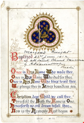
Baptismal certificate for Margaret Knight
https://search.heritageburnaby.ca/link/museumdescription15315
- Repository
- Burnaby Village Museum
- Date
- 1912
- Collection/Fonds
- Margaret Norton fonds
- Description Level
- Item
- Physical Description
- 1 p.
- Scope and Content
- Item consists of a certificate authenticating Margaret Knight's baptism in All Saints Church, Vancouver, 23rd June 1912.
- Repository
- Burnaby Village Museum
- Collection/Fonds
- Margaret Norton fonds
- Description Level
- Item
- Physical Description
- 1 p.
- Scope and Content
- Item consists of a certificate authenticating Margaret Knight's baptism in All Saints Church, Vancouver, 23rd June 1912.
- Subjects
- Documentary Artifacts - Certificates
- Accession Code
- BV020.34.4
- Access Restriction
- No restrictions
- Reproduction Restriction
- May be restricted by third party rights
- Date
- 1912
- Media Type
- Textual Record
- Scan Resolution
- 600
- Scan Date
- March 22, 2021
- Scale
- 100
- Notes
- Title based on contents of item
- All Saints Anglican Church was located in Burnaby on Royal Oak Avenue
Images

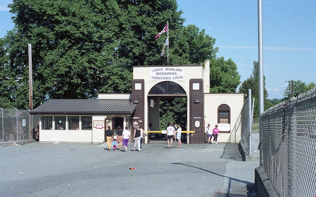
Entry gates to Oakalla
https://search.heritageburnaby.ca/link/museumdescription17836
- Repository
- Burnaby Village Museum
- Date
- 1991
- Collection/Fonds
- Oakalla Prison collection
- Description Level
- Item
- Physical Description
- 1 photograph : col. negative ; 35 mm
- Scope and Content
- Photograph of the main entry gates to the Lower Mainland Regional Correctional Centre - Oakalla Prison. Visitors are standing outside the gates during the Oakalla Prison farm Open House event that took place in 1991. The prison was located at 4700 Royal Oak Avenue (later 5220 Oakmount Crescent).
- Repository
- Burnaby Village Museum
- Collection/Fonds
- Oakalla Prison collection
- Description Level
- Item
- Physical Description
- 1 photograph : col. negative ; 35 mm
- Scope and Content
- Photograph of the main entry gates to the Lower Mainland Regional Correctional Centre - Oakalla Prison. Visitors are standing outside the gates during the Oakalla Prison farm Open House event that took place in 1991. The prison was located at 4700 Royal Oak Avenue (later 5220 Oakmount Crescent).
- Subjects
- Public Services - Correctional
- Geographic Access
- Oakmount Crescent
- Street Address
- 5220 Oakmount Crescent
- Accession Code
- BV991.45.620
- Access Restriction
- No restrictions
- Reproduction Restriction
- No known restrictions
- Date
- 1991
- Media Type
- Photograph
- Historic Neighbourhood
- Burnaby Lake (Historic Neighbourhood)
- Planning Study Area
- Oakalla Area
- Photographer
- Stevens, Colin
- Notes
- Title based on contents of photograph
- Photograph negative #1 from Roll 91-8
- 1 col. copy print accompanying
- Note in black ink on verso of accompanying copy print reads: "P91-8-1"
Images
Interview with Gail Yip May 9, 2005 - Track 2
https://search.heritageburnaby.ca/link/museumdescription4492
- Repository
- Burnaby Village Museum
- Date
- 1950s & 1960s (interview content), interviewed May 9, 2005
- Collection/Fonds
- Burnaby Village Museum fonds
- Description Level
- Item
- Physical Description
- 1 sound recording (mp3) (0:10:03 min)
- Scope and Content
- Track 2: This portion of the recording pertains to Gail’s organized activities, her best and worst childhood memories, recreation, shopping, her feeling about living in Burnaby and the changes she has observed. 0:00-3:18: Gail continues to talk about Brownies. She relates her worst childhood memor…
- Repository
- Burnaby Village Museum
- Collection/Fonds
- Burnaby Village Museum fonds
- Series
- Museum Oral Histories series
- Subseries
- Growing Up in Burnaby subseries
- Description Level
- Item
- Physical Description
- 1 sound recording (mp3) (0:10:03 min)
- Material Details
- Interviewer: Tom Gooden Interviewee: Gail Yip Date of interview: May 9, 2005 Total Number of Tracks: 2 Total length of all Tracks: 0:22:16
- Scope and Content
- Track 2: This portion of the recording pertains to Gail’s organized activities, her best and worst childhood memories, recreation, shopping, her feeling about living in Burnaby and the changes she has observed. 0:00-3:18: Gail continues to talk about Brownies. She relates her worst childhood memory, but can’t select a best. She describes how her activities were affected by living in the Marine Drive corridor, which was a difficult place to walk or cycle, or even cross the street. Gail mentions that her older sister encountered racial prejudice, but she can’t remember encountering any herself. 3:18-7:58: Gail discusses living in Burnaby, and the changes she has observed in the city. She describes the Kingsway corridor as busier and more congested now, but notes that there are improved opportunities for shopping . Gail recalls that her family did their grocery shopping at the Safeway at Royal Oak Avenue and Rumble St., and went to Woodward’s department store in New Westminster. She relates that although her family occasionally went to Chinatown in Vancouver, and that as a teenager she sometimes went to Vancouver to shop, she went to New Westminster more often, preferring the movie theatres there also. She notes that bus service on Marine Drive was infrequent, which affected her activities. Gail recalls that shopping days and hours were more restricted when she was a child. She describes how her family shopped by car, when her father was available to drive, until her mother began driving them later. 7:58-10:03: Gail shares her favourite things about living in Burnaby. She recalls being married at South Burnaby United Church, where she had gone to Sunday School, but not by a Chinese minister as she doesn’t speak Chinese.
- History
- Recording of an interview with Gail Yip recording by Tom Gooden on May 9, 2005. This recording was completed for an exhibit, Growing Up in Burnaby, for the Burnaby Village Museum. Major themes discussed are growing up in Burnaby in the 1950s and 60s.
- Creator
- Burnaby Village Museum
- Names
- Yip, Gail
- Accession Code
- BV017.45.4
- Access Restriction
- No restrictions
- Reproduction Restriction
- May be restricted by third party rights
- Date
- 1950s & 1960s (interview content), interviewed May 9, 2005
- Media Type
- Sound Recording
- Notes
- Title based on contents of item
Audio Tracks
Interview with Gail Yip May 9, 2005 - Track 2, 1950s & 1960s (interview content), interviewed May 9, 2005
Interview with Gail Yip May 9, 2005 - Track 2, 1950s & 1960s (interview content), interviewed May 9, 2005
https://search.heritageburnaby.ca/media/hpo/_Data/_BVM_Sound_Recordings/Oral_Histories/2017_0045_0004_002.mp3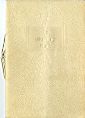
Marriage book for John Leonard Norton and Margaret Knight
https://search.heritageburnaby.ca/link/museumdescription15316
- Repository
- Burnaby Village Museum
- Date
- 27 Sep. 1947
- Collection/Fonds
- Margaret Norton fonds
- Description Level
- Item
- Physical Description
- 1 booklet
- Scope and Content
- Item consists of a twelve page marriage book that includes a certificate authenticating the marriage of John Leonard Norton to Margaret Knight at Vancouver Heights United Church on September 27, 1947 along with other details of the ceremony.
- Repository
- Burnaby Village Museum
- Collection/Fonds
- Margaret Norton fonds
- Description Level
- Item
- Physical Description
- 1 booklet
- Material Details
- textured card stock cover with six pages; printed both sides; folded in half and bound to cover with single cord at centre fold
- Scope and Content
- Item consists of a twelve page marriage book that includes a certificate authenticating the marriage of John Leonard Norton to Margaret Knight at Vancouver Heights United Church on September 27, 1947 along with other details of the ceremony.
- Subjects
- Documentary Artifacts - Certificates
- Accession Code
- BV020.34.5
- Access Restriction
- No restrictions
- Reproduction Restriction
- May be restricted by third party rights
- Date
- 27 Sep. 1947
- Media Type
- Textual Record
- Scan Resolution
- 600
- Scan Date
- March 22, 2021
- Scale
- 100
- Notes
- Title based on contents of item
- All Saints Anglican Church was located in Burnaby on Royal Oak Avenue
Images
