Narrow Results By
Subject
- Advertising Medium 1
- Advertising Medium - Business Cards 1
- Advertising Medium - Signs and Signboards 4
- Aerial Photographs 7
- Agriculture - Fruit and Berries 2
- Animals - Deer 1
- Armament - Munitions 1
- Building Components 3
- Buildings 1
- Buildings - Civic - Art Galleries 1
- Buildings - Civic - Libraries 1
- Buildings - Commercial 2
Creator
- Adams, John, 1926-1998 1
- Arranged and edited by Rhonda Ross and Alex W. Fraser 1
- Barrowclough, G.A. 1
- Barrowclough, George Alfred 1
- Bartel, Mario 4
- Battistoni, Peter 1
- Binks, James 1
- Blissett, Rebecca 1
- Burnaby, Robert, 1828-1878 1
- Burnaby Village Museum 3
- Canadian Broadcasting Corporation 1
- Carter, David 1
Subdivision of L.J. Ross in DL 86
https://search.heritageburnaby.ca/link/councilreport41175
- Repository
- City of Burnaby Archives
- Report ID
- 37925
- Meeting Date
- 30-Nov-1959
- Format
- Council - Manager's Report
- Manager's Report No.
- 48
- Item No.
- 8
- Collection/Fonds
- City Council and Office of the City Clerk fonds
- Repository
- City of Burnaby Archives
- Report ID
- 37925
- Meeting Date
- 30-Nov-1959
- Format
- Council - Manager's Report
- Manager's Report No.
- 48
- Item No.
- 8
- Collection/Fonds
- City Council and Office of the City Clerk fonds
Documents
Tender of N.S. Ross for Spreading Rock on Smith Ave.
https://search.heritageburnaby.ca/link/councilreport75045
- Repository
- City of Burnaby Archives
- Report ID
- 81496
- Meeting Date
- 2-May-1908
- Format
- Council - Mayor/Councillor/Staff Report
- Collection/Fonds
- City Council and Office of the City Clerk fonds
- Repository
- City of Burnaby Archives
- Report ID
- 81496
- Meeting Date
- 2-May-1908
- Format
- Council - Mayor/Councillor/Staff Report
- Collection/Fonds
- City Council and Office of the City Clerk fonds
Documents
Three Plank Sidewalk to be Laid on Ross Avenue
https://search.heritageburnaby.ca/link/councilreport76304
- Repository
- City of Burnaby Archives
- Report ID
- 76280
- Meeting Date
- 13-Nov-1911
- Format
- Council - Committee Report
- Collection/Fonds
- City Council and Office of the City Clerk fonds
- Repository
- City of Burnaby Archives
- Report ID
- 76280
- Meeting Date
- 13-Nov-1911
- Format
- Council - Committee Report
- Collection/Fonds
- City Council and Office of the City Clerk fonds
Documents

Mortimer-Lamb House
https://search.heritageburnaby.ca/link/landmark494
- Repository
- Burnaby Heritage Planning
- Description
- The Mortimer-Lamb House is a one and one half-storey, Arts and Crafts-style residence with a steeply pitched, side-gabled roof. The original cottage form has been enlarged with a later addition on the west side of the house. Located next to the Burnaby Lake Regional Park Wildlife Rescue Care Centre…
- Associated Dates
- c.1922
- Formal Recognition
- Community Heritage Register
- Other Names
- Harold & Katherine Mortimer-Lamb Residence
- Street View URL
- Google Maps Street View
- Repository
- Burnaby Heritage Planning
- Other Names
- Harold & Katherine Mortimer-Lamb Residence
- Geographic Access
- Glencarin Drive
- Associated Dates
- c.1922
- Formal Recognition
- Community Heritage Register
- Enactment Type
- Council Resolution
- Enactment Date
- 26/05/2003
- Description
- The Mortimer-Lamb House is a one and one half-storey, Arts and Crafts-style residence with a steeply pitched, side-gabled roof. The original cottage form has been enlarged with a later addition on the west side of the house. Located next to the Burnaby Lake Regional Park Wildlife Rescue Care Centre, the house has picturesque views of Burnaby Lake.
- Heritage Value
- Built circa 1922, the Mortimer-Lamb House is valued for its association with first owners, Harold Mortimer-Lamb (1872-1970), and his wife, Katherine Mary Mortimer-Lamb (1873-1939). Born in Leatherhead, Surrey, England, Harold Mortimer-Lamb immigrated to Canada in 1889. Seven years later in Vancouver, he married Katherine Mary Lindsay, a native of Winnipeg. Mortimer-Lamb was a key figure in the B.C. mining industry, serving as Secretary of the Mining Association of B.C. between 1900 and 1945, and also as the Secretary of the Canadian Institute of Mining and Metallurgy. In addition to his professional life, Mortimer-Lamb was a pioneer art photographer and was among Canada's leading art critics, and this house served as a central gathering place for renowned Canadian artists of the day. Mortimer-Lamb’s daughter, Molly Lamb Bobak (born 1922), became a renowned watercolourist, and was the only woman ever hired as an official Canadian war artist. The Mortimer-Lamb House is a significant example of the work of noted architect, Samuel Maclure (1860-1929) and his partner, Ross Lort (1889-1969). Maclure, who was a close friend of the Mortimer-Lamb family, was British Columbia's leading residential architect, and was renowned for his high quality designs for prominent citizens in both Vancouver and Victoria. Maclure was a leading exponent of the Art and Crafts design movement in B.C., and established a sophisticated local variation of residential architecture. The Mortimer-Lamb House was designed at the time when Maclure was in partnership with Ross Lort. In 1907, Lort began working for Maclure's firm as a draftsman, and by 1920 was in charge of Maclure's Vancouver office. Lort's architectural career spanned some sixty-years, and he designed some of the province's most familiar houses, apartments, institutions and places of worship. The Mortimer-Lamb House is also a significant local example of the Arts and Crafts style, and incorporates elements such as board-and-batten siding on the ground floor, shingled gables and leaded casement windows. It is a testament to the domestic architecture built outside of established suburbs during the post-First World War era, typically modest in scale and representative of middle-class residential ideals.
- Defining Elements
- Key elements that define the heritage character of the Mortimer-Lamb House include its: - treed setting with views of Burnaby Lake - residential form, scale and massing as expressed by its one and one-half storey height, rectangular plan and steeply pitched side-gabled roof - wood-frame construction - Arts and Crafts elements such as board-and-batten siding on the ground floor, cedar shingles in the gables and open soffits - original straight-leaded casement windows in single and multiple-assembly - internal red-brick chimney with corbelled cap
- Historic Neighbourhood
- Burnaby Lake (Historic Neighbourhood)
- Planning Study Area
- Burnaby Lake Area
- Organization
- Mining Association of B.C.
- G.F. and J. Galt Limited
- Architect
- Samuel Maclure
- Ross Lort
- Function
- Primary Historic--Single Dwelling
- Primary Current--Single Dwelling
- Community
- Burnaby Lake
- Cadastral Identifier
- P.I.D.002-977-788
- Boundaries
- The Mortimer-Lamb House is comprised of a single residential lot located at 5180 Glencairn Drive, Burnaby.
- Area
- 5652.78
- Contributing Resource
- Building
- Ownership
- Private
- Documentation
- City of Burnaby Planning and Building Department, Heritage Site Files
- Street Address
- 5180 Glencarin Drive
- Street View URL
- Google Maps Street View
Images


Barnet Neighbourhood
https://search.heritageburnaby.ca/link/landmark716
- Repository
- Burnaby Heritage Planning
- Associated Dates
- 1889-1904
- Heritage Value
- The North Pacific Lumber Company in Barnet was one of Burnaby's first industrial developments and one of the largest in the British Empire. Partners James MacLaren and Frank Ross built the mill in 1889 (activated in 1899) as a requirement for obtaining 84,000 acres of timber rights in northern BC. Due to the mill's isolation, the firm built homes for its employees with families and bunkhouses for the bachelors which separated Caucasian workers from Chinese and Sikh workers. Barnet became a distinct company town with its own general store, school, post office, community hall and telephone exchange.
- Historic Neighbourhood
- Barnet (Historic Neighbourhood)
- Planning Study Area
- Burnaby Mountain Area
Images


St. John the Divine Anglican Church
https://search.heritageburnaby.ca/link/landmark514
- Repository
- Burnaby Heritage Planning
- Description
- St. John the Divine Anglican Church is a landmark wood-frame Gothic Revival church, with Gothic windows and spire. It is located on Kingsway, one of Burnaby’s main commercial thoroughfares, near the SkyTrain transit line and across the street from Central Park.
- Associated Dates
- 1905
- Formal Recognition
- Community Heritage Register
- Street View URL
- Google Maps Street View
- Repository
- Burnaby Heritage Planning
- Geographic Access
- Kingsway
- Associated Dates
- 1905
- Formal Recognition
- Community Heritage Register
- Enactment Type
- Council Resolution
- Enactment Date
- 09/06/2003
- Description
- St. John the Divine Anglican Church is a landmark wood-frame Gothic Revival church, with Gothic windows and spire. It is located on Kingsway, one of Burnaby’s main commercial thoroughfares, near the SkyTrain transit line and across the street from Central Park.
- Heritage Value
- St. John the Divine Anglican Church is valued as a symbol of the traditions of early Burnaby pioneers and as the oldest surviving church building in the city. Established in 1899, St. John was the first church in the community and was located at a prominent intersection of the old Vancouver-Westminster Road (now Kingsway) and the British Columbia Electric Railway’s interurban station at Central Park. This prominent intersection of the road and rail developed as the town centre of the Central Park district. The first St. John church was destroyed by fire, and was rebuilt at the same location in 1904-05. This church is additionally significant for its association with prominent local architect Joseph Henry Bowman (1864-1943) who emigrated from England in 1888. Bowman was a member of the parish, and designed both the first church and its subsequent replacement. Bowman’s prolific career embraced many stylistic changes and technological advances, and this church is a surviving example of one of his rare religious commissions. The design of the new church's nave and vestry was based on the Gothic Revival style of Christ Church Anglican in Surrey, B.C., which had been the former church of St. John’s incumbent Rev. William Bell. Evolving over time as the congregation grew, the church received a number of early additions, and in 1953 was substantially renovated and enlarged through a new design by Vancouver architect Ross Lort. The original church nave was separated from the tower and turned to allow for a large addition. The congregation relocated to a new church in 1998, and at that time removed the church's memorial windows, leaving behind a number of the original art glass windows installed in the 1920s. The church building was renovated in 2004-05, and surviving original elements were retained and restored, including of the original church tower and interior chancel ceiling. A valued feature of the building is the original cast iron church bell that remains in the tower. It was purchased by the children of the congregation in 1912, and in 1924 was rededicated on Armistice Day as a memorial to Burnaby resident Lt. James Donald McRae Reid, who died in the First World War.
- Defining Elements
- Key elements that define the heritage character of St. John the Divine Anglican Church include its: - location on the north side of Kingsway, opposite Central Park - ecclesiastical form, scale and massing as expressed by the offset tower and tall, gabled roof - tower with its original horizontal wooden drop siding, bellcast square roof with octagonal drum above and bellcast octagonal spire - cedar shingle roof cladding - metal cross at peak of spire - Gothic Revival details such as: Gothic lancet windows with leaded stained glass panels; Gothic entrance door at the base of the tower; pointed-arch louvers in the tower; and exterior gable end scissor-trusses - interior features such as wooden scissor-trusses with diagonal fir tongue and groove panelling on the ceiling above, fir tongue-and-groove panelling on the wall of the nave, and original cedar and fir pews and altar rails - cast iron bell in tower
- Historic Neighbourhood
- Central Park (Historic Neighbourhood)
- Planning Study Area
- Garden Village Area
- Architect
- Joesph Henry Bowman
- Function
- Primary Historic--Place of Worship
- Primary Current--Place of Worship
- Community
- Burnaby
- Cadastral Identifier
- 003-398-871
- Boundaries
- St. John the Divine Anglican Church is comprised of a single institutional lot located at 3891 Kingway, Burnaby.
- Area
- 3486.66
- Contributing Resource
- Building
- Ownership
- Private
- Street Address
- 3891 Kingsway
- Street View URL
- Google Maps Street View
Images


Stowe Residence
https://search.heritageburnaby.ca/link/landmark642
- Repository
- Burnaby Heritage Planning
- Description
- Residential building.
- Associated Dates
- 1930
- Street View URL
- Google Maps Street View
- Repository
- Burnaby Heritage Planning
- Geographic Access
- Burris Street
- Associated Dates
- 1930
- Description
- Residential building.
- Heritage Value
- This charming home was built for George Norman Stowe (1885-1955) and his wife Lillian (née Ross) Stowe after they purchased this property from the Municipality of Burnaby in a Depression-era tax sale. George Stowe was a civil engineer with the Provincial Department of Public Works from 1905 until 1950. Inspired by the British Arts and Crafts movement, this stuccoed cottage is notable for its picturesque side gabled roof with sloped eaves, and a jerkin-headed dormer with half-timbering. Multi-paned casement windows are used throughout the house, adding to the picturesque effect. A verandah with a colonnade of pillars on the east side of the home overlooks a ravine.
- Locality
- Burnaby Lake
- Historic Neighbourhood
- Burnaby Lake (Historic Neighbourhood)
- Planning Study Area
- Morley-Buckingham Area
- Area
- 1963.96
- Contributing Resource
- Building
- Ownership
- Private
- Street Address
- 7484 Burris Street
- Street View URL
- Google Maps Street View
Images

The history of freemasonry in Canada from its introduction in 1749 embracing a general history of the craft and its origin, but more particularly a history of the craft in the province of Upper Canada, now Ontario, in the Dominion of Canada : compiled and written from official records and from mss. covering the period from 1749-1858, in the possession of the author, Volume 1
https://search.heritageburnaby.ca/link/museumlibrary2704
- Repository
- Burnaby Village Museum
- Collection
- Special Collection
- Material Type
- Book
- Accession Code
- HV974.60.1
- Call Number
- 366.10971 ROB v.1
- Place of Publication
- Toronto, Ont.
- Publisher
- The Hunter, Rose Company, Limited
- Publication Date
- 1899
- Physical Description
- xxi, 1196 p. : ill. (incl. ports.) maps (some folded) plans, facsims. (some folded) folded tables. ; 26 cm.
- Library Subject (LOC)
- Freemasons--History
- Secret societies--Canada
- Freemasonry
- Notes
- "Grand Lodge of Ancient Free and Accepted Masons of Canada" with the Arms of the Grand Lodge of Canada -- Front Cover
- "The edition of this work consists of two thousand sets. The number of this set is 29."
- Includes index.
- Author's given name and dates: Robertson, J. Ross (John Ross), 1841-1918.
The history of freemasonry in Canada from its introduction in 1749 embracing a general history of the craft and its origin, but more particularly a history of the craft in the province of Upper Canada, now Ontario, in the Dominion of Canada : compiled and written from official records and from mss. covering the period from 1749-1858, in the possession of the author, Volume 2
https://search.heritageburnaby.ca/link/museumlibrary2705
- Repository
- Burnaby Village Museum
- Collection
- Special Collection
- Material Type
- Book
- Accession Code
- HV974.60.2
- Call Number
- 366.10971 ROB v.2
- Place of Publication
- Toronto, Ont.
- Publisher
- The Hunter, Rose Company, Limited
- Publication Date
- 1899
- Physical Description
- xxiv, 979 p. : ill. (incl. ports.) maps (some folded) plans, facsims. (some folded) folded tables. ; 26 cm.
- Inscription
- "April 30 1874 / John Leslie St. Clair no 1353 R C Mitters Ont / H M 1895 Prince Ruperts Lodge N 13R M / Z 1883 1884 Prince Ruperts Rct 6 no 52 3R6 / Treasurers King Edward Preceptory / members it & SS Rite 32 April 8th 1887 / at it O M M S Khuram / Grand Masters Manitoba June 1899 June 1903 / Grand Z G C of Canada 1907 & 1908 / Semi Centennial held Toronto Jun 22 1908 / W M St Clair December 27 1878 to Dec 27th 1880" -- handwritten in ink on flyleaf.
- Library Subject (LOC)
- Freemasons--History
- Secret societies--Canada
- Freemasonry
- Notes
- "Grand Lodge of Ancient Free and Accepted Masons of Canada" with the Arms of the Grand Lodge of Canada -- Front Cover
- "The edition of this work consists of two thousand sets. The number of this set is 29."
- Includes index.
- Author's given name and dates: Robertson, J. Ross (John Ross), 1841-1918.
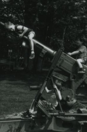
Boys playing on a large gun
https://search.heritageburnaby.ca/link/archivedescription38206
- Repository
- City of Burnaby Archives
- Date
- April 12, 1988 (date of original), copied 1991
- Collection/Fonds
- Burnaby Historical Society fonds
- Description Level
- Item
- Physical Description
- 1 photograph : b&w ; 4.6 x 3.0 cm print on contact sheet 20.3 x 26.6 cm
- Scope and Content
- Photograph of three boys, Morgan Ross, Matthew Owen and Jason Owen, playing on a gun in Confederation Park. This gun had movable parts, allowing park goers to operate it to some extent.
- Repository
- City of Burnaby Archives
- Date
- April 12, 1988 (date of original), copied 1991
- Collection/Fonds
- Burnaby Historical Society fonds
- Subseries
- Burnaby Image Bank subseries
- Physical Description
- 1 photograph : b&w ; 4.6 x 3.0 cm print on contact sheet 20.3 x 26.6 cm
- Description Level
- Item
- Record No.
- 370-793
- Access Restriction
- No restrictions
- Reproduction Restriction
- No restrictions
- Accession Number
- BHS1999-03
- Scope and Content
- Photograph of three boys, Morgan Ross, Matthew Owen and Jason Owen, playing on a gun in Confederation Park. This gun had movable parts, allowing park goers to operate it to some extent.
- Media Type
- Photograph
- Notes
- Title based on contents of photograph
- 1 b&w copy negative accompanying
- Copied from col. photograph
- Geographic Access
- Confederation Park
- Willingdon Avenue
- Street Address
- 250 Willingdon Avenue
- Historic Neighbourhood
- Capitol Hill (Historic Neighbourhood)
- Planning Study Area
- Capitol Hill Area
Images

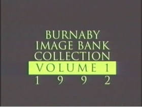
Burnaby's Photographic Family Album-Burnaby Image Bank Collection: Volume 1
https://search.heritageburnaby.ca/link/archivedescription64764
- Repository
- City of Burnaby Archives
- Date
- 1992
- Collection/Fonds
- Burnaby Historical Society fonds
- Description Level
- Item
- Physical Description
- 1 videocassette (1 hr., 56 min., 40 sec.) : b&w, col., sd.
- Scope and Content
- Item is a copy of "Burnaby's Photographic Family Album / Burnaby Image Bank Collection / Volume 1 / 1992" produced by the Simon Fraser University (SFU) Archives, and Archivist, Jim Ross in recognition of Burnaby’s Centennial. The video consists of 812 images from the Burnaby Image Bank which are i…
- Repository
- City of Burnaby Archives
- Date
- 1992
- Collection/Fonds
- Burnaby Historical Society fonds
- Subseries
- Burnaby Image Bank subseries
- Physical Description
- 1 videocassette (1 hr., 56 min., 40 sec.) : b&w, col., sd.
- Material Details
- Video Home System (VHS) tape
- Description Level
- Item
- Record No.
- 577-001
- Access Restriction
- No restrictions
- Reproduction Restriction
- May be restricted by third party rights
- Accession Number
- BHS2001-15
- Scope and Content
- Item is a copy of "Burnaby's Photographic Family Album / Burnaby Image Bank Collection / Volume 1 / 1992" produced by the Simon Fraser University (SFU) Archives, and Archivist, Jim Ross in recognition of Burnaby’s Centennial. The video consists of 812 images from the Burnaby Image Bank which are indexed by Communities, Neighbourhoods, Subjects and Names. The indexes are provided at both the beginning and end of the video with photographs dispersed in between. An introduction is provided by Simon Fraser University Archivist, Jim Ross. The video was made available for public purchase and viewing on Video Home System (VHS) format and distributed to each Burnaby school and branch of the Burnaby Public Library for information and research purposes.
- Media Type
- Moving Images
- Notes
- Transcribed title
Images
Video
Burnaby's Photographic Family Album-Burnaby Image Bank Collection: Volume 1, 1992
Burnaby's Photographic Family Album-Burnaby Image Bank Collection: Volume 1, 1992
https://search.heritageburnaby.ca/media/Hpo/_Data/_Archives_Moving_Images/_Unrestricted/577-001.m4v
Central Park Entrance
https://search.heritageburnaby.ca/link/archivedescription38507
- Repository
- City of Burnaby Archives
- Date
- 1914
- Collection/Fonds
- Burnaby Historical Society fonds
- Description Level
- Item
- Physical Description
- 1 photograph : b&w postcard ; 9 x 14 cm
- Scope and Content
- Photographic postcard of the entrance arch at Central Park. The postcard was sent to R.M. Harding of Everett, Washington and bears a New Westminster postmark and is dated August 6, 1922. The note written on the reverse of the card reads: " Dear Ross, This is were [sic] we made camp tonight. Wish…
- Repository
- City of Burnaby Archives
- Date
- 1914
- Collection/Fonds
- Burnaby Historical Society fonds
- Subseries
- Photographs subseries
- Physical Description
- 1 photograph : b&w postcard ; 9 x 14 cm
- Description Level
- Item
- Record No.
- 449-002
- Access Restriction
- No restrictions
- Reproduction Restriction
- No known restrictions
- Accession Number
- BHS2007-04
- Scope and Content
- Photographic postcard of the entrance arch at Central Park. The postcard was sent to R.M. Harding of Everett, Washington and bears a New Westminster postmark and is dated August 6, 1922. The note written on the reverse of the card reads: " Dear Ross, This is were [sic] we made camp tonight. Wish you were with us. We have had a dandy trip so far - but awfully dusty for about 14 miles from this side of the border line. Love, Eva."
- Names
- Harding, Ross M.
- Media Type
- Photograph
- Notes
- Title based on contents of photograph.
- Geographic Access
- Central Park
- Imperial Street
- Street Address
- 3883 Imperial Street
- Historic Neighbourhood
- Central Park (Historic Neighbourhood)
- Planning Study Area
- Maywood Area
Images

Charles Edgar 1772 - 1856
https://search.heritageburnaby.ca/link/archivedescription64450
- Repository
- City of Burnaby Archives
- Date
- 1998
- Collection/Fonds
- Burnaby Historical Society fonds
- Description Level
- Item
- Physical Description
- 1 book (soft-cover)
- Scope and Content
- Item is a soft-cover, coil-bound book on the history of "Charles Edgar / 1772 -1856 / Lancaster Township / Glengarry County / and / His Descendants 1772 - 1998 (in part)" arranged and edited by Rhonda Ross and Alex W. Fraser. Included on page 267 is an article written by Jim Wolf on the Edgar House…
- Repository
- City of Burnaby Archives
- Date
- 1998
- Collection/Fonds
- Burnaby Historical Society fonds
- Subseries
- Ephemera subseries
- Physical Description
- 1 book (soft-cover)
- Description Level
- Item
- Record No.
- MSS111-001
- Accession Number
- BHS2004-9
- Scope and Content
- Item is a soft-cover, coil-bound book on the history of "Charles Edgar / 1772 -1856 / Lancaster Township / Glengarry County / and / His Descendants 1772 - 1998 (in part)" arranged and edited by Rhonda Ross and Alex W. Fraser. Included on page 267 is an article written by Jim Wolf on the Edgar House; a heritage mansion built in 1912 on Deer Lake's South Shore.
- Media Type
- Textual Record
- Responsibility
- Arranged and edited by Rhonda Ross and Alex W. Fraser
- Notes
- Transcribed title
![Division II at West Burnaby School, [1906 or 1907] thumbnail](/media/hpo/_Data/_Archives_Images/_Unrestricted/001/034-002.jpg?width=280)
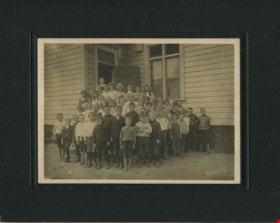
Division II at West Burnaby School
https://search.heritageburnaby.ca/link/archivedescription34520
- Repository
- City of Burnaby Archives
- Date
- [1906 or 1907]
- Collection/Fonds
- Burnaby Historical Society fonds
- Description Level
- Item
- Physical Description
- 1 photograph : b&w postcard ; 7.5 x 13 cm + 1 p.
- Scope and Content
- Photographic postcard of Division II at West Burnaby School (later renamed Kingsway West School) sitting and standing outside. Standing in the back row third from the left is Lillian Bond, beside her is [first name unknown] Barber, Eva Coburne, Mabel Ralph, [first name unknown] Bramble, George Robe…
- Repository
- City of Burnaby Archives
- Date
- [1906 or 1907]
- Collection/Fonds
- Burnaby Historical Society fonds
- Subseries
- Elsie B. Wilson subseries
- Physical Description
- 1 photograph : b&w postcard ; 7.5 x 13 cm + 1 p.
- Description Level
- Item
- Record No.
- 034-002
- Access Restriction
- No restrictions
- Reproduction Restriction
- No known restrictions
- Accession Number
- BHS2007-04
- Scope and Content
- Photographic postcard of Division II at West Burnaby School (later renamed Kingsway West School) sitting and standing outside. Standing in the back row third from the left is Lillian Bond, beside her is [first name unknown] Barber, Eva Coburne, Mabel Ralph, [first name unknown] Bramble, George Robertson, Mabel Rowlinson, unidentified, Georgina Bell, Bright Robertson and Fred Bond. Fourth from the left in the second row is Glen McMaster, sixth is Lois Rumble (later Wilson), beside her is Margaret Creamer, Gladys Bisset, Amy Sandell, unidentified, Elgin Robertson, unidentified and Bill Smith. Sitting in the front row, third from the left is Goldie Ralph, beside her is Edith Marten, unidentified, Jessie Robertson, [first name unknown] McMaster, Grace Marten, Elsie Wilson, Beatrice Barber, Dora Barber, Jean Ross and Dolly Smith. John Robertson is sitting on the ground, on the far left and Miss Annie Theresa Forrest is standing on the far left behind her students (next to her is a bicycle).
- Names
- Barber, Dora
- Bell, Georgina
- Bisset, Gladys
- Bond, Fred
- Bond, Lillian
- Coburne, Eva
- Creamer, Margaret
- Forrest, Annie Theresa
- Marten, Edith
- Marten, Grace
- McMaster, Glen
- Ralph, Goldie
- Ralph, Mabel
- Robertson, Bright
- Robertson, Elgin
- Robertson, George
- Robertson, Jessie
- Robertson, John
- Ross, Jean
- Rowlinson, Mabel
- Wilson, Lois Rumble
- Sandell, Amy
- Smith, Bill
- Smith, Dolly
- Wilson, Elsie
- Kingsway West School
- Media Type
- Photograph
- Photographer
- Barrowclough, G.A.
- Notes
- Title based on contents of photograph
- Printed by photographer on recto of photograph: "2nd Div. West Burnaby School / Barrowclough Cards"
- 1 page accompanying lists the individuals in the photograph as: "Back row, l to r: 3rd, Lillian Bond; 4th, [first name unknown] Barber; 5th, Eva Coburne; 6th, Mabel Ralph; 7th, [first name unknown] Bramble; 8th, George Robertson; 10th, Mabel Rowlinson; 12th, Georgina Bell; 13th Bright Robertson; and 14th, Fred Bond. Second row, l to r: 4th, Glen McMaster; 6th, Lois Rumble; 7th, Margaret Creamer; 8th, Gladys Bisset; 9th, Amy Sandell; 11th, Elgin Robertson; and 13th, Bill Smith. First row, l to r: 3rd, Goldie Ralph; 4th, Edith Marten; 6th, Jessie Robertson; 7th, [first name unknown] McMaster; 8th, Grace Marten; 9th, Elsie Wilson; 10th, Beatrice Barber; 11th, Dora Barber; 12th, Jean Ross; and 13th, Dolly Smith. Seated on ground, left to right: 1st, John Robertson."
- Geographic Access
- Kingsway
- Street Address
- 4800 Kingsway
- Historic Neighbourhood
- Central Park (Historic Neighbourhood)
- Planning Study Area
- Maywood Area
Images
![Division II at West Burnaby School, [1906 or 1907] thumbnail](/media/hpo/_Data/_Archives_Images/_Unrestricted/001/034-002.jpg)
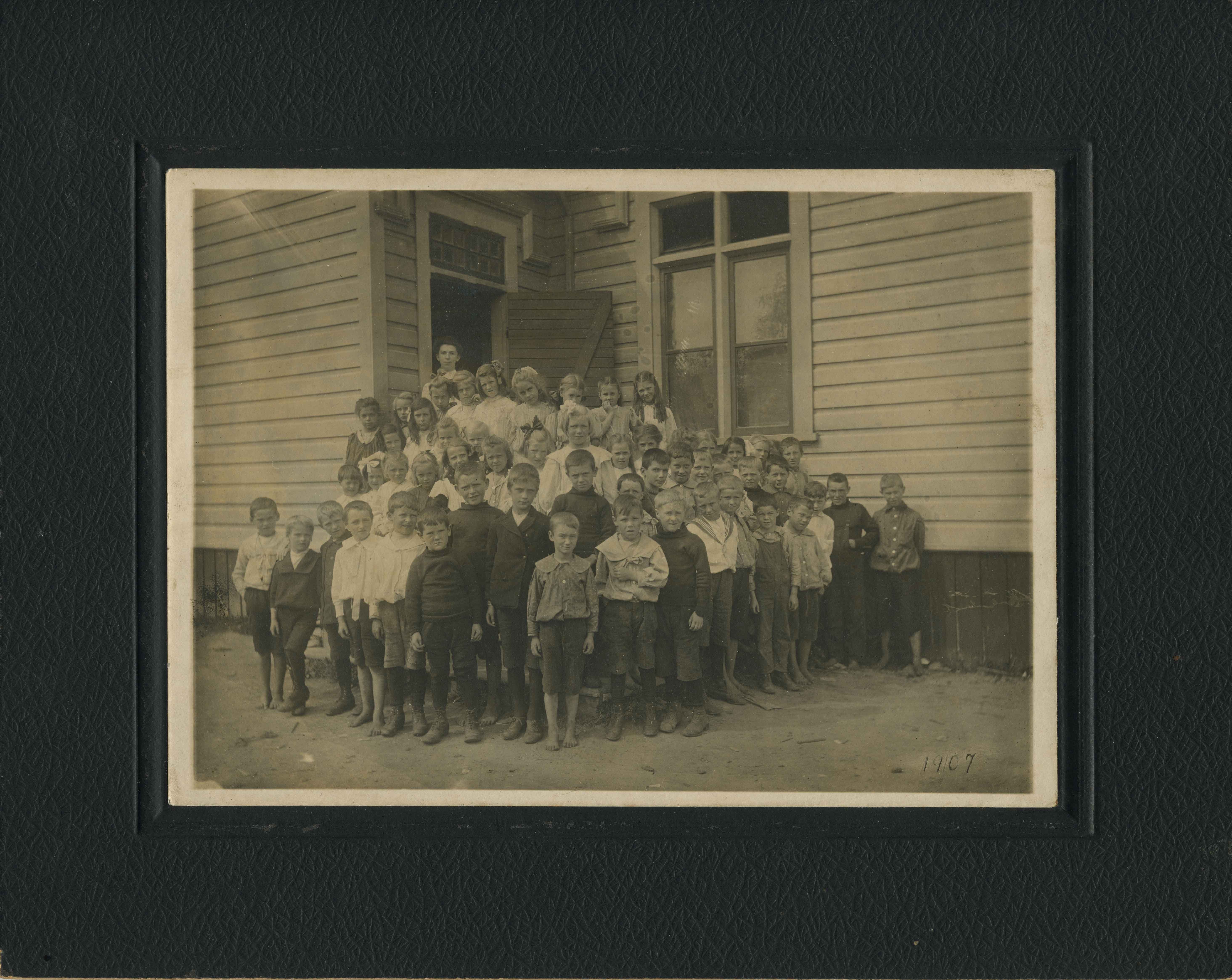
West Burnaby School Class
https://search.heritageburnaby.ca/link/archivedescription34519
- Repository
- City of Burnaby Archives
- Date
- 1904
- Collection/Fonds
- Burnaby Historical Society fonds
- Description Level
- Item
- Physical Description
- 1 photograph : b&w ; 12.8 x 17.8 cm mounted on cardboard 20.0 x 25.0 cm
- Scope and Content
- Photograph of a West Burnaby School (later renamed Kingsway West School) class standing outside of the school. Identified, back row, left to right: [unidentified], Georgina Bell, [first name unknown] Creamer, Gladys Bisset, Bernadette McNeil, Elsie Wilson, and Mabel Rowlinson. 2nd row, 5th from le…
- Repository
- City of Burnaby Archives
- Date
- 1904
- Collection/Fonds
- Burnaby Historical Society fonds
- Subseries
- Elsie B. Wilson subseries
- Physical Description
- 1 photograph : b&w ; 12.8 x 17.8 cm mounted on cardboard 20.0 x 25.0 cm
- Description Level
- Item
- Record No.
- 034-001
- Access Restriction
- No restrictions
- Reproduction Restriction
- No known restrictions
- Accession Number
- BHS2007-04
- Scope and Content
- Photograph of a West Burnaby School (later renamed Kingsway West School) class standing outside of the school. Identified, back row, left to right: [unidentified], Georgina Bell, [first name unknown] Creamer, Gladys Bisset, Bernadette McNeil, Elsie Wilson, and Mabel Rowlinson. 2nd row, 5th from left: Edith Marten. 3rd row, left to right: [first name unknown] McMaster, [unidentified], Jean Ross, [unidentified], Goldie Ralph, Mabel Ralph, Grace Marten, [3 unidentified children], Lois Rumble (later Wilson), [unidentified], and George Robertson. From row, left to right, starting at 7th child: Wilson Bailey, [first name unknown] Bond, [2 unidentified children], Bill Smith, Elgin Robertson, [2 unidentified children], Gordon Bailey, [2 unidentified children], [first name unknown] Bramble. The teacher, standing at the back left, is Miss Annie Theresa Forrest.
- Subjects
- Occupations - Teachers
- Names
- Bailey, Gordon
- Bailey, Wilson
- Bell, Georgina
- Bisset, Gladys
- Forrest, Annie Theresa
- Marten, Edith
- Marten, Grace
- McNeil, Bernadette
- Ralph, Mabel
- Robertson, Elgin
- Robertson, George
- Ross, Jean
- Rowlinson, Mabel
- Wilson, Lois Rumble
- Smith, Bill
- Kingsway West School
- Wilson, Elsie
- Media Type
- Photograph
- Notes
- Title based on contents of photograph
- Geographic Access
- Kingsway
- Street Address
- 4800 Kingsway
- Historic Neighbourhood
- Central Park (Historic Neighbourhood)
- Planning Study Area
- Maywood Area
Images

Windsor Street School class
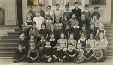
https://search.heritageburnaby.ca/link/archivedescription38407
- Repository
- City of Burnaby Archives
- Date
- November 17, 1939
- Collection/Fonds
- Burnaby Historical Society fonds
- Description Level
- Item
- Physical Description
- 1 photograph : b&w ; 11 x 17.5 cm
- Scope and Content
- Photograph of students from Windsor Street School on the steps of the building. Some of the students have been identified as follows: First row (l to r): Norman Jebson, Ron Decker, Ross Hepburn, unidentified, unidentified, unidentified, unidentified, George Decker. Second row: unidentified, uniden…
- Repository
- City of Burnaby Archives
- Date
- November 17, 1939
- Collection/Fonds
- Burnaby Historical Society fonds
- Subseries
- Ettinger family subseries
- Physical Description
- 1 photograph : b&w ; 11 x 17.5 cm
- Description Level
- Item
- Record No.
- 428-005
- Access Restriction
- No restrictions
- Reproduction Restriction
- No known restrictions
- Accession Number
- BHS2002-03
- Scope and Content
- Photograph of students from Windsor Street School on the steps of the building. Some of the students have been identified as follows: First row (l to r): Norman Jebson, Ron Decker, Ross Hepburn, unidentified, unidentified, unidentified, unidentified, George Decker. Second row: unidentified, unidentified, Ruth Weston, Bev Kidd, unidentified, A. Loftsgard, unidentified, B. Lockwood, unidentified. Third row: unidentified, unidentified, unidentified, D. Ettinger, unidentified, unidentified, unidentified, J. Penzer, unidentified, M. Farband. Fourth row: M. Lewis, unidentified, unidentified, A. Stanley, R. Strawson, unidentified, unidentified, unidentified. Fifth row: (1st) J. Allen, N. Cain (the rest are unidentified).
- Names
- Jebson, Norman
- Decker, Ron
- Hepburn, Ross
- Decker, George
- Weston, Ruth
- Kidd, Bev
- Loftsgard, A.
- Lockwood, B.
- Ettinger, D.
- Penzer, J.
- Farband, M.
- Lewis, M.
- Stanley, A.
- Strawson, R.
- Allen, J.
- Cain, N.
- Windsor Street School
- Media Type
- Photograph
- Notes
- Title based on contents of photograph
- Note on verso of photograph reads: "Windsor St School Nov 17/39"
- Geographic Access
- Imperial Street
- Street Address
- 6166 Imperial Street
- Historic Neighbourhood
- Edmonds (Historic Neighbourhood)
- Planning Study Area
- Windsor Area
Images

A country girl : a new and original musical play
https://search.heritageburnaby.ca/link/museumlibrary4922
- Repository
- Burnaby Village Museum
- Author
- Tanner, James T.
- Edition
- New ed.
- Publication Date
- c1904
- Call Number
- 789 TAN
- Repository
- Burnaby Village Museum
- Collection
- Special Collection
- Material Type
- Book
- Accession Code
- BV997.34.9
- Call Number
- 789 TAN
- Edition
- New ed.
- Author
- Tanner, James T.
- Contributor
- Ross, Adrian, 1859-1933
- Monckton, Lionel, 1861-1924
- Rubens, Paul A. (Paul Alfred), 1875-1917
- Greenbank, Percy, 1878-1968
- Place of Publication
- London
- Publisher
- Chappell & Co., Ltd.
- Publication Date
- c1904
- Printer
- Henderson and Spalding, Marylebone Press
- Physical Description
- 212 p. : 28 cm.
- Inscription
- "E. B. Wilson" [Handwritten twice in pencil on title page]
- Library Subject (LOC)
- Musical revues, comedies, etc.
- Musical plays--Vocal scores
- Musical plays
- Music
- Subjects
- Music
- Names
- Wilson, Elsie
- Object History
- Elsie Wilson - The material in the donation is from her estate. Miss Wilson was a Burnaby resident and music teacher. The brass plaque was on her fathers home "Penrith Castle" on Blenheim St. in Burnaby
- Notes
- "By James T. Tanner. Lyrics by Adrian Ross. Music by Lionel Monckton. Additional lyrics and numbers by Paul A. Rubens. Additional lyrics by Percy Greenbank" -- Title page
- Contributor's full name and dates: Rubens, Paul A. (Paul Alfred), 1875-1917
Images


Baxter's Market
https://search.heritageburnaby.ca/link/archivedescription79103
- Repository
- City of Burnaby Archives
- Date
- September 10, 1976
- Collection/Fonds
- Burnaby Public Library Contemporary Visual Archive Project
- Description Level
- Item
- Physical Description
- 1 photograph : b&w ; 11 x 16 cm mounted on cardboard
- Scope and Content
- Photograph shows Baxter's Market at 7658 Royal Oak Avenue near Rumble Street.
- Repository
- City of Burnaby Archives
- Date
- September 10, 1976
- Collection/Fonds
- Burnaby Public Library Contemporary Visual Archive Project
- Physical Description
- 1 photograph : b&w ; 11 x 16 cm mounted on cardboard
- Description Level
- Item
- Record No.
- 556-154
- Access Restriction
- No restrictions
- Reproduction Restriction
- Reproduce for fair dealing purposes only
- Accession Number
- 2013-13
- Scope and Content
- Photograph shows Baxter's Market at 7658 Royal Oak Avenue near Rumble Street.
- Names
- Baxter's Market
- Media Type
- Photograph
- Photographer
- Ross, Martha
- Notes
- Scope note taken directly from BPL photograph description.
- 1 b&w copy negative : 10 x 12.5 cm accompanying
- Geographic Access
- Royal Oak Avenue
- Rumble Street
- Street Address
- 7658 Royal Oak Avenue
- Historic Neighbourhood
- Alta-Vista (Historic Neighbourhood)
- Planning Study Area
- Clinton-Glenwood Area
Images


BC Hydro Railway Crossing
https://search.heritageburnaby.ca/link/archivedescription79487
- Repository
- City of Burnaby Archives
- Date
- September 22, 1976
- Collection/Fonds
- Burnaby Public Library Contemporary Visual Archive Project
- Description Level
- Item
- Physical Description
- 1 photograph : b&w ; 11 x 16 cm mounted on cardboard
- Scope and Content
- Photograph shows BC Hydro railroad tracks and crossing near Beresford Street and Griffiths Avenue.
- Repository
- City of Burnaby Archives
- Date
- September 22, 1976
- Collection/Fonds
- Burnaby Public Library Contemporary Visual Archive Project
- Physical Description
- 1 photograph : b&w ; 11 x 16 cm mounted on cardboard
- Description Level
- Item
- Record No.
- 556-319
- Access Restriction
- No restrictions
- Reproduction Restriction
- Reproduce for fair dealing purposes only
- Accession Number
- 2013-13
- Scope and Content
- Photograph shows BC Hydro railroad tracks and crossing near Beresford Street and Griffiths Avenue.
- Media Type
- Photograph
- Photographer
- Ross, Martha
- Notes
- Scope note taken directly from BPL photograph description.
- 1 b&w copy negative : 10 x 12.5 cm accompanying
- Historic Neighbourhood
- Edmonds (Historic Neighbourhood)
- Planning Study Area
- Stride Avenue Area
Images

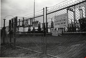
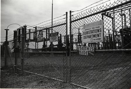
BC Hydro Substation
https://search.heritageburnaby.ca/link/archivedescription79356
- Repository
- City of Burnaby Archives
- Date
- September 22, 1976
- Collection/Fonds
- Burnaby Public Library Contemporary Visual Archive Project
- Description Level
- Item
- Physical Description
- 1 photograph : b&w ; 11 x 16 cm mounted on cardboard
- Scope and Content
- Photograph shows a BC Hydro substation located in Powerhouse Park near Beresford Street and Griffiths Avenue.
- Repository
- City of Burnaby Archives
- Date
- September 22, 1976
- Collection/Fonds
- Burnaby Public Library Contemporary Visual Archive Project
- Physical Description
- 1 photograph : b&w ; 11 x 16 cm mounted on cardboard
- Description Level
- Item
- Record No.
- 556-263
- Access Restriction
- No restrictions
- Reproduction Restriction
- Reproduce for fair dealing purposes only
- Accession Number
- 2013-13
- Scope and Content
- Photograph shows a BC Hydro substation located in Powerhouse Park near Beresford Street and Griffiths Avenue.
- Media Type
- Photograph
- Photographer
- Ross, Martha
- Notes
- Scope note taken directly from BPL photograph description.
- 1 b&w copy negative : 10 x 12.5 cm accompanying
- Geographic Access
- Griffiths Avenue
- Beresford Street
- Street Address
- 6970 Beresford Street
- Historic Neighbourhood
- Edmonds (Historic Neighbourhood)
- Planning Study Area
- Stride Avenue Area
Images