Narrow Results By
Subject
- Agricultural Tools and Equipment 1
- Agriculture - Fruit and Berries 2
- Animals - Dogs 1
- Buildings 1
- Buildings - Commercial - Stores 1
- Buildings Components - Fireplaces 1
- Buildings - Religious - Churches 1
- Buildings - Residential - Houses 3
- Buildings - Schools 2
- Celebrations - Jubilee 1
- Ceremonies - Weddings 1
- Construction - Road Construction 1
![Interior of the Patterson house, [189-?] (date of original), copied 1977 thumbnail](/media/hpo/_Data/_BVM_Images/1977/1977_0099_0022_001.jpg?width=280)
Interior of the Patterson house
https://search.heritageburnaby.ca/link/museumdescription580
- Repository
- Burnaby Village Museum
- Date
- [189-?] (date of original), copied 1977
- Collection/Fonds
- Burnaby Village Museum Photograph collection
- Description Level
- Item
- Physical Description
- 1 photograph : b&w ; 20.2 x 25.2 cm print
- Scope and Content
- Photograph of a house identified by accession register, catalogue record and inscription as the Patterson house, possibly built in 1890s. This house was located either on Patterson Street (where the family first lived in Burnaby) or Edmonds Street (where they later moved to). The photograph is ta…
- Repository
- Burnaby Village Museum
- Collection/Fonds
- Burnaby Village Museum Photograph collection
- Description Level
- Item
- Physical Description
- 1 photograph : b&w ; 20.2 x 25.2 cm print
- Scope and Content
- Photograph of a house identified by accession register, catalogue record and inscription as the Patterson house, possibly built in 1890s. This house was located either on Patterson Street (where the family first lived in Burnaby) or Edmonds Street (where they later moved to). The photograph is taken from a living room, looking towards a reading room. The living room has a fireplace with a mantle decorated with framed photographs. Through a wide doorway is shown a reading room with long drapes over the window, a piano, and a chair with an antimacassar. An annotation on the back of the photo reads: "Interior of Pateron [sic] home. / Located on Edmonds or Pateron [sic] St. ? / Built 1890's."
- Accession Code
- HV977.99.22
- Access Restriction
- No restrictions
- Reproduction Restriction
- May be restricted by third party rights
- Date
- [189-?] (date of original), copied 1977
- Media Type
- Photograph
- Scan Resolution
- 600
- Scan Date
- 2023-07-11
- Notes
- Title based on contents of photograph
Images
![Interior of the Patterson house, [189-?] (date of original), copied 1977 thumbnail](/media/hpo/_Data/_BVM_Images/1977/1977_0099_0022_001.jpg)

Murdock and Lillian McMurray interview November 17, 1975 - Track 1
https://search.heritageburnaby.ca/link/oralhistory243
- Repository
- City of Burnaby Archives
- Date Range
- 1892-1911
- Length
- 0:09:58
- Summary
- This portion of the recording pertains to Murdock McMurray's memories of the work that he and his brother did on the roadways; Canada Way, Kingsway. He discusses helping out at the Hatt-Cook residence as a boy as well as the tram system of the time. Lillian (Wray) McMurray is heard helping her husb…
- Repository
- City of Burnaby Archives
- Summary
- This portion of the recording pertains to Murdock McMurray's memories of the work that he and his brother did on the roadways; Canada Way, Kingsway. He discusses helping out at the Hatt-Cook residence as a boy as well as the tram system of the time. Lillian (Wray) McMurray is heard helping her husband with these descriptions.
- Date Range
- 1892-1911
- Photo Info
- Emerson Doran (left) and Murdoch McMurray, 1917. Item no. 229-004
- Length
- 0:09:58
- Subjects
- Construction - Road Construction
- Historic Neighbourhood
- Edmonds (Historic Neighbourhood)
- Interviewer
- McGeachie, Doreen “Pixie”
- Interview Date
- November 17, 1975
- Scope and Content
- Recording is of an interview with Murdock McMurray and his wife Lillian (Wray) McMurray conducted by Pixie McGeachie on November 17, 1975. Major themes discussed are: Burnaby's development, the Wray Shoe store and Murdock McMurray's cordwood delivery business.
- Biographical Notes
- Murdock McMurray was born in Vancouver in 1892 to Wilhelmina May and Robert William McMurray. Other children in the family included older siblings John “Jack” and Margaret Lillian, younger siblings Minnie May born May 4, 1895 and Hampton born June 8, 1902. Murdock’s father Robert worked for the Canadian Pacific Railway (CPR) but retired shortly after moving his family to Burnaby in 1906. He bought six acres of land of what had been previously the Gilley Ranch, the base of operations for Gilley Bros. Ltd. at 2519 Windsor Street (later renumbered and renamed to the 6400 block Imperial Street). Murdock McMurray quit school early to apprentice as a printer. By sixteen he had left the trade and gone into partnership with his older brother Jack. With a team of horses, harness and a wagon, the brothers helped to macadamize roads, haul building supplies for new homes, deliver cord wood for heating, clear land and excavate basements. When Jack McMurray set off to serve overseas during World War I as a driver in the engineer corps, Murdock bought his team of horses and continued working, mainly in the Deer Lake district. In 1916 Murdoch McMurray partnered with Emerson Doran, nephew of the owner of Doran's Mill to buy Edmonds Coal and Wood fuel yard. As everything was geared towards the war effort, Murdock and Emerson soon ran out of work and had to sell the business. Murdock sold off his horses and equipment and went to work at the ship yard on Pitt River. By 1919 Jack McMurray had returned home from overseas and was working as a fireman at the Shull Lumber and Shingle Mill on the Fraser River. In 1921, he and Murdock teamed up with Emerson Doran and repurchased the Edmonds Coal and Wood fuel yard which they ran together until 1947. Murdock McMurray married Lillian Wray on September 17, 1925. Lillian was the daughter of Mr. and Mrs. Edward Wray, who came to settle in the Jubilee area of Burnaby in 1919. The family lived on Dow Road and Edward Wray operated Jubilee Shoe Store and Post Office. He was known throughout the district as "Wray - The Shoe Man." Mrs. Wray died in 1957 at the age of eight-six and Edward Wray died January 14, 1967 at age of ninety-three. Murdock and Lillian lived at Inverness Street (now Arcola) and raised three children together, Bob, Jack and Bessie. Murdock McMurray died in New Westminster on April 28, 1985 at the age of ninety-two. Lillian Ethel (Wray) McMurray died in Burnaby on February 28, 1986 at the age of eighty-seven.
- Total Tracks
- 7
- Total Length
- 0:58:55
- Interviewee Name
- McMurray, Lillian Wray
- McMurray, Murdoch
- Interviewer Bio
- Doreen "Pixie" (Johnson) McGeachie was a resident of Burnaby for over sixty years. Pixie married John Aloysius "Jack" McGeachie and raised their children Kathi (Dunlop) and David McGeachie in the house the couple built themselves in 1947. Pixie served as the editor for the Burnaby Examiner newspaper and wrote a column entitled "Burnaby History" for The News. In 1974 she authored her first book titled "Bygones of Burnaby" which was one of the first to develop anecdotal stories about pioneer life in Burnaby. She authored "Burnaby - A Proud Century" in 1992 and in 2002 she wrote a biography of the city's namesake in the book "Land of Promise: Robert Burnaby's letters from Colonial B.C." She also contributed many hours of volunteering; helping to establish Burnaby's first museum Heritage Village in 1971, serving as President of the Burnaby Historical Society from 1991-1993. She served a six year term on Burnaby's Heritage Commission leading the charge to preserve many historic sites throughout the city, and during her twenty years as the Community Archives volunteer archivist for the historical society, she succeeded in gathering thousands of rare and valuable historic photographs and documents which now forms the core of the photograph collection on the Heritage Burnaby website (as these items were donated by the Society to the City Archives in 2007). The City of Burnaby awarded Pixie McGeachie the Kushiro Cup as Citizen of the year in 2002. In 2006 she received a Heritage BC project award for leading the Friends of Interurban 1223 project, and in 2008 Heritage BC recognised her again by presenting her with the Ruby Nobb Award. John Aloysius "Jack" McGeachie died October 12, 1981 at the age of sixty-seven. Doreen "Pixie" (Johnson) McGeachie died August 14, 2010 at the age of eighty-nine. On 24 September, 2011, the City of Burnaby dedicated the reading at the City Archives in honour of Pixie and formally named it the Pixie McGeachie Reading Room in recognition of her years of service to the community.
- Collection/Fonds
- Burnaby Historical Society fonds
- Subseries
- Oral history subseries
- Media Type
- Sound Recording
- Web Notes
- Interview was digitized in 2010 allowing it to be accessible on Heritage Burnaby. The digitization project was initiated by the Community Heritage Commission with support from City of Burnaby Council and the BC History Digitization Program of the Irving K. Barber Learning Centre, University of British Columbia. It was recognized by the Heritage Society of BC with an award in 2012.
Images

Audio Tracks
Track one of recording of interview with Lillian and Murdock McMurray
Track one of recording of interview with Lillian and Murdock McMurray
https://search.heritageburnaby.ca/media/hpo/_Data/_Archives_Oral_Histories/_Unrestricted/MSS137-010/MSS137-010_Track_1.mp3![Central Park siding of Westminster and Vancouver Tramway Co., [between 1891 and 1894] thumbnail](/media/hpo/_Data/_BVM_Images/2021/2021_0029_0001_001.jpg?width=280)
Central Park siding of Westminster and Vancouver Tramway Co.
https://search.heritageburnaby.ca/link/museumdescription17430
- Repository
- Burnaby Village Museum
- Date
- [between 1891 and 1894]
- Collection/Fonds
- Burnaby Village Museum Photograph collection
- Description Level
- Item
- Physical Description
- 1 photograph : b&w albumen print on card ; 20 x 25 cm
- Scope and Content
- Photograph of two streetcars at the Central Park siding of Westminster and Vancouver Tramway Co. Conductors, engineers and riders are posing with the streetcars. The fronts of the streetcars include painted signage reading "12" and "13" and the sides of the streetcars read "WESTMINSTER AND VANCOUVE…
- Repository
- Burnaby Village Museum
- Collection/Fonds
- Burnaby Village Museum Photograph collection
- Description Level
- Item
- Physical Description
- 1 photograph : b&w albumen print on card ; 20 x 25 cm
- Scope and Content
- Photograph of two streetcars at the Central Park siding of Westminster and Vancouver Tramway Co. Conductors, engineers and riders are posing with the streetcars. The fronts of the streetcars include painted signage reading "12" and "13" and the sides of the streetcars read "WESTMINSTER AND VANCOUVER TRAMWAY CO. LTD.".
- History
- Photographers Richard H. Trueman and Norman Caple operated out of Vancouver between 1891 and 1894. The photographers worked between Winnipeg and the west coast of Canada specializing in mountain and railway views, ranch scenes and Indigenous peoples. In 1890, two companies started building electric rail; the Westminster and Vancouver Tramway Co., which undertook the ambitious project of building the first real interurban line from New Westminster to Vancouver, and the Westminster Street Railway. By April 20, 1891, both companies merged to form the Westminster and Vancouver Tramway Company. Streetcar service began in June 1891, travelling on twelve miles of track between New Westminster and eastern Vancouver and running through Burnaby. The line was taken over by the B.C. Electric Railway Company in 1897 until the line was closed in October 1953.
- Accession Code
- BV021.29.1
- Access Restriction
- No restrictions
- Reproduction Restriction
- No known restrictions
- Date
- [between 1891 and 1894]
- Media Type
- Photograph
- Historic Neighbourhood
- Central Park (Historic Neighbourhood)
- Planning Study Area
- Maywood Area
- Scan Resolution
- 600
- Scan Date
- 2021-09-24
- Scale
- 100
- Photographer
- Trueman & Caple
- Notes
- Title taken from recto of photograph
- Inscription on recto of photograph reads: "1138_Central Parkk Sideing of Westminster and Vancouver Tramway Co. _Trueman and Caple. Photo. Vancouver B.C."
- Inscription in gold ink on board reads: "Trueman & Caple_Vancouver, B.C."
Images
![Central Park siding of Westminster and Vancouver Tramway Co., [between 1891 and 1894] thumbnail](/media/hpo/_Data/_BVM_Images/2021/2021_0029_0001_001.jpg)
![Family album, [between 1880 and 1900] thumbnail](/media/hpo/_Data/_Archives_Images/_Unrestricted/316/335-018-1.jpg?width=280)
Family album
https://search.heritageburnaby.ca/link/archivedescription37214
- Repository
- City of Burnaby Archives
- Date
- [between 1880 and 1900]
- Collection/Fonds
- Burnaby Historical Society fonds
- Description Level
- Item
- Physical Description
- 1 album (43 photographs : b&w ; 17 x 10 cm or smaller) ; 28 x 20 cm
- Scope and Content
- Photograph album consisting of photographs that are likely of members of the Johnson family. Photographs are primarily studio portraits of unidentified individuals, taken in various locations including: Helena, MT; Toronto; Montreal; New Westminster; Fredrikshald, Norway; and Chicago and Roseland, …
- Repository
- City of Burnaby Archives
- Date
- [between 1880 and 1900]
- Collection/Fonds
- Burnaby Historical Society fonds
- Subseries
- Andrew Johnson subseries
- Physical Description
- 1 album (43 photographs : b&w ; 17 x 10 cm or smaller) ; 28 x 20 cm
- Description Level
- Item
- Record No.
- 335-018
- Access Restriction
- No restrictions
- Reproduction Restriction
- No known restrictions
- Accession Number
- BHS1997-16
- Scope and Content
- Photograph album consisting of photographs that are likely of members of the Johnson family. Photographs are primarily studio portraits of unidentified individuals, taken in various locations including: Helena, MT; Toronto; Montreal; New Westminster; Fredrikshald, Norway; and Chicago and Roseland, IL. Photographs depict a group of maids, individuals, children alone or with their parents, and families.
- Subjects
- Documentary Artifacts - Portraits
- Media Type
- Photograph
- Notes
- Title based on contents of item
- Photographer's stamp on recto of 335-018-2 reads: "Wadds Bros / Vancouver & Nelson B.C."
- Photographer's stamp on verso of 335-018-3 reads: "J.H. Lemaitre & Co."
- Photographer's stamp on recto of 335-018-4 reads: "Gagen & Fraser / Toronto"
- Photographer's stamp on recto of 335-018-5 reads: "Perkins / Toronto"
- Photographer's stamp on recto of 335-018-6 reads: "Ahlborn / Chicago"
- Photographer's stamp on verso of 335-018-7 reads: "From the studio of J. B. Cook / ... Toronto"
- Photographer's stamp on recto of 335-018-8 reads: "Wadds Bros / Vancouver, B.C."
- Photographer's stamp on verso of 335-018-9 reads: "Eldridge Stanton / ... Toronto"
- Photographer's stamp on recto of 335-018-10 reads: "Dixon / ... Toronto"
- Photographer's stamp on recto of 335-018-11 reads: "Perkins / Toronto"
- Photographer's stamp on recto of 335-018-12 reads: "Wadds Bros / Vancouver, B.C."
- 335-018-12 is mounted on a sheet of cardboard
- Photographer's stamp on recto of 335-018-14 reads: "Perkins / Toronto"
- Photographer's stamp on verso of 335-018-15 reads: "Eldridge Stanton / ... Toronto"
- Photographer's stamp on recto of 335-018-16 reads: "J.T. Lambly, / ... Montreal"
- Photographer's stamp on recto of 335-018-17 reads: "Buchanan"
- Photographer's stamp on verso of 335-018-18 reads: "Topley" and features an elaborate design
- Photographer's stamp on verso of 335-018-19 reads: "Notman & Fraser" and "Toronto" and features an elaborate design
- Photographer's stamp on recto of 335-018-20 reads: "Farmer Brothers Photographers / Hamilton, Ont"
- Handwritten note on verso of 335-018-20 reads: "I wish you a Merry Christmas"
- Photographer's stamp on recto of 335-018-21 reads: "Perkins / Toronto"
- Photographer's stamp on recto of 335-018-22 reads: "Perkins / Toronto"
- Photographer's stamp on recto of 335-018-23 reads: "Dixon / ... Toronto"
- Photographer's stamp on recto of 335-018-24 reads: "Simpson Bros / ... Toronto"
- Caption on recto of 335-018-25 reads: "Toronto Photo Gallery"
- Photographer's stamp on recto of 335-018-26 reads: "Simpson Bros / ... Toronto"
- Photographer's stamp on recto of 335-018-28 reads: "H.R. Kiopman / Roseland, Ills."
- Photographer's stamp on recto of 335-018-29 reads: "J.G. Parks, Photo. Montreal"
- Photographer's stamp on verso of 335-018-30 reads: "J.G. Parks / ... Montreal"
- Photographer's stamp on recto of 335-018-32 reads: "S. J. Thompson, New Westminster B.C."
- Handwritten note onv erso of 335-018-32 reads: "Yours truly - J. M. McLeod" and "1/18/96"
- Photographer's stamp on verso of 335-018-33 reads: "From Burman's Photographic Rooms / ... Melbourne"
- Caption on recto of 335-018-35 reads: "Sunbeam"
- Photographer's stamp on recto of 335-018-36 reads: "Lemaitre ... Toronto"
- Photographer's stamp on verso of 335-018-37 reads: "Olaf M. Madsen / ... Fredrikshald"
- Date stamp on verso of 335-018-38 reads: "1883/4"
- Photographer's stamp on verso of 335-018-38 reads: "Spencer & Hastings / ... Victoria, B.C"
- Photographer's stamp on recto of 335-018-49 reads: "Olaf M. Madsen / Fredrikshald"
- Photographer's stamp on recto of 335-018-40 reads: "Olaf M. Madsen / Fredrikshald"
- Caption on recto of 335-018-41 reads: "Sunbeam"
- Photographer's stamp on verso of 335-018-42 reads: "Mrs. R. Maynard, / ... Victoria, B.C."
- Photographer's stamp on recto of 335-018-43 reads: "Sunbeam, Galen Block, Helena, M.T."
Images
![Family album, [between 1880 and 1900] thumbnail](/media/hpo/_Data/_Archives_Images/_Unrestricted/316/335-018-1.jpg)
![Survey and Subdivision plans in New Westminster District Group 2 - Surrey, Delta
, [1898-1910] thumbnail](/media/hpo/_Data/_BVM_Cartographic_Material/1977/1977_0093_0078_001.jpg?width=280)
Survey and Subdivision plans in New Westminster District Group 2 - Surrey, Delta
https://search.heritageburnaby.ca/link/museumdescription7047
- Repository
- Burnaby Village Museum
- Date
- [1898-1910]
- Collection/Fonds
- Burnaby Village Museum Map collection
- Description Level
- File
- Physical Description
- 10 plans : graphite and ink on paper and linen; various sizes mounted on 2 sides of cardboard 76 x 102 cm
- Scope and Content
- File consists of a large board with four plans in New Westminster District mounted on one side and six plans mounted on the other side. Side A: 1. Plan : black ink on paper with colour (no formal title). Plan covers area in New Westminster District, Group 2 situated along the south shore of the …
- Repository
- Burnaby Village Museum
- Collection/Fonds
- Burnaby Village Museum Map collection
- Description Level
- File
- Physical Description
- 10 plans : graphite and ink on paper and linen; various sizes mounted on 2 sides of cardboard 76 x 102 cm
- Material Details
- Scales vary
- Indexed number on tape on edge of board reads "78"
- Scope and Content
- File consists of a large board with four plans in New Westminster District mounted on one side and six plans mounted on the other side. Side A: 1. Plan : black ink on paper with colour (no formal title). Plan covers area in New Westminster District, Group 2 situated along the south shore of the Fraser River identified as "Indian Reserve / Turner 1868" situated in District Lot 1 between District Lot 2 identified as "Mohun's Line" and "Herring's Line" bordered by lots B and A. Includes note "see plan of subdivision of Lots 3 & 4 Gr. 2". (Geographic location: Surrey) 2. Plan : graphite on paper ; Title reads: "B5N R2W, Sec.26_Sec. 28 / Sec. 35_Sec.36". Plan covers a 60 acre parcel in Sec. 35 with Yale wagon road to the south. Scale: 6 chains = 1 inch (Geographic location: Surrey) 3. Plan : black ink on paper ; Title reads: "Survey for Proposed Highway in Indian Reserve Surrey". Plan covers area of land to the northwest of Lot 2 along the shore of the Fraser River and identfies route of proposed highway, proposed tramway as well at the Great Northern Railway and bridge. Scale: 2 chains = 1 inch 4. Plan : black ink on red lined graphing paper ; Title reads: "Sketch Plan Showing Section of Great Northern R. of W. at Point of Crossing of Proposed Ditch". Plan covers area of Lot 2 in New Westminster District, Group 2. (Surrey) Scale: 1 inch = 5 feet. (Geographic location: Surrey) Side B: 1. Plan : black ink on paper ; Title reads: "Plan of Subdivision of a Portion of Section 13, TP2, Surrey Municipality, New Westminster District, B.C.". Plan covers land bordered by Coast Meridian Road (to the east), Bose Road (to the south) and Pike Road (to the west). Surveyed for D.S. Bayners, Nov. 24, 1908. Scale: 5 chains= 1 inch 2. Plan : black ink on linen with colour ; Title reads: "Traverse of the Waterline in front of Lots 3 and 4, Group 2, New Westminster District with G.N. Railway Right of Way". Plan covers area along the southern shore of the Fraser River with a road crossing the Great Northern Railway and leading to a wharf. Scale: 100 feet = 1 inch (Geographic location: Surrey) 3. Plan : black ink on paper ; Title reads: "Survey of the South Boundary of Sec. 12, Township 2, New Westminster District". Plan covers area south of Bose Road and west of Coast Meridean Road and north of McClellen Road. Scale: 400 feet = 1 inch. Sec.12 (Geographic location: Surrey) 4. Plan : graphite on paper ; Title reads: "Plan of Subdivisioin of a part of S.E. 1/4 of Sec. 7, TP 8". Plan covers area of Section 7 in New Westminster District, Group 2, Township 8. Streets are identified running through lot including, Langley Ave., Robinson Ave, Melrose Ave., Hawthorne Ave., Broadway, Bond Ave., Mable Ave., Breene Ave. and McLelland Ave. and Clover Valley Road. Scale: 200 feet = 1 inch. Note in black ink reads: See Bd. 166 for blue print. (Geographic location: Surrey) 5. Plan : graphite on linen ; Title reads: "Sec.20, B5N R2W". Plan covers area north of Yale Road and is subdivided into parts identified as A, B, C, D, E, and unknown. (Geographic location: Surrey) 6. Plan : black ink and graphite on paper ; (no formal title) Plan covers lots surveyed along Ladner Road identified as A, B and Lots 13, 12 and 11. [Geographic location: Delta]
- Accession Code
- HV977.93.78
- Access Restriction
- No restrictions
- Reproduction Restriction
- No known restrictions
- Date
- [1898-1910]
- Media Type
- Cartographic Material
- Scan Resolution
- 600
- Scan Date
- 2023-06-26
- Notes
- Title based on contents of file
- Note re plans 1A & 3A: The sight of Brownsville was also the former site of the Qayqayt First Nation and one of the main summer villages of the Kwantlen and ʷməθkʷəy̓əm (Musqueam) peoples
- Scale is measured in chains and feet. (One chain equals 792 inches)
Zoomable Images
![Survey and Subdivision plans in New Westminster District Group 2 - Surrey, Delta
, [1898-1910] thumbnail](/media/hpo/_Data/_BVM_Cartographic_Material/1977/1977_0093_0078_003_seadragon/1977_0093_0078_003.jpg?w=280)
Survey and Subdivision plans in New Westminster District Group 2 - Surrey, Delta , [1898-1910]
Zoom into Image
![Survey and Subdivision plans in New Westminster District Group 1 & Group 2 - Port Moody, Surrey
, [1898-1910] thumbnail](/media/hpo/_Data/_BVM_Cartographic_Material/1977/1977_0093_0073_001.jpg?width=280)
Survey and Subdivision plans in New Westminster District Group 1 & Group 2 - Port Moody, Surrey
https://search.heritageburnaby.ca/link/museumdescription7042
- Repository
- Burnaby Village Museum
- Date
- [1898-1910]
- Collection/Fonds
- Burnaby Village Museum Map collection
- Description Level
- File
- Physical Description
- 10 plans : graphite and ink on paper and linen; various sizes mounted on 2 sides of cardboard 76 x 102 cm
- Scope and Content
- File consists of a large board with four plans in New Westminster District mounted on one side and six plans mounted on the other side. Side A: 1. Plan : black ink and graphite on paper ; 46.5 x 37.5 cm. Title reads: "Bon Accord Hatchery / Sec 6 B5N R1W". Signed by Albert J. Hill P.L.S. August 1…
- Repository
- Burnaby Village Museum
- Collection/Fonds
- Burnaby Village Museum Map collection
- Description Level
- File
- Physical Description
- 10 plans : graphite and ink on paper and linen; various sizes mounted on 2 sides of cardboard 76 x 102 cm
- Material Details
- Scales vary (One chain equals 792 inches)
- Indexed number on tape on edge of board reads "73"
- Scope and Content
- File consists of a large board with four plans in New Westminster District mounted on one side and six plans mounted on the other side. Side A: 1. Plan : black ink and graphite on paper ; 46.5 x 37.5 cm. Title reads: "Bon Accord Hatchery / Sec 6 B5N R1W". Signed by Albert J. Hill P.L.S. August 12, 1903. Plan covers land identified as Section 6, Section 7, Located along the south shore of the Fraser River in Port Mann (Geographic location: Surrey). 2. Plan : black ink and graphite on paper ; 36 x 31 cm. Title reads: "Survey of Portions of Sec. 20 B5N R2W". Plan is stamped in red ink: "Albert J. Hill, Civil Engineer". Scale 4 chains = 1 inch. 3. Plan : black ink on linen ; 14 x 23 cm. Title reads:"Port Moody". Plan covers sections in Lot 191 (District Lot 191) bordered by Burrard Inlet to the west and Lot 235 and Lot 233 to the south. Streets identified include Water Street, Beauregard Street, Yonge Street, Clinton Street and Oxford Street. 4. Plan: graphite and ink on paper ; 43.5 x 64.5 cm. Title reads: "Sketch Plan Approved by Council [sic] / _[sic]1898". (No identifying geographic landmarks provided) Side B: 1. Plan : graphite on paper ; 53.5 x 31 cm. Title reads: "Plan of Lot 13, Gr. II, N.W. Dist". Sketch plan covers area along the Fraser River in District Lot 13, New Westminster District, Group 2. District Lot 13 is bordered by District Lot 14 (to the west) and Lot 12 (to the east). Natural geographic features within District Lot 13 are noted as "dense brush and fallen timber / sallal / rough spruce and cedar / swamp / fine alder / sallal / fine alder bottom land / fine brook". Scale: 3 chains = 1 inch (Geographic location: Surrey) 2. Plan : black ink on paper ; 50.5 x 34.5 cm. Title reads: "Indian Reserve / Opposite / New Westminster". Plan covers area on the south shore of the Fraser River in New Westminster District Group 2 in an area known as Brownsville. Lots are identified as District Lots 1, 2, 3, 4, 18, 17 and 8 and Sections A and B. Two areas of land are noted as "Indian Reserve"; one 6.3 acre parcel and one 104.25 acre parcel, both within District Lot 1. Note on plan reads: "N.B. this plan shows reserves and adjacent properties as they are on the ground". (Geographic location: Surrey) 3. Plan : black and col. ink on paper ; 19.5 x 31.5 cm. Title reads: "Bon Accord Road". Plan shows elevation. "Average section 10 feet = 1 inch". Plan is stamped in red ink: "Albert J. Hill, Civil Engineer and Provincial Land Surveyor, New Westminster, B.C." (Geographic location: Surrey) 4. Plan : black and col. ink on linen ; 16.5 x 25.5 cm. (no formal title) Plan covers area of Section 35, south of Yale Wagon Road and east of Quible Road. Plan is signed by "Albert J. Hill / B.C.L.S." (Geographic location: Surrey) 5. Plan: black and col. ink on linen ; 22.5 x 22.5 cm. (no formal title) Plan covers area between Yale Road and Townline Road in Surrey. Scale: 4 chains = 1 inch. Plan is signed by Albert J. Hill B.C.L.S. [190-] (Geographic location: Surrey) 6. Plan : graphite on paper ; 24 x 54 cm. (no formal title) Plan covers sectioned areas along Bon Accord Road. Sections are identified as " Sec. 8 / T.F. Patterson"; "Sec. 9 / Russell"; "Elliott_Burnett_Crean / Sec. 16"; "Dom. Govt. / Sec. 17". (Geographic location: Surrey, beneath the Port Mann bridge)
- Names
- ʷməθkʷəy̓əm (Musqueam)
- Accession Code
- HV977.93.73
- Access Restriction
- No restrictions
- Reproduction Restriction
- No known restrictions
- Date
- [1898-1910]
- Media Type
- Cartographic Material
- Scan Resolution
- 600
- Scan Date
- 2023-06-26
- Notes
- Title based on contents of file
- Note re plan 2B: The sight of Brownsville was also the former site of the Qayqayt First Nation and one of the main summer villages of the Kwantlen and ʷməθkʷəy̓əm (Musqueam) peoples
Zoomable Images
![Survey and Subdivision plans in New Westminster District Group 1 & Group 2 - Port Moody, Surrey
, [1898-1910] thumbnail](/media/hpo/_Data/_BVM_Cartographic_Material/1977/1977_0093_0073_003_seadragon/1977_0093_0073_003.jpg?w=280)
Survey and Subdivision plans in New Westminster District Group 1 & Group 2 - Port Moody, Surrey , [1898-1910]
Zoom into Image
![Survey and Subdivision plans in New Westminster District Group 1 – Burnaby, Port Moody, [1862-1908] thumbnail](/media/hpo/_Data/_BVM_Cartographic_Material/1977/1977_0093_0026a_001.jpg?width=280)
Survey and Subdivision plans in New Westminster District Group 1 – Burnaby, Port Moody
https://search.heritageburnaby.ca/link/museumdescription6995
- Repository
- Burnaby Village Museum
- Date
- [1862-1908]
- Collection/Fonds
- Burnaby Village Museum Map collection
- Description Level
- File
- Physical Description
- 9 plans : 6 plans : black ink on paper ; 57 x 36.5 cm or smaller + 1 plan : black ink and grahite on paper ; 46.5 x 49 cm + 1 plan : blueprint on paper ; 15.5 x 19.5 cm + cm + 1 plan : graphite on paper ; 25 x 17 cm ; mounted on both sides of board 76 x 102 cm
- Scope and Content
- Item consists of a large board of four New Westminster District subdivision plans mounted on one side and five New Westminster District subdivision plans mounted on the other side. Side A: 1. "Plan / of Subdivision / of a Portion / of / Lot 87 / Group One / New Westminster District / Scale 4 chs…
- Repository
- Burnaby Village Museum
- Collection/Fonds
- Burnaby Village Museum Map collection
- Description Level
- File
- Physical Description
- 9 plans : 6 plans : black ink on paper ; 57 x 36.5 cm or smaller + 1 plan : black ink and grahite on paper ; 46.5 x 49 cm + 1 plan : blueprint on paper ; 15.5 x 19.5 cm + cm + 1 plan : graphite on paper ; 25 x 17 cm ; mounted on both sides of board 76 x 102 cm
- Material Details
- Scales [between 1:792 and 1:3600]
- Index number on edge of board reads: "26"
- Scope and Content
- Item consists of a large board of four New Westminster District subdivision plans mounted on one side and five New Westminster District subdivision plans mounted on the other side. Side A: 1. "Plan / of Subdivision / of a Portion / of / Lot 87 / Group One / New Westminster District / Scale 4 chs = 1 in". Plan is stamped: "Albert J. Hill, Civil Engineer / and / Provincial Land Surveyor, / New Westminster, / B.C." and intialed by: "RB" [sic] (in blue pencil crayon). Names two of the subdivisons of District Lot 87 are identified as, "L.E. Sprott" and "John Ledger". (Geographic location: Burnaby) 2. "Plan of Subdivision / of / Portions of / Lot 136, 131 and Lots 44 and 78 Gr.1 / New Westminster District / Scale 300 ft = 1 inch". Annotation above title reads: "No. 901 / Deposited in Land Registry Office / New Westminster / Aug. 19th 1905 / Charles S. Keith D. Reg." Annotations and signatures at bottom of plan read: "I, William Nelson Draper, / W.H.R. Collister / Charles E. Perkins / E.B. Morgan / make / Surveys / correct / representation / upon / the / Land Registry Act / (sgd) W.N. Draper, P.L.S.". Plan includes a handwritten title: "Lots 136, 131, 44 & 78" and is initialed: "RB" [sic] (in blue pencil crayon) (Geographic location: Burnaby) 3. "Survey / of / a Portion / of / Lot 95, Gr.1 / Scale 1 ch = 1in." Plan is stamped: "Albert J. Hill, Civil Engineer / and / Provincial Land Surveyor, / New Westminster, / B.C." and is initialed : "RB" [sic] (in blue pencil crayon) (Geographic location: Burnaby) 4. Blueprint plan of "Lot 396. Group One." with Scale : 3 chs = 1 in. A two acre portion of District Lot 396 is filled in with red ink." Plan is signed by "Albert J. Hill / B.C.L.S." (Geographic location: Port Moody) Side B: 1. Plan titled "District Lot 92 / Burnaby / Municipality / for sale by / Mahon / McFarland & / Mahon Ltd. / Vancouver, B.C. / Scale : 4 chains to one inch". District Lot 92 is subdivided into 161 lots and identifies roads: Norwich Road, Pole Line Road, Oakland Road, Stanley Road, Burford Road, Dalhousie Road, Brantford Road, Colborne Road, Roberts Road, Vancouver & Westminster Road, B.C. Electric Railway, Gilley Stn. and Burnaby (Power House). The bottom of the plan reads: "G.S. Dawson, P.LS. Vancouver, B.C." (Geographic location: Burnaby) 2. "Plan / of Subdivision / of a Portion / of / Lot 29 / Group 1 / New Westminster District / Scale 2 chs = 1 in". Plan is stamped: "Albert J. Hill, Civil Engineer / and / Provincial Land Surveyor, / New Westminster, / B.C." and is initialed by: "RB" [sic] (in blue pencil crayon) (Geographic location: Burnaby) 3. Small handrawn plan (no title) identifying "Lot 84 / Hydes, Claim" at the centre surrounded by lots and features identified as: "Lot 85", "Lot 93", "Lot 94", "Lot 32", "Lot 82", "Lot 83", "Lot 79", "swamp" and a "Small Lake" (Burnaby Lake). Identifying marks in the right corner of the plan read: "Page 13 / Surveyed by G. Turner / May 62". Plan also includes surveyor's bearing measurements and trails to "Small Lake" (Burnaby Lake). (Geographic location: Burnaby) 4. Untitled plan showing District Lots west of North Road and north of Burnaby Lake including: Lots 2, 4, 6, 8, 15, 10, 56, 148, 57, 58, 40. and Lots 3, 5, 7 east of North Road (Coquitlam). Lots in Burnaby are identifed for timber including: "Heavily Timbered" (Lot 57), " "Some Fir and Cedar" (Lot 40), "Splendid Fir and Cedar" (Lot 143), "Heavy Fir etc" (Lots 143 and 148), " "Fine Cedar" (Lot 15), "Rough Light Timber" (Lot 56). Other features identified at the lower portion of the plan include "Burnaby Lake" and "Brunette River". (Geographic location: Burnaby) 5. Untitled plan drawn in graphite showing sections of District Lot 85 south of Burnaby Lake and north of Hazsard Road. Plan is signed: "Albert J. Hill / B.C.L.S." and dated "12/26/08". Plan is initialed by: "RB" [sic] (in blue pencil crayon) (Geographic location: Burnaby)
- Publisher
- Mahon, McFarland & Mahon Ltd
- Accession Code
- HV977.93.26
- Access Restriction
- No restrictions
- Reproduction Restriction
- No known restrictions
- Date
- [1862-1908]
- Media Type
- Cartographic Material
- Historic Neighbourhood
- Burnaby Lake (Historic Neighbourhood)
- Burquitlam (Historic Neighbourhood)
- Planning Study Area
- Burnaby Lake Area
- Scan Resolution
- 300
- Scale
- 72
- Notes
- Title based on contents of file
- Scale is measured in chains and feet. (One chain equals 792 inches)
- The term "Lot" can also refer to a "District Lot”
Images
![Survey and Subdivision plans in New Westminster District Group 1 – Burnaby, Port Moody, [1862-1908] thumbnail](/media/hpo/_Data/_BVM_Cartographic_Material/1977/1977_0093_0026a_001.jpg)


Louisa Sophia "Lou" Jones Vidal
https://search.heritageburnaby.ca/link/archivedescription82349
- Repository
- City of Burnaby Archives
- Date
- [1894]
- Collection/Fonds
- Hill family and Vidal family fonds
- Description Level
- Item
- Physical Description
- 1 photograph : sepia ; 15.5 x 11 cm
- Scope and Content
- Photograph is a portrait of a young woman identified as Louisa Sophia "Lou" Jones Vidal.
- Repository
- City of Burnaby Archives
- Date
- [1894]
- Collection/Fonds
- Hill family and Vidal family fonds
- Physical Description
- 1 photograph : sepia ; 15.5 x 11 cm
- Description Level
- Item
- Record No.
- 550-011
- Access Restriction
- No restrictions
- Reproduction Restriction
- No known restrictions
- Accession Number
- 2013-03
- Scope and Content
- Photograph is a portrait of a young woman identified as Louisa Sophia "Lou" Jones Vidal.
- Media Type
- Photograph
- Notes
- Title based on caption accompanying photograph
- Note in black pen on verso reads: "Louisa Vidal (Jones)"
- Note in blue pen on verso reads: "Lesley's Gan"
- Note in pencil on verso reads: "b. 1870 / d. 1943"
- Photograph stamp on recto reads: "Zweifel Duluth / Cramer Prize, St. Louis Photo Convention 1894"
- Note in pencil on album page reads: "Louisa Sophia Jones / 1875-1943" (verso of paper to which 550-007:550-010 were attached)
Images

![Jane Ann Rollason, [1860-1900] thumbnail](/media/hpo/_Data/_Archives_Images/_Unrestricted/550/550-118.jpg?width=280)
Jane Ann Rollason
https://search.heritageburnaby.ca/link/archivedescription82544
- Repository
- City of Burnaby Archives
- Date
- [1860-1900]
- Collection/Fonds
- Hill family and Vidal family fonds
- Description Level
- Item
- Physical Description
- 1 photograph : sepia ; 9.5 x 6 cm + 1 piece of wood
- Scope and Content
- Photograph is a portrait of a woman identified as Jane Ann Rollason.
- Repository
- City of Burnaby Archives
- Date
- [1860-1900]
- Collection/Fonds
- Hill family and Vidal family fonds
- Physical Description
- 1 photograph : sepia ; 9.5 x 6 cm + 1 piece of wood
- Description Level
- Item
- Record No.
- 550-118
- Access Restriction
- No restrictions
- Reproduction Restriction
- No known restrictions
- Accession Number
- 2013-03
- Scope and Content
- Photograph is a portrait of a woman identified as Jane Ann Rollason.
- Media Type
- Photograph
- Notes
- Title based on note accompanying photograph
- Note in pencil on album page reads: "Jane Ann Rollinson / (wife of Richard Hill) / (Grandmother of Minard Hill)
- Note in pencil on verso reads: "Jane Ann nee Rollison (Hill)"
- Photograph stamp on verso reads: "From the Photographic Studio W Sherwoood, / 23 Nook Street, Workincton, / This or ... can be enlar... in oil or water colours. / Negatives ... always be had"
- Note in blue pen on piece of wood taped to the album page reads: "Mother of K Claude Hill B R Hill / Jane Hill Nee Rolston / Grand Mother of K M Peers"
Images
![Jane Ann Rollason, [1860-1900] thumbnail](/media/hpo/_Data/_Archives_Images/_Unrestricted/550/550-118.jpg)
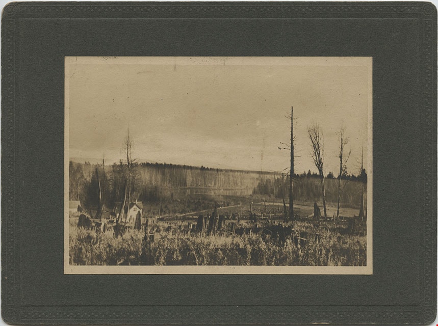
Looking from Woodlunds towards Burnaby Lake in 1899
https://search.heritageburnaby.ca/link/museumdescription992
- Repository
- Burnaby Village Museum
- Date
- 1899
- Collection/Fonds
- Burnaby Village Museum Photograph collection
- Description Level
- Item
- Physical Description
- 1 photograph : sepia photogravure ; 9.8 x 13.9 cm, mounted on cardboard 14.5 x 19.7 cm
- Scope and Content
- Photograph taken from "Woodlunds." Annotations in ink on the back of the card read, "Mr & Mrs G. Every-Clayton/ with Mr Haszard's/ wishes for a very/ Happy Xmas/ 1899" and "Looking from Woodlands / towards Burnaby Lake in 1899." Later annotation in blue ballpoint pen read, "Woodlunds the residence…
- Repository
- Burnaby Village Museum
- Collection/Fonds
- Burnaby Village Museum Photograph collection
- Description Level
- Item
- Physical Description
- 1 photograph : sepia photogravure ; 9.8 x 13.9 cm, mounted on cardboard 14.5 x 19.7 cm
- Scope and Content
- Photograph taken from "Woodlunds." Annotations in ink on the back of the card read, "Mr & Mrs G. Every-Clayton/ with Mr Haszard's/ wishes for a very/ Happy Xmas/ 1899" and "Looking from Woodlands / towards Burnaby Lake in 1899." Later annotation in blue ballpoint pen read, "Woodlunds the residence of Mr. Geo. Every-Clayton stood on the site of the present Centennial Pavilion, which when originally built was the residence of Mr. and Mrs. H.T. Ceperley. The proceeds from its sale was used to prepare the Ceperley playground in Stanley Park. The house in the left centre was that of Mr. and Mrs. Bernard R. Hill demolished to make way for entrance to Expressway."
- Names
- Every-Clayton, George
- Geographic Access
- Burnaby Lake
- Accession Code
- HV973.40.6
- Access Restriction
- No restrictions
- Reproduction Restriction
- No known restrictions
- Date
- 1899
- Media Type
- Photograph
- Scan Resolution
- 600
- Scan Date
- 2023-05-09
- Scale
- 100
- Notes
- Title based on contents of photograph
Images


Louisa Sophia "Lou" Jones Vidal
https://search.heritageburnaby.ca/link/archivedescription82360
- Repository
- City of Burnaby Archives
- Date
- [1890]
- Collection/Fonds
- Hill family and Vidal family fonds
- Description Level
- Item
- Physical Description
- 1 photograph : sepia ; 10 x 6.5 cm
- Scope and Content
- Photograph is a portrait of Louisa Sophia "Lou" Jones Vidal.
- Repository
- City of Burnaby Archives
- Date
- [1890]
- Collection/Fonds
- Hill family and Vidal family fonds
- Physical Description
- 1 photograph : sepia ; 10 x 6.5 cm
- Description Level
- Item
- Record No.
- 550-022
- Access Restriction
- No restrictions
- Reproduction Restriction
- No known restrictions
- Accession Number
- 2013-03
- Scope and Content
- Photograph is a portrait of Louisa Sophia "Lou" Jones Vidal.
- Media Type
- Photograph
- Notes
- Title based on caption accompanying photograph
- Note in pencil on album page reads: " 'To Dear Aunt Alicia' Hyde / From Lou (Louisa) Jones / c. 1890"
- Note in black pen on verso reads: "For Dear Alicia with / Lou's best love"
- Note in pencil on verso reads: "For dear Alicia with / Lou's best love"
- Photograph stamp on verso reads: "J. Barron, / Photo. / Sarnia."
Images
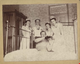
Louisa Sophia "Lou" Jones Vidal, three unidentified women and one unidentified man
https://search.heritageburnaby.ca/link/archivedescription82388
- Repository
- City of Burnaby Archives
- Date
- March 4, 1893
- Collection/Fonds
- Hill family and Vidal family fonds
- Description Level
- Item
- Physical Description
- 1 photograph : sepia ; 10.5 x 13.5 cm
- Scope and Content
- Photograph is a portrait of woman on the far right identified as Louisa Sophia "Lou" Jones Vidal with three unidentified women, looking over one unidentified man holding a bottle.
- Repository
- City of Burnaby Archives
- Date
- March 4, 1893
- Collection/Fonds
- Hill family and Vidal family fonds
- Physical Description
- 1 photograph : sepia ; 10.5 x 13.5 cm
- Description Level
- Item
- Record No.
- 550-030
- Access Restriction
- No restrictions
- Reproduction Restriction
- No known restrictions
- Accession Number
- 2013-03
- Scope and Content
- Photograph is a portrait of woman on the far right identified as Louisa Sophia "Lou" Jones Vidal with three unidentified women, looking over one unidentified man holding a bottle.
- Subjects
- Occupations - Nurses
- Media Type
- Photograph
- Notes
- Title based on caption accompanying photograph
- Note in pencil on album page photograph reads: "March 4, 1893 / Louisa Jones (far right)"
- Note in pencil on verso reads: "Louisa Vidal (far right)"
- Note in black pen on verso reads: March 4/93
- Note in blue pen on verso reads: "Gan"
Images
![Blanche Wilkinson, [between 1896 and 1900] thumbnail](/media/hpo/_Data/_Archives_Images/_Unrestricted/550/550-024.jpg?width=280)
Blanche Wilkinson
https://search.heritageburnaby.ca/link/archivedescription82374
- Repository
- City of Burnaby Archives
- Date
- [between 1896 and 1900]
- Collection/Fonds
- Hill family and Vidal family fonds
- Description Level
- Item
- Physical Description
- 1 photograph : sepia ; 10 x 6.5 cm
- Scope and Content
- Photograph is a portrait of Blanche Wilkinson.
- Repository
- City of Burnaby Archives
- Date
- [between 1896 and 1900]
- Collection/Fonds
- Hill family and Vidal family fonds
- Physical Description
- 1 photograph : sepia ; 10 x 6.5 cm
- Description Level
- Item
- Record No.
- 550-024
- Access Restriction
- No restrictions
- Reproduction Restriction
- No known restrictions
- Accession Number
- 2013-03
- Scope and Content
- Photograph is a portrait of Blanche Wilkinson.
- Subjects
- Persons - Children
- Names
- Wilkinson, Blanche
- Media Type
- Photograph
- Notes
- Title based on caption accompanying photograph
- Note in pencil on album page reads: "Blanche Wilkinson / 1890's"
- Note in pencil on verso reads: "Blanche Wilkinson / b. late 1890's"
- Photograph stamp on verso reads: "John Barron, / Photographer, / Sarnia."
Images
![Blanche Wilkinson, [between 1896 and 1900] thumbnail](/media/hpo/_Data/_Archives_Images/_Unrestricted/550/550-024.jpg)
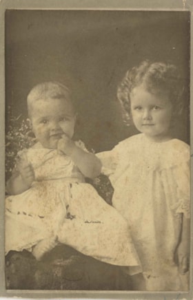
![Bruce, Bill and Mary Patterson, [between 1885 and 1890] (date of original), copied 1977 thumbnail](/media/hpo/_Data/_BVM_Images/1977/1977_0099_0010_001.jpg?width=280)
Bruce, Bill and Mary Patterson
https://search.heritageburnaby.ca/link/museumdescription568
- Repository
- Burnaby Village Museum
- Date
- [between 1885 and 1890] (date of original), copied 1977
- Collection/Fonds
- Burnaby Village Museum Photograph collection
- Description Level
- Item
- Physical Description
- 1 photograph : b&w ; 25.2 x 20.2 cm print
- Scope and Content
- Photograph of three children taken in a photographic studio. There is a boy, and a girl, both dressed in sailor suits, and a baby in a dress and white bonnet sitting on a wooden chair. The inscription and accession register identify the children as Bruce, Bill and Mary Patterson. An earlier catalog…
- Repository
- Burnaby Village Museum
- Collection/Fonds
- Burnaby Village Museum Photograph collection
- Description Level
- Item
- Physical Description
- 1 photograph : b&w ; 25.2 x 20.2 cm print
- Scope and Content
- Photograph of three children taken in a photographic studio. There is a boy, and a girl, both dressed in sailor suits, and a baby in a dress and white bonnet sitting on a wooden chair. The inscription and accession register identify the children as Bruce, Bill and Mary Patterson. An earlier catalogue record notes that the caption on the back of the original photograph read: "For Dear Grandpapa Grandma from Bruce Willie & May Patterson." An annotation on the back of this photo reads: "B. Paterson [sic], brother Bill, Mary Patterson, c. 1885-1890?"
- Accession Code
- HV977.99.10
- Access Restriction
- No restrictions
- Reproduction Restriction
- May be restricted by third party rights
- Date
- [between 1885 and 1890] (date of original), copied 1977
- Media Type
- Photograph
- Scan Resolution
- 600
- Scan Date
- 2023-07-11
- Notes
- Title based on contents of photograph
Images
![Bruce, Bill and Mary Patterson, [between 1885 and 1890] (date of original), copied 1977 thumbnail](/media/hpo/_Data/_BVM_Images/1977/1977_0099_0010_001.jpg)
Charlotte Elizabeth Vidal Hill and Dorothy Kate Vidal Loomis
https://search.heritageburnaby.ca/link/archivedescription82396
- Repository
- City of Burnaby Archives
- Date
- 1897
- Collection/Fonds
- Hill family and Vidal family fonds
- Description Level
- Item
- Physical Description
- 1 photograph : sepia ; 10.5 x 7 cm
- Scope and Content
- Photograph is a portrait of two girls identified from left to right as Charlotte Elizabeth Vidal Hill and Dorothy Kate Vidal Loomis.
- Repository
- City of Burnaby Archives
- Date
- 1897
- Collection/Fonds
- Hill family and Vidal family fonds
- Physical Description
- 1 photograph : sepia ; 10.5 x 7 cm
- Description Level
- Item
- Record No.
- 550-032
- Access Restriction
- No restrictions
- Reproduction Restriction
- No known restrictions
- Accession Number
- 2013-03
- Scope and Content
- Photograph is a portrait of two girls identified from left to right as Charlotte Elizabeth Vidal Hill and Dorothy Kate Vidal Loomis.
- Subjects
- Persons - Children
- Media Type
- Photograph
- Notes
- Title based on caption accompanying photograph
- Note in pencil on album page photograph reads: "Charlotte Elizabeth 9 mos / Dorothy Kate - 2 yrs / Vidal 1897"
- Note in blue pen on verso reads: "1897"
- Note in black pen on verso reads: "[Char]lotte Elizabeth Vidal age: 9m"
Images

![Guy, [1860-1900] thumbnail](/media/hpo/_Data/_Archives_Images/_Unrestricted/550/550-025.jpg?width=280)
Guy
https://search.heritageburnaby.ca/link/archivedescription82376
- Repository
- City of Burnaby Archives
- Date
- [1860-1900]
- Collection/Fonds
- Hill family and Vidal family fonds
- Description Level
- Item
- Physical Description
- 1 photograph : sepia ; 10 x 6.5 cm
- Scope and Content
- Photograph is a portrait of a boy identified as Guy.
- Repository
- City of Burnaby Archives
- Date
- [1860-1900]
- Collection/Fonds
- Hill family and Vidal family fonds
- Physical Description
- 1 photograph : sepia ; 10 x 6.5 cm
- Description Level
- Item
- Record No.
- 550-025
- Access Restriction
- No restrictions
- Reproduction Restriction
- No known restrictions
- Accession Number
- 2013-03
- Scope and Content
- Photograph is a portrait of a boy identified as Guy.
- Media Type
- Photograph
- Notes
- Title based on caption accompanying photograph
- Note in pencil on album page photograph reads: "Guy ?"
- Note in blue pen on verso reads: "Guy"
- Photograph stamp on verso reads: "J. Foster Elliot / Photographer, / Sarnia. / Negatives Preserved"
Images
![Guy, [1860-1900] thumbnail](/media/hpo/_Data/_Archives_Images/_Unrestricted/550/550-025.jpg)
![Herbert Penrose Vidal, [between 1880 and 1900] thumbnail](/media/hpo/_Data/_Archives_Images/_Unrestricted/550/550-028.jpg?width=280)
Herbert Penrose Vidal
https://search.heritageburnaby.ca/link/archivedescription82383
- Repository
- City of Burnaby Archives
- Date
- [between 1880 and 1900]
- Collection/Fonds
- Hill family and Vidal family fonds
- Description Level
- Item
- Physical Description
- 1 photograph : sepia ; 10 x 6.5 cm
- Scope and Content
- Photograph is a portrait of man identified as Herbert Penrose Vidal.
- Repository
- City of Burnaby Archives
- Date
- [between 1880 and 1900]
- Collection/Fonds
- Hill family and Vidal family fonds
- Physical Description
- 1 photograph : sepia ; 10 x 6.5 cm
- Description Level
- Item
- Record No.
- 550-028
- Access Restriction
- No restrictions
- Reproduction Restriction
- No known restrictions
- Accession Number
- 2013-03
- Scope and Content
- Photograph is a portrait of man identified as Herbert Penrose Vidal.
- Names
- Vidal, Herbert Penrose
- Media Type
- Photograph
- Notes
- Title based on caption accompanying photograph
- Note in pencil on album page reads: "Herbert Penrose Vidal / 1866-1934"
- Note in black pen on verso reads: "H P Vidal"
- Photograph stamp on verso reads: "Barron & Walker / Artists and Photographers / Sarnia / Ont"
Images
![Herbert Penrose Vidal, [between 1880 and 1900] thumbnail](/media/hpo/_Data/_Archives_Images/_Unrestricted/550/550-028.jpg)
![Maude, [1860-1900] thumbnail](/media/hpo/_Data/_Archives_Images/_Unrestricted/550/550-023.jpg?width=280)
Maude
https://search.heritageburnaby.ca/link/archivedescription82373
- Repository
- City of Burnaby Archives
- Date
- [1860-1900]
- Collection/Fonds
- Hill family and Vidal family fonds
- Description Level
- Item
- Physical Description
- 1 photograph : sepia ; 10 x 6 cm
- Scope and Content
- Photograph is a portrait of Maude.
- Repository
- City of Burnaby Archives
- Date
- [1860-1900]
- Collection/Fonds
- Hill family and Vidal family fonds
- Physical Description
- 1 photograph : sepia ; 10 x 6 cm
- Description Level
- Item
- Record No.
- 550-023
- Access Restriction
- No restrictions
- Reproduction Restriction
- No known restrictions
- Accession Number
- 2013-03
- Scope and Content
- Photograph is a portrait of Maude.
- Media Type
- Photograph
- Notes
- Title based on caption accompanying photograph
- Note in pencil on album page reads: "Maude ?"
- Note in blue ink on verso reads: "Maude"
- Photograph stamp on verso reads: "J. Foster Elliott, / Photographer, / Sarnia. / Negatives Preserved"
Images
![Maude, [1860-1900] thumbnail](/media/hpo/_Data/_Archives_Images/_Unrestricted/550/550-023.jpg)
![Subdivision plans in New Westminster District Group 1 – Burnaby
, [1890-1910] thumbnail](/media/hpo/_Data/_BVM_Cartographic_Material/1977/1977_0093_0014a_001.jpg?width=280)
Subdivision plans in New Westminster District Group 1 – Burnaby
https://search.heritageburnaby.ca/link/museumdescription6983
- Repository
- Burnaby Village Museum
- Date
- [1890-1910]
- Collection/Fonds
- Burnaby Village Museum Map collection
- Description Level
- File
- Physical Description
- 4 plans : blueprint ink on paper mounted on 2 sides of cardboard 76 x 102 cm
- Scope and Content
- Item consists of a large board of two New Westminster District Gp 1 - subdivision plans mounted on one side and two New Westminster District Gp 1 - subdivision plans mounted on the other side. Side A: 1. Blueprint "Plan of / Subdivision of Lot No. 69 / Group One / New Westminster District / Pro…
- Repository
- Burnaby Village Museum
- Collection/Fonds
- Burnaby Village Museum Map collection
- Description Level
- File
- Physical Description
- 4 plans : blueprint ink on paper mounted on 2 sides of cardboard 76 x 102 cm
- Material Details
- Scales [between 1:1584 and 1:3168]
- Index number on edge of board reads: "14"
- Scope and Content
- Item consists of a large board of two New Westminster District Gp 1 - subdivision plans mounted on one side and two New Westminster District Gp 1 - subdivision plans mounted on the other side. Side A: 1. Blueprint "Plan of / Subdivision of Lot No. 69 / Group One / New Westminster District / Property of Ernest Buse, Esq. / Scale 3 chs = 1 in. / Map No 290". Plan is signed by "Garden, Hermon and Burwell, Dom. Land Surveyor" (Geographic location: Burnaby) 2. Blueprint "Plan / of Subdivision / of Lots 1-19, 36-53 and 69-75 inclusive / in the Subdivision / of / Lot 30 / Group One / New Westminster District / Scale 2 chs = 1 in. Map No 631". Plan is signed by "Jno [sic] Strathern [sic] P.L.S." Names and Lot numbers are handwritten in red pencil in sections along Douglas Road and read: "20 - F / 21 - Fitherstruhaul [sic] / 22 - J.S. Craig / 23 - McGill & Dill / 24 / 25 / 26 / 27 / 28 - School / 29 - School / 30 - D. McDownall / 31 - W.J. Troloow [sic] / 32 - N.C. Nelson / 33 - _[sic] McGill / 34 - T.S.[sic] Craig / 35" (Geographic location: Burnaby) Side B: 1.Blueprint "Plan / of Subdivision / of Centre Portion / of Lot 28 / Group One / New Westminster District / Scale 200' = 1" / Map No 627". Plan is signed by "Jno Strathern / P.L.S." (Geographic location: Burnaby) 2. Blueprint "Plan / of Subdivision / of N.1/2 Lot 100 and S.1/2 Lot 101, / Group One / New Westminster District, BC / Scale 4 chs = 1 in." (Geographic location: Burnaby)
- Names
- Strathern, John
- Accession Code
- HV977.93.14
- Access Restriction
- No restrictions
- Reproduction Restriction
- No known restrictions
- Date
- [1890-1910]
- Media Type
- Cartographic Material
- Historic Neighbourhood
- Broadview (Historic Neighbourhood)
- East Burnaby (Historic Neighbourhood)
- Planning Study Area
- Cascade-Schou Area
- West Central Valley Area
- Second Street Area
- Lake City Area
- Scan Resolution
- 300
- Scale
- 72
- Notes
- Title based on contents of file
- Scale is measured in chains and feet. (One chain equals 792 inches)
- The term "Lot" can also refer to a "District Lot”
Images
![Subdivision plans in New Westminster District Group 1 – Burnaby
, [1890-1910] thumbnail](/media/hpo/_Data/_BVM_Cartographic_Material/1977/1977_0093_0014a_001.jpg)

![Survey and Subdivision plans in New Westminster District Group 1 – Burnaby
, [1861]-[1910] thumbnail](/media/hpo/_Data/_BVM_Cartographic_Material/1977/1977_0093_0019a_001.jpg?width=280)
Survey and Subdivision plans in New Westminster District Group 1 – Burnaby
https://search.heritageburnaby.ca/link/museumdescription6988
- Repository
- Burnaby Village Museum
- Date
- [1861]-[1910]
- Collection/Fonds
- Burnaby Village Museum Map collection
- Description Level
- File
- Physical Description
- 14 plans : 3 plans : black ink on paper hand col. + 7 plans : black ink on paper + 4 plans : graphite on paper mounted on 2 sides of cardboard 76 x 102 cm
- Scope and Content
- Item consists of a large board of four New Westminster District Gp 1 - subdivision plans mounted on one side and ten New Westminster District Gp 1 - subdivision plans mounted on the other side. Side A: 1. "Plan /of / Lots 166A, 166 and 167 /, Gr.1, N.W.D. / Showing Misconstructed Roads in Gree…
- Repository
- Burnaby Village Museum
- Collection/Fonds
- Burnaby Village Museum Map collection
- Description Level
- File
- Physical Description
- 14 plans : 3 plans : black ink on paper hand col. + 7 plans : black ink on paper + 4 plans : graphite on paper mounted on 2 sides of cardboard 76 x 102 cm
- Material Details
- Scales [between 1:2376 and 1:7920]
- Index number on edge of board reads: "19"
- Scope and Content
- Item consists of a large board of four New Westminster District Gp 1 - subdivision plans mounted on one side and ten New Westminster District Gp 1 - subdivision plans mounted on the other side. Side A: 1. "Plan /of / Lots 166A, 166 and 167 /, Gr.1, N.W.D. / Showing Misconstructed Roads in Green / 5 chs = 1 in.". (plan is drawn in black ink and hand coloured in red, green and orange ink). A section in the centre of the plan is coloured in red ink and identified as "C.S. Richmond" running from the North Arm of Fraser River to Wiggins Road and divided by "New Wiggins Rd. (as gazetted)" (coloured in orange ink) and two"Constructed Road(s)" (coloured in green ink). Plan is initialed by: "RB" [sic] (in blue pencil crayon) 2. Plan of / Subdivision of / Lot 166 / Group One / New Westminster District / Scale 4 chs = 1 in. / Map No 524". Plan is drawn in graphite and signed by "Surrig [sic] Welhams [sic] / P.L.S." Plan is initialed by: "RB" [sic] (in blue pencil crayon) 3. Plan of "Survey / of Highway / For / Burnaby Council / in / Lots 13 _14 / Group One / Scale 4 chs = 1 in." Signed by "Albert J. Hill, P.L.S." Caribou Street and Caribou Road run through the centre of the plan. Plan is stamped: "Albert J. Hill, Civil Engineer / and / Provincial Land Surveyor, / New Westminster, / B.C.". Plan is initialed by: "RB" [sic] (in blue pencil crayon) 4. A Plan of Lots 166A, 166 and 167, Group One, New Westminster District (drawn in graphite). A section in the centre of the plan is identified as "C.S. Richmond" running from the North Arm of Fraser River and divided by "New Wiggins Rd. (as gazetted)" and two "Constructed Road(s)". Plan is initialed by: "RB" [sic] (in blue pencil crayon) Side B: 1. Small plan drawn in black ink (no title) identifying lots north of the "North Arm" of the Fraser River. Lots identified include: Lot 99, Lot 98, Lot 157, Lot 158, Lot 163, Lot 162, Lot 159, Lot 163, Lot 162, Lot 165, Lot 166A, Lot 155B, Lot 155A and Lot 159. "Scale 40 chains to one inch" . Plan is initialed by: "RB" [sic] (in blue pencil crayon) (Geographic location: Burnaby) 2. Small plan drawn in black ink (no title) identifying lots north of the North Arm of the Fraser River as "Lots 155, 155A, 155B, 155C, 162, 163, 164, 165, 166A and 167". Plan is initialed by: "RB" [sic] (in blue pencil crayon) (Geographic location: Burnaby) 3. Small plan drawn in black ink (no title) which identifies "Lot 151 / Reserve/ for / Race Course"; "Reserve / 64 A / L. 152 G.1"; and other Lots: 32, 33, 34, 35, 36, 38, 39. The plan is signed "Surveyor G.Turn [sic] July / 61 / from Vol 40 R.L. notes [sic]" Plan is stamped: "Albert J. Hill, Civil Engineer / and / Provincial Land Surveyor, / New Westminster, / B.C." Plan is initialed by: "RB" [sic] (in blue pencil crayon) (Geographic location: Burnaby) 4. Small plan drawn in black in with faded red colouring on centre lot identified as "Lot 34" running north from "Vancouver Road" . Plan is stamped: "Albert J. Hill, Civil Engineer / and / Provincial Land Surveyor, / New Westminster, / B.C." Plan is initialed by: "RB" [sic] (in blue pencil crayon) (Geographic location: Burnaby) 5. Plan drawn in graphite and identified as "Lot 98, Gr.1," along with the intials "RB" [sic] (both are handwritten in blue crayon pencil on top of plan) The B.C.E.Railway is identified running through the plan along with Jubilee Road and Royal Oak Road. The plan is signed with the name "Wm. Murray" and the Plan is stamped: "Albert J. Hill, Civil Engineer / and / Provincial Land Surveyor, / New Westminster, / B.C.". (Geographic location: Burnaby) 6. Plan drawn in graphite identified as "Port Lot 13, Gr.1" along with the intials "RB" [sic] (both are handwritten in blue crayon pencil on top of plan) Plan is stamped: "Albert J. Hill, Civil Engineer / and / Provincial Land Surveyor, / New Westminster, / B.C.". (Geographic location: Burnaby) 7.Plan drawn in black ink and identified as "Lot 98 G.1" along with the intials "RB" [sic] (both are handwritten in blue crayon pencil on top of plan). A "Road Reservation" is identified running north between "Electric Tramway" and connecting with "Royal Oak Road". Plan is stamped: "Albert J. Hill, Civil Engineer / and / Provincial Land Surveyor, / New Westminster, / B.C." (Geographic location: Burnaby) 8. Plan drawn in black ink and divided into two sections, the upper plan is identified as "Portion / Lots 100 / area / 101, Gr.1" and the lower plan is identified as "Portion L. 3 G. 1" along with the intials "RB" [sic] (these identifiers are handwritten in blue crayon pencil on top of the plan). Portions of Lot 100 and Lot 101 are each divided into 6 sections and the Portion of Lot 3 plan is divided into 24 sections. The plan includes a note in black ink that reads: " Received from Wm Fromme [sic] / from Wm. Trapp / Nov. 28, 1895 / A. J. T...[sic]". (Geographic location: Burnaby) 9. Plan drawn in black ink (no title) identifying soil, buildings and geographic features in southern Burnaby. The plan is bordered by "New Westminster City" (Tenth Avenue and DL 172) to the south east and DL 173 to the south, DL 158 to the west and the B.C.E. Tramway to the north. Plan includes District Lots: 155A, 158, 159, 171, 160, 53 and 95 and identifies soil, marshland and ravines throughout. Plan identifies the following features: a "Team Road" running through Lots 158 and 159 along with "Fair Orchard Soil / Even Surface Throughout / No Ravines", "Gravel and Shingle" (bottom of Lot 158), "North Arm Road" crossing "Byrne Road" and connecting with "Power House Road" which runs north to connect with "Highland Park Station" and the B.C.E. Tramway, "Power Ho" in the northeast corner of DL 160, a "Brook" connected with a "Deep Ravine" running between DL 53, DL 95 and DL 160 along with "Good Soil" and "Fair Orchard Soil" identified nearby in DL 95. Scale is identified as "10 chs = 1 in." Plan is stamped: "Albert J. Hill, Civil Engineer / and / Provincial Land Surveyor, / New Westminster, / B.C." Plan is initialed by: "RB" [sic] (in blue pencil crayon) (Geographic location: Burnaby) 10. Plan drawn in black ink (no title) with Burnaby Lake and Deer Lake at the centre. The plan is bordered by the following District Lots identified as: 117, 118 and 68 to the west, Lots 80, 79 and 85 to the southwest, Lots 11, 13, and 1 (City of New Westminster) to the south east, the North Road boundary to the east and Lots 8, 56, 57, 59, and 136 to the North. The lower right hand corner of the plan has a small inset which reads: "Burnaby Lake" and "Page 19 R.B. Notes". Plan is initialed by: "RB" [sic] (in blue pencil crayon) (Geographic location: Burnaby)
- Creator
- Hill, Albert James
- Accession Code
- HV977.93.19
- Access Restriction
- No restrictions
- Reproduction Restriction
- No known restrictions
- Date
- [1861]-[1910]
- Media Type
- Cartographic Material
- Scan Resolution
- 300
- Scale
- 72
- Notes
- Title based on contents of file
- Scale is measured in chains. (One chain equals 792 inches)
- The term "Lot" can also refer to a "District Lot”
- Some plans are stamped: "Albert J. Hill, Civil Engineer / and / Provincial Land Surveyor, / New Westminster, / B.C." and intialed: "RB" [sic]
Images
![Survey and Subdivision plans in New Westminster District Group 1 – Burnaby
, [1861]-[1910] thumbnail](/media/hpo/_Data/_BVM_Cartographic_Material/1977/1977_0093_0019a_001.jpg)
