Narrow Results By
Decade
- 2020s 48
- 2010s 28
- 2000s 144
- 1990s 1950
- 1980s 574
- 1970s 718
- 1960s 385
- 1950s 585
- 1940s 707
- 1930s 793
- 1920s 708
- 1910s 555
- 1900s
- 1890s 93
- 1880s 56
- 1870s 33
- 1860s 31
- 1850s 11
- 1840s 3
- 1830s 3
- 1820s 3
- 1810s 2
- 1800s 4
- 1790s 1
- 1780s 1
- 1770s 1
- 1760s 1
- 1750s 1
- 1740s 1
- 1730s 1
- 1720s 1
- 1710s 1
- 1700s 1
- 1690s 1
- 1680s 1
- 1670s 1
- 1660s 1
- 1650s 1
- 1640s 1
- 1630s 1
- 1620s 1
- 1610s 1
- 1600s 1
- 1520s 1
Creator
- Andrews, W. & Son 1
- Banta, N. Moore (Nathaniel Moore), 1867- 1
- Barrowclough, George Alfred 1
- Brown, Cice Chandler 1
- Brown, W. 1
- Brown, William Thomas 3
- Bullen, Harry Elder 1
- Burnaby Village Museum 2
- Burnett, Geoffrey K. 1
- Burnett & McGugan, Engineers and Surveyors 7
- Castle, Agnes, 1860-1922 1
- Castle, Egerton, 1858-1920 1
![Survey and Subdivision plans in New Westminster District, Group 2 - Surrey, ʷməθkʷəy̓əm (Musqueam) Indian Reserve, [190-] thumbnail](/media/hpo/_Data/_BVM_Cartographic_Material/1977/1977_0093_0099_003.jpg?width=280)
Survey and Subdivision plans in New Westminster District, Group 2 - Surrey, ʷməθkʷəy̓əm (Musqueam) Indian Reserve
https://search.heritageburnaby.ca/link/museumdescription7068
- Repository
- Burnaby Village Museum
- Date
- [190-]
- Collection/Fonds
- Burnaby Village Museum Map collection
- Description Level
- File
- Physical Description
- 11 plans : graphite and ink on paper and linen + blueprint ; various sizes mounted on 2 sides of cardboard 76 x 102 cm
- Scope and Content
- File consists of a large board with eleven plans in New Westminster District (Group 2) mounted on one side and five plans in New Westminster District (Group 2) mounted on the other side. Side A: 1. Plan : black ink on linen ; 19.5 x 32 cm. Title reads: "Yale Road / Sec.9 & 10 / B5N R2W" (in blue …
- Repository
- Burnaby Village Museum
- Collection/Fonds
- Burnaby Village Museum Map collection
- Description Level
- File
- Physical Description
- 11 plans : graphite and ink on paper and linen + blueprint ; various sizes mounted on 2 sides of cardboard 76 x 102 cm
- Material Details
- Scales vary (One chain equals 792 inches)
- Indexed number on tape on edge of board reads "99"
- Scope and Content
- File consists of a large board with eleven plans in New Westminster District (Group 2) mounted on one side and five plans in New Westminster District (Group 2) mounted on the other side. Side A: 1. Plan : black ink on linen ; 19.5 x 32 cm. Title reads: "Yale Road / Sec.9 & 10 / B5N R2W" (in blue crayon). Scale: 400 chains = 1 inch. Initals in blue crayon: "RB". Survey plan of Yale Road running through Sections 9 and 10 in New Westminster District, Group 2. (Geographic location: Surrey) 2. Plan : blueprint on paper ; 35.5 x 77.5 cm. Title reads: "Victoria Terminal Railway & Ferry Co. / Plan showing / Proposed Change of Wagon Road through White Rock, B.C" Scale: 400 feet = 1 inch. "H.C. Brice / Engineer in charge / New Westminster, B.C.". February 1906. Signed by "Walter Wilkie B.C.L.S.". Annotation in blue crayon reads: "Sub. of Parts of Sec. 10 & 11 / Tp. 1". Semiahmoo Indian Reserve, Washington Ave., Feb. 1906; 2. Yale Road, Sec.9, 10, B5N R2W, River Rd.; (Geographic location: White Rock) 3. Plan : graphite on paper ; 34 x 94 cm. Title reads: "Tp 7 / NW District" (in graphite) and "Campbell River / in Twp. 7" (in blue crayon). TP7, New Westminster District, Campbell R. in TP4, Coast Meridian, Bamford; (Geographic location: Surrey) Side B: 1. Plan : black ink and col. ink on paper ; 28 x 38.5 cm. Title reads: "G.N.R. / South approach to Wests bridge" (in blue crayon). Scale: 2 chains = 1 inch. Signed by Albert J. Hill, B.C.L.S. Plan covers land in Lot 2, Group 2 and ʷməθkʷəy̓əm (Musqueam) Indian Reserve with approach to bridge running through. (Geographic location: Surrey) 2. Plan : black ink and col. ink on paper ; 26.5 x 44.5 cm. Title reads: "Plan / of / River Frontage / across / Lot 1 BI.N.R.2W. and Lot 6, B.I.N.R.I.W. / N.W.D." Scale: 6 chains = 1 inch. Stamp in red ink reads: "Albert J. Hill, M.A., / Civil Engineer / and / Provincial Land Surveyor, / New Westminster, / B.C." (Geographic location: Surrey) 3. Plan : graphite and ink on paper ; 27 x 44.5 cm. (no formal title) Plan covers area between Yale Road, (north), Quible Road (west) and Townline Road (south). Scale: 4 chains = 1 inch. Signed by Albert J. Hill, B.C.L.S. Annotations in blue crayon read: "also Board 83 / Cancelled" (Geographic location: Surrey) 4. Plan : graphite on paper ; 35.5 x 21.5 cm. Title reads: "Sec 33 B.5N. R2W / see finished drawing Board 125". Initials in blue crayon "RB". Plan certifified by B.C. Provincial Land Surveyor in blue ink "Albert J. Hill". 5. Plan : black ink and col. ink on linen ; 15.5 x 22 cm. Title reads: " Lot 167 Gr. 2" (blue crayon). Scale: 200 feet = 1 inch. Signed by Albert J. Hill, Provincial Land Surveyor. Survey of aarea north of Cloverdale & Guichon Railway with area identified as "Gravel Pit". "Cancelled" in upper left corner of plan. (Geographic location: Surrey) 6. Plan : graphite on paper ; 27 x 27.5 cm. Title reads: "South Half / of / S.W.1/4 Sec.31 TP7 / N.W.D.". Scale: 5 chains = 1 inch. Other title at top of plan reads; "Edward Parr [sic] / Cloverdale". Covers area east of Coast Meridian Road in Section 36. (Geographic location: Surrey) 7. Plan : graphite on paper ; 20.5 x 16 cm. Title reads: "Survey of [sic] Sec. 16, Tp 1[sic] / ..." Other title in blue crayon reads: "N.E. 1/4 Sec. 16 / Twp. 1". (Geographic location: Surrey) 8. Plan : graphite on paper. ; 26.5 x 35 cm. (title is illegible) Plan covers are in New Westminster District, Group 2 along the south shore of the Fraser River. (Geographic location: Surrey)
- Creator
- Hill, Albert James
- Accession Code
- HV977.93.99
- Access Restriction
- No restrictions
- Reproduction Restriction
- No known restrictions
- Date
- [190-]
- Media Type
- Cartographic Material
- Scan Resolution
- 600
- Scan Date
- 2023-06-26
- Notes
- Title based on contents of file
Zoomable Images
![Survey and Subdivision plans in New Westminster District, Group 2 - Surrey, ʷməθkʷəy̓əm (Musqueam) Indian Reserve, [190-] thumbnail](/media/hpo/_Data/_BVM_Cartographic_Material/1977/1977_0093_0099_003_seadragon/1977_0093_0099_003.jpg?w=280)
Survey and Subdivision plans in New Westminster District, Group 2 - Surrey, ʷməθkʷəy̓əm (Musqueam) Indian Reserve, [190-]
Zoom into Image
![Survey and Subdivision plans in New Westminster District Group 2 - Surrey, ʷməθkʷəy̓əm (Musqueam) Indian Reserve, [190-] thumbnail](/media/hpo/_Data/_BVM_Cartographic_Material/1977/1977_0093_0086_001.jpg?width=280)
Survey and Subdivision plans in New Westminster District Group 2 - Surrey, ʷməθkʷəy̓əm (Musqueam) Indian Reserve
https://search.heritageburnaby.ca/link/museumdescription7055
- Repository
- Burnaby Village Museum
- Date
- [190-]
- Collection/Fonds
- Burnaby Village Museum Map collection
- Description Level
- File
- Physical Description
- 12 plans : graphite and ink on paper and linen; various sizes mounted on 2 sides of cardboard 76 x 102 cm
- Scope and Content
- File consists of a large board with twelve plans (six plans mounted on each side). All plans are located in New Westminster District, Group 2, covering geographic areas within Surrey. Side A: 1. Plan : black ink on paper ; 20.5 x 57.5 cm. Title reads: "Extension of Tram Line / Hospital to Distill…
- Repository
- Burnaby Village Museum
- Collection/Fonds
- Burnaby Village Museum Map collection
- Description Level
- File
- Physical Description
- 12 plans : graphite and ink on paper and linen; various sizes mounted on 2 sides of cardboard 76 x 102 cm
- Scope and Content
- File consists of a large board with twelve plans (six plans mounted on each side). All plans are located in New Westminster District, Group 2, covering geographic areas within Surrey. Side A: 1. Plan : black ink on paper ; 20.5 x 57.5 cm. Title reads: "Extension of Tram Line / Hospital to Distillery St." Scales: Hor: 100 feet = 1 inch; Vert: 20 feet = 1 inch. tram line, hospital to distillery street; 2. Plan : black ink on linen ; 55 x 46.5 cm. (no title). Plan covers New Westminster District, Group 2, Lots 1,2, 3,4, A and B and the ʷməθkʷəy̓əm (Musqueam) Indian Reserve (1868).along the south shore of the Fraser River opposite City of New Westminster. Portion of land is highlighted in blue along the west border of the "ʷməθkʷəy̓əm (Musqueam) Indian Reserve" and between Lot 2 and Lot 1 and survey lines identified as "Mohun's Line" and Hill's Line. Stamp in red ink on plan reads: "Albert J. HIll, M.A. / Civil Engineer / and Provincial Land Surveyor / New Westminster / B.C." (Geographic location: Surrey also formerly known as Brownsville) 3. Plan : black ink on paper ; 34.5 x 23 cm. Title reads: "Lot 51, Gr.2" (in blue crayon). Plan covers area in New Westminster, Group 2, District Lot 51, north of Mud Bay with the Victoria Terminal Railway and Great Northern Railway lines identified. (Geographic location: Surrey) 4. Plan : graphite on paper ; 16.5 x 18 cm. Title reads: "Sec.20, B5N R2W" (underlined in blue crayon). Sketch plan covers and area in New Westmninster District, Group 2. Plan includes initials "RB" in blue crayon. Scale: 5 chains = 1 inch (Geographic location: Surrey) 5. Plan : graphite on paper with annotations in black ink ; 17 x 21 cm. Title reads: "N.W.1/4 Sec.12 TP2" (in blue crayon). Plan covers an area in New Westminster District Group 2 in Section 12, south of Bose Road. Identifying land marks include names: "Bose", "Smith" and "Church Land" Scale: 8 chains = 1 inch (Geographic location: Surrey) 6. Plan : graphite on paper ; 38 x 26.5 cm. (no title) Sketch plan covers areas in Lot 1 and Lot 2 with land identified as "Dominion Government". (could be survey for ʷməθkʷəy̓əm (Musqueam) Indian Reserve) (Geographic location: Surrey also formerly known as Brownsville) Side B: 1. Plan: black ink on paper ; 53.5 x 38 cm. Title reads:"Plan of Subdivision / of / Section 27, / Block 5 North, Range 2 West / New Westminster District". Scale: 4 chains = 1 inch. Includes area subdivided into 18 lots, south of Hjorth Road (104th Avenue) and west of Quible Road with Yale Road running through. Note in blue crayon reads: See also Bd.93) (Geographic location: Surrey) 2. Plan : black ink on paper ; 35 x 28 cm. Title reads: "Plan / of / Block A - L387A / Surrey". Scale: 2 chains = 1 inch. Annotaion in blue crayon reads: "Blk A / Lot 387a_Gr. 2". Plan covers New Westminster District Group 2, Block A, Lot 387 A, south of Parsons Slough and east of Latimer Road (192nd Street). Stamp in red ink on plan reads: "Albert J. HIll, M.A. / Civil Engineer / and Provincial Land Surveyor / New Westminster / B.C." (Geographic location: Surrey) 3. Plan : black ink on linen ; 50 x 42 cm. Title reads: Plan / of part of / Campbell River / running through / the South portion / of N.E. 1/4, Section 8, / Tp. 7, East of Coast Meridian / also / Showing location / of Shingle Mill and Dam". Scale: 100 feet = 1 inch. Plan covers the area in New Westminster District, Township 7, Section 8 with Hall's Prairie Road (184th Street) running through and intersecting with Campbell River. Vegetation, buildings, bridge, shingle mill are identified. (Geographic location: Surrey) 5. Plan : black ink on linen ; 21.5 x 16.5 cm. Title reads: "Sec.32, B5N R2W". Scale: 10 chains = 1 inch. Signed by "Albert J. Hill / B.C.L.S. / Dec. 23, 1908". Note on survey reads: "No actual survey / 40 ac. surveyed". (Geographic location: Surrey) 6. Plan : graphite on paper ; 22 x 15.5 cm. Title reads: "Position 'A5' Subjects / by _McKenzie" [Geographic location: Surrey]
- Creator
- Hill, Albert James
- Names
- ʷməθkʷəy̓əm (Musqueam)
- Accession Code
- HV977.93.86
- Access Restriction
- No restrictions
- Reproduction Restriction
- No known restrictions
- Date
- [190-]
- Media Type
- Cartographic Material
- Scan Resolution
- 600
- Scan Date
- 2023-06-26
- Notes
- Title based on contents of file
- Numeric stamp on edge of board reads: "86"
Zoomable Images
![Survey and Subdivision plans in New Westminster District Group 2 - Surrey, ʷməθkʷəy̓əm (Musqueam) Indian Reserve, [190-] thumbnail](/media/hpo/_Data/_BVM_Cartographic_Material/1977/1977_0093_0086_003_seadragon/1977_0093_0086_003.jpg?w=280)
Survey and Subdivision plans in New Westminster District Group 2 - Surrey, ʷməθkʷəy̓əm (Musqueam) Indian Reserve, [190-]
Zoom into Image
Kiewitz family
https://search.heritageburnaby.ca/link/archivedescription88222
- Repository
- City of Burnaby Archives
- Date
- [1900]-[1950] (date of originals), copied [199-]
- Collection/Fonds
- Mary Forsyth fonds
- Description Level
- File
- Physical Description
- 44 photographs: b&w and sepia ; 20 x 25 cm or smaller
- Scope and Content
- Photographs of the Kiewitz and the Dedul families.
- Repository
- City of Burnaby Archives
- Date
- [1900]-[1950] (date of originals), copied [199-]
- Collection/Fonds
- Mary Forsyth fonds
- Physical Description
- 44 photographs: b&w and sepia ; 20 x 25 cm or smaller
- Description Level
- File
- Record No.
- 572-018
- Access Restriction
- In Archives only
- Reproduction Restriction
- No reproduction permitted
- Accession Number
- 2014-27
- Scope and Content
- Photographs of the Kiewitz and the Dedul families.
- Media Type
- Photograph
- Notes
- Transcribed title
- Includes 20 photocopied photographs (572-018-21:572-018-41) and 1 copy negative
- Note in blue ink on verso of photograph 572-018-4 reads: "Lizabeth you know where that was taken & who all in it"
- Note in pencil on verso of photograph 572-018-6 reads: "Remembrance of the family taken before Xmas 1931"
- Note in pencil on verso of photograph 572-018-7 reads: "Dad I think, Bean hay & me"
- Stamp on verso of photograph 572-018-8 reads: "Post Card/ Made in Canada/ Correspondence/ Address/ Place Stamp here"
- Note in blue ink on verso of photograph 572-018-11 reads: "Mary Bolton, Robert Kiewitz, Floyd Butterfield, Dick Dunlap & Gertie Kiewitz on No.99 Highway, Washington/ July, 19, 1938
- Note in black ink on verso of photograph 572-018-12 reads: "Snowball tree in bloom of course not this spring. With Chrissie Scott, Margery Mineess, Gertrude in fore ground/ I can't remember whether I've send one of these snaps before"
- Stamp on verso of photograph 572-018-14 reads: "127"
- Note in ink on verso of photograph 572-018-15 reads: "Mary Bolton near tent pole Silver Lake Camp/ Mt.Everard Washington U.S.A."
- Stamp on verso of photograph 572-018-16 reads: "718"
- Stamp on verso of photograph 572-018-17 reads: "973"
- Stamp on verso of photograph 572-018-18 reads: "465"
- Note in pencil on verso of photograph 572-018-19 reads: "W. Kiewitz/ 841-4th St. New West'r"
- Note in pencil on envelope for copy-negative reads: "Julia/ Gertie/ Annie/ Jenny/ Bolton's Pond/ Julia on Bolton's
![Survey and Subdivision plans in New Westminster District Group 2 - Surrey, ʷməθkʷəy̓əm (Musqueam) Indian Reserve, [190-] thumbnail](/media/hpo/_Data/_BVM_Cartographic_Material/1977/1977_0093_0093_003.jpg?width=280)
Survey and Subdivision plans in New Westminster District Group 2 - Surrey, ʷməθkʷəy̓əm (Musqueam) Indian Reserve
https://search.heritageburnaby.ca/link/museumdescription7062
- Repository
- Burnaby Village Museum
- Date
- [190-]
- Collection/Fonds
- Burnaby Village Museum Map collection
- Description Level
- File
- Physical Description
- 10 plans : blueprints on paper ; various sizes mounted on 2 sides of cardboard 76 x 102 cm
- Scope and Content
- File consists of a large board with ten plans (5 plans mounted on each side). All plans are located in New Westminster District, Group 2, covering geographic areas within Surrey. Side A: 1. Plan : blueprint on paper ; 57 x 33 cm. Title reads: "Plan / of the Subdivision of / Block 23 / in / Sec. 3…
- Repository
- Burnaby Village Museum
- Collection/Fonds
- Burnaby Village Museum Map collection
- Description Level
- File
- Physical Description
- 10 plans : blueprints on paper ; various sizes mounted on 2 sides of cardboard 76 x 102 cm
- Material Details
- Scales vary (One chain equals 792 inches)
- Indexed number on tape on edge of board reads "93"
- Scope and Content
- File consists of a large board with ten plans (5 plans mounted on each side). All plans are located in New Westminster District, Group 2, covering geographic areas within Surrey. Side A: 1. Plan : blueprint on paper ; 57 x 33 cm. Title reads: "Plan / of the Subdivision of / Block 23 / in / Sec. 31 B5N R2W / N.W. Dist." Located in New Westminster District Group 2. Scale; 40 feet = 1 inch. Signed by Albert J. Hill, Provincial Land Surveyor. Subdivision plan covers land in Block 23 of Section 31 (New Westminster District, Group 2) south of Albert Street, north of Surrey Street and west of Fourth Avenue. (Geographic location: Surrey) 2. Plan : blueprint on paper ; 38.5 59.5 cm. Title reads: "Plan / of ʷməθkʷəy̓əm (Musqueam) Indian Reserve / And / Right-of-Way / for / Bridge Approach". Scale: 100 feet = 1 inch. Signed by Albert J. Hill, Provincial Land Surveyor, June 28, 1902. Plan covers the location of the ʷməθkʷəy̓əm (Musqueam) Indian Reserve in New Westminster District, Group 2, Lot 1 on the south shore of the Fraser River situated between lots owned by Herring (Lot B) and F. Clarke. Plan includes locations of buildings on F. Clarke's property and also includes the location of Roman Catholic Church located on ʷməθkʷəy̓əm (Musqueam) Indian Reserve. (Geographic location: Surrey) 3. Plan : blueprint on paper ; 26 x 35.5 cm. Title reads: "Section 35_B.5N._R.2W". Plan covers areas of land in Section 35 bordered by Section 36 and Section 26 in New Westminster District Group 2 (plan appears to be reversed with Section 26 to the north and Section 35 to the south). Yale Wagon Road is identified running through Section 35. 4. Plan : blueprint on paper ; 21 x 37.5 cm. Title reads: "Traverse of the Water Line / in front of / Lots 3 and 4 Group 2 / N.W.D. / with G.N. Railway Rt. of Way". Scale: 100 feet = 1 inch. Signed by Albert J. Hill, B.C. Land Surveyor. Plan covers the location of the water line with the Great Northern Railway Right of Way within New Westminster District, Group 2, Lots 3 and 4 on the south shore of the Fraser River. (Geographic location: Surrey) 5. Plan : blueprint on paper ; 75 x 52.5 cm. Title reads: "Plan / of Block 7 and 8 / of the / 5 W.1/4 Sec.6, TWP. 7 / N.W.D.". Scale: 1/12 chains = 1 inch. Annotation in red crayon reads "see Boards 85 & 207".Signed by Albert J. Hill, B.C. Land Surveyor. The plan is bordered by "O'Connell Street" to the north, "Columbia Avenue" to the west, "Westland Row" to the east and the International Boundary to the south. (Geographic location: Surrey) Side B: 1. Plan : blueprint on paper ; 60 x 39.5 cm. Title reads: "Plan / of Subdivision 'B' / of Section 20 / B5N R2W / New Westminster Distr." Scale: 2 chains = 1 inch. Signed by Albert J. Hill, B.C. Land Surveyor. Plan covers subdivision "B" in Section 20, New Westminster District, Group 2. (Geographic location: Surrey) 2. Plan : blueprint on paper ; 42 x 29.5 cm. Title reads: "Section 32, / Township 8, / New Westminster District". Scale 10 chains = 1 inch. Lot owners are identified as; Childs, Thompson, Gordon and Layfield bordered by Clover Valley Road to the west and Hall's Prairie Road to the east and Township Line Road and Lot 121 and Lot 99 to the north. Note in blue crayon reads: "also Board 80" (Geographic location: Surrey) 3. Plan : blueprint on paper ; 18 x 21 cm. Title reads: "N.E.1/4 Sec.21 / TP1". Ceritified by Albert J. Hill, B.C. Land Surveyor. Includes property identified as "Mr. Feedham". (Geographic location: Surrey) 4. Plan : blueprint on paper ; 27 x 19 cm. Title in blue crayon reads: "Sec 25 B5N. R3W / also see Board 91". Scale: 4 chaines = 1 inch. Signed by Albert J. Hill, B.C. Land Surveyor. Survey area includes land north of the intersection of Ladner Road and Scott Road. (Geographic location: Surrey) 5. Plan : blueprint on paper ; 53 x 34 cm. Title reads: "Plan of Subdivision / of / Section 27, / Block 5 North, Range 2 West, / New Westminster District". Scale: 4 chains - 1 inch. Signed by Albert J. Hill, Provincial Land Surveyor, [August 13, 1900]. Property in Section 27 bordered by Hjorth Road to the north, Quible Road to the east and Yale Road to the south. (Geographic location: Surrey)
- Creator
- Hill, Albert James
- Names
- ʷməθkʷəy̓əm (Musqueam)
- Accession Code
- HV977.93.93
- Access Restriction
- No restrictions
- Reproduction Restriction
- No known restrictions
- Date
- [190-]
- Media Type
- Cartographic Material
- Scan Resolution
- 600
- Scan Date
- 2023-06-26
- Notes
- Title based on contents of file
Zoomable Images
![Survey and Subdivision plans in New Westminster District Group 2 - Surrey, ʷməθkʷəy̓əm (Musqueam) Indian Reserve, [190-] thumbnail](/media/hpo/_Data/_BVM_Cartographic_Material/1977/1977_0093_0093_003_seadragon/1977_0093_0093_003.jpg?w=280)
Survey and Subdivision plans in New Westminster District Group 2 - Surrey, ʷməθkʷəy̓əm (Musqueam) Indian Reserve, [190-]
Zoom into Image
![Survey and Subdivision plans in New Westminster District Group 1 & Group 2 - Burnaby, Port Moody, Coquitlam, Mission and Map of Port Simpson Harbour, [190-] thumbnail](/media/hpo/_Data/_BVM_Cartographic_Material/1977/1977_0093_0111_001.jpg?width=280)
Survey and Subdivision plans in New Westminster District Group 1 & Group 2 - Burnaby, Port Moody, Coquitlam, Mission and Map of Port Simpson Harbour
https://search.heritageburnaby.ca/link/museumdescription7080
- Repository
- Burnaby Village Museum
- Date
- [190-]
- Collection/Fonds
- Burnaby Village Museum Map collection
- Description Level
- File
- Physical Description
- 9 plans : 3 plans : blueprint ink on paper + 4 plans : black ink and graphite on linen + 2 plans : graphite on paper mounted on 2 sides of cardboard 76 x 102 cm
- Scope and Content
- File consists of a large board with five plans in New Westminster District, Group 1 mounted on one side and three plans in New Westminster District, Group 1 and a map of Port Simpson Harbour mounted on the other side. Side A: 1. Plan: blueprint on paper ; 30 x 20 cm. Title reads: "Plan of / Subdi…
- Repository
- Burnaby Village Museum
- Collection/Fonds
- Burnaby Village Museum Map collection
- Description Level
- File
- Physical Description
- 9 plans : 3 plans : blueprint ink on paper + 4 plans : black ink and graphite on linen + 2 plans : graphite on paper mounted on 2 sides of cardboard 76 x 102 cm
- Material Details
- Scales vary (One chain equals 792 inches)
- Indexed number on tape on edge of board reads "111"
- Scope and Content
- File consists of a large board with five plans in New Westminster District, Group 1 mounted on one side and three plans in New Westminster District, Group 1 and a map of Port Simpson Harbour mounted on the other side. Side A: 1. Plan: blueprint on paper ; 30 x 20 cm. Title reads: "Plan of / Subdivision of Part of D.L.172.GR.I.N.W.D." Scale: 200 feet = 1inch. dated, Feb.22, 1908, signed by land surveyor "Noel Humphreys" (Geographic location: District Lot 172, Burnaby) 2. Plan : graphite and blue crayon on paper ; 21.5 x 22 cm. Title in blue crayon reads: "N.E.1/4 & NW 1/4 Sec.25 / Tp 18". Scale: 10 chains=1 inch (Geographic location: Mission) 3. Plan : graphite on paper ; 31.5 x 16 cm. Title in blue crayon reads: "Lot 350_ Gr.1" with initials "RB". Scale : 3 chains = 1 inch. (Geographic location: Port Moody) 4. Plan ; graphite on linen ; 40 x 54 cm. Title in blue crayon reads: "Lot 190_Gr.1" with initials "RB". Plan covers area in Lot 190 including streets identified as; McInness Street, First Street, Second Street, Third Street, Fourth Street running through District Lot. (Geographic location: Port Moody) 5. Plan: blueprint on paper ; 50.5 x 57.5 cm. Title reads: "Plan of / T.F. Sinclair's Quarry Site. / SituateOnPittRiver.Sec.122T.P.40. / East of Coast Mer." Scale: 5 chains = 1inch. dated June 30 1908 [sic] Plan covers site of T.F. Sinclair's quarry in Section 22 of Township 40 on the shore of Pitt River. (Geographic location: Coquitlam ) Side B: 1. Map : blueprint on paper ; 50 x 38 cm. Scale: 40 chains - 1 inch. Title reads: "Map of Land on / Port Simpson Harbor". Scale : 40 chains = 1 inch Map covers subdivided land on the North Coast of British Columbia on the Tsimpsean Pennisula bordered by water identified as "Work Channel" to the west, "Port Simpson Harbour" to the east and land identified as "Indian Reserve" [Lax Kw'alaams] to the south. Names of property owners are identified in subdivided sections and area of land along the shore of "Work Channel" is identified as "Goverment Reserve". Blueprint includes inset "Key Map" with location of Port Simpson Harbour and Tsimpean Pennisula on the North Coast of British Columbia. 2. Plan : graphite on linen ; 24.5 x 46 cm. Title reads: "Portion of Lot 470 / Group 1" Scale : 2 chains = 1 inch. Plan covers a subdivided portion of District Lot 470, New Westminster District, Group 1 with streets identified as; "Pleasant Street", "Metta Street" and "Clarence Street". (Geographic location: Port Moody) 3. Plan : black ink on linen ; 40 x 30.5 cm. Title reads: "Plan / of / A Portion of the Foreshore / of / Lot 201 GR.2 / N.W.D. / Showing / Mill-Site". Scale : 100 feet = 1 inch. Plan is stamped in red ink: "Albert J. Hill, M.A., / Civil Engineer / And / Provincial Land Surveyor, / New Westminster, / B.C.". Survey notes in black ink read: "Surveyed Oct 9th 1908 for Messrs. / Roe & Abernathy and plan (duplicate / of this one) sent Oct. 8th / G.K. Burnett". (Geographic location : Port Moody) 4. Plan : black and red ink on line ; 63 x 29.5 cm. Title reads: "Port Moody / Butchard's Property". Scale : 200 feet = 1 inch. Plan covers subdivided lot into 16 parcels numbered I to XVI along the north shore of Burrard Inlet in Port Moody. Streets are identified as; George Street, Bruce Street, Norval Street, Nora Street, Elm Street, Pine Street, Orr Street and Orchard Street. Roads are identified as; West Road and East Road. (Geographic location : Port Moody)
- Creator
- Hill, Albert James
- Accession Code
- HV977.93.111
- Access Restriction
- No restrictions
- Reproduction Restriction
- No known restrictions
- Date
- [190-]
- Media Type
- Cartographic Material
- Scan Resolution
- 600
- Scan Date
- 2023-06-26
- Notes
- Title based on contents of file
Zoomable Images
![Survey and Subdivision plans in New Westminster District Group 1 & Group 2 - Burnaby, Port Moody, Coquitlam, Mission and Map of Port Simpson Harbour, [190-] thumbnail](/media/hpo/_Data/_BVM_Cartographic_Material/1977/1977_0093_0111_003_seadragon/1977_0093_0111_003.jpg?w=280)
Survey and Subdivision plans in New Westminster District Group 1 & Group 2 - Burnaby, Port Moody, Coquitlam, Mission and Map of Port Simpson Harbour, [190-]
Zoom into Image
![Survey plans in New Westminster District Group 1 - Maple Ridge, Pitt Meadows, [190-] thumbnail](/media/hpo/_Data/_BVM_Cartographic_Material/1977/1977_0093_0105_001.jpg?width=280)
Survey plans in New Westminster District Group 1 - Maple Ridge, Pitt Meadows
https://search.heritageburnaby.ca/link/museumdescription7074
- Repository
- Burnaby Village Museum
- Date
- [190-]
- Collection/Fonds
- Burnaby Village Museum Map collection
- Description Level
- File
- Physical Description
- 6 plans : graphite and ink on paper and linen; various sizes mounted on 2 sides of cardboard 76 x 102 cm
- Scope and Content
- File consists of a large board with three plans mounted on one side and two on the other side. All plans are located in New Westminster District, Group 2, covering geographic areas within Maple Ridge and Pitt Meadows. Side A: 1. Plan : black ink on linen ; 34 x 86 cm. Title reads: "Survey / of / …
- Repository
- Burnaby Village Museum
- Collection/Fonds
- Burnaby Village Museum Map collection
- Description Level
- File
- Physical Description
- 6 plans : graphite and ink on paper and linen; various sizes mounted on 2 sides of cardboard 76 x 102 cm
- Material Details
- Scales vary (One chain equals 792 inches)
- Indexed number on tape on edge of board reads "105"
- Scope and Content
- File consists of a large board with three plans mounted on one side and two on the other side. All plans are located in New Westminster District, Group 2, covering geographic areas within Maple Ridge and Pitt Meadows. Side A: 1. Plan : black ink on linen ; 34 x 86 cm. Title reads: "Survey / of / Dyke and Waterfront / Sec's 9, 10, 11, 13 & 14 / B5N R1E". Scale: 400 feet = 1 inch. Stamp in red ink on plan reads: "Albert J. Hill, M.A., / Civil Engineer / And / Provincial Land Surveyor, / New Westminster, / B.C." (Geographic location: Pitt Meadows) 2. 2 plans : black ink and graphite on paper ; 34.5 x 51 cm. Titles read: "Survey / For Highway / in / Section 4, Township 15, / New Westminster District. / For Maple Ridge Council." and "Survey / for Highway / in / Section 5, Tp. 15, / New Westminster Dist. / For Maple Ridge Council." Survey plan in Section 5, Township 15, covers SW quarter of Sec. 5, Tp. 15 with "Indian Reserve" (Whonnock Indian Reserve No. 1 - Kwantlen First Nation) identified. Stamp in red ink on plan reads: "Albert J. Hill, M.A., / Civil Engineer / And / Provincial Land Surveyor, / New Westminster, / B.C." Scales vary per drawing: 4 chains = 1 inch and 2 chains = 1 inch. (Geographic location: Maple Ridge) 3. Plan, black ink and graphite on paper ; 41 x 34 cm. Title reads: "Plan / of Subdivision / of / Fractional S.E. Quarter / of Sec. 6, TP. 15 / New Westminster District". Scale: 4 chains = 1 inch tamp in red ink on plan reads: "Albert J. Hill, M.A., / Civil Engineer / And / Provincial Land Surveyor, / New Westminster, / B.C." . Annotation in blue crayon reads: "also Board 122. (Geographic location: Maple Ridge) Side B: 1. Plan : black ink and col. red ink on linen ; 25.5 x 16 cm. Title reads: "Plan of Survey in Lot 398 Gr. 1 / For Lougheed & Abernathy". Scale: 3 chains = 1 inch. Plan is signed by "G.K. Burnett" September 25, 1907. (Geographic location: Maple Ridge) 2. Plan : graphite on paper with annotations in blue ; 91 x 67 cm. Title on survey plan reads: "Lot 441, 439, 438, 440, Gr. 1 / Showing bank of Stave River" (in blue crayon). Survey plan includes lot numbers and identifies "Indian Reserve" (Whonnock Indian Reserve No. 1 - Kwantlen First Nation) (Geographic location: Maple Ridge)
- Accession Code
- HV977.93.105
- Access Restriction
- No restrictions
- Reproduction Restriction
- No known restrictions
- Date
- [190-]
- Media Type
- Cartographic Material
- Scan Resolution
- 600
- Scan Date
- 2023-06-26
- Notes
- Title based on contents of file
Zoomable Images
![Survey plans in New Westminster District Group 1 - Maple Ridge, Pitt Meadows, [190-] thumbnail](/media/hpo/_Data/_BVM_Cartographic_Material/1977/1977_0093_0105_003_seadragon/1977_0093_0105_003.jpg?w=280)
Survey plans in New Westminster District Group 1 - Maple Ridge, Pitt Meadows, [190-]
Zoom into Image
![Survey and Subdivision plans in New Westminster District Group 2 - Surrey, Delta
, [1898-1910] thumbnail](/media/hpo/_Data/_BVM_Cartographic_Material/1977/1977_0093_0078_001.jpg?width=280)
Survey and Subdivision plans in New Westminster District Group 2 - Surrey, Delta
https://search.heritageburnaby.ca/link/museumdescription7047
- Repository
- Burnaby Village Museum
- Date
- [1898-1910]
- Collection/Fonds
- Burnaby Village Museum Map collection
- Description Level
- File
- Physical Description
- 10 plans : graphite and ink on paper and linen; various sizes mounted on 2 sides of cardboard 76 x 102 cm
- Scope and Content
- File consists of a large board with four plans in New Westminster District mounted on one side and six plans mounted on the other side. Side A: 1. Plan : black ink on paper with colour (no formal title). Plan covers area in New Westminster District, Group 2 situated along the south shore of the …
- Repository
- Burnaby Village Museum
- Collection/Fonds
- Burnaby Village Museum Map collection
- Description Level
- File
- Physical Description
- 10 plans : graphite and ink on paper and linen; various sizes mounted on 2 sides of cardboard 76 x 102 cm
- Material Details
- Scales vary
- Indexed number on tape on edge of board reads "78"
- Scope and Content
- File consists of a large board with four plans in New Westminster District mounted on one side and six plans mounted on the other side. Side A: 1. Plan : black ink on paper with colour (no formal title). Plan covers area in New Westminster District, Group 2 situated along the south shore of the Fraser River identified as "Indian Reserve / Turner 1868" situated in District Lot 1 between District Lot 2 identified as "Mohun's Line" and "Herring's Line" bordered by lots B and A. Includes note "see plan of subdivision of Lots 3 & 4 Gr. 2". (Geographic location: Surrey) 2. Plan : graphite on paper ; Title reads: "B5N R2W, Sec.26_Sec. 28 / Sec. 35_Sec.36". Plan covers a 60 acre parcel in Sec. 35 with Yale wagon road to the south. Scale: 6 chains = 1 inch (Geographic location: Surrey) 3. Plan : black ink on paper ; Title reads: "Survey for Proposed Highway in Indian Reserve Surrey". Plan covers area of land to the northwest of Lot 2 along the shore of the Fraser River and identfies route of proposed highway, proposed tramway as well at the Great Northern Railway and bridge. Scale: 2 chains = 1 inch 4. Plan : black ink on red lined graphing paper ; Title reads: "Sketch Plan Showing Section of Great Northern R. of W. at Point of Crossing of Proposed Ditch". Plan covers area of Lot 2 in New Westminster District, Group 2. (Surrey) Scale: 1 inch = 5 feet. (Geographic location: Surrey) Side B: 1. Plan : black ink on paper ; Title reads: "Plan of Subdivision of a Portion of Section 13, TP2, Surrey Municipality, New Westminster District, B.C.". Plan covers land bordered by Coast Meridian Road (to the east), Bose Road (to the south) and Pike Road (to the west). Surveyed for D.S. Bayners, Nov. 24, 1908. Scale: 5 chains= 1 inch 2. Plan : black ink on linen with colour ; Title reads: "Traverse of the Waterline in front of Lots 3 and 4, Group 2, New Westminster District with G.N. Railway Right of Way". Plan covers area along the southern shore of the Fraser River with a road crossing the Great Northern Railway and leading to a wharf. Scale: 100 feet = 1 inch (Geographic location: Surrey) 3. Plan : black ink on paper ; Title reads: "Survey of the South Boundary of Sec. 12, Township 2, New Westminster District". Plan covers area south of Bose Road and west of Coast Meridean Road and north of McClellen Road. Scale: 400 feet = 1 inch. Sec.12 (Geographic location: Surrey) 4. Plan : graphite on paper ; Title reads: "Plan of Subdivisioin of a part of S.E. 1/4 of Sec. 7, TP 8". Plan covers area of Section 7 in New Westminster District, Group 2, Township 8. Streets are identified running through lot including, Langley Ave., Robinson Ave, Melrose Ave., Hawthorne Ave., Broadway, Bond Ave., Mable Ave., Breene Ave. and McLelland Ave. and Clover Valley Road. Scale: 200 feet = 1 inch. Note in black ink reads: See Bd. 166 for blue print. (Geographic location: Surrey) 5. Plan : graphite on linen ; Title reads: "Sec.20, B5N R2W". Plan covers area north of Yale Road and is subdivided into parts identified as A, B, C, D, E, and unknown. (Geographic location: Surrey) 6. Plan : black ink and graphite on paper ; (no formal title) Plan covers lots surveyed along Ladner Road identified as A, B and Lots 13, 12 and 11. [Geographic location: Delta]
- Accession Code
- HV977.93.78
- Access Restriction
- No restrictions
- Reproduction Restriction
- No known restrictions
- Date
- [1898-1910]
- Media Type
- Cartographic Material
- Scan Resolution
- 600
- Scan Date
- 2023-06-26
- Notes
- Title based on contents of file
- Note re plans 1A & 3A: The sight of Brownsville was also the former site of the Qayqayt First Nation and one of the main summer villages of the Kwantlen and ʷməθkʷəy̓əm (Musqueam) peoples
- Scale is measured in chains and feet. (One chain equals 792 inches)
Zoomable Images
![Survey and Subdivision plans in New Westminster District Group 2 - Surrey, Delta
, [1898-1910] thumbnail](/media/hpo/_Data/_BVM_Cartographic_Material/1977/1977_0093_0078_003_seadragon/1977_0093_0078_003.jpg?w=280)
Survey and Subdivision plans in New Westminster District Group 2 - Surrey, Delta , [1898-1910]
Zoom into Image
![Survey and Subdivision plans in New Westminster District Group 1 & Group 2 - Port Moody, Surrey
, [1898-1910] thumbnail](/media/hpo/_Data/_BVM_Cartographic_Material/1977/1977_0093_0073_001.jpg?width=280)
Survey and Subdivision plans in New Westminster District Group 1 & Group 2 - Port Moody, Surrey
https://search.heritageburnaby.ca/link/museumdescription7042
- Repository
- Burnaby Village Museum
- Date
- [1898-1910]
- Collection/Fonds
- Burnaby Village Museum Map collection
- Description Level
- File
- Physical Description
- 10 plans : graphite and ink on paper and linen; various sizes mounted on 2 sides of cardboard 76 x 102 cm
- Scope and Content
- File consists of a large board with four plans in New Westminster District mounted on one side and six plans mounted on the other side. Side A: 1. Plan : black ink and graphite on paper ; 46.5 x 37.5 cm. Title reads: "Bon Accord Hatchery / Sec 6 B5N R1W". Signed by Albert J. Hill P.L.S. August 1…
- Repository
- Burnaby Village Museum
- Collection/Fonds
- Burnaby Village Museum Map collection
- Description Level
- File
- Physical Description
- 10 plans : graphite and ink on paper and linen; various sizes mounted on 2 sides of cardboard 76 x 102 cm
- Material Details
- Scales vary (One chain equals 792 inches)
- Indexed number on tape on edge of board reads "73"
- Scope and Content
- File consists of a large board with four plans in New Westminster District mounted on one side and six plans mounted on the other side. Side A: 1. Plan : black ink and graphite on paper ; 46.5 x 37.5 cm. Title reads: "Bon Accord Hatchery / Sec 6 B5N R1W". Signed by Albert J. Hill P.L.S. August 12, 1903. Plan covers land identified as Section 6, Section 7, Located along the south shore of the Fraser River in Port Mann (Geographic location: Surrey). 2. Plan : black ink and graphite on paper ; 36 x 31 cm. Title reads: "Survey of Portions of Sec. 20 B5N R2W". Plan is stamped in red ink: "Albert J. Hill, Civil Engineer". Scale 4 chains = 1 inch. 3. Plan : black ink on linen ; 14 x 23 cm. Title reads:"Port Moody". Plan covers sections in Lot 191 (District Lot 191) bordered by Burrard Inlet to the west and Lot 235 and Lot 233 to the south. Streets identified include Water Street, Beauregard Street, Yonge Street, Clinton Street and Oxford Street. 4. Plan: graphite and ink on paper ; 43.5 x 64.5 cm. Title reads: "Sketch Plan Approved by Council [sic] / _[sic]1898". (No identifying geographic landmarks provided) Side B: 1. Plan : graphite on paper ; 53.5 x 31 cm. Title reads: "Plan of Lot 13, Gr. II, N.W. Dist". Sketch plan covers area along the Fraser River in District Lot 13, New Westminster District, Group 2. District Lot 13 is bordered by District Lot 14 (to the west) and Lot 12 (to the east). Natural geographic features within District Lot 13 are noted as "dense brush and fallen timber / sallal / rough spruce and cedar / swamp / fine alder / sallal / fine alder bottom land / fine brook". Scale: 3 chains = 1 inch (Geographic location: Surrey) 2. Plan : black ink on paper ; 50.5 x 34.5 cm. Title reads: "Indian Reserve / Opposite / New Westminster". Plan covers area on the south shore of the Fraser River in New Westminster District Group 2 in an area known as Brownsville. Lots are identified as District Lots 1, 2, 3, 4, 18, 17 and 8 and Sections A and B. Two areas of land are noted as "Indian Reserve"; one 6.3 acre parcel and one 104.25 acre parcel, both within District Lot 1. Note on plan reads: "N.B. this plan shows reserves and adjacent properties as they are on the ground". (Geographic location: Surrey) 3. Plan : black and col. ink on paper ; 19.5 x 31.5 cm. Title reads: "Bon Accord Road". Plan shows elevation. "Average section 10 feet = 1 inch". Plan is stamped in red ink: "Albert J. Hill, Civil Engineer and Provincial Land Surveyor, New Westminster, B.C." (Geographic location: Surrey) 4. Plan : black and col. ink on linen ; 16.5 x 25.5 cm. (no formal title) Plan covers area of Section 35, south of Yale Wagon Road and east of Quible Road. Plan is signed by "Albert J. Hill / B.C.L.S." (Geographic location: Surrey) 5. Plan: black and col. ink on linen ; 22.5 x 22.5 cm. (no formal title) Plan covers area between Yale Road and Townline Road in Surrey. Scale: 4 chains = 1 inch. Plan is signed by Albert J. Hill B.C.L.S. [190-] (Geographic location: Surrey) 6. Plan : graphite on paper ; 24 x 54 cm. (no formal title) Plan covers sectioned areas along Bon Accord Road. Sections are identified as " Sec. 8 / T.F. Patterson"; "Sec. 9 / Russell"; "Elliott_Burnett_Crean / Sec. 16"; "Dom. Govt. / Sec. 17". (Geographic location: Surrey, beneath the Port Mann bridge)
- Names
- ʷməθkʷəy̓əm (Musqueam)
- Accession Code
- HV977.93.73
- Access Restriction
- No restrictions
- Reproduction Restriction
- No known restrictions
- Date
- [1898-1910]
- Media Type
- Cartographic Material
- Scan Resolution
- 600
- Scan Date
- 2023-06-26
- Notes
- Title based on contents of file
- Note re plan 2B: The sight of Brownsville was also the former site of the Qayqayt First Nation and one of the main summer villages of the Kwantlen and ʷməθkʷəy̓əm (Musqueam) peoples
Zoomable Images
![Survey and Subdivision plans in New Westminster District Group 1 & Group 2 - Port Moody, Surrey
, [1898-1910] thumbnail](/media/hpo/_Data/_BVM_Cartographic_Material/1977/1977_0093_0073_003_seadragon/1977_0093_0073_003.jpg?w=280)
Survey and Subdivision plans in New Westminster District Group 1 & Group 2 - Port Moody, Surrey , [1898-1910]
Zoom into Image
![Survey and Subdivision plans in New Westminster District Group 1 – Burnaby, Port Moody, [1862-1908] thumbnail](/media/hpo/_Data/_BVM_Cartographic_Material/1977/1977_0093_0026a_001.jpg?width=280)
Survey and Subdivision plans in New Westminster District Group 1 – Burnaby, Port Moody
https://search.heritageburnaby.ca/link/museumdescription6995
- Repository
- Burnaby Village Museum
- Date
- [1862-1908]
- Collection/Fonds
- Burnaby Village Museum Map collection
- Description Level
- File
- Physical Description
- 9 plans : 6 plans : black ink on paper ; 57 x 36.5 cm or smaller + 1 plan : black ink and grahite on paper ; 46.5 x 49 cm + 1 plan : blueprint on paper ; 15.5 x 19.5 cm + cm + 1 plan : graphite on paper ; 25 x 17 cm ; mounted on both sides of board 76 x 102 cm
- Scope and Content
- Item consists of a large board of four New Westminster District subdivision plans mounted on one side and five New Westminster District subdivision plans mounted on the other side. Side A: 1. "Plan / of Subdivision / of a Portion / of / Lot 87 / Group One / New Westminster District / Scale 4 chs…
- Repository
- Burnaby Village Museum
- Collection/Fonds
- Burnaby Village Museum Map collection
- Description Level
- File
- Physical Description
- 9 plans : 6 plans : black ink on paper ; 57 x 36.5 cm or smaller + 1 plan : black ink and grahite on paper ; 46.5 x 49 cm + 1 plan : blueprint on paper ; 15.5 x 19.5 cm + cm + 1 plan : graphite on paper ; 25 x 17 cm ; mounted on both sides of board 76 x 102 cm
- Material Details
- Scales [between 1:792 and 1:3600]
- Index number on edge of board reads: "26"
- Scope and Content
- Item consists of a large board of four New Westminster District subdivision plans mounted on one side and five New Westminster District subdivision plans mounted on the other side. Side A: 1. "Plan / of Subdivision / of a Portion / of / Lot 87 / Group One / New Westminster District / Scale 4 chs = 1 in". Plan is stamped: "Albert J. Hill, Civil Engineer / and / Provincial Land Surveyor, / New Westminster, / B.C." and intialed by: "RB" [sic] (in blue pencil crayon). Names two of the subdivisons of District Lot 87 are identified as, "L.E. Sprott" and "John Ledger". (Geographic location: Burnaby) 2. "Plan of Subdivision / of / Portions of / Lot 136, 131 and Lots 44 and 78 Gr.1 / New Westminster District / Scale 300 ft = 1 inch". Annotation above title reads: "No. 901 / Deposited in Land Registry Office / New Westminster / Aug. 19th 1905 / Charles S. Keith D. Reg." Annotations and signatures at bottom of plan read: "I, William Nelson Draper, / W.H.R. Collister / Charles E. Perkins / E.B. Morgan / make / Surveys / correct / representation / upon / the / Land Registry Act / (sgd) W.N. Draper, P.L.S.". Plan includes a handwritten title: "Lots 136, 131, 44 & 78" and is initialed: "RB" [sic] (in blue pencil crayon) (Geographic location: Burnaby) 3. "Survey / of / a Portion / of / Lot 95, Gr.1 / Scale 1 ch = 1in." Plan is stamped: "Albert J. Hill, Civil Engineer / and / Provincial Land Surveyor, / New Westminster, / B.C." and is initialed : "RB" [sic] (in blue pencil crayon) (Geographic location: Burnaby) 4. Blueprint plan of "Lot 396. Group One." with Scale : 3 chs = 1 in. A two acre portion of District Lot 396 is filled in with red ink." Plan is signed by "Albert J. Hill / B.C.L.S." (Geographic location: Port Moody) Side B: 1. Plan titled "District Lot 92 / Burnaby / Municipality / for sale by / Mahon / McFarland & / Mahon Ltd. / Vancouver, B.C. / Scale : 4 chains to one inch". District Lot 92 is subdivided into 161 lots and identifies roads: Norwich Road, Pole Line Road, Oakland Road, Stanley Road, Burford Road, Dalhousie Road, Brantford Road, Colborne Road, Roberts Road, Vancouver & Westminster Road, B.C. Electric Railway, Gilley Stn. and Burnaby (Power House). The bottom of the plan reads: "G.S. Dawson, P.LS. Vancouver, B.C." (Geographic location: Burnaby) 2. "Plan / of Subdivision / of a Portion / of / Lot 29 / Group 1 / New Westminster District / Scale 2 chs = 1 in". Plan is stamped: "Albert J. Hill, Civil Engineer / and / Provincial Land Surveyor, / New Westminster, / B.C." and is initialed by: "RB" [sic] (in blue pencil crayon) (Geographic location: Burnaby) 3. Small handrawn plan (no title) identifying "Lot 84 / Hydes, Claim" at the centre surrounded by lots and features identified as: "Lot 85", "Lot 93", "Lot 94", "Lot 32", "Lot 82", "Lot 83", "Lot 79", "swamp" and a "Small Lake" (Burnaby Lake). Identifying marks in the right corner of the plan read: "Page 13 / Surveyed by G. Turner / May 62". Plan also includes surveyor's bearing measurements and trails to "Small Lake" (Burnaby Lake). (Geographic location: Burnaby) 4. Untitled plan showing District Lots west of North Road and north of Burnaby Lake including: Lots 2, 4, 6, 8, 15, 10, 56, 148, 57, 58, 40. and Lots 3, 5, 7 east of North Road (Coquitlam). Lots in Burnaby are identifed for timber including: "Heavily Timbered" (Lot 57), " "Some Fir and Cedar" (Lot 40), "Splendid Fir and Cedar" (Lot 143), "Heavy Fir etc" (Lots 143 and 148), " "Fine Cedar" (Lot 15), "Rough Light Timber" (Lot 56). Other features identified at the lower portion of the plan include "Burnaby Lake" and "Brunette River". (Geographic location: Burnaby) 5. Untitled plan drawn in graphite showing sections of District Lot 85 south of Burnaby Lake and north of Hazsard Road. Plan is signed: "Albert J. Hill / B.C.L.S." and dated "12/26/08". Plan is initialed by: "RB" [sic] (in blue pencil crayon) (Geographic location: Burnaby)
- Publisher
- Mahon, McFarland & Mahon Ltd
- Accession Code
- HV977.93.26
- Access Restriction
- No restrictions
- Reproduction Restriction
- No known restrictions
- Date
- [1862-1908]
- Media Type
- Cartographic Material
- Historic Neighbourhood
- Burnaby Lake (Historic Neighbourhood)
- Burquitlam (Historic Neighbourhood)
- Planning Study Area
- Burnaby Lake Area
- Scan Resolution
- 300
- Scale
- 72
- Notes
- Title based on contents of file
- Scale is measured in chains and feet. (One chain equals 792 inches)
- The term "Lot" can also refer to a "District Lot”
Images
![Survey and Subdivision plans in New Westminster District Group 1 – Burnaby, Port Moody, [1862-1908] thumbnail](/media/hpo/_Data/_BVM_Cartographic_Material/1977/1977_0093_0026a_001.jpg)


![Survey and Subdivision plans in New Westminster District Group 2 - Surrey and Map of Surrey Municipality, [190-] thumbnail](/media/hpo/_Data/_BVM_Cartographic_Material/1977/1977_0093_0094_003.jpg?width=280)
Survey and Subdivision plans in New Westminster District Group 2 - Surrey and Map of Surrey Municipality
https://search.heritageburnaby.ca/link/museumdescription7063
- Repository
- Burnaby Village Museum
- Date
- [190-]
- Collection/Fonds
- Burnaby Village Museum Map collection
- Description Level
- File
- Physical Description
- 5 plans : blueprints on paper ; various sizes mounted on 2 sides of cardboard 76 x 102 cm
- Scope and Content
- File consists of a large board with two plans in New Westminster District (Group 2) mounted on one side and three plans in New Westminster District (Group 2) mounted on the other side. Side A: 1. Plan : blueprint on paper ; 75.5 x 64.5 cm. Title reads: "South Westminster / Plan/ of Subdivision of…
- Repository
- Burnaby Village Museum
- Collection/Fonds
- Burnaby Village Museum Map collection
- Description Level
- File
- Physical Description
- 5 plans : blueprints on paper ; various sizes mounted on 2 sides of cardboard 76 x 102 cm
- Material Details
- Scales vary (One chain equals 792 inches)
- Indexed number on tape on edge of board reads 94"
- Scope and Content
- File consists of a large board with two plans in New Westminster District (Group 2) mounted on one side and three plans in New Westminster District (Group 2) mounted on the other side. Side A: 1. Plan : blueprint on paper ; 75.5 x 64.5 cm. Title reads: "South Westminster / Plan/ of Subdivision of / Lot 440, G2, E1/2Sec36, NE1/4Sec25, N1/2ofSE1/4Sec25, T4.NW1/4S31,T2.". Subdivision plan covers subdivided property in Lot 440 and Section 36, Section 25 in New Westminster, Group 2, Township 4 (Delta) and Section 31 in Township 2 (Surrey). Includes inset map noting property in "South Westminster". Map is bordered by Burrard Inlet to the north and Mud Bay to the south. (Geographic locations: North Delta and Surrey) 2. Plan : blueprint on paper ; 22.5 x 59.5 cm. Title reads: "Plan / Shewing part of / Section 10 Block 5 North R.I.W. / New Westminster District / Lying North of B.C.S.Railway". Scale: 2 chains = 1 inch. Signed by A.S. Colton, District Land Surveyor. March 1, 1900. Plan covers property in Section 10, Block 5 North in New Westminster District, Group 2, along the south shore of the Fraser River with the Great Northern Railway running through. (Geographic location: Surrey) Side B: 1. Map : blueprint on paper ; 69 x 53 cm. Title reads: "Map / of / Surrey Municipality". Scale: 5 chains = 1 inch. Creator and surveyor of map is identified as "Albert J. Hill, M.A., Civil Engineer / And / Provincial Land Surveyor, / New Westminster, / B.C.". Map identifies property divisions including lots with names of property owners, Sections, Townships, Wards, waterways, major roads, railways and the Semiahmoo Indian Reserve on the shore of "Semiahmoo Bay" and an indian reserve (I.R.) located in Lot 1 along the south shore of the Fraser River. 2. Plan : blueprint on paper ; 21 x 40.5 cm. Title reads: "Plan / of / Sudivision of / Section 32, / Block 5 North Range 1 West, / District of New Westminster, B.C.". Scale: 4 chains = 1 inch. Sudivision plan is signed by Albert J. Hill, B.C. Land Surveyor. Plan covers Section 32, subdivided into 28 parcels. Section 32 is bordered by Section 29 (north), Section 33, Johnston Road (east), Section 34, Township 2, Town Line Road (south) and Section 31 (west). (Geographic location: Surrey) 3. Plan : blueprint on paper ; 49.5 x 37 cm. Title reads: "Traverse of the Waterline / in front of / Lots 3 and 4 Group 2 / N.W.D. / with G.N. Railway Rt of Way". Scale: 100 feet = 1 inch. Annotation on board below plan reads: "also see Boards 87 & 93 & 110". Location south of the Fraser River with old wharf identified and Great Northern Railway running east to west along the river. (Geographic location: Surrey)
- Names
- Great Northern Railway
- Accession Code
- HV977.93.94
- Access Restriction
- No restrictions
- Reproduction Restriction
- No known restrictions
- Date
- [190-]
- Media Type
- Cartographic Material
- Scan Resolution
- 600
- Scan Date
- 2023-06-26
- Notes
- Title based on contents of file
Zoomable Images
![Survey and Subdivision plans in New Westminster District Group 2 - Surrey and Map of Surrey Municipality, [190-] thumbnail](/media/hpo/_Data/_BVM_Cartographic_Material/1977/1977_0093_0094_003_seadragon/1977_0093_0094_003.jpg?w=280)
Survey and Subdivision plans in New Westminster District Group 2 - Surrey and Map of Surrey Municipality, [190-]
Zoom into Image
Harcourt and Gilley Ave. and Murphy
https://search.heritageburnaby.ca/link/archivedescription88216
- Repository
- City of Burnaby Archives
- Date
- [1902]-[1951] (date of originals), copied [199-]
- Collection/Fonds
- Mary Forsyth fonds
- Description Level
- File
- Physical Description
- 1 postcard : 10.5 x 14 cm. - 2 photographs : b&w and col. ; 10 x 15 cm and 9 x 12.5 cm. - 4 photographs : photocopy ; 21.5 x 28 cm
- Scope and Content
- Photographs of the Murphy family, the Murphy family bible, a Christmas postcard photograph of Mrs. Murphy in her garden and a photograph of the Murphy family grave at Ocean View Cemetery.
- Repository
- City of Burnaby Archives
- Date
- [1902]-[1951] (date of originals), copied [199-]
- Collection/Fonds
- Mary Forsyth fonds
- Physical Description
- 1 postcard : 10.5 x 14 cm. - 2 photographs : b&w and col. ; 10 x 15 cm and 9 x 12.5 cm. - 4 photographs : photocopy ; 21.5 x 28 cm
- Description Level
- File
- Record No.
- 572-016
- Access Restriction
- In Archives only
- Reproduction Restriction
- No reproduction permitted
- Accession Number
- 2014-27
- Scope and Content
- Photographs of the Murphy family, the Murphy family bible, a Christmas postcard photograph of Mrs. Murphy in her garden and a photograph of the Murphy family grave at Ocean View Cemetery.
- Media Type
- Photograph
- Notes
- Title based on contents of file
- Notes in black pen on verso of colour photograph 572-016-2, reads: "Centre Plaque is in Honour of Ernie/ Ocean View Cemetary/ first section to be esables bed/ Gordon Brabazon younger son of Jessie (Murphy and Edward- died of dyptheria"
- Notes in pencil on verso of postcard 572-016-1 reads: " in her garden"
- Notes in pencil on front of laser copy 572-016-4 reads: " Children of Joshua and Elizabeth Murphy".
- Notes in pencil on front of laser copy 572-016-5 reads: "Elizabeth Ann Dolby Murphy 80th Birthday 1951".
- Notes in pen on front of laser copy 572-016-6 reads: "Mr & Mrs Joshua R Murphy and their 9 children. 1911/ Jessie/ Nora/ Myrtle/ Mrs Murphy/ Patricia/ Ernest/ Gerald/ Mr. Murphy/ Ada/ Louise/ Hilda"
- Notes in pen on front of laser copy 572-016-7 reads: "Mrs Elizabeth Murphy/ Ada/ Ernest/ Jessie/ Myrtle/ Louise/ 1902"
Hazel Peterson photographs
https://search.heritageburnaby.ca/link/archivedescription62794
- Repository
- City of Burnaby Archives
- Date
- [1880-2000]
- Collection/Fonds
- Burnaby Historical Society fonds
- Description Level
- File
- Physical Description
- ca. 60 photographs : b&w and col. -- 2 prints : col. illustrations
- Scope and Content
- File consists of loose photographs of Hazel Peterson (nee Erickson), as well as photographs of her family and parents, Charles and Amanda Erickson, and her husband, Edwin Peterson. Photographs are from all stages of Hazel Peterson's life, including infancy and childhood and later years of her life,…
- Repository
- City of Burnaby Archives
- Date
- [1880-2000]
- Collection/Fonds
- Burnaby Historical Society fonds
- Subseries
- Hazel Peterson subseries
- Physical Description
- ca. 60 photographs : b&w and col. -- 2 prints : col. illustrations
- Material Details
- Some photographs remain in frames or paper covers.
- Description Level
- File
- Record No.
- 504-001
- Access Restriction
- No restrictions
- Reproduction Restriction
- No restrictions
- Accession Number
- BHS2000-08
- Scope and Content
- File consists of loose photographs of Hazel Peterson (nee Erickson), as well as photographs of her family and parents, Charles and Amanda Erickson, and her husband, Edwin Peterson. Photographs are from all stages of Hazel Peterson's life, including infancy and childhood and later years of her life, including a trip to Hawaii in 1982. File includes studio portraits, cartes de visites, postcards, and some illustrations.
- Subjects
- Travel
- Persons - Children
- Media Type
- Photograph
- Notes
- Title based on content of file
- Note on verso of 504-022 reads: "This was taken several years ago / Your niece / Hazel Petersen (at left)"
- Note on verso of 504-027 reads: "Hazel Erickson Peterson"
- Note on verso of 504-028 reads: "all of us except Ethel" and identifies the siblings in the photo
- Note on verso of 504-029 reads: "not such a bad picture considering" and identifies the people in the photo.
- Note on verso of 504-030 reads: "Agnus McDonald" and "Touch up outline of deer"
- Note on envelope for 504-039:504-041 reads: "Hazel Petersen resided at Dania Home, Burnaby, for 20 years before her death shortly before her 100th birthday."
New Testament
https://search.heritageburnaby.ca/link/archivedescription64468
- Repository
- City of Burnaby Archives
- Date
- [19--]
- Collection/Fonds
- Burnaby Historical Society fonds
- Description Level
- Item
- Physical Description
- 1 book (hardcover)
- Scope and Content
- Item is Winnifred Bailey's copy of the "New Testament."
- Repository
- City of Burnaby Archives
- Date
- [19--]
- Collection/Fonds
- Burnaby Historical Society fonds
- Subseries
- Bailey family subseries
- Physical Description
- 1 book (hardcover)
- Description Level
- Item
- Record No.
- MSS115-003
- Accession Number
- BHS1992-55
- Scope and Content
- Item is Winnifred Bailey's copy of the "New Testament."
- Media Type
- Textual Record
- Notes
- Handwritten notes in pencil on inside front cover, end papers and inside back cover read: "Winnifred [or Winnie] Bailey / 3125 Kathleen Avenue / Burnaby BC"
- Handwritten note in pencil on last page read: "Nancy Beaumont / Irene Beaumont / Hilda Beaumont / Mrs. Beaumont / Mr. Beaumont / Stan"
- Handwritten note in pencil along the book's top edge reads: "POISON"
- Handwritten note in pencil along the book's tail edge reads: "BRAIN"
![Survey and Subdivision plans in New Westminster District Group 1 - Burnaby
, [1906-1910] thumbnail](/media/hpo/_Data/_BVM_Cartographic_Material/1977/1977_0093_0001a_001.jpg?width=280)
Survey and Subdivision plans in New Westminster District Group 1 - Burnaby
https://search.heritageburnaby.ca/link/museumdescription6970
- Repository
- Burnaby Village Museum
- Date
- [1906-1910]
- Collection/Fonds
- Burnaby Village Museum Map collection
- Description Level
- File
- Physical Description
- 7 plans : blueprint ink on paper + 2 plans : black ink on paper mounted on 2 sides of cardboard 76 cm x 102 cm
- Scope and Content
- Item consists of a large board of six New Westminster District Gp 1 subdivision plans mounted on one side and three New Westminster District Gp 1 subdivision plans mounted on the other side with scales ranging from one chain equals one inch to four chains equals one inch. Side A: 1. Blueprint "Pl…
- Repository
- Burnaby Village Museum
- Collection/Fonds
- Burnaby Village Museum Map collection
- Description Level
- File
- Physical Description
- 7 plans : blueprint ink on paper + 2 plans : black ink on paper mounted on 2 sides of cardboard 76 cm x 102 cm
- Material Details
- Scales [1:792] and [1:3168]
- Index number on edge of board reads: "1"
- Scope and Content
- Item consists of a large board of six New Westminster District Gp 1 subdivision plans mounted on one side and three New Westminster District Gp 1 subdivision plans mounted on the other side with scales ranging from one chain equals one inch to four chains equals one inch. Side A: 1. Blueprint "Plan / of Subdivision / of a portion / of / Lot 13, GR.1 / New Westminster District". Plan is bordered by Cumberland Street, Tenth Ave., Cariboo Street, Armstrong Street, "See Bd.145", Map No891 (Geographic location: Burnaby) 2."Plan / of Subdivision / of a portion / of / Lot 13, GR.1 / New Westminster District". Plan is bordered by Cumberland Street, Tenth Ave., Cariboo St. and Armstrong St. Pencilled annotations on plan read: "for Subdivisions see Board 145"; "Subdivided by H. Neville Smith". (Geographic location: Burnaby) 3. Blueprint "Plan / of Subdivision / of a part / of / Lot 155 / Group 1 / New Westminster District". Plan is bordered by North Arm of Fraser, Wiggins Rd. and Lot 173. Plan created by "NB Gauvreau" (Geographic location: Burnaby) Side B: 1. Blueprint plan which reads: "Albert J. Hill / P.L.S." at top with handwritten annotation: "Lot 85". The plan is bordered by Hastings Rd. and Burnaby Lake with names on lots identified as:"Laura Troop; Jas. Anderson and A. de W. Haszard". (Geographic location: Burnaby) 2. Blueprint plan which reads: "Albert J. Hill / P.L.S" at top with handwritten annotation: "Lot 85". The plan is bordered by Hastings Rd. and Burnaby Lake with names on lots identified as:"Laura Troop; A. de W. Haszard". (Geographic location: Burnaby) 3.Plan of "Survey of Road / for / Burnaby Council". "Albert J. Hill, M.A. Civil Engineer". Plan identifies "Centre Line Lot 10 / Present Road" at the centre and is bordered by Gunn Rd. at the top and Brunette River at the bottom. (Geographic location: Burnaby) 4.Blueprint "Plan / of Subdivision / Lot 97 Group 1/ N.W.D." Plan is bordered by Lots 93, 94 and 96 and Webster Road. Vancouver and New Westminster Road crosses the upper right corner of the plan and the New Westminster Vancouver Tramway runs through from Power House Rd. to Webster Road. Lower right corner identifies "W.N. Draper, P.LotS." (Geographic location: Burnaby) 5. Blueprint "Plan / of / The Subdivision of / Portion of / Lot 85, GP.1 / New Westminster District" Plan is bordered by Lots 79 / Byrne Drive; Burnaby Lake/ Esplanade and Lot 87. Plan is identified with "Albert J. Hill / B.C.LotS. / 19/6/09" (Geographic location: Burnaby) 6. Blueprint "Plan / of Subdivision/ of / Lot 155B, Group One / New Westminster District". Plan is bordered by Lots 155A, 155C, 162 / Byrne Road, 166A / Wiggins Road with Spruce Street running through the middle and Westminster- Eburne Ry. Right of Way running diagonally. Plan is identified with "Albert J. Hill (Geographic location: Burnaby)
- Accession Code
- HV977.93.1
- Access Restriction
- No restrictions
- Reproduction Restriction
- No known restrictions
- Date
- [1906-1910]
- Media Type
- Cartographic Material
- Scan Resolution
- 300
- Scan Date
- 2019-07-16
- Scale
- 72
- Notes
- Title based on contents of file
- Stamp on plans reads: "ALBERT J. HILL M.A. / CIVIL ENGINEER / and / PROVINCIAL LAND SURVEYOR / NEW WESTMINSTER / BC"
- Scale is measured in chains. (One chain equals 792 inches)
Images
![Survey and Subdivision plans in New Westminster District Group 1 - Burnaby
, [1906-1910] thumbnail](/media/hpo/_Data/_BVM_Cartographic_Material/1977/1977_0093_0001a_001.jpg)

Division II at West Burnaby School
https://search.heritageburnaby.ca/link/museumdescription4030
- Repository
- Burnaby Village Museum
- Date
- [1906 or 1907]
- Collection/Fonds
- Burnaby Village Museum Photograph collection
- Description Level
- Item
- Physical Description
- 1 photograph : sepia postcard ; 7.5 x 13 cm
- Scope and Content
- Photographic postcard of Division II at West Burnaby School (later renamed Kingsway West School) sitting and standing outside. Standing in the back on the far left is John Robertson, fourth from the left is Lillian Bond, beside her is [first name unknown] Barber, Eva Coburne, Mabel Ralph, [first na…
- Repository
- Burnaby Village Museum
- Collection/Fonds
- Burnaby Village Museum Photograph collection
- Description Level
- Item
- Physical Description
- 1 photograph : sepia postcard ; 7.5 x 13 cm
- Scope and Content
- Photographic postcard of Division II at West Burnaby School (later renamed Kingsway West School) sitting and standing outside. Standing in the back on the far left is John Robertson, fourth from the left is Lillian Bond, beside her is [first name unknown] Barber, Eva Coburne, Mabel Ralph, [first name unknown] Bramble, George Robertson, Mabel Rowlinson, unidentified, Georgina Bell, Bright Robertson and Fred Bond. Fourth from the left in the second row is Glen McMaster, sixth is Lois Rumble (later Wilson), beside her is Margaret Creamer, Gladys Bisset, Amy Sandell, unidentified, Elgin Robertson, unidentified and Bill Smith. Sitting in the front row, third from the left is Goldie Ralph, beside her is Edith Marten, unidentified, Jessie Robertson, [first name unknown] McMaster, Grace Marten, Elsie Wilson, Beatrice Barber, Dora Barber, Jean Ross and Dolly Smith. Miss Annie Theresa Forrest is standing on the far left behind her students (next to her is a partially visible bicycle).
- Subjects
- Occupations - Teachers
- Names
- Barber, Dora
- Bell, Georgina
- Bisset, Gladys
- Bond, Fred
- Bond, Lillian
- Coburne, Eva
- Creamer, Margaret
- Forrest, Annie Theresa
- Marten, Edith
- Marten, Grace
- McMaster, Glen
- Ralph, Goldie
- Ralph, Mabel
- Robertson, Bright
- Robertson, Elgin
- Robertson, George
- Robertson, Jessie
- Robertson, John
- Ross, Jean
- Rowlinson, Mabel
- Wilson, Lois Rumble
- Sandell, Amy
- Smith, Bill
- Smith, Dolly
- Wilson, Elsie
- Kingsway West School
- Geographic Access
- Kingsway
- Street Address
- 4800 Kingsway
- Accession Code
- BV017.8.1
- Access Restriction
- No restrictions
- Reproduction Restriction
- No known restrictions
- Date
- [1906 or 1907]
- Media Type
- Photograph
- Historic Neighbourhood
- Central Park (Historic Neighbourhood)
- Planning Study Area
- Maywood Area
- Related Material
- For another photograph of 2nd Division at West Burnaby School / Kingsway West School, see BV999.2.41
- Notes
- Title based on contents of photograph
- Note in black ink on verso of photograph reads: "1907"
- Note in black ink on border on verso of photograph reads: "19 pupils not here."
- Note in pencil on border on verso of photograph reads: "X 5 4."
- Note in pencil on recto of photograph reads: "47 +19".
- Note in black ink on recto of photograph reads: "Miss A.T. Forrest. / Burnaby.School. / B.C.".
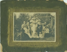
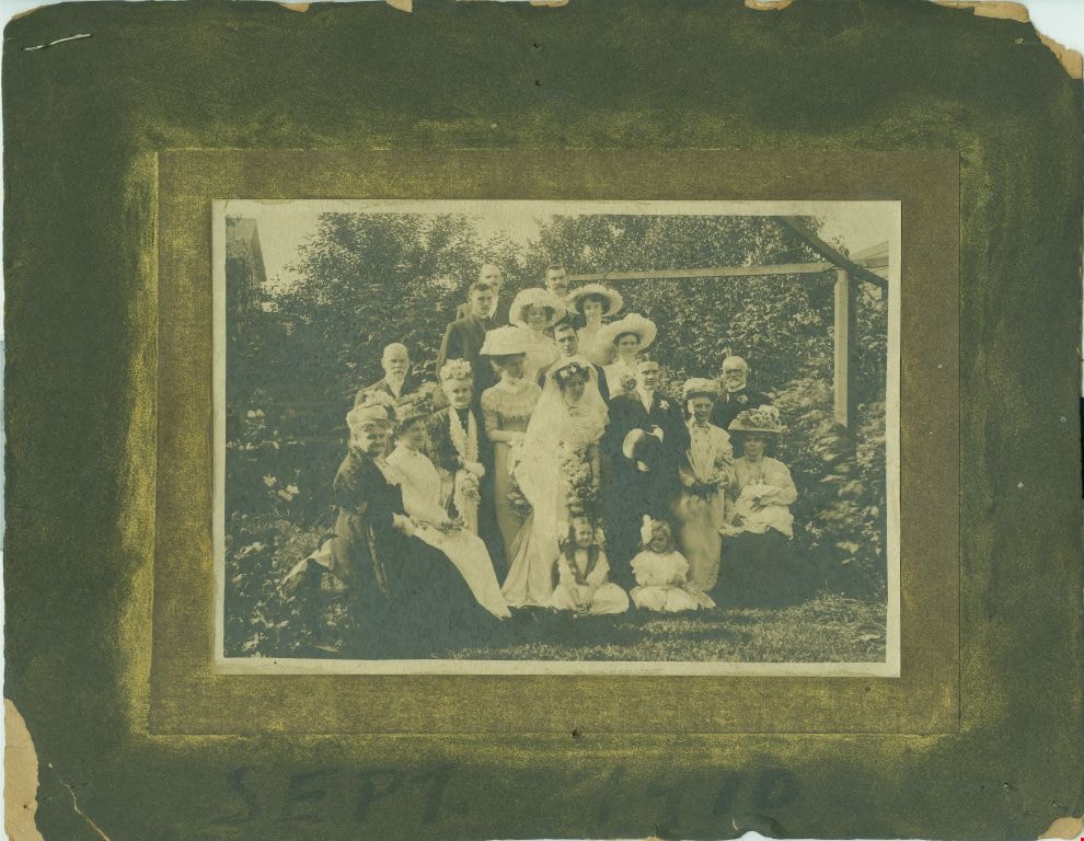
Hawkshaw wedding
https://search.heritageburnaby.ca/link/museumdescription2819
- Repository
- Burnaby Village Museum
- Date
- September 3, 1909
- Collection/Fonds
- Hawkshaw family fonds
- Description Level
- Item
- Physical Description
- 1 photograph : sepia : 10.5 x 16.5 cm, mounted on card ; 20 x 25.5 cm
- Scope and Content
- Photograph of John Edward "Jack" Hawkshaw and Mabel Edith Honor McClean on their wedding day, surrounded by friends and family. The wedding took place at Christ Church Cathedral in Vancouver.
- Repository
- Burnaby Village Museum
- Collection/Fonds
- Hawkshaw family fonds
- Description Level
- Item
- Physical Description
- 1 photograph : sepia : 10.5 x 16.5 cm, mounted on card ; 20 x 25.5 cm
- Scope and Content
- Photograph of John Edward "Jack" Hawkshaw and Mabel Edith Honor McClean on their wedding day, surrounded by friends and family. The wedding took place at Christ Church Cathedral in Vancouver.
- Geographic Access
- Vancouver
- Accession Code
- BV996.6.294
- Access Restriction
- No restrictions
- Reproduction Restriction
- No known restrictions
- Date
- September 3, 1909
- Media Type
- Photograph
- Scan Resolution
- 600
- Scan Date
- 2/24/2011
- Scale
- 100
- Photographer
- Thomson, Stuart
- Notes
- Title based on contents of photograph
- Note in red ink on verso of photograph reads: “Uncle Jack and Aunt Mabel’s Wedding photo”
- Note in blue pen on verso of photograph reads: “John Edward Hawkshaw (groom) / Mabel Edith Honor [sic] McClean (Bride) / Christ Church Cathederal [sic] / Vancouver B.C. / September 1910”
- Stamp on verso of photograph reads: “Thomson” accompanying white writing reads: “319 Pender Street W. Vancouver”
- Note on recto of card mount reads: “Sept. 1910”
- Notes on the photograph state that the date was September 1910 but vital statistic records state that their wedding date was September 3, 1909
Images
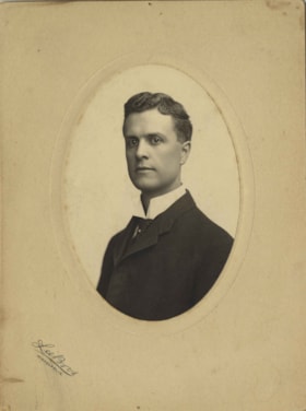
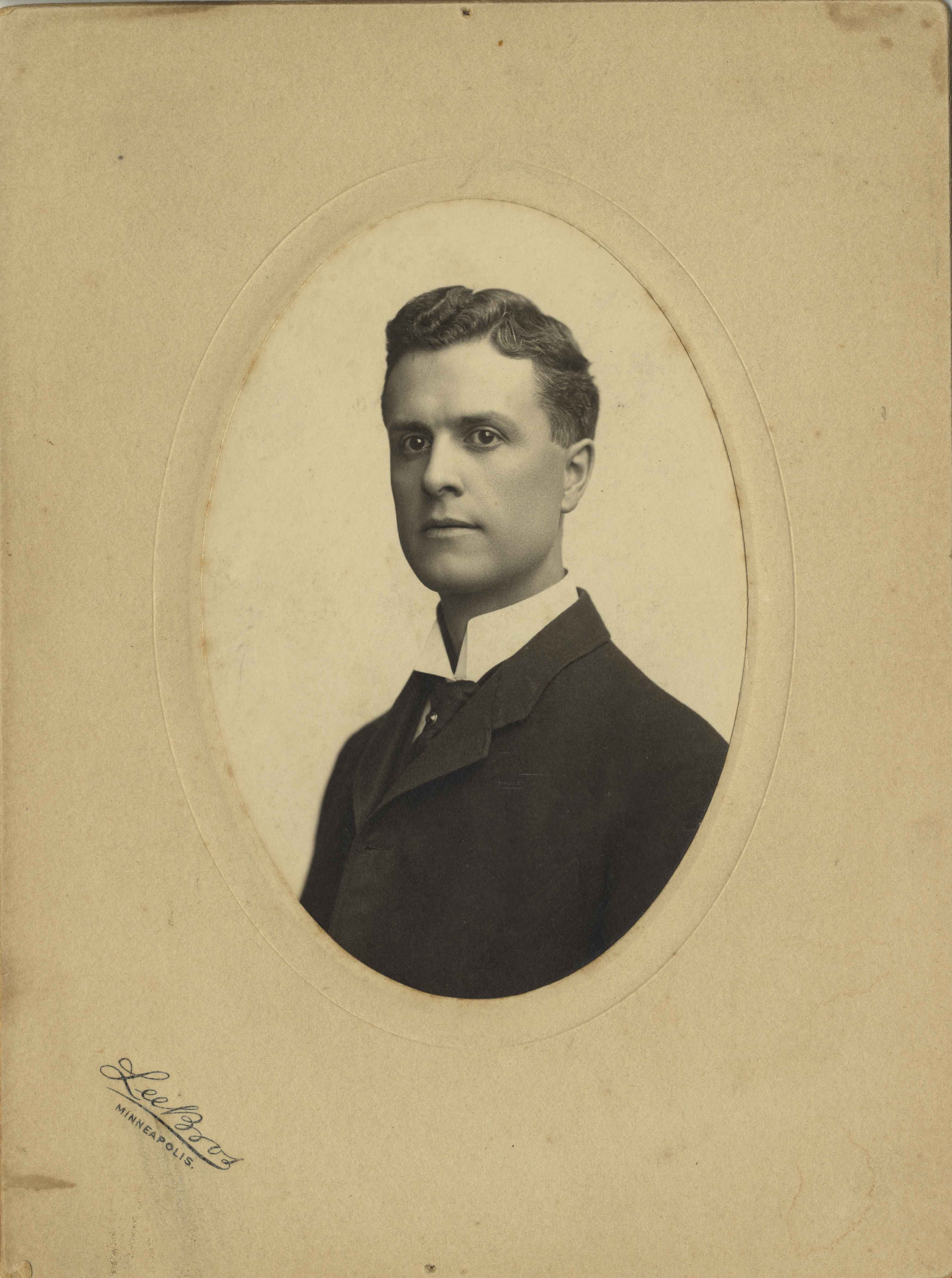
Herbert Penrose Vidal
https://search.heritageburnaby.ca/link/archivedescription82343
- Repository
- City of Burnaby Archives
- Date
- 1904
- Collection/Fonds
- Hill family and Vidal family fonds
- Description Level
- Item
- Physical Description
- 1 photograph : b&w ; 12.5 x 8.5 cm (oval) on cardboard 20 x 15 cm + 1 accompanying page
- Scope and Content
- Photograph is a portrait of a man identified as Herbert Penrose Vidal.
- Repository
- City of Burnaby Archives
- Date
- 1904
- Collection/Fonds
- Hill family and Vidal family fonds
- Physical Description
- 1 photograph : b&w ; 12.5 x 8.5 cm (oval) on cardboard 20 x 15 cm + 1 accompanying page
- Description Level
- Item
- Record No.
- 550-005
- Access Restriction
- No restrictions
- Reproduction Restriction
- No known restrictions
- Accession Number
- 2013-03
- Scope and Content
- Photograph is a portrait of a man identified as Herbert Penrose Vidal.
- Names
- Vidal, Herbert Penrose
- Media Type
- Photograph
- Notes
- Title based on contents of photograph
- Note in black pen on verso reads: "June 1904"
- Note in blue pen on verso reads: "H. P. Vidal"
- Photograph stamp on cardboard reads: "Lee Bros / Minneapolis"
- Note in pencil on album page reads: "Herbert Penrose Vidal / 1866-1934"
Images
![Jane Ann Rollason, [1860-1900] thumbnail](/media/hpo/_Data/_Archives_Images/_Unrestricted/550/550-118.jpg?width=280)
Jane Ann Rollason
https://search.heritageburnaby.ca/link/archivedescription82544
- Repository
- City of Burnaby Archives
- Date
- [1860-1900]
- Collection/Fonds
- Hill family and Vidal family fonds
- Description Level
- Item
- Physical Description
- 1 photograph : sepia ; 9.5 x 6 cm + 1 piece of wood
- Scope and Content
- Photograph is a portrait of a woman identified as Jane Ann Rollason.
- Repository
- City of Burnaby Archives
- Date
- [1860-1900]
- Collection/Fonds
- Hill family and Vidal family fonds
- Physical Description
- 1 photograph : sepia ; 9.5 x 6 cm + 1 piece of wood
- Description Level
- Item
- Record No.
- 550-118
- Access Restriction
- No restrictions
- Reproduction Restriction
- No known restrictions
- Accession Number
- 2013-03
- Scope and Content
- Photograph is a portrait of a woman identified as Jane Ann Rollason.
- Media Type
- Photograph
- Notes
- Title based on note accompanying photograph
- Note in pencil on album page reads: "Jane Ann Rollinson / (wife of Richard Hill) / (Grandmother of Minard Hill)
- Note in pencil on verso reads: "Jane Ann nee Rollison (Hill)"
- Photograph stamp on verso reads: "From the Photographic Studio W Sherwoood, / 23 Nook Street, Workincton, / This or ... can be enlar... in oil or water colours. / Negatives ... always be had"
- Note in blue pen on piece of wood taped to the album page reads: "Mother of K Claude Hill B R Hill / Jane Hill Nee Rolston / Grand Mother of K M Peers"
Images
![Jane Ann Rollason, [1860-1900] thumbnail](/media/hpo/_Data/_Archives_Images/_Unrestricted/550/550-118.jpg)
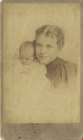
Julia "Jue" Jones Owens and Salter Owens
https://search.heritageburnaby.ca/link/archivedescription82352
- Repository
- City of Burnaby Archives
- Date
- [1906]
- Collection/Fonds
- Hill family and Vidal family fonds
- Description Level
- Item
- Physical Description
- 1 photograph : sepia ; 10.5 x 6.5 cm
- Scope and Content
- Photograph is a portrait of a woman, Julia "Jue" Jones Owens and her son, Salter Owens.
- Repository
- City of Burnaby Archives
- Date
- [1906]
- Collection/Fonds
- Hill family and Vidal family fonds
- Physical Description
- 1 photograph : sepia ; 10.5 x 6.5 cm
- Description Level
- Item
- Record No.
- 550-014
- Access Restriction
- No restrictions
- Reproduction Restriction
- No known restrictions
- Accession Number
- 2013-03
- Scope and Content
- Photograph is a portrait of a woman, Julia "Jue" Jones Owens and her son, Salter Owens.
- Media Type
- Photograph
- Notes
- Title based on caption accompanying photograph
- Note in pencil on verso reads: "Gr. Aunt Jue / Julia & Salter"
- Note in pencil on album page reads: "Aunt Jue / & Son Salter"
- Photograph stamp on recto reads: "Varney / 3937 Drexel Boulevard, / Chicago"
- Photograph stamp on verso reads: "Varney / Chicago"
Images

![Louis Claude Hill's Farm, Burnaby, BC, [1909] thumbnail](/media/hpo/_Data/_BVM_Images/1973/1973_0040_0004_001.jpg?width=280)
Louis Claude Hill's Farm, Burnaby, BC
https://search.heritageburnaby.ca/link/museumdescription3064
- Repository
- Burnaby Village Museum
- Date
- [1909]
- Collection/Fonds
- Burnaby Village Museum Photograph collection
- Description Level
- Item
- Physical Description
- 1 photograph : b&w ; 12.2 x 17.6 cm mounted on cardboard 22.7 x 27.4 cm
- Scope and Content
- Photograph of a farm with men, a horse and wagon, and children in a field. An annotation on the back of one of the photos reads, "The foreground farm property stood at the corner of Sperling Avenue (formerly known as the Pole Line Road) and Buckingham. The white house in the left centre was the …
- Repository
- Burnaby Village Museum
- Collection/Fonds
- Burnaby Village Museum Photograph collection
- Description Level
- Item
- Physical Description
- 1 photograph : b&w ; 12.2 x 17.6 cm mounted on cardboard 22.7 x 27.4 cm
- Scope and Content
- Photograph of a farm with men, a horse and wagon, and children in a field. An annotation on the back of one of the photos reads, "The foreground farm property stood at the corner of Sperling Avenue (formerly known as the Pole Line Road) and Buckingham. The white house in the left centre was the residence of Miss Woodward, her mother and sister. It was the first post office at 'Burnaby Lake' and the site of the kindergarten school of Miss Harriet Woodward. It later became the United Church. / The open field in the distance above the horse's head and people in the field is the field in front of the 'Manor House' which was built by Mr. Bateman in the 1920's. To the right of and beyond the white house partly hidden by the trees can be seen some of the buildings associated with the Hill farm on Deer Lake Ave. which by the date (1909) of this photo had been sold. The distant tall trees (center) stand on the site of the Municipal Buildings (DesBirsays Woods)." An annotation on the back of the other photograph reads, "Formerly belonging to Malcom Nicolson / App. 1908." Annotations at the bottom front of the photograph read, "L. Claude Hill's Farm, Burnaby, BC."
- Subjects
- Agriculture - Crops
- Agricultural Tools and Equipment
- Animals - Horses
- Occupations - Farmers
- Agriculture - Farms
- Geographic Access
- Buckingham Avenue
- Sperling Avenue
- Accession Code
- HV973.40.4
- Access Restriction
- No restrictions
- Reproduction Restriction
- No known restrictions
- Date
- [1909]
- Media Type
- Photograph
- Historic Neighbourhood
- Burnaby Lake (Historic Neighbourhood)
- Planning Study Area
- Morley-Buckingham Area
- Scan Resolution
- 600
- Scan Date
- 2023-05-09
- Scale
- 100
- Notes
- Title based on contents of photograph
- 1 b&w duplicate photograph accompanying
- Text on first image "L Claude Hill's Farm, Burnaby B C", incorporated into the image at the bottom edge of the photograph. "app 1909" pencilled in following above on the bottom edge of the image "L. Claude / Hill / Broadview", pencilled on the matt below the image. "The foreground farm property stood at the / Corner of Sperling Ave. (formerly known as Pole Line Road) / and Buckingham. The white house in the left / centre was the residence of Miss Woodward, her mother / and sister. It was the first post ofice at "Burnaby Lake" / and the site of the kindergarten school of Miss / Harriet Woodward. It later became the United / Church. / The open field in the distance above / the horses head and people in the field is / the field in front of the "Manse House" which / was built by Mr. Bateman in the 1920's. To the / right of and beyond the white house partly hidden / by the trees can be seen some of the buildings / associated with the Hill farm on Deer Lake Ave. / which by the date (1909) of this photo had been / sold. The distant tall trees (center) stand on the site of / the Municipal Buildings (DesBirsays Woods)", hand written in blue ink on the reverse side of the matt. It is not indicated who wrote the note. "OR MASTER / 973.40.4", pencilled in the lower right corner of reverse side of matt. "W. T. COOKSLEY / NEW WESTMINSTER, B.C."printed with very little contrast on the gray mattboard, below the lower right corner of the photograph Text on second image. "L Claude Hill's Farm, Burnaby B C", incorporated into the image at the bottom edge of the photograph. "Claude surveying the haying", pencilled on the reverse side of the matt. "Formerly belonging to Malcolm Nicholson / app 1908", hand writen in blue ink on the reverse side of the matt. "H.V.973.40.4. OR. MASTER", hand printed on the bottom left corner of the reverse side of the matt. "W. T. COOKSLEY / NEW WESTMINSTER, B.C."printed with very little contrast on the gray mattboard, below the lower right corner of the photograph
Images
![Louis Claude Hill's Farm, Burnaby, BC, [1909] thumbnail](/media/hpo/_Data/_BVM_Images/1973/1973_0040_0004_001.jpg)
