postcard; advertisement
https://search.heritageburnaby.ca/link/museumartifact44810
- Repository
- Burnaby Village Museum
- Accession Code
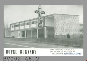
- BV002.48.2
- Description
- Postcard: black and white photo, glossy; horizontal; hotel; white bar across bottom with black "HOTEL BURNABY" "1385 KINGSWAY, N.W., B.C." "ON HIGHWAY NUMBER 99" "TELEPHONE N.W. 4375"; '4375' crossed out and 'LA 18891" written beside it in blue pen; hotel is two-storey building, white with brick and wood accents; parking? below; screen wall at nearest part is full height of building; totem-pole shaped neon sign has vertical "HOTEL", horizontal "Burnaby", and at bottom, "VACANCY", "OFFICE", arrow; on reverse in black "HOTEL BURNABY:" "LOCATED BETWEEN NEW SIMPSONS-SEARS AND NEW WOODWARDS... YOU WILL REMEMBER HOTEL BURNABY FOR THE REST OF YOUR LIFE."; "REST" is in bold type; line down centre; at bottom left, "PRINTED IN CANADA BY PLOWRIGHT PTG."; at upper right, "POST CARD" and outline of rectangle with "PLACE STAMP HERE"; c. late 1950s; unused; pencilled "4-" at top; lightly soiled
- Classification
- Written Communication T&E - - Writing Media
- Object Term
- Postcard
- Colour
- Black
- White
- Maker
- Plowright Printing
- Country Made
- Canada
- Title
- Hotel Burnaby
- Names
- Hotel Burnaby Limited
Images

![Map of proposed provincial exhibition site at Burnaby Lake, [between 1929 and 1931] thumbnail](/media/hpo/_Data/_BVM_Cartographic_Material/2017/2017_0002_0009_005.jpg?width=280)
Map of proposed provincial exhibition site at Burnaby Lake
https://search.heritageburnaby.ca/link/museumdescription8703
- Repository
- Burnaby Village Museum
- Date
- [between 1929 and 1931]
- Collection/Fonds
- Burnaby Village Museum Map collection
- Description Level
- Item
- Physical Description
- 1 map : photostat print ; 3 parts 45 x 33.7 cm totalling 45 x 101 cm
- Scope and Content
- Item consists of a tri-part folding map of a proposed Provincial Exhibition site located along the southern and western shore of Burnaby Lake. Exhibtion site on map identifies proposed locations for a golf course, pier, hydroplane landing ramp, sports ground, one-mile horse racing track and various…
- Repository
- Burnaby Village Museum
- Collection/Fonds
- Burnaby Village Museum Map collection
- Description Level
- Item
- Physical Description
- 1 map : photostat print ; 3 parts 45 x 33.7 cm totalling 45 x 101 cm
- Material Details
- Scale [1:1800]
- Scope and Content
- Item consists of a tri-part folding map of a proposed Provincial Exhibition site located along the southern and western shore of Burnaby Lake. Exhibtion site on map identifies proposed locations for a golf course, pier, hydroplane landing ramp, sports ground, one-mile horse racing track and various buildings for mechanical, agricultural and botanical displays.
- Subjects
- Exhibitions
- Accession Code
- BV017.2.9
- Access Restriction
- No restrictions
- Reproduction Restriction
- No known restrictions
- Date
- [between 1929 and 1931]
- Media Type
- Cartographic Material
- Historic Neighbourhood
- Burnaby Lake (Historic Neighbourhood)
- Planning Study Area
- Burnaby Lake Area
- Scan Resolution
- 400
- Scan Date
- 2021-11-18
- Notes
- Title based on contents of map
- Scale on map reads: "150 feet to 1 inch"
- Overall measurements when fully opened: L: 98.0 cm x H: 45.3 cm ; Individual map parts: L: 32.7 cm x H: 45.0 cm
- Commercially printed label on front of portfolio card reads "PLOWRIGHT PRINTING COMPANY / TELEPHONE N.W. 1942 / 39 McKENZIE STREET NEW WESTMINSTER, B.C. / TO: [illegible writing in pencil]" in blue ink. Red typewritten text reads: "PHOTOSTAT OF BURNABY LAKE".
Images
![Map of proposed provincial exhibition site at Burnaby Lake, [between 1929 and 1931] thumbnail](/media/hpo/_Data/_BVM_Cartographic_Material/2017/2017_0002_0009_005.jpg)


