Narrow Results By

Civic Protocols
https://search.heritageburnaby.ca/link/archivedescription95104
- Repository
- City of Burnaby Archives
- Date
- April 30, 2020
- Collection/Fonds
- Burnaby Photographic Society fonds
- Description Level
- Item
- Physical Description
- 1 photograph (tiff)
- Scope and Content
- Photograph of a marquee at Burnaby North Secondary School that reads "Wash Your Hands Stay 2M Apart".
- Repository
- City of Burnaby Archives
- Date
- April 30, 2020
- Collection/Fonds
- Burnaby Photographic Society fonds
- Physical Description
- 1 photograph (tiff)
- Description Level
- Item
- Record No.
- 623-022
- Access Restriction
- No restrictions
- Reproduction Restriction
- No restrictions
- Accession Number
- 2020-10
- Scope and Content
- Photograph of a marquee at Burnaby North Secondary School that reads "Wash Your Hands Stay 2M Apart".
- Media Type
- Photograph
- Photographer
- King, Gloria
- Notes
- Transcribed title
- Geographic Access
- Hammarskjold Drive
- Street Address
- 751 Hammarskjold Drive
- Planning Study Area
- Parkcrest-Aubrey Area
Images


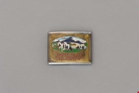
date plaque
https://search.heritageburnaby.ca/link/museumartifact90987
- Repository
- Burnaby Village Museum
- Accession Code
- BV021.11.1
- Description
- Bronze date plaque stamped "F.V.M.P.A./ BURNABY PLANT SOD TURNING / JULY 26, 1962" with 4 corner holes. The object has scratches throughout. The plaque is taped to a cardboard tag with the text "B5102 / $0.80"
- Object History
- The plate is to commemorate the Fraser Valley Milk Producers Assocation Burnaby Plant sod turning ceremony on July 26, 1962, when construction started on the new facility at Sperling and Lougheed. The plant opened in 1964, and housed the FVMPA head offices, fluid milk plant, and ice cream manufacturing division.
- Category
- 08. Communication Artifacts
- Classification
- Documentary Artifacts - - Other Documents
- Object Term
- Plate, Identification
- Measurements
- 6.3cm wide x 3.1cm high
- Subjects
- Foods
- Agriculture
- Agriculture - Dairy
- Historic Neighbourhood
- Lozells (Historic Neighbourhood)
- Planning Study Area
- Government Road Area
Images


Deer Lake
https://search.heritageburnaby.ca/link/archivedescription91707
- Repository
- City of Burnaby Archives
- Date
- 1994-1996
- Collection/Fonds
- Doreen Lawson fonds
- Description Level
- File
- Physical Description
- 55 photographs : col. slides ; 35 mm
- Scope and Content
- File consists of scenic photographs of Deer Lake and Deer Lake Park, including closeup photographs of the lake and landscape photographs with the lake in the foreground and mountains and skyline visible in the distance. The photographs capture Deer Lake in the fall, winter, and spring. Also inclu…
- Repository
- City of Burnaby Archives
- Date
- 1994-1996
- Collection/Fonds
- Doreen Lawson fonds
- Physical Description
- 55 photographs : col. slides ; 35 mm
- Description Level
- File
- Record No.
- 618-025
- Access Restriction
- No restrictions
- Reproduction Restriction
- No restrictions
- Accession Number
- 2015-15
- Scope and Content
- File consists of scenic photographs of Deer Lake and Deer Lake Park, including closeup photographs of the lake and landscape photographs with the lake in the foreground and mountains and skyline visible in the distance. The photographs capture Deer Lake in the fall, winter, and spring. Also included in the file are four photographs of Deer Lake Park signs.
- Subjects
- Natural Phenomena - Snow
- Geographic Features - Lakes and Ponds
- Plants - Trees
- Geographic Features - Mountains
- Advertising Medium - Signs and Signboards
- Names
- Burnaby Art Gallery
- Media Type
- Photograph
- Photographer
- Lawson, Doreen A.
- Notes
- Title based on contents of photographs
- Geographic Access
- Deer Lake
- Historic Neighbourhood
- Burnaby Lake (Historic Neighbourhood)
- Planning Study Area
- Oakalla Area
Images

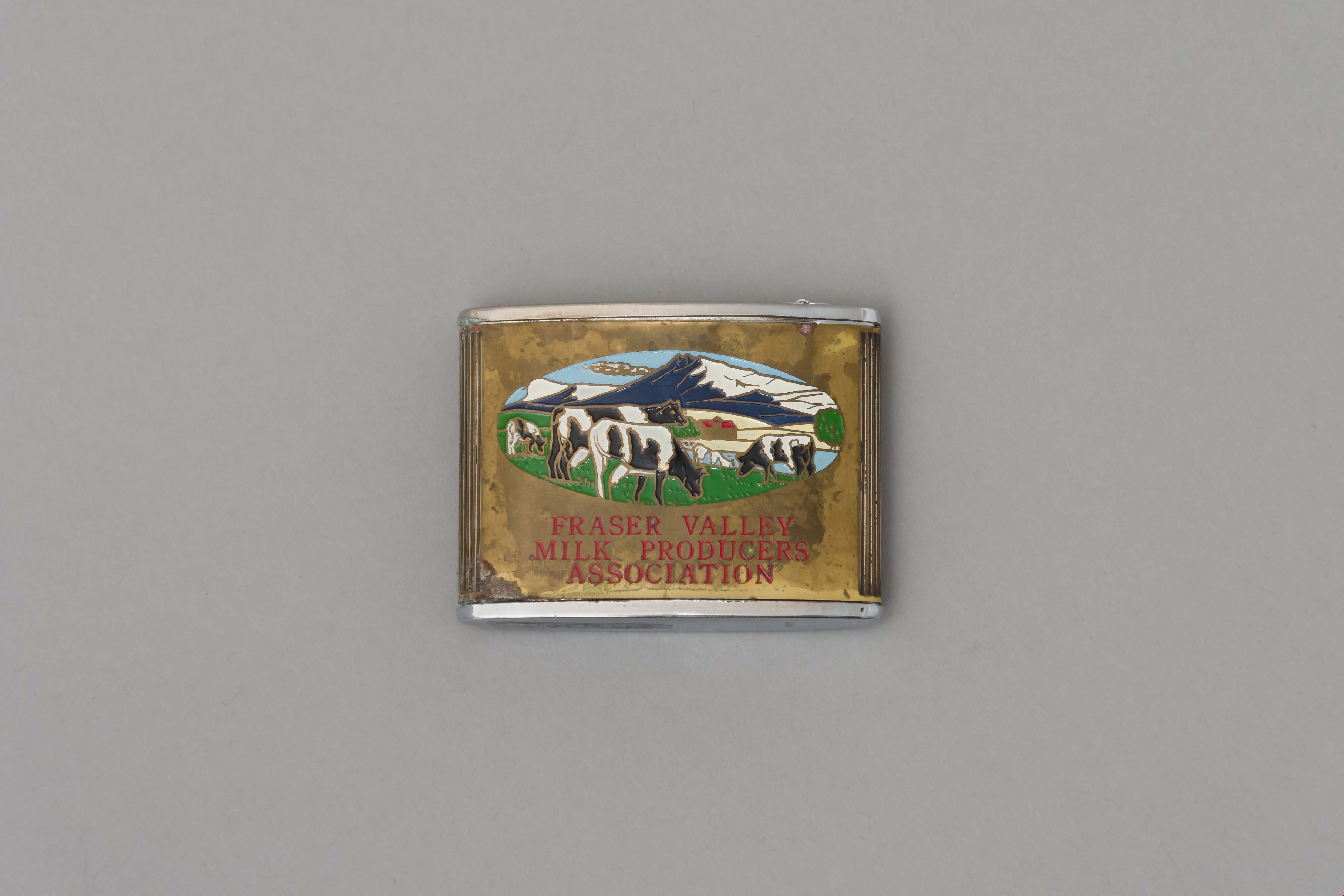
tape measure
https://search.heritageburnaby.ca/link/museumartifact90960
- Repository
- Burnaby Village Museum
- Accession Code
- BV021.10.1
- Description
- Promitional tape measurer with a silver top plates and a gold body engraved on both sides. One side dark blue with ariel drawing of building and "Dairyland/ BURNABY PLANT/ 1964" engraved. Reverse is oval image of 4 cows in a field with mountains, sky, and a barn painted on a gold body with "FRASER VALLEY/ MILK PRODUCERS/ ASSOCIATION" in red. Top has a retractable silver steel tape with measurements in inches on one side. "Japan" engraved on base.
- Object History
- This object belonged to a sales representative for Dairyland, who lived in Chilliwack. He retired in 1978 after 40 years with the company. The Burnaby Dairyland plant was constructed in 1964 on Lougheed Highway near Sperling Avenue.
- Reference
- http://www.bcdairyhistory.ca/milk-break/magazine/1964-fraser-valley-milk-break.pdf
- Classification
- Weights and Measurements Tools and Equipment - Scales
- Object Term
- Retractable Rule, Tape Measure
- Marks/Labels
- "Dairyland Burnaby Plant 1964", "Fraser Valley Milk Producers Association" "Japan"
- Measurements
- 4cm high x 5cm wide
- Subjects
- Foods
- Agriculture
- Agriculture - Dairy
- Historic Neighbourhood
- Lozells (Historic Neighbourhood)
- Planning Study Area
- Government Road Area
Images