Narrow Results By
Subject
- Agriculture - Fruit and Berries 1
- Armament - Munitions 1
- Buildings - Commercial 2
- Buildings - Commercial - Grocery Stores 2
- Buildings Components - Fireplaces 2
- Buildings - Heritage 2
- Buildings - Industrial 1
- Buildings - Industrial - Refineries 3
- Buildings - Residential - Houses 1
- Ceremonies - Weddings 2
- Elections 1
- Events 3

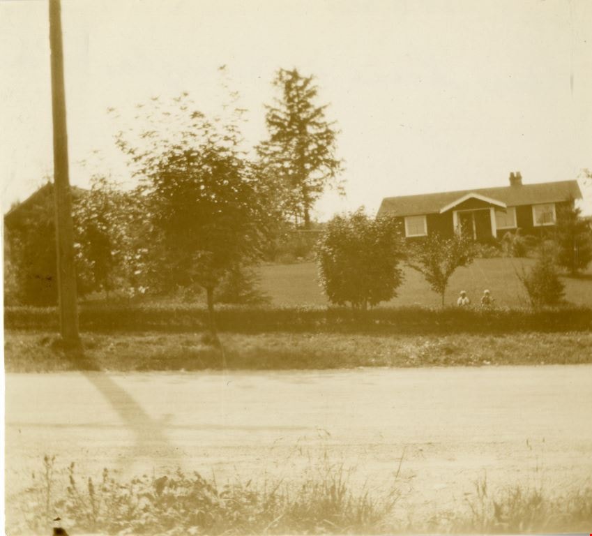
Looking west from Douglas Road
https://search.heritageburnaby.ca/link/archivedescription91827
- Repository
- City of Burnaby Archives
- Date
- September 1934
- Collection/Fonds
- Small family fonds
- Description Level
- Item
- Physical Description
- 1 photograph : sepia ; 7.5 cm x 8.5 cm
- Scope and Content
- Photograph of the Roberts' house on 5118 Douglas Road, taken from across the street. Edward and Roland Roberts are seated on the lawn behind a hedge and in front of the house. To the left is the house located at 5106 Douglas Road, built by John W. Roberts and then subsequently sold.
- Repository
- City of Burnaby Archives
- Date
- September 1934
- Collection/Fonds
- Small family fonds
- Physical Description
- 1 photograph : sepia ; 7.5 cm x 8.5 cm
- Description Level
- Item
- Record No.
- 620-008
- Access Restriction
- No restrictions
- Reproduction Restriction
- No known restrictions
- Accession Number
- 2017-01
- Scope and Content
- Photograph of the Roberts' house on 5118 Douglas Road, taken from across the street. Edward and Roland Roberts are seated on the lawn behind a hedge and in front of the house. To the left is the house located at 5106 Douglas Road, built by John W. Roberts and then subsequently sold.
- Media Type
- Photograph
- Notes
- Transcribed title
- Title transcribed from donor's notes
- 5118 Douglas Road renumbered to 3131 Douglas Road in 1958 and to 5538 Dominion Street in 1970 or 1971
- 5106 Douglas Road later subdivided into 5539 and 5545 Norfolk Street.
- Note in black ink on verso of photograph reads: "Sept. 1934 / Our house on Douglas Road"
- Note in blue ink on verso of photograph reads: "P9"
- Street Address
- 3131 Douglas Road
- 5118 Douglas Road
- 5538 Dominion Street
- 5106 Douglas Road
- Historic Neighbourhood
- Burnaby Lake (Historic Neighbourhood)
- Planning Study Area
- Ardingley-Sprott Area
Images
![Louise Irwin at Barnet, [1930] (date of original), copied 2004 thumbnail](/media/hpo/_Data/_BVM_Images/2019/2019_0032_0082_001.jpg?width=280)
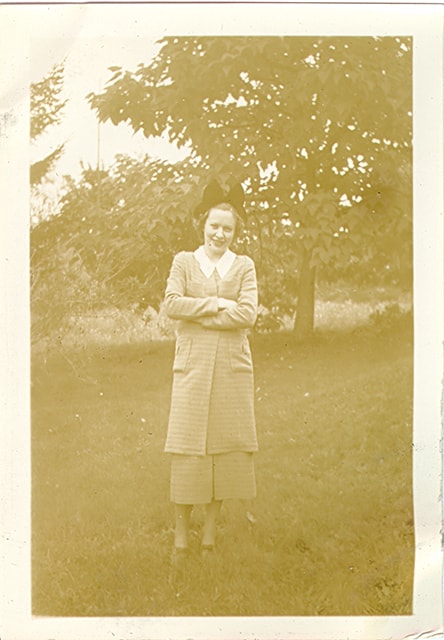
Louise Irwin at Barnet
https://search.heritageburnaby.ca/link/museumdescription15263
- Repository
- Burnaby Village Museum
- Date
- [1930] (date of original), copied 2004
- Collection/Fonds
- In the Shadow by the Sea collection
- Description Level
- Item
- Physical Description
- 1 photograph (tiff) : 300 dpi
- Scope and Content
- Photograph of young Louise Irwin standing under a tree in the yard of the Irwin family home at Barnet Lumber Mill. The house is visible behind her.
- Repository
- Burnaby Village Museum
- Collection/Fonds
- In the Shadow by the Sea collection
- Description Level
- Item
- Physical Description
- 1 photograph (tiff) : 300 dpi
- Scope and Content
- Photograph of young Louise Irwin standing under a tree in the yard of the Irwin family home at Barnet Lumber Mill. The house is visible behind her.
- History
- Henry Stanley Irwin (1890-1966) started work at Barnet mill in 1924. Henry and his wife Elsie May Irwin (Taylor) Irwin (1894-1985) first lived with thier two daughters, Eleanor (Nelson) (1924-2005) and Louise (1927-) in a worker's cabin before moving to the Barnet Mill's managers' residence. The household included Elsie's mother, Elizabeth (Shephard) Taylor (1868-1950). The family resided at Barnet until they moved to Vancouver in September 1939. Louise and her older sister Eleanor attended Barnet School like other children in the Barnet area. After the mill closed in 1931, Henry was unemployed for two years, during this time, he hired a horse and driver and cut logs from the slopes of Burnaby Mountain to support his family.
- Subjects
- Plants - Trees
- Geographic Access
- Burrard Inlet
- Accession Code
- BV019.32.82
- Access Restriction
- No restrictions
- Reproduction Restriction
- No known restrictions
- Date
- [1930] (date of original), copied 2004
- Media Type
- Photograph
- Historic Neighbourhood
- Barnet (Historic Neighbourhood)
- Planning Study Area
- Burnaby Mountain Area
- Notes
- Title based on contents of photograph
Images
![Louise Irwin at Barnet, [1930] (date of original), copied 2004 thumbnail](/media/hpo/_Data/_BVM_Images/2019/2019_0032_0082_001.jpg)
![Louise Irwin in cherry tree, [1936] (date of original), copied 2004 thumbnail](/media/hpo/_Data/_BVM_Images/2019/2019_0032_0098_001.jpg?width=280)
Louise Irwin in cherry tree
https://search.heritageburnaby.ca/link/museumdescription15281
- Repository
- Burnaby Village Museum
- Date
- [1936] (date of original), copied 2004
- Collection/Fonds
- In the Shadow by the Sea collection
- Description Level
- Item
- Physical Description
- 1 photograph (tiff) : 300 dpi
- Scope and Content
- Photograph of Louise Irwin standing on a limb of a cherry tree in the yard of the Irwin family home on the site of the Barnet Lumber Mill. The cherry tree is in full bloom with cherry blossoms.
- Repository
- Burnaby Village Museum
- Collection/Fonds
- In the Shadow by the Sea collection
- Description Level
- Item
- Physical Description
- 1 photograph (tiff) : 300 dpi
- Scope and Content
- Photograph of Louise Irwin standing on a limb of a cherry tree in the yard of the Irwin family home on the site of the Barnet Lumber Mill. The cherry tree is in full bloom with cherry blossoms.
- History
- Henry Stanley Irwin (1890-1966) started work at Barnet mill in 1924. Henry and his wife Elsie May Irwin (Taylor) Irwin (1894-1985) first lived with their two daughters, Eleanor (Nelson) (1924-2005) and Louise (1927-) in a worker's cabin before moving to the Barnet Mill's managers' residence. The household included Elsie's mother, Elizabeth (Shephard) Taylor (1868-1950). The family resided at Barnet until they moved to Vancouver in September 1939. Louise and her older sister Eleanor attended Barnet School like other children in the Barnet area. After the mill closed in 1931, Henry was unemployed for two years, during this time, he hired a horse and driver and cut logs from the slopes of Burnaby Mountain to support his family.
- Geographic Access
- Burrard Inlet
- Accession Code
- BV019.32.98
- Access Restriction
- No restrictions
- Reproduction Restriction
- No known restrictions
- Date
- [1936] (date of original), copied 2004
- Media Type
- Photograph
- Historic Neighbourhood
- Barnet (Historic Neighbourhood)
- Planning Study Area
- Burnaby Mountain Area
- Notes
- Title based on contents of photograph
Images
![Louise Irwin in cherry tree, [1936] (date of original), copied 2004 thumbnail](/media/hpo/_Data/_BVM_Images/2019/2019_0032_0098_001.jpg)
![Louise with cherry blossoms, [1937] (date of original), copied 2004 thumbnail](/media/hpo/_Data/_BVM_Images/2019/2019_0032_0095_001.jpg?width=280)
Louise with cherry blossoms
https://search.heritageburnaby.ca/link/museumdescription15278
- Repository
- Burnaby Village Museum
- Date
- [1937] (date of original), copied 2004
- Collection/Fonds
- In the Shadow by the Sea collection
- Description Level
- Item
- Physical Description
- 1 photograph (tiff) : 300 dpi
- Scope and Content
- Photograph of Louise Irwin standing under a cherry tree that is in full bloom with cherry blossoms. The tree is in the yard of the Irwin family home on the site of the Barnet Lumber Mill.
- Repository
- Burnaby Village Museum
- Collection/Fonds
- In the Shadow by the Sea collection
- Description Level
- Item
- Physical Description
- 1 photograph (tiff) : 300 dpi
- Scope and Content
- Photograph of Louise Irwin standing under a cherry tree that is in full bloom with cherry blossoms. The tree is in the yard of the Irwin family home on the site of the Barnet Lumber Mill.
- History
- Henry Stanley Irwin (1890-1966) started work at Barnet mill in 1924. Henry and his wife Elsie May Irwin (Taylor) Irwin (1894-1985) first lived with thier two daughters, Eleanor (Nelson) (1924-2005) and Louise (1927-) in a worker's cabin before moving to the Barnet Mill's managers' residence. The household included Elsie's mother, Elizabeth (Shephard) Taylor (1868-1950). The family resided at Barnet until they moved to Vancouver in September 1939. Louise and her older sister Eleanor attended Barnet School like other children in the Barnet area. After the mill closed in 1931, Henry was unemployed for two years, during this time, he hired a horse and driver and cut logs from the slopes of Burnaby Mountain to support his family.
- Geographic Access
- Burrard Inlet
- Accession Code
- BV019.32.95
- Access Restriction
- No restrictions
- Reproduction Restriction
- No known restrictions
- Date
- [1937] (date of original), copied 2004
- Media Type
- Photograph
- Historic Neighbourhood
- Barnet (Historic Neighbourhood)
- Planning Study Area
- Burnaby Mountain Area
- Notes
- Title based on contents of photograph
Images
![Louise with cherry blossoms, [1937] (date of original), copied 2004 thumbnail](/media/hpo/_Data/_BVM_Images/2019/2019_0032_0095_001.jpg)
Love family fonds
https://search.heritageburnaby.ca/link/museumdescription10098
- Repository
- Burnaby Village Museum
- Date
- 1881-1971
- Collection/Fonds
- Love family fonds
- Description Level
- Fonds
- Physical Description
- 11 cm of textual records + 44 photographs + 5 plans
- Scope and Content
- Fonds consists of family records including photographs, land sale records, agreements and plans as well as estate records, vital event documentation and correspondence. Records pertain to members of the Love family including the Parkers, Hughes and Leonards. Fonds has been arranged in the followin…
- Repository
- Burnaby Village Museum
- Collection/Fonds
- Love family fonds
- Description Level
- Fonds
- Physical Description
- 11 cm of textual records + 44 photographs + 5 plans
- Scope and Content
- Fonds consists of family records including photographs, land sale records, agreements and plans as well as estate records, vital event documentation and correspondence. Records pertain to members of the Love family including the Parkers, Hughes and Leonards. Fonds has been arranged in the following series: 1) Love and Leonard land records 2) Love family vital events and correspondence 3) Love family photographs
- History
- Jesse Love was born in Swindon, England in 1847 and left England to work on a dairy farm in the Toronto area. While working on the farm in Toronto, he met Martha Leonard who he married in 1879. Martha was born on February 3, 1858 in Bedfordshire, England and had come to Canada with her parents George and Ann Leonard. While living in Toronto, Jesse and Martha had two children, George born March 22, 1880 and Annie Elizabeth on August 24, 1881. About one year after Annie was born, the Love family moved to North Dakota to grow wheat. While living there, they had two more children, Henry who was born August 24, 1883 and Edith Minnie born October 9, 1885. The family decided to move further west after hearing about the fairer weather conditions from Martha’s father, George Leonard, who had settled in Vancouver in 1885. On May 23, 1887, Jesse, Martha and their four children arrived in Vancouver after travelling across Canada from Winnipeg on the first transcontinental train. The Loves made their home in Vancouver while Jesse helped clear land on Granville Street. Their fifth child, Thomas Robert was born on September 17, 1887 and soon after, the family moved to Lulu Island in Richmond where they lived growing vegetables and selling them to Vancouver hotels. While living and farming on Lulu island, the couple had two more girls, Martha (Dot or Dorothy) born on December 17, 1889 and Sarah Marie, born February 8, 1892. On October 6, 1893 an agreement was signed by Jesse Love to purchase 14.52 acres of land from Joseph C. Armstrong. The acreage covered the north east section of District Lot 25 within the newly incorporated District of the Municipality of Burnaby. It was here where the original Love house was built (between October 1893 and April 15, 1894) by Jesse Love with the help of local builder George Salt and father in law, George Leonard. The house consisted of an entrance hall, dining room, lean to kitchen, master bedroom and three bedrooms upstairs. A road was constructed and named Cumberland in 1905 and ran from District Lot 25 through to District Lot 11. The address for the Love home was 1390 Cumberland Road and in the early 1960’s the address was renumbered 7651 Cumberland Street. On the land surrounding the house, Jesse Love planted an orchard along with strawberries and raspberries which he sold at the Fraser Valley Market, T.S. Anandale’s Grocery Store in New Westminster and to hotels around Vancouver. Jesse Love served on the Burnaby School Board and also as a District Councillor in 1901 and from 1904-1907. While living in the house, Jesse and Martha had four more children, Phoebe Leonard, born April 15, 1894, Esther, born August 28, 1896, John Leonard, born June 7, 1899 and Hannah Victoria (also known as Girlie) who was born May 12, 1902. In 1918, at the age of 31 years, Thomas Robert Love fell ill due to an influenza epidemic and died on November 23, 1918. Following their son’s death, Martha Love became weak and on August 24, 1920, she passed away. By this time, Jesse had sold off a large percentage of his land and his youngest daughter, Girlie decided to stay on to live and care for him. Since the house was too large for just the two of them, Jesse invited any other children to return and share the residence. For a while his son, George and his wife joined them. In 1925 Jesse’s daughter Sarah Parker (nee Love), her husband William Michael Norton Parker and their three children, Albert “Bert” (1915-2011), William Charles “Bill” and Elsie Roberta moved from their home at 1319 Newcombe Street to join Jesse and Girlie in the Love family home on Cumberland. Jesse Love died in 1928 after which Sarah and William Parker purchased the Love family farmhouse and property. William Michael Parker, died in 1961 and Sarah Parker continued to live in the Love family farmhouse until 1966 when she sold it to her daughter Elsie and husband John Hughes. Elsie and John Hughes had four children, John Jr., Ann, Brent and Merle. The Hughes lived in the Love family house until August 1971. In 1988 the Love family farmhouse house was donated to the Burnaby Village Museum and moved to the site of Burnaby Village Museum. The interior of the main floor and exterior of the house went through an extensive restoration process. In 1997, restoration of the kitchen was completed and opened to the public. After the completion of the hallway, dining room, main floor bedroom and parlour, the Love farmhouse exhibit opened on November 29, 1998 with an open invitation to the public and extended members of the Love family.
- Responsibility
- Love Family
- Accession Code
- HV979.40
- BV985.3136
- BV988.45
- BV989.3
- BV992.15
- BV992.26
- BV992.34
- BV000.45
- BV008.20
- BV012.31
- BV019.3
- BV019.8
- Date
- 1881-1971
- Media Type
- Textual Record
- Photograph
- Cartographic Material
- Arrangement
- Fonds has been arranged by record type and original order provided by members of the Love family.
- Notes
- Title based on contents of fonds
- See also Burnaby Village Museum fonds - Jesse Love farmhouse series

Marg Waite
https://search.heritageburnaby.ca/link/museumdescription2708
- Repository
- Burnaby Village Museum
- Date
- August 29, 1937
- Collection/Fonds
- Hawkshaw family fonds
- Description Level
- Item
- Physical Description
- 1 photograph : sepia ; 9 x 6.5 cm
- Scope and Content
- Photograph of Marg Waite standing on the lawn of the house located at 3908 Deer Lake Avenue (6504 Deer Lake Avenue) in Burnaby. A maple tree is visible in the background. Mabel Hawkshaw was living in R.F. Anderson house at this location in 1937.
- Repository
- Burnaby Village Museum
- Collection/Fonds
- Hawkshaw family fonds
- Description Level
- Item
- Physical Description
- 1 photograph : sepia ; 9 x 6.5 cm
- Scope and Content
- Photograph of Marg Waite standing on the lawn of the house located at 3908 Deer Lake Avenue (6504 Deer Lake Avenue) in Burnaby. A maple tree is visible in the background. Mabel Hawkshaw was living in R.F. Anderson house at this location in 1937.
- Names
- Waite, Marg
- Geographic Access
- Deer Lake Avenue
- Accession Code
- BV996.6.140
- Access Restriction
- No restrictions
- Reproduction Restriction
- No known restrictions
- Date
- August 29, 1937
- Media Type
- Photograph
- Historic Neighbourhood
- Burnaby Lake (Historic Neighbourhood)
- Planning Study Area
- Morley-Buckingham Area
- Scan Resolution
- 600
- Scan Date
- 2/18/2010
- Scale
- 100
- Notes
- Title based on contents of photograph
- Caption for photograph reads: "Marg Waite / Aug 29/37"
- Note in pencil on verso of photograph reads: "Aug 29/37 "
- Photograph is part of photograph album BV996.6.1
Images
![Mark VIII anti-aircraft naval gun, [before 1946] thumbnail](/media/hpo/_Data/_BVM_Images/2000/200300460002.jpg?width=280)
Mark VIII anti-aircraft naval gun
https://search.heritageburnaby.ca/link/museumdescription1735
- Repository
- Burnaby Village Museum
- Date
- [before 1946]
- Collection/Fonds
- Burnaby Village Museum Photograph collection
- Description Level
- Item
- Physical Description
- 1 photograph : b&w ; 11 x 16.5 cm
- Scope and Content
- Photograph of fourteen unidentified men in suits standing behind a gun put up on a wooden pedestal, with a sign that reads, "This Gun is the First Mark VIII Anti-Aircraft Naval Gun Produced Outside England/ Athorities acknowledge this is one of the most difficult guns to make/ Initial production at…
- Repository
- Burnaby Village Museum
- Collection/Fonds
- Burnaby Village Museum Photograph collection
- Description Level
- Item
- Physical Description
- 1 photograph : b&w ; 11 x 16.5 cm
- Scope and Content
- Photograph of fourteen unidentified men in suits standing behind a gun put up on a wooden pedestal, with a sign that reads, "This Gun is the First Mark VIII Anti-Aircraft Naval Gun Produced Outside England/ Athorities acknowledge this is one of the most difficult guns to make/ Initial production at this time is an achievement for the men and women of this plant who have set up the first milestone in gun armament in Western Canada/ Our task now is to speed production and built into these guns quality and accuracy that we may be proud of their performance." The company that produced this gun is believed to be the Dominion Bridge Company, at its Western Canada branch (possibly Burnaby). Plywood sheets propped up behind the men help to prevent the location from being identified.
- Subjects
- Armament - Munitions
- Names
- Dominion Bridge Company
- Accession Code
- BV003.46.2
- Access Restriction
- No restrictions
- Reproduction Restriction
- No known restrictions
- Date
- [before 1946]
- Media Type
- Photograph
- Scan Resolution
- 600
- Scan Date
- 09-Jun-09
- Scale
- 100
- Notes
- Stamp on verso of photograph reads: "Publication or circulation forbidden / PERSONNEL DEPT. D. B. CO. LTD. Received."
Images
![Mark VIII anti-aircraft naval gun, [before 1946] thumbnail](/media/hpo/_Data/_BVM_Images/2000/200300460002.jpg)
![Mr. Irwin with Eleanor, Louise and Dorothy on ladder, [1930] (date of original), copied 2004 thumbnail](/media/hpo/_Data/_BVM_Images/2019/2019_0032_0076_001.jpg?width=280)
Mr. Irwin with Eleanor, Louise and Dorothy on ladder
https://search.heritageburnaby.ca/link/museumdescription15257
- Repository
- Burnaby Village Museum
- Date
- [1930] (date of original), copied 2004
- Collection/Fonds
- In the Shadow by the Sea collection
- Description Level
- Item
- Physical Description
- 1 photograph (tiff) : 300 dpi
- Scope and Content
- Photograph of Mr. Henry Irwin standing at the bottom of a ladder holding his daughter Eleanor and Louise Irwin and his neice Dorothy Irwin. Young Louise Irwin is standing near the top of the ladder, Dorothy Irwin is in the middle and Eleanor Irwin (Nelson) is near the bottom. The girls are picking …
- Repository
- Burnaby Village Museum
- Collection/Fonds
- In the Shadow by the Sea collection
- Description Level
- Item
- Physical Description
- 1 photograph (tiff) : 300 dpi
- Scope and Content
- Photograph of Mr. Henry Irwin standing at the bottom of a ladder holding his daughter Eleanor and Louise Irwin and his neice Dorothy Irwin. Young Louise Irwin is standing near the top of the ladder, Dorothy Irwin is in the middle and Eleanor Irwin (Nelson) is near the bottom. The girls are picking cherries. The ladder is leaning against a cherry tree in the yard of the Irwin family home at Barnet mill.
- History
- Henry Stanley Irwin (1890-1966) started work at Barnet mill in 1924. Henry and his wife Elsie May Irwin (Taylor) Irwin (1894-1985) first lived with thier two daughters, Eleanor (Nelson) (1924-2005) and Louise (1927-) in a worker's cabin before moving to the Barnet Mill's managers' residence. The household included Elsie's mother, Elizabeth (Shephard) Taylor (1868-1950). The family resided at Barnet until they moved to Vancouver in September 1939. Louise and her older sister Eleanor attended Barnet School like other children in the Barnet area. After the mill closed in 1931, Henry was unemployed for two years, during this time, he hired a horse and driver and cut logs from the slopes of Burnaby Mountain to support his family.
- Geographic Access
- Burrard Inlet
- Accession Code
- BV019.32.76
- Access Restriction
- No restrictions
- Reproduction Restriction
- No known restrictions
- Date
- [1930] (date of original), copied 2004
- Media Type
- Photograph
- Historic Neighbourhood
- Barnet (Historic Neighbourhood)
- Planning Study Area
- Burnaby Mountain Area
- Notes
- Title based on contents of photograph
- see page 47 of book "In the Shadow by the Sea: Recollections of Burnaby's Barnet Village" with caption "Picking cherries at Barnet. Top to Bottom: Louise Irwin, Cousin Dorothy Irwin, Eleanor Irwin and Mr. Irwin, 1929"
- Date of photograph based on birth date for Louise Irwin (July 1927)
Images
![Mr. Irwin with Eleanor, Louise and Dorothy on ladder, [1930] (date of original), copied 2004 thumbnail](/media/hpo/_Data/_BVM_Images/2019/2019_0032_0076_001.jpg)
Nichols Chemical Company fonds
https://search.heritageburnaby.ca/link/museumdescription18755
- Repository
- Burnaby Village Museum
- Date
- 1906-1962
- Collection/Fonds
- Nichols Chemical Company fonds
- Description Level
- Fonds
- Physical Description
- 9 technical drawings
- Scope and Content
- Fonds consists of technical drawings of the Nichols Chemcial Company plant and machinery.
- Repository
- Burnaby Village Museum
- Collection/Fonds
- Nichols Chemical Company fonds
- Description Level
- Fonds
- Physical Description
- 9 technical drawings
- Scope and Content
- Fonds consists of technical drawings of the Nichols Chemcial Company plant and machinery.
- History
- In 1905 the Nichols Chemical Company, acid manufacturers based in Montreal, established their chemical plant on on a tract of land along Burrard Inlet, just east of the North Pacific Lumber Company. This company was later amalgamated and acquired by General Chemical and remains in operation on the original waterfront site. Many of workers at the Nichols Chemical Plant lived in bunkhouses in the community of Barnet including Japanese Canadian families who were employed there. Many of these families were laid off and forcibily removed during the internment of the Japanese in British Columbia during World War II.
- Creator
- Nichols Chemical Company Limited
- Accession Code
- BV998.23
- Date
- 1906-1962
- Media Type
- Technical Drawing
- Notes
- Title based on contents of fonds
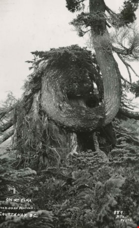
On Mt. Elma
https://search.heritageburnaby.ca/link/archivedescription51453
- Repository
- City of Burnaby Archives
- Date
- 1938
- Collection/Fonds
- Burnaby Historical Society fonds
- Description Level
- Item
- Physical Description
- 1 photograph : b&w postcard ; 13 x 8 cm, mounted on heavy-weight paper 17.5 x 26.5 cm
- Scope and Content
- Photographic postcard of a nursing tree growing out of a stump on Mount Elma. This was part of a trip to the Forbidden Plateau on Vancouver Island made by a small party of City of Courtenay officials. George A. Grant was one of the climbers in the party.
- Repository
- City of Burnaby Archives
- Date
- 1938
- Collection/Fonds
- Burnaby Historical Society fonds
- Subseries
- George Grant subseries
- Physical Description
- 1 photograph : b&w postcard ; 13 x 8 cm, mounted on heavy-weight paper 17.5 x 26.5 cm
- Description Level
- Item
- Record No.
- 243-058
- Access Restriction
- No restrictions
- Reproduction Restriction
- No known restrictions
- Accession Number
- BHS1990-06
- Scope and Content
- Photographic postcard of a nursing tree growing out of a stump on Mount Elma. This was part of a trip to the Forbidden Plateau on Vancouver Island made by a small party of City of Courtenay officials. George A. Grant was one of the climbers in the party.
- Subjects
- Plants - Trees
- Media Type
- Photograph
- Photographer
- Tait, Preston L.
- Notes
- Continuation of title: "...Forbidden Plateau - Courtenay, B.C."
- Handwritten note on facing page reads: "On Mount Elma 4700 ft. where we first saw the real snow."
- Photographer identifies photograph as no. 889
Images

Permission to Plant Trees on Boulevard of 3131 Grandview Highway
https://search.heritageburnaby.ca/link/councilreport65000
- Repository
- City of Burnaby Archives
- Report ID
- 56200
- Meeting Date
- 25-Aug-1930
- Format
- Council - Committee Report
- Collection/Fonds
- City Council and Office of the City Clerk fonds
- Repository
- City of Burnaby Archives
- Report ID
- 56200
- Meeting Date
- 25-Aug-1930
- Format
- Council - Committee Report
- Collection/Fonds
- City Council and Office of the City Clerk fonds
Documents
Permit to Plant Trees on Boulevard of 399 Ellesmere and 201 Ellesmere Avenue
https://search.heritageburnaby.ca/link/councilreport64895
- Repository
- City of Burnaby Archives
- Report ID
- 56071
- Meeting Date
- 28-Jul-1930
- Format
- Council - Committee Report
- Collection/Fonds
- City Council and Office of the City Clerk fonds
- Repository
- City of Burnaby Archives
- Report ID
- 56071
- Meeting Date
- 28-Jul-1930
- Format
- Council - Committee Report
- Collection/Fonds
- City Council and Office of the City Clerk fonds
Documents
Recommendation re Compensation for Damaged Strawberry Plants on 12th Avenue
https://search.heritageburnaby.ca/link/councilreport64571
- Repository
- City of Burnaby Archives
- Report ID
- 55807
- Meeting Date
- 22-Apr-1930
- Format
- Council - Committee Report
- Collection/Fonds
- City Council and Office of the City Clerk fonds
- Repository
- City of Burnaby Archives
- Report ID
- 55807
- Meeting Date
- 22-Apr-1930
- Format
- Council - Committee Report
- Collection/Fonds
- City Council and Office of the City Clerk fonds
Documents
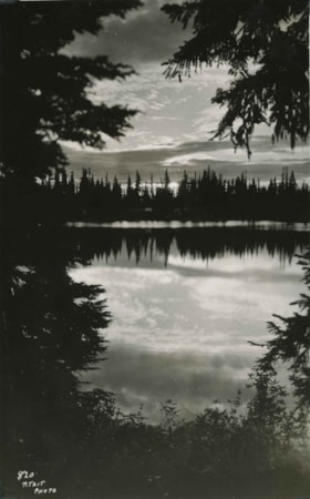
Reflections at Croteau
https://search.heritageburnaby.ca/link/archivedescription51454
- Repository
- City of Burnaby Archives
- Date
- 1938
- Collection/Fonds
- Burnaby Historical Society fonds
- Description Level
- Item
- Physical Description
- 1 photograph : b&w postcard ; 13 x 8 cm, mounted on heavy-weight paper 17.5 x 26.5 cm
- Scope and Content
- Photographic postcard of Croteau lake at dusk. A site along the way. This was part of a trip to the Forbidden Plateau on Vancouver Island made by a small party of City of Courtenay officials. George A. Grant was one of the climbers in the party.
- Repository
- City of Burnaby Archives
- Date
- 1938
- Collection/Fonds
- Burnaby Historical Society fonds
- Subseries
- George Grant subseries
- Physical Description
- 1 photograph : b&w postcard ; 13 x 8 cm, mounted on heavy-weight paper 17.5 x 26.5 cm
- Description Level
- Item
- Record No.
- 243-059
- Access Restriction
- No restrictions
- Reproduction Restriction
- No known restrictions
- Accession Number
- BHS1990-06
- Scope and Content
- Photographic postcard of Croteau lake at dusk. A site along the way. This was part of a trip to the Forbidden Plateau on Vancouver Island made by a small party of City of Courtenay officials. George A. Grant was one of the climbers in the party.
- Media Type
- Photograph
- Photographer
- Tait, Preston L.
- Notes
- Title taken from handwritten title on paper mount
- Handwritten note on facing page reads: "True beauty dwells in deep retreats / Whose veil is unremoved / Wordsworth"
- Photographer identifies photograph as no. 820
Images

Request for Construction of a Sewer for Dominon Bridge Company Plant on Boundary Road
https://search.heritageburnaby.ca/link/councilreport64531
- Repository
- City of Burnaby Archives
- Report ID
- 55667
- Meeting Date
- 7-Apr-1930
- Format
- Council - Mayor/Councillor/Staff Report
- Collection/Fonds
- City Council and Office of the City Clerk fonds
- Repository
- City of Burnaby Archives
- Report ID
- 55667
- Meeting Date
- 7-Apr-1930
- Format
- Council - Mayor/Councillor/Staff Report
- Collection/Fonds
- City Council and Office of the City Clerk fonds
Documents
Request for Permission to Plant a Tree in Central Park in Memory of Mrs. L. Telfor
https://search.heritageburnaby.ca/link/councilreport55400
- Repository
- City of Burnaby Archives
- Report ID
- 71511
- Meeting Date
- 27-Mar-1935
- Format
- Council - Mayor/Councillor/Staff Report
- Collection/Fonds
- City Council and Office of the City Clerk fonds
- Repository
- City of Burnaby Archives
- Report ID
- 71511
- Meeting Date
- 27-Mar-1935
- Format
- Council - Mayor/Councillor/Staff Report
- Collection/Fonds
- City Council and Office of the City Clerk fonds
Documents
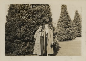
Ruby and Dot
https://search.heritageburnaby.ca/link/museumdescription19432
- Repository
- Burnaby Village Museum
- Date
- 11 Oct. 1936
- Collection/Fonds
- Hawkshaw family fonds
- Description Level
- Item
- Physical Description
- 1 photograph : sepia ; 6.5 x 9 cm
- Scope and Content
- Photograph of two women idenified as Ruby and Dot standing outside in front of large cedar bushes.
- Repository
- Burnaby Village Museum
- Collection/Fonds
- Hawkshaw family fonds
- Description Level
- Item
- Physical Description
- 1 photograph : sepia ; 6.5 x 9 cm
- Scope and Content
- Photograph of two women idenified as Ruby and Dot standing outside in front of large cedar bushes.
- Accession Code
- BV996.6.116
- Access Restriction
- No restrictions
- Reproduction Restriction
- No known restrictions
- Date
- 11 Oct. 1936
- Media Type
- Photograph
- Scan Resolution
- 600
- Scan Date
- 2023-02-06
- Notes
- Title based on contents of photograph
- Caption beneath photograph reads: "Ruby & Dot"
- Caption of album page reads: "Oct 11/36 / THANKSGIVING / SEATTLE"
- Photograph is part of photograph album BV996.6.1
Images


Shell Oil Company
https://search.heritageburnaby.ca/link/landmark675
- Repository
- Burnaby Heritage Planning
- Geographic Access
- Kensington Avenue
- Associated Dates
- ca. 1930-1993
- Heritage Value
- After considering several sites in the Greater Vancouver area, the Shell Oil Company chose 70 acres in North Burnaby with frontage of one third of a mile on Burrard Inlet. Shell proposed to build a four-million dollar plant that would employ up to 2000 - providing some relief in the middle of Burnaby's economic crisis of the Depression years. The site became known as the Shellburn Refinery and was in operation until 1993.
- Historic Neighbourhood
- Lochdale (Historic Neighbourhood)
- Planning Study Area
- Westridge Area
Images

Small family fonds
https://search.heritageburnaby.ca/link/archivedescription91819
- Repository
- City of Burnaby Archives
- Date
- 1922-2016
- Collection/Fonds
- Small family fonds
- Description Level
- Fonds
- Physical Description
- 75 photographs : b&w & col. + 1 plan
- Scope and Content
- Fonds consists of photographs documenting the transformation of the Burnaby Lake area of Burnaby, B.C. from semi-rural in the 1920s to urbanized in 2016. Photographs depict the land and houses located on the corner of Douglas Road and Dominion Street as the property was rezoned and its density quad…
- Repository
- City of Burnaby Archives
- Date
- 1922-2016
- Collection/Fonds
- Small family fonds
- Physical Description
- 75 photographs : b&w & col. + 1 plan
- Description Level
- Fonds
- Access Restriction
- Open access
- Reproduction Restriction
- May be restricted by third party rights
- Accession Number
- 2017-01
- Scope and Content
- Fonds consists of photographs documenting the transformation of the Burnaby Lake area of Burnaby, B.C. from semi-rural in the 1920s to urbanized in 2016. Photographs depict the land and houses located on the corner of Douglas Road and Dominion Street as the property was rezoned and its density quadrupled. Fonds also includes photographs of the Small family house being moved to 5496 Dominion Street and the original landscape plan for 5118 Douglas Road.
- History
- In 1915, John W. Roberts and his wife Mary Allen Roberts moved from the United States to Canada along with their daughter, Lauretta. On first moving to Canada, the family lived in a rented house in Vancouver and John worked as a movie projectionist in the city. The couple had three more children, all sons: John A., Edward, and Roland. Circa 1921, John purchased a large parcel of land at the corner of Douglas Road and Dominion Street in Burnaby. This parcel encompassed the equivalent of at least six 66-foot lots along the south side of Dominion Street and the same along the north side of Norfolk Street. On their property, a barn and small living quarters were built. The family moved in, raising goats and growing potatoes to supplement their income. They also planted cherry, apple, and pear trees; hazelnut and walnut trees; raspberries; and a large vegetable garden, the fruits of which Mary preserved for year-round use. At this time, agricultural activities were common for families in the area: the Roberts' neighbours kept chickens for personal use and for selling eggs; grew mushrooms for commercial sale; and sold manure from an old buckboard drawn by Clydesdale horses. John built a new house in the middle of the Roberts’ lots on the southwest corner of Douglas Road and Dominion Street. The house faced Douglas Road and overlooked a large, well-landscaped front yard to the east and a full-sized, clay tennis court to the north. The family moved into this new house in 1925. When the Roberts ceased raising goats, the barn and original living quarters were reduced to a double-car garage with storage space plus a sawdust-insulated “root cellar”. John also built a house on the northwest corner of the lot at Douglas Road and Dominion Street (3093 Douglas Road), which was purchased by the Hardy family. In 1957, part of this property (3071 Douglas Road) was sold to the Brocklebanks who built a house and lived there. In addition, John built a house at the northwest corner of Douglas Road and Norfolk Street (5106 Douglas Road). The original purchaser of this house is unknown, but in 1949, it was bought by the Meyers family. In 1952 or 1953, the Meyers sold part of this property and the Manahans built a house on it, facing Douglas Road. Several other lots that John owned were also sold off over the years. By the 1950s, John owned only five 66-foot lots from Douglas Road west, along the south side Dominion Street. In 1954, John sold the lot furthest from Douglas Road (5486 Dominion Street) to a builder who built a “ranch-style” house and put it up for sale. John retired from his career as a movie projectionist in the 1950s. He, Mary, and Lauretta retained their US citizenship all their lives, although they never returned to the USA except for brief visits. John A., Edward, and Roland who, as children of US citizens, also had US citizenship, eventually moved to the US, where they remained for the rest of their lives. In 1945, Lauretta married Frederick Small. The couple lived in a rented house in Vancouver for a few years before moving in with John and Mary in Burnaby. The couple had four children: Elizabeth, Kathryn, Charles, and Martin. In 1955, Frederick purchased the rancher at 5486 Dominion Street and the family moved in. The Small children grew up enjoying the freedom of having their grandparent’s large property in addition to their parent’s yard to play in. The back lane that ran between Dominion Street and Norfolk Street was filled with trees and bushes, creating a narrow bit of “forest” to explore. In 1957, John died. Mary died in 1969, as did Frederick. Lauretta was executor for her mother’s and husband’s estates. After much consideration, she decided to sell the house at 5486 Dominion Street and move back into her childhood home. By doing so, she was able to settle her mother’s estate to the satisfaction of her brothers. Elizabeth married and moved away. Over the next few years, the “Roberts” house was home to Lauretta, Kathryn, Charles, and Martin, with the three grown children moving in and out several times during the 1970s. In 1981, Lauretta died. Her children discussed at length how to divide up the property, which consisted of four 66-foot lots, according to her will. None of her children wanted to see the old family house destroyed but the house straddled two lots. They finally decided that if one of them wanted to pay to move the house to sit on one of the lots, the “value” of the house would not enter into the settlement of the estate. Kathryn chose to do this. In 1982, the old house was moved to 5496 Dominion Street and Kathryn continued to live in it. Martin died in 1982. Elizabeth and Charles each inherited one lot and the last lot, which would have gone to Martin, was sold, the funds divided equally between Elizabeth, Kathryn, and Charles. The three lots between 5496 Dominion Street and Douglas Road were subdivided into 33-foot lots and six new houses were built. In 1993, the Meyers property and the Manahan property were subdivided into 33-foot lots facing Norfolk Street and the old houses were torn down and four new houses were built.
- Media Type
- Photograph
- Technical Drawing
- Creator
- Small family
![Snowy backyard, [193-?] (date of original), copied 1992 thumbnail](/media/hpo/_Data/_Archives_Images/_Unrestricted/315/315-098.jpg?width=280)
Snowy backyard
https://search.heritageburnaby.ca/link/archivedescription36743
- Repository
- City of Burnaby Archives
- Date
- [193-?] (date of original), copied 1992
- Collection/Fonds
- Burnaby Historical Society fonds
- Description Level
- Item
- Physical Description
- 1 photograph : b&w ; 8.7 x 12.6 cm print
- Scope and Content
- Photograph of a yard and trees covered with snow. Houses are visible in the background.
- Repository
- City of Burnaby Archives
- Date
- [193-?] (date of original), copied 1992
- Collection/Fonds
- Burnaby Historical Society fonds
- Subseries
- Burnaby Centennial Anthology subseries
- Physical Description
- 1 photograph : b&w ; 8.7 x 12.6 cm print
- Description Level
- Item
- Record No.
- 315-098
- Access Restriction
- No restrictions
- Reproduction Restriction
- No known restrictions
- Accession Number
- BHS1994-04
- Scope and Content
- Photograph of a yard and trees covered with snow. Houses are visible in the background.
- Subjects
- Natural Phenomena - Snow
- Plants - Trees
- Media Type
- Photograph
- Notes
- Title based on contents of photograph
Images
![Snowy backyard, [193-?] (date of original), copied 1992 thumbnail](/media/hpo/_Data/_Archives_Images/_Unrestricted/315/315-098.jpg)