Narrow Results By
Subject
- Aerial Photographs 1
- Agriculture - Farms 1
- Animals - Dogs 1
- Armament - Munitions 1
- Buildings - Commercial - Grocery Stores 2
- Buildings - Commercial - Train Stations 1
- Buildings - Heritage 1
- Buildings - Industrial 1
- Buildings - Industrial - Factories 1
- Buildings - Residential - Houses 1
- Celebrations 1
- Clothing - Military Uniforms 1
Creator
- Bingham, Alfred "Alf" 4
- Brainerd family 1
- British Columbia Electric Company 2
- City of Burnaby 1
- Eagles, Dr. Blythe 1
- Eagles, Dr. Violet 1
- Ehlers, Edith "Edie" Fleming 1
- Ettinger, James Gilmore 1
- Fleming, Frances "Fanny" Waplington 1
- Green, George, 1872-1955 1
- Lee, Chue Kan "Cecil" 1
- Lee, Julie Cho Chan 1
Shell and Standard Oil Plants - Odor Complaints
https://search.heritageburnaby.ca/link/councilreport48585
- Repository
- City of Burnaby Archives
- Report ID
- 48425
- Meeting Date
- 9-Aug-1948
- Format
- Council - Mayor/Councillor/Staff Report
- Collection/Fonds
- City Council and Office of the City Clerk fonds
- Repository
- City of Burnaby Archives
- Report ID
- 48425
- Meeting Date
- 9-Aug-1948
- Format
- Council - Mayor/Councillor/Staff Report
- Collection/Fonds
- City Council and Office of the City Clerk fonds
Documents

McColl-Frontenac Oil Company
https://search.heritageburnaby.ca/link/landmark682
- Repository
- Burnaby Heritage Planning
- Associated Dates
- 1945
- Heritage Value
- In 1945, the McColl-Frontenac Oil Company purchased the western section of what used to be the Barnet Mill site from the City of Burnaby. McColl-Frontenac handled the distribution of Texaco gas and built a new plant at the site for this purpose. The company built an improved road access to the plant which later became known as Texaco Drive. Competition from other refineries eventually forced the closure of this plant and in 1985 the area was acquired by the Municipality for the expansion of Barnet Marine Park.
- Historic Neighbourhood
- Barnet (Historic Neighbourhood)
- Planning Study Area
- Burnaby Mountain Area
Images


Shell Oil Company
https://search.heritageburnaby.ca/link/landmark675
- Repository
- Burnaby Heritage Planning
- Geographic Access
- Kensington Avenue
- Associated Dates
- ca. 1930-1993
- Heritage Value
- After considering several sites in the Greater Vancouver area, the Shell Oil Company chose 70 acres in North Burnaby with frontage of one third of a mile on Burrard Inlet. Shell proposed to build a four-million dollar plant that would employ up to 2000 - providing some relief in the middle of Burnaby's economic crisis of the Depression years. The site became known as the Shellburn Refinery and was in operation until 1993.
- Historic Neighbourhood
- Lochdale (Historic Neighbourhood)
- Planning Study Area
- Westridge Area
Images


Broadview Neighbourhood
https://search.heritageburnaby.ca/link/landmark687
- Repository
- Burnaby Heritage Planning
- Associated Dates
- 1925-1954
- Heritage Value
- Development in the Broadview area slowed during World War Two, but after the war, the area became home to a number of industrial sites. The first major plant to be built here was the Dominion Bridge Company which opened in 1930.
- Historic Neighbourhood
- Broadview (Historic Neighbourhood)
- Planning Study Area
- Cascade-Schou Area
Images


Kelly-Douglas Company
https://search.heritageburnaby.ca/link/landmark697
- Repository
- Burnaby Heritage Planning
- Geographic Access
- Kingsway
- Associated Dates
- 1946
- Heritage Value
- The Kelly Douglas Company was founded in 1896 as a wholesale grocery business. It enjoyed rapid success during the Klondike Goldrush of 1898 when it became a primary supplier for prospectors. In 1946, its headquarters moved from Vancouver to Burnaby and a manufacturing plant and warehouse was built on the site.
- Historic Neighbourhood
- Central Park (Historic Neighbourhood)
- Planning Study Area
- Maywood Area
- Street Address
- 4700 Kingsway
Images


Rosalie (Moore) Barrett Residence
https://search.heritageburnaby.ca/link/landmark498
- Repository
- Burnaby Heritage Planning
- Description
- The Rosalie (Moore) Barrett Residence is a one-storey ranch-style bungalow with a cross-gabled roofline, located on Sperling Avenue. It is located within the Deer Lake Park Heritage Precinct, and is adjacent to a related house, the Ethel Moore Residence, built the previous year.
- Associated Dates
- 1942
- Street View URL
- Google Maps Street View
- Repository
- Burnaby Heritage Planning
- Geographic Access
- Sperling Avenue
- Associated Dates
- 1942
- Description
- The Rosalie (Moore) Barrett Residence is a one-storey ranch-style bungalow with a cross-gabled roofline, located on Sperling Avenue. It is located within the Deer Lake Park Heritage Precinct, and is adjacent to a related house, the Ethel Moore Residence, built the previous year.
- Heritage Value
- This house is significant for its connection with first owner, Rosalie Barrett, the daughter of Ethel Hutchings Moore, who lived in the adjacent house at 5145 Sperling Avenue. A spacious modernist bungalow, it was constructed in 1942, and was designed by Rosalie Moore herself. Moore intended to build several houses on this property, but further development was curtailed due to wartime restrictions on domestic construction. The Rosalie (Moore) Barrett Residence is a testament to Deer Lake's continued popularity as a residential neighbourhood in the 1940s. Although Burnaby was serviced by a number of transportation links at the time, the increasing availability of automobiles provided improved access to outlying suburbs. Rising real estate prices in Vancouver and New Westminster attracted residents to this neighbourhood because of its relative affordability, central location and beautiful scenery.
- Defining Elements
- Key elements that define the heritage character of the Rosalie (Moore) Barrett Residence include its: - location within the Deer Lake Park Heritage Precinct - residential form, scale and massing as expressed by its one-storey height, rambling linear plan and cross-gabled roof - wood-frame construction with stucco siding and waney-edged boards in the gable peaks - red brick on the front façade and rough-cut granite at the base of the house - Modernist design as exemplified by the asymmetrical, linear plan with low pitched roof - internal granite chimney - original windows, including wooden-sash casement windows in double and triple-assembly with four-part, horizontal leading - original front door with glass block sidelights - associated landscape features such as granite gateposts, foundation plantings and mature coniferous trees
- Historic Neighbourhood
- Burnaby Lake (Historic Neighbourhood)
- Planning Study Area
- Morley-Buckingham Area
- Function
- Primary Historic--Single Dwelling
- Primary Current--Single Dwelling
- Community
- Deer Lake
- Cadastral Identifier
- P.I.D.006-082-696
- Boundaries
- The Rosalie (Moore) Barrett Residence is comprised of a single residential lot located at 5155 Sperling Avenue, Burnaby.
- Area
- 11291.44
- Contributing Resource
- Building
- Ownership
- Public (local)
- Documentation
- City of Burnaby Planning and Building Department, Heritage Site Files
- Street Address
- 5155 Sperling Avenue
- Street View URL
- Google Maps Street View
Images


Copies of photographs from Esther (Love) Stanley albums
https://search.heritageburnaby.ca/link/museumdescription10003
- Repository
- Burnaby Village Museum
- Date
- [1915-1950] (date of originals), copied 1989
- Collection/Fonds
- Burnaby Village Museum fonds
- Description Level
- File
- Physical Description
- 36 photographs : b&w negatives ; 35 mm
- Scope and Content
- Photographs copied from various photograph albums including; Albert Paker, George Love, Gordon Love and Esther (Love) Stanley. Content includes: Love family in front of the piano inside parlour; Love family members with musical instruments inside parlour; Ben Brandrith and Robert Love in uniforms; …
- Repository
- Burnaby Village Museum
- Collection/Fonds
- Burnaby Village Museum fonds
- Series
- Jesse Love farmhouse series
- Subseries
- Love family photographs subseries
- Description Level
- File
- Physical Description
- 36 photographs : b&w negatives ; 35 mm
- Scope and Content
- Photographs copied from various photograph albums including; Albert Paker, George Love, Gordon Love and Esther (Love) Stanley. Content includes: Love family in front of the piano inside parlour; Love family members with musical instruments inside parlour; Ben Brandrith and Robert Love in uniforms; unidentified Asian man in field with hoe and young trees behind him; wedding cake from Frank Charles Stanley and Esther Love's wedding; land clearing for Love farmhouse; Jesse Love feeding chickens; Jesse and Hannah (Girlie) Love in hats outside on Love farm; large picnic on grass; four generations of Love family members; gatherings of Love family members outside; Love family posed in a car inside a studio (Will, Sarah, George, Phoebe and Martha); Leonard Love dressed as a boy scout; Martha (Dot) with children; Love family members celebrate centennial; Jesse Love and Martha (Dot) Love outside Love farmhouse; Love farmhouse with porch and garden; swing at Love farmhouse; Parker family in living room and view of the Love farmhouse from the front.
- Geographic Access
- Cumberland Street
- Street Address
- 7651 Cumberland Street
- Accession Code
- BV018.41.184
- Access Restriction
- No restrictions
- Reproduction Restriction
- May be restricted by third party rights
- Date
- [1915-1950] (date of originals), copied 1989
- Media Type
- Photograph
- Historic Neighbourhood
- East Burnaby (Historic Neighbourhood)
- Planning Study Area
- Cariboo-Armstrong Area
- Scan Date
- 4-Mar-2019
- Notes
- Title based on contents of photograph
- 36 b&w copy prints accompanying
Progress report
https://search.heritageburnaby.ca/link/museumlibrary7355
- Repository
- Burnaby Village Museum
- Collection
- Reference Collection
- Material Type
- Moving Images
- Call Number
- 388.46 BCH VR
- Contributor
- British Columbia Electric Company
- Place of Publication
- [British Columbia, Canada]
- Publisher
- BC Hydro
- Publication Date
- c1947
- Physical Description
- 1 videodisc (13 min.) : sd., b&w. ; 4 3/4 in.
- Library Subject (LOC)
- Natural gas industry
- Local transit
- Hydroelectric power plants
- Electric railroads
- Electric power-plants
- Transportation
- British Columbia--History
- Subjects
- Transportation
- Geographic Access
- Vancouver
- Notes
- Summary: Promotional film. The BC Electric Railway Company's $50 million post-war expansion and modernization program, to be completed by 1950. Includes: expansion of transit services, including start of the switch from streetcars to trolley buses; water gas plant; explanation of the Bridge River project, with footage of construction (including La Joie Falls storage dam); Lower Mainland power sub-stations. Various Vancouver street scenes, especially Fraser Street and downtown
- Credit note : sponsored/presented by: British Columbia Electric Company; producer: Lew M. Parry; producing agency/company: Trans-Canada Films Ltd.
Lillian Carman
https://search.heritageburnaby.ca/link/archivedescription77810
- Repository
- City of Burnaby Archives
- Date
- 1944
- Collection/Fonds
- Yanko family fonds
- Description Level
- Item
- Physical Description
- 1 photograph : b&w ; 8 x 5.5 cm
- Scope and Content
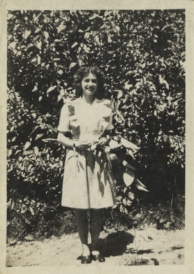
- Photograph of Leida Doria "Lillian Doris" Carman (later Yanko) standing near an apple tree in Nelson, British Columbia.
- Repository
- City of Burnaby Archives
- Date
- 1944
- Collection/Fonds
- Yanko family fonds
- Physical Description
- 1 photograph : b&w ; 8 x 5.5 cm
- Material Details
- Secured to album page with photo corners
- Description Level
- Item
- Record No.
- 545-045
- Access Restriction
- No restrictions
- Reproduction Restriction
- No known restrictions
- Accession Number
- 2012-09
- Scope and Content
- Photograph of Leida Doria "Lillian Doris" Carman (later Yanko) standing near an apple tree in Nelson, British Columbia.
- Subjects
- Plants - Trees
- Media Type
- Photograph
- Notes
- Title based on contents of photograph
- Note in pencil on verso of photograph reads: "Lillian Carman Yanko / apple tree / Nelson"
- Note written on album page reads: "1944 / Lillian - Apple Tree - Nelson, BC"
- Note in blue ink on verso of photograph reads: "1944"
Images

Jenny Nagy
https://search.heritageburnaby.ca/link/archivedescription77858
- Repository
- City of Burnaby Archives
- Date
- June 1946
- Collection/Fonds
- Yanko family fonds
- Description Level
- Item
- Physical Description
- 1 photograph : b&w ; 6 x 10.5 cm
- Scope and Content
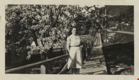
- Photograph of Eugenia “Jenny” (Haresomovych) (Carman) Nagy standing on a planked sidewalk under blossoming fruit trees. This photograph was taken in Nelson, British Columbia.
- Repository
- City of Burnaby Archives
- Date
- June 1946
- Collection/Fonds
- Yanko family fonds
- Physical Description
- 1 photograph : b&w ; 6 x 10.5 cm
- Material Details
- Secured to album page with photo corners
- Description Level
- Item
- Record No.
- 545-074
- Access Restriction
- No restrictions
- Reproduction Restriction
- No known restrictions
- Accession Number
- 2012-09
- Scope and Content
- Photograph of Eugenia “Jenny” (Haresomovych) (Carman) Nagy standing on a planked sidewalk under blossoming fruit trees. This photograph was taken in Nelson, British Columbia.
- Subjects
- Plants - Trees
- Media Type
- Photograph
- Notes
- Title based on contents of photograph
- Note in black ink on verso of photograph reads: "Mum / June 1946"
Images

Newlyweds Lillian and John Yanko
https://search.heritageburnaby.ca/link/archivedescription79339
- Repository
- City of Burnaby Archives
- Date
- May 15, 1949
- Collection/Fonds
- Yanko family fonds
- Description Level
- Item
- Physical Description
- 1 photograph : b&w ; 7.5 x 5.5 cm
- Scope and Content
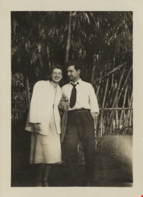
- Photograph of newlyweds Leida Doria "Lillian Doris" (Carman) Yanko and John Ivan Yanko standing arm in arm in front of a forest of bamboo in Vancouver, British Columbia.
- Repository
- City of Burnaby Archives
- Date
- May 15, 1949
- Collection/Fonds
- Yanko family fonds
- Physical Description
- 1 photograph : b&w ; 7.5 x 5.5 cm
- Material Details
- Secured to album page with photo corners
- Description Level
- Item
- Record No.
- 545-150
- Access Restriction
- No restrictions
- Reproduction Restriction
- No restrictions
- Accession Number
- 2012-09
- Scope and Content
- Photograph of newlyweds Leida Doria "Lillian Doris" (Carman) Yanko and John Ivan Yanko standing arm in arm in front of a forest of bamboo in Vancouver, British Columbia.
- Subjects
- Plants
- Media Type
- Photograph
- Notes
- Title based on contents of photograph
- Note written on album page reads: "15 May 1948 / 'By the Bamboo'"
- Note in black ink on verso of photograph reads: "May 15, 1949 / By the Bamboo, Trees, Vanc. B.C."
- 1 duplicate photograph accompanying
Images

![Two large walnut trees, [194-] (date of original), copied 2014 thumbnail](/media/hpo/_Data/_Archives_Images/_Unrestricted/580/581-010.jpg?width=280)
Two large walnut trees
https://search.heritageburnaby.ca/link/archivedescription88404
- Repository
- City of Burnaby Archives
- Date
- [194-] (date of original), copied 2014
- Collection/Fonds
- James Massey family fonds
- Description Level
- Item
- Physical Description
- 1 photograph (tiff) : sepia ; 600 dpi
- Scope and Content
- Photograph of two large walnut trees on either side of a trail in Robert Burnaby Park.
- Repository
- City of Burnaby Archives
- Date
- [194-] (date of original), copied 2014
- Collection/Fonds
- James Massey family fonds
- Physical Description
- 1 photograph (tiff) : sepia ; 600 dpi
- Description Level
- Item
- Record No.
- 581-010
- Access Restriction
- No restrictions
- Reproduction Restriction
- No reproduction permitted
- Accession Number
- 2014-34
- Scope and Content
- Photograph of two large walnut trees on either side of a trail in Robert Burnaby Park.
- Media Type
- Photograph
- Notes
- Title based on contents of photograph
- Historic Neighbourhood
- East Burnaby (Historic Neighbourhood)
- Planning Study Area
- Lakeview-Mayfield Area
Images
![Two large walnut trees, [194-] (date of original), copied 2014 thumbnail](/media/hpo/_Data/_Archives_Images/_Unrestricted/580/581-010.jpg)
![Garden in Robert Burnaby Park, [between 1949 and 1959] (date of original), copied 2014 thumbnail](/media/hpo/_Data/_Archives_Images/_Unrestricted/580/581-011.jpg?width=280)
Garden in Robert Burnaby Park
https://search.heritageburnaby.ca/link/archivedescription88405
- Repository
- City of Burnaby Archives
- Date
- [between 1949 and 1959] (date of original), copied 2014
- Collection/Fonds
- James Massey family fonds
- Description Level
- Item
- Physical Description
- 1 photograph (tiff) : sepia ; 600 dpi
- Scope and Content
- Photograph of the garden and fence in Robert Burnaby Park. Alice Massey is standing in the centre of the photograph near a large bunch of poppies with an unidentified woman to the left.
- Repository
- City of Burnaby Archives
- Date
- [between 1949 and 1959] (date of original), copied 2014
- Collection/Fonds
- James Massey family fonds
- Physical Description
- 1 photograph (tiff) : sepia ; 600 dpi
- Description Level
- Item
- Record No.
- 581-011
- Access Restriction
- No restrictions
- Reproduction Restriction
- May be restricted by third party rights
- Accession Number
- 2014-34
- Scope and Content
- Photograph of the garden and fence in Robert Burnaby Park. Alice Massey is standing in the centre of the photograph near a large bunch of poppies with an unidentified woman to the left.
- Media Type
- Photograph
- Notes
- Title based on contents of photograph
- Historic Neighbourhood
- East Burnaby (Historic Neighbourhood)
- Planning Study Area
- Lakeview-Mayfield Area
Images
![Garden in Robert Burnaby Park, [between 1949 and 1959] (date of original), copied 2014 thumbnail](/media/hpo/_Data/_Archives_Images/_Unrestricted/580/581-011.jpg)

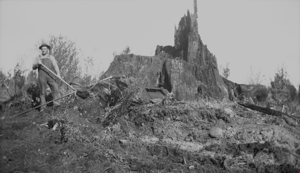
Alfred Bingham
https://search.heritageburnaby.ca/link/archivedescription34149
- Repository
- City of Burnaby Archives
- Date
- April 20, 1947
- Collection/Fonds
- Burnaby Historical Society fonds
- Description Level
- Item
- Physical Description
- 1 photograph : b&w negative ; 11.3 x 6.8 cm
- Scope and Content
- Photograph of Alfred "Alf" Bingham standing in front of a fir tree stump that is approximately 400 years old on the 4200 block of Kitchener Street. This is part of the Willingdon Heights subdivision site.
- Repository
- City of Burnaby Archives
- Date
- April 20, 1947
- Collection/Fonds
- Burnaby Historical Society fonds
- Subseries
- Alfred Bingham subseries
- Physical Description
- 1 photograph : b&w negative ; 11.3 x 6.8 cm
- Description Level
- Item
- Record No.
- 010-066
- Access Restriction
- No restrictions
- Reproduction Restriction
- Reproduce for fair dealing purposes only
- Accession Number
- BHS2007-04
- Scope and Content
- Photograph of Alfred "Alf" Bingham standing in front of a fir tree stump that is approximately 400 years old on the 4200 block of Kitchener Street. This is part of the Willingdon Heights subdivision site.
- Subjects
- Land Clearing
- Plants - Trees
- Names
- Bingham, Alfred "Alf"
- Media Type
- Photograph
- Photographer
- Bingham, Alfred "Alf"
- Notes
- Title based on contents of photograph
- Geographic Access
- Kitchener Street
Images


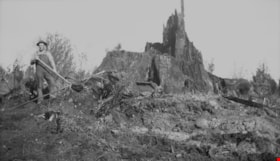
Grant Street
https://search.heritageburnaby.ca/link/archivedescription34157
- Repository
- City of Burnaby Archives
- Date
- April 25, 1947
- Collection/Fonds
- Burnaby Historical Society fonds
- Description Level
- Item
- Physical Description
- 1 photograph : b&w negative ; 6.8 x 10.9 cm
- Scope and Content
- Photograph of a fir stump with 670 rings on the 4200 block of Grant Street. An unidentified man is standing to the left of it with a shovel. This is part of the Willingdon Heights subdivision site.
- Repository
- City of Burnaby Archives
- Date
- April 25, 1947
- Collection/Fonds
- Burnaby Historical Society fonds
- Subseries
- Alfred Bingham subseries
- Physical Description
- 1 photograph : b&w negative ; 6.8 x 10.9 cm
- Description Level
- Item
- Record No.
- 010-074
- Access Restriction
- No restrictions
- Reproduction Restriction
- Reproduce for fair dealing purposes only
- Accession Number
- BHS2007-04
- Scope and Content
- Photograph of a fir stump with 670 rings on the 4200 block of Grant Street. An unidentified man is standing to the left of it with a shovel. This is part of the Willingdon Heights subdivision site.
- Subjects
- Land Clearing
- Plants - Trees
- Media Type
- Photograph
- Photographer
- Bingham, Alfred "Alf"
- Notes
- Title based on contents of photograph
- Geographic Access
- Grant Street
Images

Ready to blast
https://search.heritageburnaby.ca/link/archivedescription34158
- Repository
- City of Burnaby Archives
- Date
- April 25, 1947
- Collection/Fonds
- Burnaby Historical Society fonds
- Description Level
- Item
- Physical Description
- 1 photograph : b&w negative ; 6.8 x 11.3 cm
- Scope and Content
- Photograph(s) restricted for commercial use under FOIPPA. Review for the amount of personal information depicted in the photograph(s) in relation to the researcher's intended use.
- Repository
- City of Burnaby Archives
- Date
- April 25, 1947
- Collection/Fonds
- Burnaby Historical Society fonds
- Subseries
- Alfred Bingham subseries
- Physical Description
- 1 photograph : b&w negative ; 6.8 x 11.3 cm
- Description Level
- Item
- Record No.
- 010-075
- Access Restriction
- No restrictions
- Reproduction Restriction
- Reproduce for fair dealing purposes only
- Accession Number
- BHS2007-04
- Scope and Content
- Photograph(s) restricted for commercial use under FOIPPA. Review for the amount of personal information depicted in the photograph(s) in relation to the researcher's intended use.
- Permission of the estate of Alfred "Alf" Bingham required to reproduce for purposes other than fair dealing. Copyright expires in 2050. Contact information (if available) located in accession record.
- Media Type
- Photograph
- Photographer
- Bingham, Alfred "Alf"
- Notes
- Title based on contents of photograph
Images

Fir stump
https://search.heritageburnaby.ca/link/archivedescription34165
- Repository
- City of Burnaby Archives
- Date
- May 1, 1947
- Collection/Fonds
- Burnaby Historical Society fonds
- Description Level
- Item
- Physical Description
- 1 photograph : b&w negative ; 6.8 x 11.4 cm
- Scope and Content
- Photograph of fir tree stump taken after blasting on the 4200 block of Grant Street. This is part of the Willingdon Heights subdivision site.
- Repository
- City of Burnaby Archives
- Date
- May 1, 1947
- Collection/Fonds
- Burnaby Historical Society fonds
- Subseries
- Alfred Bingham subseries
- Physical Description
- 1 photograph : b&w negative ; 6.8 x 11.4 cm
- Description Level
- Item
- Record No.
- 010-082
- Access Restriction
- No restrictions
- Reproduction Restriction
- No known restrictions
- Accession Number
- BHS2007-04
- Scope and Content
- Photograph of fir tree stump taken after blasting on the 4200 block of Grant Street. This is part of the Willingdon Heights subdivision site.
- Subjects
- Land Clearing
- Plants - Trees
- Media Type
- Photograph
- Photographer
- Bingham, Alfred "Alf"
- Notes
- Title based on contents of photograph
- Geographic Access
- Grant Street
Images


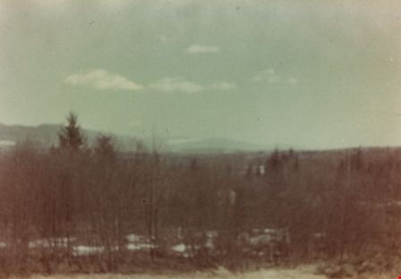
Taken from Armstrong Avenue School
https://search.heritageburnaby.ca/link/archivedescription35044
- Repository
- City of Burnaby Archives
- Date
- 1949 (date of original), copied 1986
- Collection/Fonds
- Burnaby Historical Society fonds
- Description Level
- Item
- Physical Description
- 1 photograph : col. ; 8.8 x 12.5 cm print
- Scope and Content
- Photograph taken from an Armstrong Avenue School classroom. An annotation on the back of the photograph reads, "View from the second floor of Armstrong Ave School looking North to Burnaby Lake, 1949."
- Repository
- City of Burnaby Archives
- Date
- 1949 (date of original), copied 1986
- Collection/Fonds
- Burnaby Historical Society fonds
- Subseries
- Chamberlain family subseries
- Physical Description
- 1 photograph : col. ; 8.8 x 12.5 cm print
- Description Level
- Item
- Record No.
- 179-015
- Access Restriction
- No restrictions
- Reproduction Restriction
- Reproduce for fair dealing purposes only
- Accession Number
- BHS1986-27
- Scope and Content
- Photograph taken from an Armstrong Avenue School classroom. An annotation on the back of the photograph reads, "View from the second floor of Armstrong Ave School looking North to Burnaby Lake, 1949."
- Subjects
- Plants - Trees
- Names
- Armstrong Avenue School
- Media Type
- Photograph
- Notes
- Title based on contents of photograph
- Print made from col. slide
- Geographic Access
- Armstrong Avenue
- Street Address
- 8757 Armstrong Avenue
- Historic Neighbourhood
- East Burnaby (Historic Neighbourhood)
- Planning Study Area
- Cariboo-Armstrong Area
Images

The Moody Tree
https://search.heritageburnaby.ca/link/archivedescription36085
- Repository
- City of Burnaby Archives
- Date
- 1948
- Collection/Fonds
- Burnaby Historical Society fonds
- Description Level
- Item
- Physical Description
- 1 photograph : b&w ; 17 x 12.5 cm
- Scope and Content
- Photograph of the Moody Tree, a European Ash, which was presented by Colonel Moody to Mr. and Mrs. William Holmes and planted by Mrs. Holmes in the fall of 1861. The home of Mr & Mrs W. Holmes is visible in the background. This tree is on Lot 1, beside the Brunette, at the eastern side of Colby Str…
- Repository
- City of Burnaby Archives
- Date
- 1948
- Collection/Fonds
- Burnaby Historical Society fonds
- Subseries
- Columbian Newspaper subseries
- Physical Description
- 1 photograph : b&w ; 17 x 12.5 cm
- Description Level
- Item
- Record No.
- 222-008
- Access Restriction
- No restrictions
- Reproduction Restriction
- No known restrictions
- Accession Number
- BHS1989-19
- Scope and Content
- Photograph of the Moody Tree, a European Ash, which was presented by Colonel Moody to Mr. and Mrs. William Holmes and planted by Mrs. Holmes in the fall of 1861. The home of Mr & Mrs W. Holmes is visible in the background. This tree is on Lot 1, beside the Brunette, at the eastern side of Colby Street and a few feet from the New Westminister border.
- Subjects
- Plants - Trees
- Media Type
- Photograph
- Notes
- Title based on contents of photograph
- Stamp of copyright on verso of photograph
- Glued to the verso is a photocopy of the photograph with information typed below, identifing the tree as "The Moody Tree"
- Geographic Access
- 10th Avenue
- North Road
- Planning Study Area
- Cariboo-Armstrong Area
Images

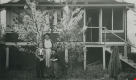
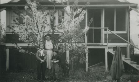
Allen family
https://search.heritageburnaby.ca/link/archivedescription36794
- Repository
- City of Burnaby Archives
- Date
- 1940 (date of original), copied 1992
- Collection/Fonds
- Burnaby Historical Society fonds
- Description Level
- Item
- Physical Description
- 1 photograph : b&w ; 7.4 x 12.3 cm print
- Scope and Content
- Photograph of the Allen family mother and daughters in front of a blossoming tree. Left to right: Pat, Marjorie (mother) and Stephanie. This photograph was taken at their home at 3976 McGill Street.
- Repository
- City of Burnaby Archives
- Date
- 1940 (date of original), copied 1992
- Collection/Fonds
- Burnaby Historical Society fonds
- Subseries
- Burnaby Centennial Anthology subseries
- Physical Description
- 1 photograph : b&w ; 7.4 x 12.3 cm print
- Description Level
- Item
- Record No.
- 315-251
- Access Restriction
- No restrictions
- Reproduction Restriction
- No known restrictions
- Accession Number
- BHS1994-04
- Scope and Content
- Photograph of the Allen family mother and daughters in front of a blossoming tree. Left to right: Pat, Marjorie (mother) and Stephanie. This photograph was taken at their home at 3976 McGill Street.
- Media Type
- Photograph
- Notes
- Title based on contents of photograph
- Geographic Access
- McGill Street
- Street Address
- 3976 McGill Street
- Historic Neighbourhood
- Vancouver Heights (Historic Neighbourhood)
- Planning Study Area
- Burnaby Heights Area
Images