Narrow Results By
Subject
- Agriculture - Fruit and Berries 1
- Animals - Cats 1
- Buildings - Heritage 1
- Buildings - Residential - Houses 1
- Geographic Features - Fields 1
- Geographic Features - Roads 2
- Holidays - Christmas 1
- Land Clearing 3
- Musical Instruments - Pianos 1
- Natural Phenomena - Snow 1
- Officials - Alderman and Councillors 1
- Plants - Flowers 1

Allanson family clearing land
https://search.heritageburnaby.ca/link/archivedescription35793
- Repository
- City of Burnaby Archives
- Date
- 1923 (date of original), copied 1986
- Collection/Fonds
- Burnaby Historical Society fonds
- Description Level
- Item
- Physical Description
- 1 photograph : b&w ; 12.7 x 17.8 cm print
- Scope and Content
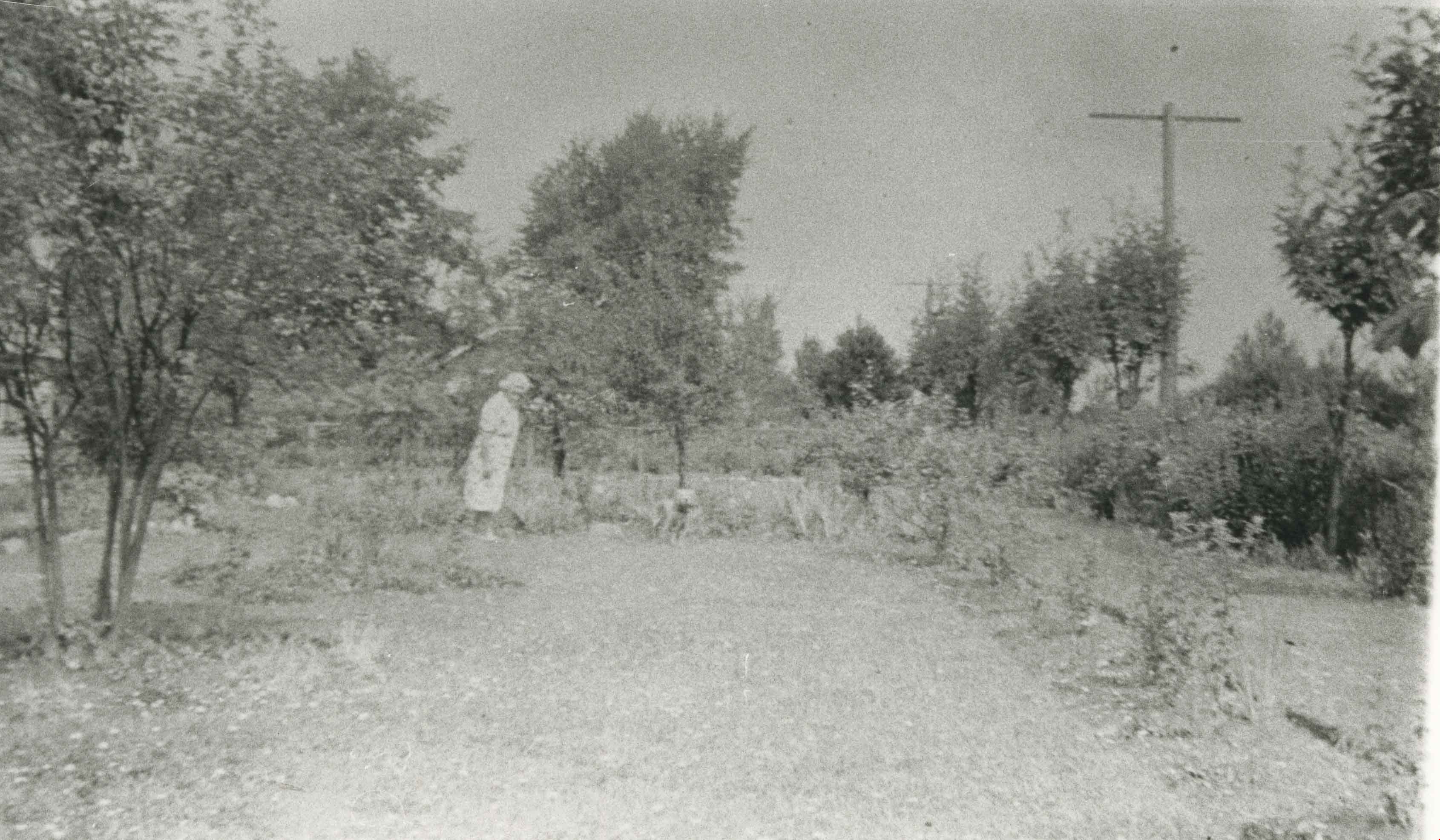
- Photograph of the Allanson family clearing the land at 12 Warwick Avenue bought by Malcolm and Mabel Allanson. Left to right: William Allanson, Mabel Allanson, Malcolm Allanson, and Jessie Allanson. William and Jessie Allanson are the parents of Malcolm. Mabel and Malcolm Allanson are married.
- Repository
- City of Burnaby Archives
- Date
- 1923 (date of original), copied 1986
- Collection/Fonds
- Burnaby Historical Society fonds
- Subseries
- Pioneer Tales subseries
- Physical Description
- 1 photograph : b&w ; 12.7 x 17.8 cm print
- Description Level
- Item
- Record No.
- 204-651
- Access Restriction
- No restrictions
- Reproduction Restriction
- No known restrictions
- Accession Number
- BHS1988-03
- Scope and Content
- Photograph of the Allanson family clearing the land at 12 Warwick Avenue bought by Malcolm and Mabel Allanson. Left to right: William Allanson, Mabel Allanson, Malcolm Allanson, and Jessie Allanson. William and Jessie Allanson are the parents of Malcolm. Mabel and Malcolm Allanson are married.
- Subjects
- Land Clearing
- Plants - Trees
- Media Type
- Photograph
- Notes
- Title based on contents of photograph
- Geographic Access
- Warwick Avenue
- Street Address
- 12 Warwick Avenue
- Historic Neighbourhood
- Capitol Hill (Historic Neighbourhood)
- Planning Study Area
- Capitol Hill Area
Images


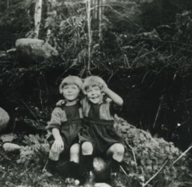
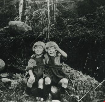
Annie Eshelby in front of a felled tree
https://search.heritageburnaby.ca/link/archivedescription35363
- Repository
- City of Burnaby Archives
- Date
- 1924
- Collection/Fonds
- Burnaby Historical Society fonds
- Description Level
- Item
- Physical Description
- 1 photograph : b&w ; 12.7 x 17.8 cm print
- Scope and Content
- Photograph of Mrs. Annie Eshelby in front of a felled tree measuring six feet in diameter. She is sitting on a chair with a black and white cat lying across her lap. This photograph was taken at the lot on Fell Avenue and Dundas Street, North Burnaby, which was cleared for the Eshelby family home. …
- Repository
- City of Burnaby Archives
- Date
- 1924
- Collection/Fonds
- Burnaby Historical Society fonds
- Subseries
- Pioneer Tales subseries
- Physical Description
- 1 photograph : b&w ; 12.7 x 17.8 cm print
- Description Level
- Item
- Record No.
- 204-220
- Access Restriction
- No restrictions
- Reproduction Restriction
- No known restrictions
- Accession Number
- BHS1988-03
- Scope and Content
- Photograph of Mrs. Annie Eshelby in front of a felled tree measuring six feet in diameter. She is sitting on a chair with a black and white cat lying across her lap. This photograph was taken at the lot on Fell Avenue and Dundas Street, North Burnaby, which was cleared for the Eshelby family home. Annie Eshelby (nee Perrey) was married to Frank Eshelby. They settled in Burnaby after moving from England in 1922.
- Subjects
- Animals - Cats
- Land Clearing
- Plants - Trees
- Names
- Eshelby, Annie Perrey
- Media Type
- Photograph
- Notes
- Title based on contents of photograph
- Geographic Access
- Fell Avenue
- Dundas Street
- Historic Neighbourhood
- Capitol Hill (Historic Neighbourhood)
- Planning Study Area
- Capitol Hill Area
Images

![Blasting stump, [1921 or 1922] (date of original), digitally copied 2012 thumbnail](/media/hpo/_Data/_Archives_Images/_Unrestricted/540/549-008.jpg?width=280)
Blasting stump
https://search.heritageburnaby.ca/link/archivedescription76891
- Repository
- City of Burnaby Archives
- Date
- [1921 or 1922] (date of original), digitally copied 2012
- Collection/Fonds
- Community Heritage Commission Special Projects fonds
- Description Level
- Item
- Physical Description
- 1 photograph (jpeg) : col. ; 300ppi
- Scope and Content
- Photograph of members of the Brown-John family sitting and standing on the blasting stump. This stump was located near the corner of Gilmore Avenue and Napier Street.
- Repository
- City of Burnaby Archives
- Date
- [1921 or 1922] (date of original), digitally copied 2012
- Collection/Fonds
- Community Heritage Commission Special Projects fonds
- Physical Description
- 1 photograph (jpeg) : col. ; 300ppi
- Description Level
- Item
- Record No.
- 549-008
- Access Restriction
- No restrictions
- Reproduction Restriction
- No known restrictions
- Accession Number
- 2012-30
- Scope and Content
- Photograph of members of the Brown-John family sitting and standing on the blasting stump. This stump was located near the corner of Gilmore Avenue and Napier Street.
- Subjects
- Plants - Trees
- Names
- Brown-John, Victor Joseph Charles
- Brown-John, Archie
- Brown-John, Frank
- Brown-John, Roy
- Ansdell, Elsie Brown-John
- Brown-John, Clive
- Media Type
- Photograph
- Notes
- Title based on contents of photograph
- Geographic Access
- Gilmore Avenue
- Napier Street
- Historic Neighbourhood
- Vancouver Heights (Historic Neighbourhood)
- Planning Study Area
- Willingdon Heights Area
Images
![Blasting stump, [1921 or 1922] (date of original), digitally copied 2012 thumbnail](/media/hpo/_Data/_Archives_Images/_Unrestricted/540/549-008.jpg)
![Blasting stump, [1920] (date of original), digitally copied 2012 thumbnail](/media/hpo/_Data/_Archives_Images/_Unrestricted/540/549-009.jpg?width=280)
Blasting stump
https://search.heritageburnaby.ca/link/archivedescription76892
- Repository
- City of Burnaby Archives
- Date
- [1920] (date of original), digitally copied 2012
- Collection/Fonds
- Community Heritage Commission Special Projects fonds
- Description Level
- Item
- Physical Description
- 1 photograph (jpeg) : col. ; 300ppi
- Scope and Content
- Photograph of the Brown-John children playing on the blasting stump that was located near the corner of Gilmore Avenue and Napier Street.
- Repository
- City of Burnaby Archives
- Date
- [1920] (date of original), digitally copied 2012
- Collection/Fonds
- Community Heritage Commission Special Projects fonds
- Physical Description
- 1 photograph (jpeg) : col. ; 300ppi
- Description Level
- Item
- Record No.
- 549-009
- Access Restriction
- No restrictions
- Reproduction Restriction
- No known restrictions
- Accession Number
- 2012-30
- Scope and Content
- Photograph of the Brown-John children playing on the blasting stump that was located near the corner of Gilmore Avenue and Napier Street.
- Subjects
- Plants - Trees
- Media Type
- Photograph
- Notes
- Title based on contents of photograph
- Geographic Access
- Gilmore Avenue
- Napier Street
- Historic Neighbourhood
- Vancouver Heights (Historic Neighbourhood)
- Planning Study Area
- Willingdon Heights Area
Images
![Blasting stump, [1920] (date of original), digitally copied 2012 thumbnail](/media/hpo/_Data/_Archives_Images/_Unrestricted/540/549-009.jpg)
Copies of photographs from Esther (Love) Stanley albums
https://search.heritageburnaby.ca/link/museumdescription10003
- Repository
- Burnaby Village Museum
- Date
- [1915-1950] (date of originals), copied 1989
- Collection/Fonds
- Burnaby Village Museum fonds
- Description Level
- File
- Physical Description
- 36 photographs : b&w negatives ; 35 mm
- Scope and Content
- Photographs copied from various photograph albums including; Albert Paker, George Love, Gordon Love and Esther (Love) Stanley. Content includes: Love family in front of the piano inside parlour; Love family members with musical instruments inside parlour; Ben Brandrith and Robert Love in uniforms; …
- Repository
- Burnaby Village Museum
- Collection/Fonds
- Burnaby Village Museum fonds
- Series
- Jesse Love farmhouse series
- Subseries
- Love family photographs subseries
- Description Level
- File
- Physical Description
- 36 photographs : b&w negatives ; 35 mm
- Scope and Content
- Photographs copied from various photograph albums including; Albert Paker, George Love, Gordon Love and Esther (Love) Stanley. Content includes: Love family in front of the piano inside parlour; Love family members with musical instruments inside parlour; Ben Brandrith and Robert Love in uniforms; unidentified Asian man in field with hoe and young trees behind him; wedding cake from Frank Charles Stanley and Esther Love's wedding; land clearing for Love farmhouse; Jesse Love feeding chickens; Jesse and Hannah (Girlie) Love in hats outside on Love farm; large picnic on grass; four generations of Love family members; gatherings of Love family members outside; Love family posed in a car inside a studio (Will, Sarah, George, Phoebe and Martha); Leonard Love dressed as a boy scout; Martha (Dot) with children; Love family members celebrate centennial; Jesse Love and Martha (Dot) Love outside Love farmhouse; Love farmhouse with porch and garden; swing at Love farmhouse; Parker family in living room and view of the Love farmhouse from the front.
- Geographic Access
- Cumberland Street
- Street Address
- 7651 Cumberland Street
- Accession Code
- BV018.41.184
- Access Restriction
- No restrictions
- Reproduction Restriction
- May be restricted by third party rights
- Date
- [1915-1950] (date of originals), copied 1989
- Media Type
- Photograph
- Historic Neighbourhood
- East Burnaby (Historic Neighbourhood)
- Planning Study Area
- Cariboo-Armstrong Area
- Scan Date
- 4-Mar-2019
- Notes
- Title based on contents of photograph
- 36 b&w copy prints accompanying
Cutting down a Christmas tree
https://search.heritageburnaby.ca/link/archivedescription35382
- Repository
- City of Burnaby Archives
- Date
- 1925
- Collection/Fonds
- Burnaby Historical Society fonds
- Description Level
- Item
- Physical Description
- 1 photograph : b&w ; 12.7 x 17.8 cm print
- Scope and Content
- Photograph of twin sisters, Kay and Evelyn Rorison, cutting down a Christmas tree. Kay and Evelyn were the daughters of William and Alma Rorison of 3907 River Road (later becoming 4593 Marine Drive at Strathern Avenue).
- Repository
- City of Burnaby Archives
- Date
- 1925
- Collection/Fonds
- Burnaby Historical Society fonds
- Subseries
- Pioneer Tales subseries
- Physical Description
- 1 photograph : b&w ; 12.7 x 17.8 cm print
- Description Level
- Item
- Record No.
- 204-239
- Access Restriction
- No restrictions
- Reproduction Restriction
- No known restrictions
- Accession Number
- BHS1988-03
- Scope and Content
- Photograph of twin sisters, Kay and Evelyn Rorison, cutting down a Christmas tree. Kay and Evelyn were the daughters of William and Alma Rorison of 3907 River Road (later becoming 4593 Marine Drive at Strathern Avenue).
- Subjects
- Plants - Trees
- Media Type
- Photograph
- Notes
- Title based on contents of photograph
- Geographic Access
- Marine Drive
- Street Address
- 4593 Marine Drive
- Historic Neighbourhood
- Fraser Arm (Historic Neighbourhood)
- Planning Study Area
- Sussex-Nelson Area
Images

Ernie Carpenter clearing land
https://search.heritageburnaby.ca/link/archivedescription35789
- Repository
- City of Burnaby Archives
- Date
- 1923 (date of original), copied 1986
- Collection/Fonds
- Burnaby Historical Society fonds
- Description Level
- Item
- Physical Description
- 1 photograph : b&w ; 12.7 x 17.8 cm print
- Scope and Content
- Photograph of Ernie Carpenter clearing a lot at 3336 Beresford Street (later renumbered 5268 Beresford Street) near Royal Oak Avenue. Mr. Carpenter built a house here, and then cultivated an English garden and prize-winning onions and flowers.
- Repository
- City of Burnaby Archives
- Date
- 1923 (date of original), copied 1986
- Collection/Fonds
- Burnaby Historical Society fonds
- Subseries
- Pioneer Tales subseries
- Physical Description
- 1 photograph : b&w ; 12.7 x 17.8 cm print
- Description Level
- Item
- Record No.
- 204-647
- Access Restriction
- No restrictions
- Reproduction Restriction
- No known restrictions
- Accession Number
- BHS1988-03
- Scope and Content
- Photograph of Ernie Carpenter clearing a lot at 3336 Beresford Street (later renumbered 5268 Beresford Street) near Royal Oak Avenue. Mr. Carpenter built a house here, and then cultivated an English garden and prize-winning onions and flowers.
- Subjects
- Land Clearing
- Plants - Trees
- Names
- Carpenter, Ernie
- Media Type
- Photograph
- Notes
- Title based on contents of photograph
- Geographic Access
- Beresford Street
- Street Address
- 5268 Beresford Street
- Historic Neighbourhood
- Central Park (Historic Neighbourhood)
- Planning Study Area
- Windsor Area
Images

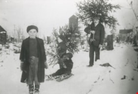
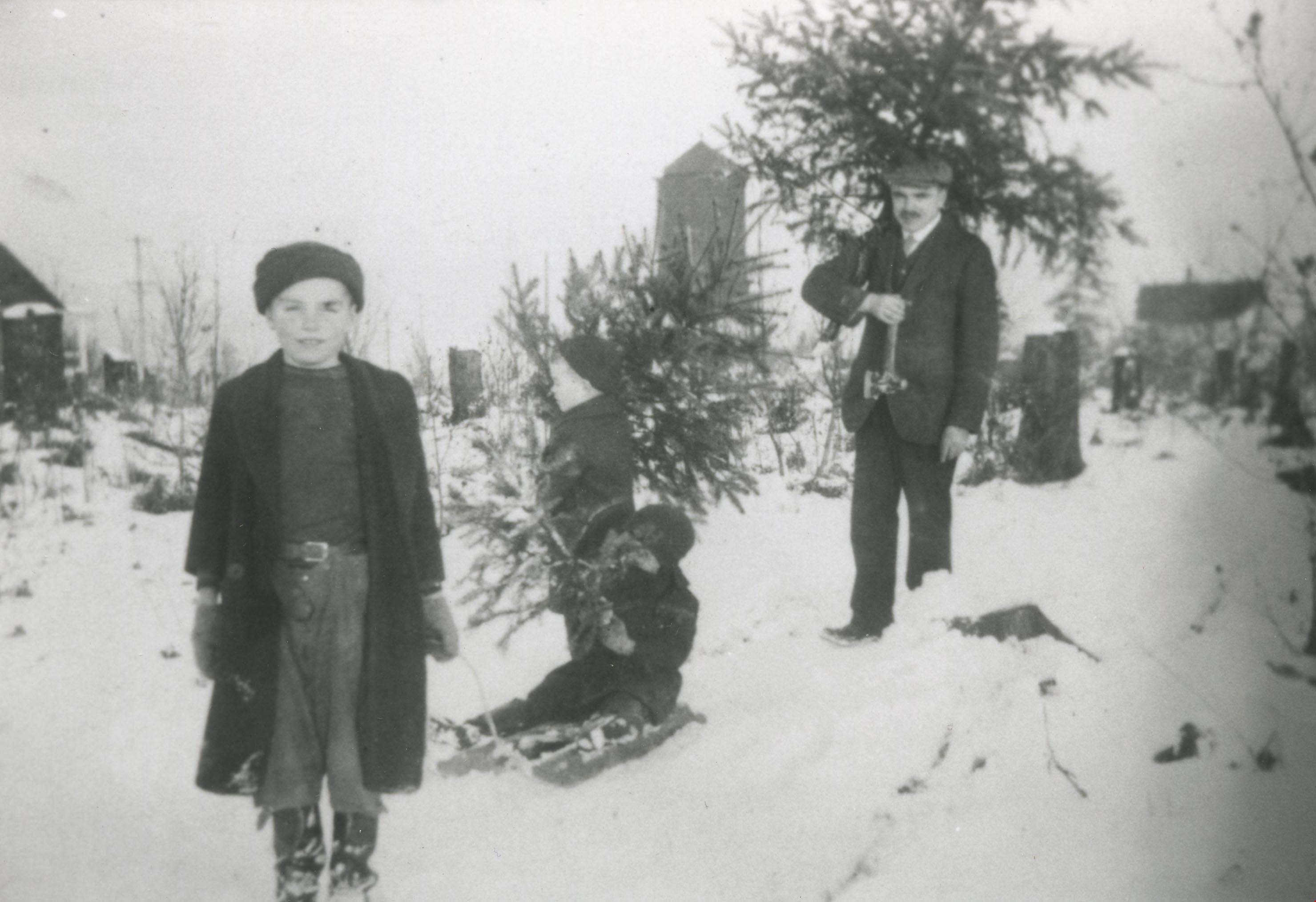
Grant family getting Christmas trees
https://search.heritageburnaby.ca/link/archivedescription36868
- Repository
- City of Burnaby Archives
- Date
- 1920 (date of original), copied 1992
- Collection/Fonds
- Burnaby Historical Society fonds
- Description Level
- Item
- Physical Description
- 1 photograph : b&w ; 8.7 x 12.6 cm print
- Scope and Content
- Photograph of George A. Grant and three children getting three Christmas trees from the bush between Marlborough Avenue and Royal Oak Road. The smallest child is sitting on a sled. There were five Grant children: William "Bill," George, Heriot "Harry," Millie, and Alastair.
- Repository
- City of Burnaby Archives
- Date
- 1920 (date of original), copied 1992
- Collection/Fonds
- Burnaby Historical Society fonds
- Subseries
- Burnaby Centennial Anthology subseries
- Physical Description
- 1 photograph : b&w ; 8.7 x 12.6 cm print
- Description Level
- Item
- Record No.
- 315-326
- Access Restriction
- No restrictions
- Reproduction Restriction
- No known restrictions
- Accession Number
- BHS1994-04
- Scope and Content
- Photograph of George A. Grant and three children getting three Christmas trees from the bush between Marlborough Avenue and Royal Oak Road. The smallest child is sitting on a sled. There were five Grant children: William "Bill," George, Heriot "Harry," Millie, and Alastair.
- Media Type
- Photograph
- Notes
- Title based on contents of photograph
- Geographic Access
- Marlborough Avenue
- Royal Oak Avenue
- Historic Neighbourhood
- Central Park (Historic Neighbourhood)
- Planning Study Area
- Marlborough Area
Images

The Green Timbers
https://search.heritageburnaby.ca/link/archivedescription34299
- Repository
- City of Burnaby Archives
- Date
- 1923
- Collection/Fonds
- Burnaby Historical Society fonds
- Description Level
- Item
- Physical Description
- 1 photograph : b&w ; 12.2 x 7.5 cm on page 23.5 x 17.5 cm
- Scope and Content
- Photograph taken looking down a tree-lined road, and is labelled "The Green Timbers". An automobile is parked along the side of the road. The Green Timbers was a famous roadway that went through Surrey and by the 1920s it was known as the only remaining stretch of virgin forest all the way from Ca…
- Repository
- City of Burnaby Archives
- Date
- 1923
- Collection/Fonds
- Burnaby Historical Society fonds
- Subseries
- Peers family subseries
- Physical Description
- 1 photograph : b&w ; 12.2 x 7.5 cm on page 23.5 x 17.5 cm
- Description Level
- Item
- Record No.
- 020-006
- Access Restriction
- No restrictions
- Reproduction Restriction
- No known restrictions
- Accession Number
- BHS2007-04
- Scope and Content
- Photograph taken looking down a tree-lined road, and is labelled "The Green Timbers". An automobile is parked along the side of the road. The Green Timbers was a famous roadway that went through Surrey and by the 1920s it was known as the only remaining stretch of virgin forest all the way from California to British Columbia. In more recent years, this area in Surrey has been declared an urban forest park.
- Media Type
- Photograph
- Notes
- Title based on caption accompanying photograph
Images


The Green Timbers
https://search.heritageburnaby.ca/link/archivedescription34300
- Repository
- City of Burnaby Archives
- Date
- 1923
- Collection/Fonds
- Burnaby Historical Society fonds
- Description Level
- Item
- Physical Description
- 1 photograph : b&w ; 12.2 x 7.5 cm on page 23.5 x 17.5 cm
- Scope and Content
- Photograph is labelled "The Green Timbers" and shows a view looking down a tree-line road. The Green Timbers was a famous roadway that went through Surrey and by the 1920s it was known as the only remaining stretch of virgin forest all the way from California to British Columbia. In more recent ye…
- Repository
- City of Burnaby Archives
- Date
- 1923
- Collection/Fonds
- Burnaby Historical Society fonds
- Subseries
- Peers family subseries
- Physical Description
- 1 photograph : b&w ; 12.2 x 7.5 cm on page 23.5 x 17.5 cm
- Description Level
- Item
- Record No.
- 020-007
- Access Restriction
- No restrictions
- Reproduction Restriction
- No known restrictions
- Accession Number
- BHS2007-04
- Scope and Content
- Photograph is labelled "The Green Timbers" and shows a view looking down a tree-line road. The Green Timbers was a famous roadway that went through Surrey and by the 1920s it was known as the only remaining stretch of virgin forest all the way from California to British Columbia. In more recent years, this area in Surrey has been declared an urban forest park.
- Media Type
- Photograph
- Notes
- Title based on caption accompanying photograph
Images

![Herolz family and friends, [1920] (date of original), copied 1991 thumbnail](/media/hpo/_Data/_Archives_Images/_Unrestricted/370/370-567.jpg?width=280)
Herolz family and friends
https://search.heritageburnaby.ca/link/archivedescription37980
- Repository
- City of Burnaby Archives
- Date
- [1920] (date of original), copied 1991
- Collection/Fonds
- Burnaby Historical Society fonds
- Description Level
- Item
- Physical Description
- 1 photograph : b&w ; 4.2 x 2.8 cm print on contact sheet 20.7 x 26.2 cm
- Scope and Content
- Photograph of the Herolz family and friends at Deer Lake Drive. Deer Lake can be seen in the background.
- Repository
- City of Burnaby Archives
- Date
- [1920] (date of original), copied 1991
- Collection/Fonds
- Burnaby Historical Society fonds
- Subseries
- Burnaby Image Bank subseries
- Physical Description
- 1 photograph : b&w ; 4.2 x 2.8 cm print on contact sheet 20.7 x 26.2 cm
- Description Level
- Item
- Record No.
- 370-567
- Access Restriction
- No restrictions
- Reproduction Restriction
- No known restrictions
- Accession Number
- BHS1999-03
- Scope and Content
- Photograph of the Herolz family and friends at Deer Lake Drive. Deer Lake can be seen in the background.
- Subjects
- Plants - Trees
- Names
- Herolz family
- Media Type
- Photograph
- Notes
- Title based on contents of photograph
- 1 b&w copy negative accompanying
- Geographic Access
- Deer Lake
- Deer Lake Drive
- Historic Neighbourhood
- Burnaby Lake (Historic Neighbourhood)
- Planning Study Area
- Morley-Buckingham Area
Images
![Herolz family and friends, [1920] (date of original), copied 1991 thumbnail](/media/hpo/_Data/_Archives_Images/_Unrestricted/370/370-567.jpg)
![Jesse and Girlie, [ca. 1925] (date of original), copied 1989 thumbnail](/media/hpo/_Data/_BVM_Images/2018/2018_0041_0187_001.jpg?width=280)
Jesse and Girlie
https://search.heritageburnaby.ca/link/museumdescription10006
- Repository
- Burnaby Village Museum
- Date
- [ca. 1925] (date of original), copied 1989
- Collection/Fonds
- Burnaby Village Museum fonds
- Description Level
- Item
- Physical Description
- 1 photograph : b&w negative ; 35 mm
- Scope and Content
- Photograph of Jesse Love and his daughter Hannah (Girlie). They both are wearing straw hats and Jesse is smoking a pipe. They are standing on the grass outside of the Love family farmhouse which can be seen to the left. There are trees, a washing line and swing behind them. Girlie was the youngest …
- Repository
- Burnaby Village Museum
- Collection/Fonds
- Burnaby Village Museum fonds
- Series
- Jesse Love farmhouse series
- Subseries
- Love family photographs subseries
- Description Level
- Item
- Physical Description
- 1 photograph : b&w negative ; 35 mm
- Scope and Content
- Photograph of Jesse Love and his daughter Hannah (Girlie). They both are wearing straw hats and Jesse is smoking a pipe. They are standing on the grass outside of the Love family farmhouse which can be seen to the left. There are trees, a washing line and swing behind them. Girlie was the youngest of eleven of the Love children. She continued to live in the house with her father until he died in 1928.
- Accession Code
- BV018.41.187
- Access Restriction
- No restrictions
- Reproduction Restriction
- May be restricted by third party rights
- Date
- [ca. 1925] (date of original), copied 1989
- Media Type
- Photograph
- Scan Resolution
- 2400
- Scan Date
- 4-Mar-2019
- Scale
- 100
- Notes
- Title based on contents of photograph
- 1 b&w copy print accompanying
Images
![Jesse and Girlie, [ca. 1925] (date of original), copied 1989 thumbnail](/media/hpo/_Data/_BVM_Images/2018/2018_0041_0187_001.jpg)
![Large stump, [192-] thumbnail](/media/hpo/_Data/_Archives_Images/_Unrestricted/251/267-004.jpg?width=280)
Large stump
https://search.heritageburnaby.ca/link/archivedescription36423
- Repository
- City of Burnaby Archives
- Date
- [192-]
- Collection/Fonds
- Burnaby Historical Society fonds
- Description Level
- Item
- Physical Description
- 1 photograph : col. ; 6 x 10 cm print
- Scope and Content
- Photograph of a boy leaning on a tree next to a very large stump at Piper Avenue and Government Road.
- Repository
- City of Burnaby Archives
- Date
- [192-]
- Collection/Fonds
- Burnaby Historical Society fonds
- Subseries
- Photographs subseries
- Physical Description
- 1 photograph : col. ; 6 x 10 cm print
- Description Level
- Item
- Record No.
- 267-004
- Access Restriction
- No restrictions
- Reproduction Restriction
- No known restrictions
- Accession Number
- BHS1991-34
- Scope and Content
- Photograph of a boy leaning on a tree next to a very large stump at Piper Avenue and Government Road.
- Subjects
- Plants - Trees
- Media Type
- Photograph
- Notes
- Title based on contents of photograph
- Print is a colour copy of a sepia original
- Geographic Access
- Government Road
- Piper Avenue
- Historic Neighbourhood
- Central Park (Historic Neighbourhood)
- Planning Study Area
- Maywood Area
Images
![Large stump, [192-] thumbnail](/media/hpo/_Data/_Archives_Images/_Unrestricted/251/267-004.jpg)

Lillias Urquhart
https://search.heritageburnaby.ca/link/archivedescription35281
- Repository
- City of Burnaby Archives
- Date
- 1929 (date of original), copied 1986
- Collection/Fonds
- Burnaby Historical Society fonds
- Description Level
- Item
- Physical Description
- 1 photograph : b&w ; 12.7 x 17.8 cm print
- Scope and Content
- Photograph of Mrs. Lillias Urquhart in the garden at "Rowanlea," the family home. Rowan trees line the street alongside telephone poles. Lillias Urquhart was married to William Urquhart. The house was previously numbered 2674, then changed to 6625, and later 6637 Griffiths Avenue.
- Repository
- City of Burnaby Archives
- Date
- 1929 (date of original), copied 1986
- Collection/Fonds
- Burnaby Historical Society fonds
- Subseries
- Pioneer Tales subseries
- Physical Description
- 1 photograph : b&w ; 12.7 x 17.8 cm print
- Description Level
- Item
- Record No.
- 204-138
- Access Restriction
- No restrictions
- Reproduction Restriction
- No known restrictions
- Accession Number
- BHS1988-03
- Scope and Content
- Photograph of Mrs. Lillias Urquhart in the garden at "Rowanlea," the family home. Rowan trees line the street alongside telephone poles. Lillias Urquhart was married to William Urquhart. The house was previously numbered 2674, then changed to 6625, and later 6637 Griffiths Avenue.
- Subjects
- Plants - Trees
- Names
- Urquhart, Lillias
- Media Type
- Photograph
- Notes
- Title based on contents of photograph
- Geographic Access
- Griffiths Avenue
- Street Address
- 6637 Griffiths Avenue
- Historic Neighbourhood
- Edmonds (Historic Neighbourhood)
- Planning Study Area
- Kingsway-Beresford Area
Images
Mr. Tough and G.L. Lawson beside a tree stump
https://search.heritageburnaby.ca/link/archivedescription38544
- Repository
- City of Burnaby Archives
- Date
- 1921
- Collection/Fonds
- Burnaby Historical Society fonds
- Description Level
- Item
- Physical Description
- 1 photograph : b&w ; 6 x 10.8 cm
- Scope and Content
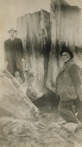
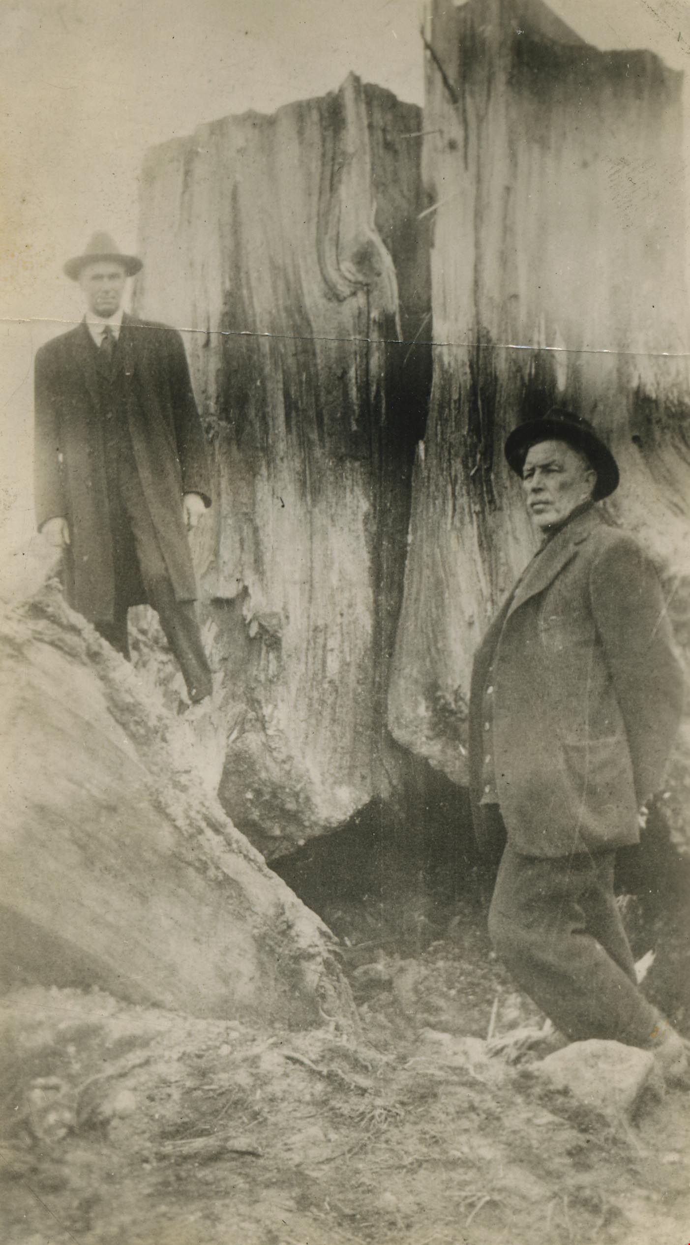
- Photograph of two men standing next to a large tree stump. A note written on the back of the photograph reads: " Stump blasted out by William Tough, street sup't [sic] in 1921. It stood on the boulevard on the south side of Hastings Street a few feet East of Ingleton. At left Councillor G. L. La…
- Repository
- City of Burnaby Archives
- Date
- 1921
- Collection/Fonds
- Burnaby Historical Society fonds
- Subseries
- New Westminster Public Library subseries
- Physical Description
- 1 photograph : b&w ; 6 x 10.8 cm
- Description Level
- Item
- Record No.
- 459-004
- Access Restriction
- No restrictions
- Reproduction Restriction
- No known restrictions
- Accession Number
- BHS2003-19
- Scope and Content
- Photograph of two men standing next to a large tree stump. A note written on the back of the photograph reads: " Stump blasted out by William Tough, street sup't [sic] in 1921. It stood on the boulevard on the south side of Hastings Street a few feet East of Ingleton. At left Councillor G. L. Lawson. Right, Mr. Tough." Councillor Lawson served on council from 1919-1920 and again from 1922-1923.
- Media Type
- Photograph
- Notes
- Title based on caption
- Geographic Access
- Hastings Street
- Ingleton Avenue
- Street Address
- 3900 Hastings Street
- Historic Neighbourhood
- Vancouver Heights (Historic Neighbourhood)
- Planning Study Area
- Willingdon Heights Area
Images
![Murdock McMurray and Amy Leigh, [1920] (date of original), copied 1976 thumbnail](/media/hpo/_Data/_BVM_Images/1976/1976_0041_0005_001.jpg?width=280)
Murdock McMurray and Amy Leigh
https://search.heritageburnaby.ca/link/museumdescription11935
- Repository
- Burnaby Village Museum
- Date
- [1920] (date of original), copied 1976
- Collection/Fonds
- Burnaby Village Museum Photograph collection
- Description Level
- Item
- Physical Description
- 1 photograph : b&w ; 20.2 x 25.3 cm print
- Scope and Content
- Photograph of Murdock McMurray and Amy Leigh in front of the hollow tree in Stanley Park, Vancouver.
- Repository
- Burnaby Village Museum
- Collection/Fonds
- Burnaby Village Museum Photograph collection
- Description Level
- Item
- Physical Description
- 1 photograph : b&w ; 20.2 x 25.3 cm print
- Scope and Content
- Photograph of Murdock McMurray and Amy Leigh in front of the hollow tree in Stanley Park, Vancouver.
- Subjects
- Plants - Trees
- Names
- McMurray, Murdoch
- Leigh, Amy
- Geographic Access
- Vancouver
- Accession Code
- HV976.41.5
- Access Restriction
- No restrictions
- Reproduction Restriction
- May be restricted by third party rights
- Date
- [1920] (date of original), copied 1976
- Media Type
- Photograph
- Scan Resolution
- 600
- Scan Date
- 2023-06-20
- Notes
- Title based on contents of photograph
Images
![Murdock McMurray and Amy Leigh, [1920] (date of original), copied 1976 thumbnail](/media/hpo/_Data/_BVM_Images/1976/1976_0041_0005_001.jpg)
Royal Anne cherry tree
https://search.heritageburnaby.ca/link/archivedescription35559
- Repository
- City of Burnaby Archives
- Date
- 1920 (date of original), copied 1986
- Collection/Fonds
- Burnaby Historical Society fonds
- Description Level
- Item
- Physical Description
- 1 photograph : b&w ; 12.7 x 17.8 cm print
- Scope and Content
- Photograph of a Royal Anne cherry tree in the backyard of the Cram orchard at 6515 Denbigh Avenue, on the northwest corner of Kingsway and Denbigh. The garage can be seen on the left. William Cram (father) would pick the cherries, and Mary Cram and Viola Cram (sisters) would load them in a wagon …
- Repository
- City of Burnaby Archives
- Date
- 1920 (date of original), copied 1986
- Collection/Fonds
- Burnaby Historical Society fonds
- Subseries
- Pioneer Tales subseries
- Physical Description
- 1 photograph : b&w ; 12.7 x 17.8 cm print
- Description Level
- Item
- Record No.
- 204-417
- Access Restriction
- No restrictions
- Reproduction Restriction
- No known restrictions
- Accession Number
- BHS1988-03
- Scope and Content
- Photograph of a Royal Anne cherry tree in the backyard of the Cram orchard at 6515 Denbigh Avenue, on the northwest corner of Kingsway and Denbigh. The garage can be seen on the left. William Cram (father) would pick the cherries, and Mary Cram and Viola Cram (sisters) would load them in a wagon and sell them, a chore which they did not like.
- Media Type
- Photograph
- Notes
- Title based on contents of photograph
- Geographic Access
- Denbigh Avenue
- Street Address
- 6515 Denbigh Avenue
- Historic Neighbourhood
- Central Park (Historic Neighbourhood)
- Planning Study Area
- Windsor Area
Images

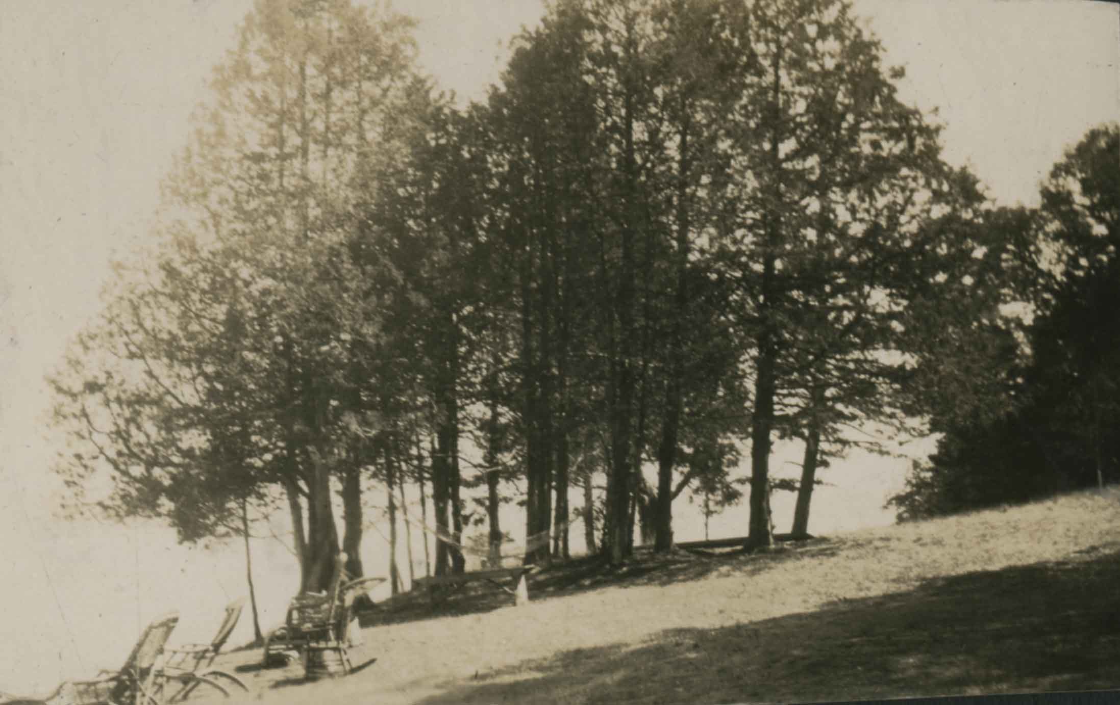
The Slope in Front of the Camp at Yellow Point
https://search.heritageburnaby.ca/link/archivedescription39398
- Repository
- City of Burnaby Archives
- Date
- 1923
- Collection/Fonds
- Peers Family and Hill Family fonds
- Description Level
- Item
- Physical Description
- 1 photograph : b&w ; 6 x 9.5 cm on page 24.5 x 32.5 cm (pasted in album)
- Scope and Content
- Photograph of a line of trees looking down towards the water. Beach chairs can be seen to the left.
- Repository
- City of Burnaby Archives
- Date
- 1923
- Collection/Fonds
- Peers Family and Hill Family fonds
- Physical Description
- 1 photograph : b&w ; 6 x 9.5 cm on page 24.5 x 32.5 cm (pasted in album)
- Description Level
- Item
- Record No.
- 477-717
- Access Restriction
- No restrictions
- Reproduction Restriction
- No known restrictions
- Accession Number
- 2007-12
- Scope and Content
- Photograph of a line of trees looking down towards the water. Beach chairs can be seen to the left.
- Subjects
- Plants - Trees
- Media Type
- Photograph
- Notes
- Title based on caption accompanying photograph
Images
![Stride family house, [1920] thumbnail](/media/hpo/_Data/_Archives_Images/_Unrestricted/001/001-003.jpg?width=280)
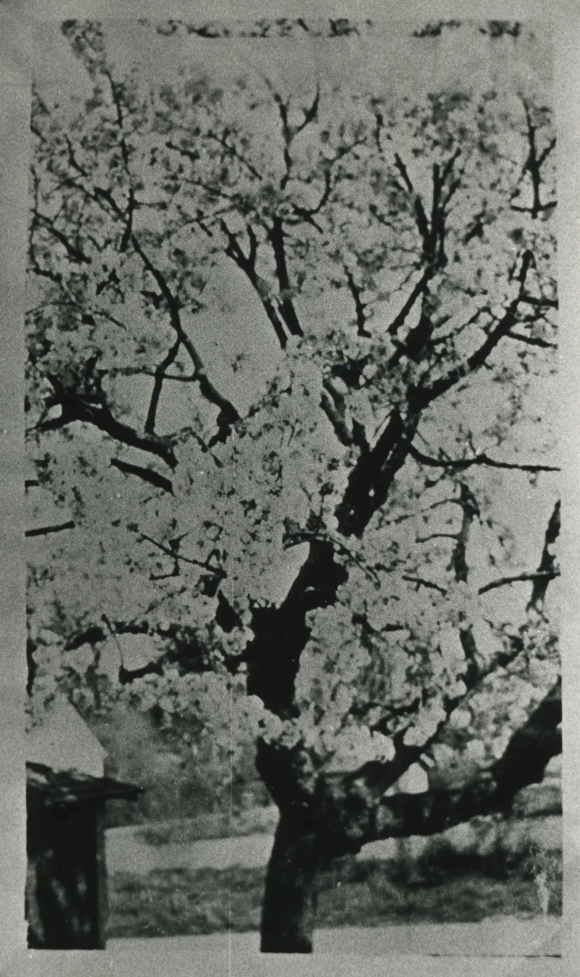
Stride family house
https://search.heritageburnaby.ca/link/archivedescription34027
- Repository
- City of Burnaby Archives
- Date
- [1920]
- Collection/Fonds
- Burnaby Historical Society fonds
- Description Level
- Item
- Physical Description
- 1 photograph : b&w ; 8.2 x 10.8 cm
- Scope and Content
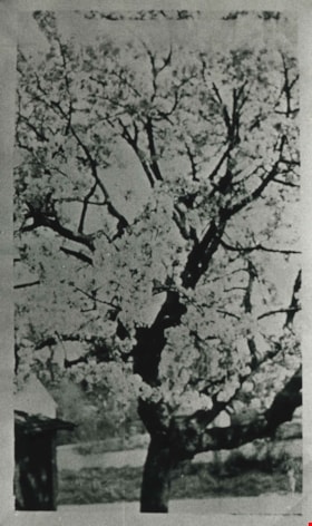
- Photograph of the Stride family house located at Kingsway and 18th Avenue. It is obscured by trees in blossom.
- Repository
- City of Burnaby Archives
- Date
- [1920]
- Collection/Fonds
- Burnaby Historical Society fonds
- Subseries
- Stride family subseries
- Physical Description
- 1 photograph : b&w ; 8.2 x 10.8 cm
- Description Level
- Item
- Record No.
- 001-003
- Access Restriction
- No restrictions
- Reproduction Restriction
- No known restrictions
- Accession Number
- BHS2007-04
- Scope and Content
- Photograph of the Stride family house located at Kingsway and 18th Avenue. It is obscured by trees in blossom.
- Media Type
- Photograph
- Notes
- Title based on contents of photograph
- Geographic Access
- Kingsway
- 18th Avenue
- Historic Neighbourhood
- Edmonds (Historic Neighbourhood)
Images
![Stride family house, [1920] thumbnail](/media/hpo/_Data/_Archives_Images/_Unrestricted/001/001-003.jpg)
![Toothpick stump at Gilmore Ave and Parker St, [1924] thumbnail](/media/hpo/_Data/_BVM_Images/1976/1976_0046_0003_001.jpg?width=280)
Toothpick stump at Gilmore Ave and Parker St
https://search.heritageburnaby.ca/link/museumdescription737
- Repository
- Burnaby Village Museum
- Date
- [1924]
- Collection/Fonds
- Burnaby Village Museum Photograph collection
- Description Level
- Item
- Physical Description
- 1 photograph : b&w ; 11.5 x 6.9 cm
- Scope and Content
- Photograph of a man sitting near the top of a giant tree stump at Willingdon Heights. According to an accompanying note prepared by Burnaby Village Museum and supported by the inscription on the photograph, the stump was at the southeast corner of Parker Street and Gilmore Avenue in the Willingdon…
- Repository
- Burnaby Village Museum
- Collection/Fonds
- Burnaby Village Museum Photograph collection
- Description Level
- Item
- Physical Description
- 1 photograph : b&w ; 11.5 x 6.9 cm
- Material Details
- Annotations on the front of the photograph read: "Gilmour & Parker. South. 1924" and "Toothpick Stump." An annotation on the back of the photograph reads, "Wide - 98 inch at TOB [sic - top] / Ground level 25 feet / SE corner of Parker & Gilmour / March 11 1971 / A Bingham."
- Scope and Content
- Photograph of a man sitting near the top of a giant tree stump at Willingdon Heights. According to an accompanying note prepared by Burnaby Village Museum and supported by the inscription on the photograph, the stump was at the southeast corner of Parker Street and Gilmore Avenue in the Willingdon Heights district.
- Subjects
- Plants - Trees
- Names
- Bingham, Alfred "Alf"
- Geographic Access
- Parker Street
- Gilmore Avenue
- Accession Code
- HV976.46.3
- Access Restriction
- No restrictions
- Reproduction Restriction
- No known restrictions
- Date
- [1924]
- Media Type
- Photograph
- Historic Neighbourhood
- Vancouver Heights (Historic Neighbourhood)
- Planning Study Area
- Willingdon Heights Area
- Scan Resolution
- 600
- Scan Date
- 2023-06-20
- Photographer
- Bingham, Alfred "Alf"
- Notes
- Title based on caption of photograph
Images
![Toothpick stump at Gilmore Ave and Parker St, [1924] thumbnail](/media/hpo/_Data/_BVM_Images/1976/1976_0046_0003_001.jpg)