Narrow Results By
Subject
- Advertising Medium - Signs and Signboards 1
- Agriculture - Farms 1
- Agriculture - Fruit and Berries 1
- Animals - Bears 1
- Animals - Birds 1
- Animals - Cats 1
- Animals - Deer 1
- Animals - Horses 1
- Buildings - Civic - Libraries 1
- Buildings - Residential 2
- Buildings - Residential - Houses 19
- Buildings - Schools 2

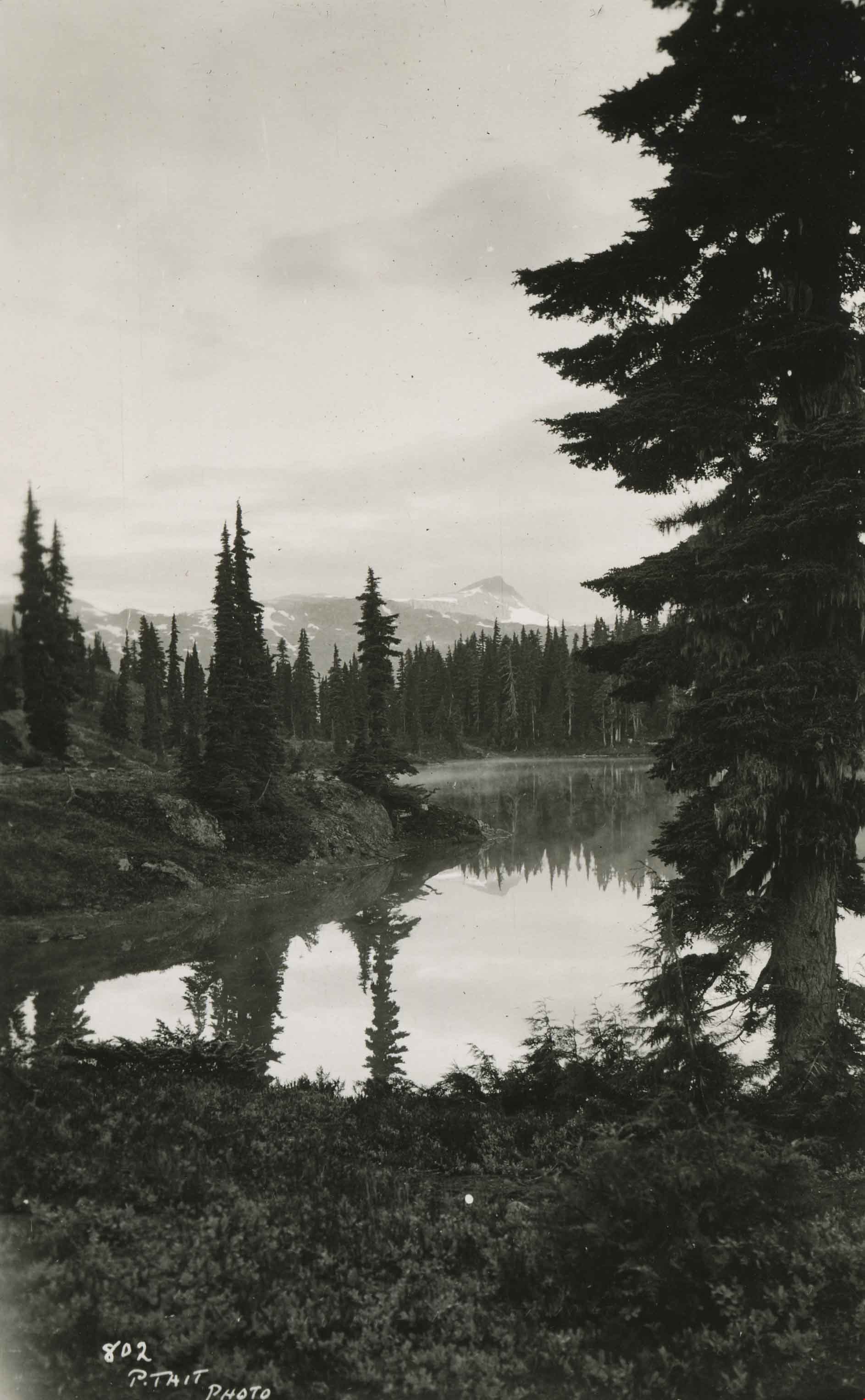
Lake within the Forbidden Plateau
https://search.heritageburnaby.ca/link/archivedescription51462
- Repository
- City of Burnaby Archives
- Date
- 1938
- Collection/Fonds
- Burnaby Historical Society fonds
- Description Level
- Item
- Physical Description
- 1 photograph : b&w postcard ; 13 x 8 cm
- Scope and Content
- Photographic postcard of a lake within the Forbidden Plateau on Vancouver Island. This was part of a trip made by a small party of City of Courtenay officials. George A. Grant was one of the climbers in the party.
- Repository
- City of Burnaby Archives
- Date
- 1938
- Collection/Fonds
- Burnaby Historical Society fonds
- Subseries
- George Grant subseries
- Physical Description
- 1 photograph : b&w postcard ; 13 x 8 cm
- Description Level
- Item
- Record No.
- 243-067
- Access Restriction
- No restrictions
- Reproduction Restriction
- No known restrictions
- Accession Number
- BHS1990-06
- Scope and Content
- Photographic postcard of a lake within the Forbidden Plateau on Vancouver Island. This was part of a trip made by a small party of City of Courtenay officials. George A. Grant was one of the climbers in the party.
- Media Type
- Photograph
- Photographer
- Tait, Preston L.
- Notes
- Title based on contents of photograph
- Photographer identifies photograph as no. 802
Images
![Large stump, [192-] thumbnail](/media/hpo/_Data/_Archives_Images/_Unrestricted/251/267-004.jpg?width=280)
Large stump
https://search.heritageburnaby.ca/link/archivedescription36423
- Repository
- City of Burnaby Archives
- Date
- [192-]
- Collection/Fonds
- Burnaby Historical Society fonds
- Description Level
- Item
- Physical Description
- 1 photograph : col. ; 6 x 10 cm print
- Scope and Content
- Photograph of a boy leaning on a tree next to a very large stump at Piper Avenue and Government Road.
- Repository
- City of Burnaby Archives
- Date
- [192-]
- Collection/Fonds
- Burnaby Historical Society fonds
- Subseries
- Photographs subseries
- Physical Description
- 1 photograph : col. ; 6 x 10 cm print
- Description Level
- Item
- Record No.
- 267-004
- Access Restriction
- No restrictions
- Reproduction Restriction
- No known restrictions
- Accession Number
- BHS1991-34
- Scope and Content
- Photograph of a boy leaning on a tree next to a very large stump at Piper Avenue and Government Road.
- Subjects
- Plants - Trees
- Media Type
- Photograph
- Notes
- Title based on contents of photograph
- Print is a colour copy of a sepia original
- Geographic Access
- Government Road
- Piper Avenue
- Historic Neighbourhood
- Central Park (Historic Neighbourhood)
- Planning Study Area
- Maywood Area
Images
![Large stump, [192-] thumbnail](/media/hpo/_Data/_Archives_Images/_Unrestricted/251/267-004.jpg)
![Letter carrier under blossoms, [2001] thumbnail](/media/hpo/_Data/_Archives_Images/_Unrestricted/535/535-1645.jpg?width=280)
Letter carrier under blossoms
https://search.heritageburnaby.ca/link/archivedescription95822
- Repository
- City of Burnaby Archives
- Date
- [2001]
- Collection/Fonds
- Burnaby NewsLeader photograph collection
- Description Level
- Item
- Physical Description
- 1 photograph (tiff) : col.
- Scope and Content
- Photograph of a letter carrier walking underneath trees with pink spring blossoms.
- Repository
- City of Burnaby Archives
- Date
- [2001]
- Collection/Fonds
- Burnaby NewsLeader photograph collection
- Physical Description
- 1 photograph (tiff) : col.
- Description Level
- Item
- Record No.
- 535-1645
- Access Restriction
- No restrictions
- Reproduction Restriction
- No restrictions
- Accession Number
- 2018-12
- Scope and Content
- Photograph of a letter carrier walking underneath trees with pink spring blossoms.
- Subjects
- Occupations
- Plants - Trees
- Media Type
- Photograph
- Photographer
- Bartel, Mario
- Notes
- Title based on caption
- Collected by editorial for use in a February 2001 issue of the Burnaby NewsLeader
- Caption from metadata: "John Kirschmann , lettercarrier makes his way up Empire street in Burnaby where the first spring blossoms are out."
- Geographic Access
- Empire Drive
Images
![Letter carrier under blossoms, [2001] thumbnail](/media/hpo/_Data/_Archives_Images/_Unrestricted/535/535-1645.jpg)
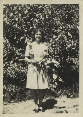
Lillian Carman
https://search.heritageburnaby.ca/link/archivedescription77810
- Repository
- City of Burnaby Archives
- Date
- 1944
- Collection/Fonds
- Yanko family fonds
- Description Level
- Item
- Physical Description
- 1 photograph : b&w ; 8 x 5.5 cm
- Scope and Content
- Photograph of Leida Doria "Lillian Doris" Carman (later Yanko) standing near an apple tree in Nelson, British Columbia.
- Repository
- City of Burnaby Archives
- Date
- 1944
- Collection/Fonds
- Yanko family fonds
- Physical Description
- 1 photograph : b&w ; 8 x 5.5 cm
- Material Details
- Secured to album page with photo corners
- Description Level
- Item
- Record No.
- 545-045
- Access Restriction
- No restrictions
- Reproduction Restriction
- No known restrictions
- Accession Number
- 2012-09
- Scope and Content
- Photograph of Leida Doria "Lillian Doris" Carman (later Yanko) standing near an apple tree in Nelson, British Columbia.
- Subjects
- Plants - Trees
- Media Type
- Photograph
- Notes
- Title based on contents of photograph
- Note in pencil on verso of photograph reads: "Lillian Carman Yanko / apple tree / Nelson"
- Note written on album page reads: "1944 / Lillian - Apple Tree - Nelson, BC"
- Note in blue ink on verso of photograph reads: "1944"
Images


Lillias Urquhart
https://search.heritageburnaby.ca/link/archivedescription35281
- Repository
- City of Burnaby Archives
- Date
- 1929 (date of original), copied 1986
- Collection/Fonds
- Burnaby Historical Society fonds
- Description Level
- Item
- Physical Description
- 1 photograph : b&w ; 12.7 x 17.8 cm print
- Scope and Content
- Photograph of Mrs. Lillias Urquhart in the garden at "Rowanlea," the family home. Rowan trees line the street alongside telephone poles. Lillias Urquhart was married to William Urquhart. The house was previously numbered 2674, then changed to 6625, and later 6637 Griffiths Avenue.
- Repository
- City of Burnaby Archives
- Date
- 1929 (date of original), copied 1986
- Collection/Fonds
- Burnaby Historical Society fonds
- Subseries
- Pioneer Tales subseries
- Physical Description
- 1 photograph : b&w ; 12.7 x 17.8 cm print
- Description Level
- Item
- Record No.
- 204-138
- Access Restriction
- No restrictions
- Reproduction Restriction
- No known restrictions
- Accession Number
- BHS1988-03
- Scope and Content
- Photograph of Mrs. Lillias Urquhart in the garden at "Rowanlea," the family home. Rowan trees line the street alongside telephone poles. Lillias Urquhart was married to William Urquhart. The house was previously numbered 2674, then changed to 6625, and later 6637 Griffiths Avenue.
- Subjects
- Plants - Trees
- Names
- Urquhart, Lillias
- Media Type
- Photograph
- Notes
- Title based on contents of photograph
- Geographic Access
- Griffiths Avenue
- Street Address
- 6637 Griffiths Avenue
- Historic Neighbourhood
- Edmonds (Historic Neighbourhood)
- Planning Study Area
- Kingsway-Beresford Area
Images
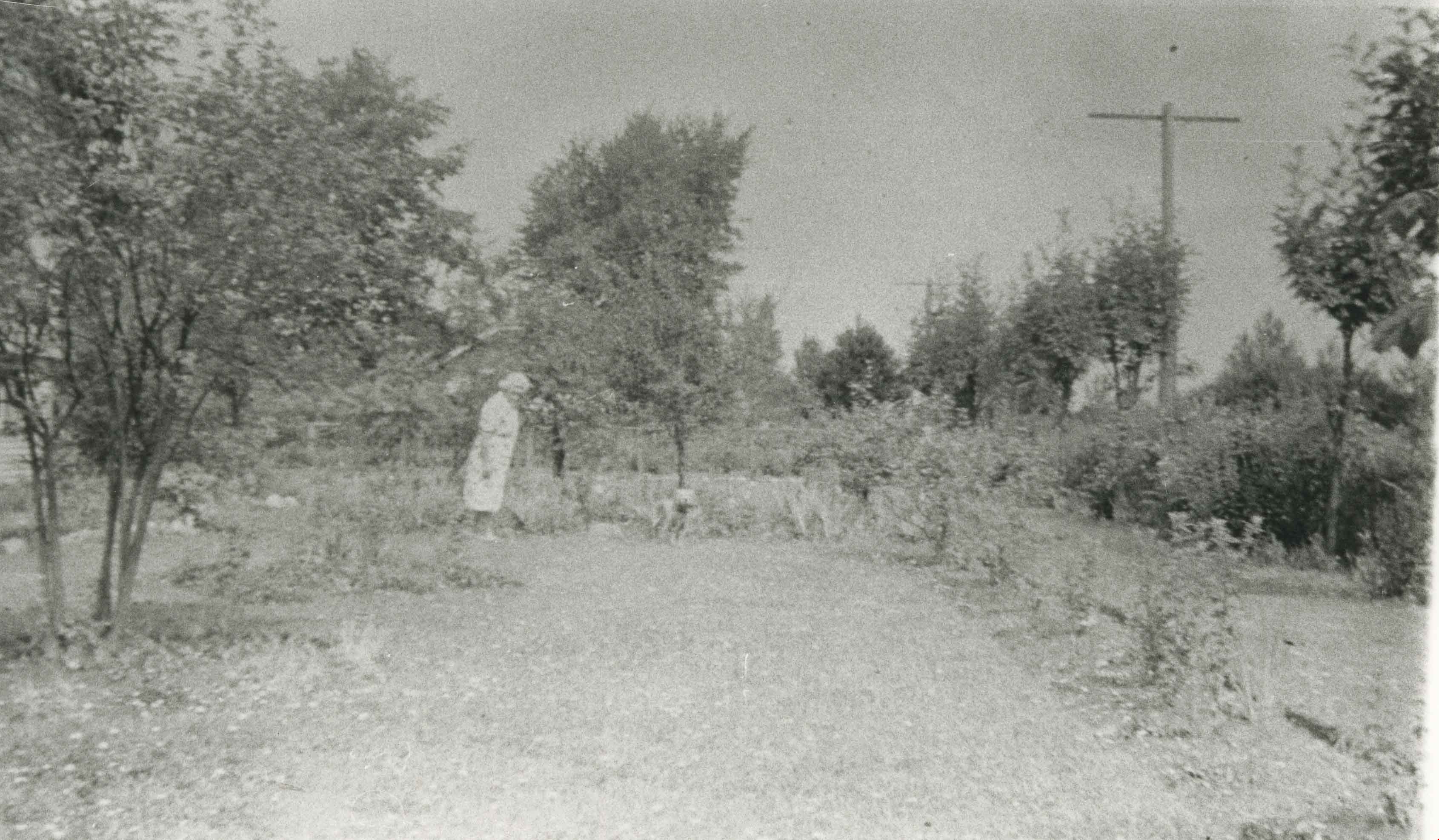

Linden Avenue
https://search.heritageburnaby.ca/link/archivedescription35000
- Repository
- City of Burnaby Archives
- Date
- 1908 (date of original), copied 1986
- Collection/Fonds
- Burnaby Historical Society fonds
- Description Level
- Item
- Physical Description
- 1 photograph : b&w ; 8.8 x 12.5 cm print
- Scope and Content
- Photograph of trees and stumps on Linden Avenue, Edmonds District. The caption at the bottom right of the photograph reads, "Linden Ave. / Edmonds 1908."
- Repository
- City of Burnaby Archives
- Date
- 1908 (date of original), copied 1986
- Collection/Fonds
- Burnaby Historical Society fonds
- Subseries
- Patterson family subseries
- Physical Description
- 1 photograph : b&w ; 8.8 x 12.5 cm print
- Description Level
- Item
- Record No.
- 171-021
- Access Restriction
- No restrictions
- Reproduction Restriction
- No known restrictions
- Accession Number
- BHS1986-20
- Scope and Content
- Photograph of trees and stumps on Linden Avenue, Edmonds District. The caption at the bottom right of the photograph reads, "Linden Ave. / Edmonds 1908."
- Media Type
- Photograph
- Geographic Access
- Linden Avenue
- Historic Neighbourhood
- Edmonds (Historic Neighbourhood)
- Planning Study Area
- Richmond Park Area
Images


Looking east along Dominion street to corner of Douglas Road and Dominion Street
https://search.heritageburnaby.ca/link/archivedescription91875
- Repository
- City of Burnaby Archives
- Date
- 1991
- Collection/Fonds
- Small family fonds
- Description Level
- Item
- Physical Description
- 1 photograph : col. copy print ; 10 cm x 15 cm
- Scope and Content
- Photograph of houses along Dominion Street, looking east with a tall hemlock, fir, and oak tree in the background. These houses were built after the Roberts' house was moved from 5538 Dominion Street to 5496 Dominion Street in 1982. The trees are the only three remaining from the original landsca…
- Repository
- City of Burnaby Archives
- Date
- 1991
- Collection/Fonds
- Small family fonds
- Physical Description
- 1 photograph : col. copy print ; 10 cm x 15 cm
- Description Level
- Item
- Record No.
- 620-056
- Access Restriction
- No restrictions
- Reproduction Restriction
- No reproduction permitted
- Accession Number
- 2017-01
- Scope and Content
- Photograph of houses along Dominion Street, looking east with a tall hemlock, fir, and oak tree in the background. These houses were built after the Roberts' house was moved from 5538 Dominion Street to 5496 Dominion Street in 1982. The trees are the only three remaining from the original landscaping of the Roberts' property in the late 1920s. The photograph was taken from the north side of the street, opposite 5496 Dominion Street.
- Media Type
- Photograph
- Notes
- Transcribed title
- Title transcribed from donor's notes
- Note in blue ink on verso of photograph reads: "P.18"
- Note in blue ink on verso of photograph reads: "Dominion St Summer 1991"
- The oak tree is the same tree as in photographs 620-007, 620-014, 620-015, and 620-016
- Geographic Access
- Dominion Street
- Street Address
- 5538 Dominion Street
- Historic Neighbourhood
- Burnaby Lake (Historic Neighbourhood)
- Planning Study Area
- Ardingley-Sprott Area
Images

Looking east along Dominion street to corner of Douglas Road and Dominion Street
https://search.heritageburnaby.ca/link/archivedescription91876
- Repository
- City of Burnaby Archives
- Date
- 2016
- Collection/Fonds
- Small family fonds
- Description Level
- Item
- Physical Description
- 1 photograph : col. ; 10 cm x 15 cm
- Scope and Content
- Photograph of Dominion Street, looking east. The houses are largely obscured by tall hedges and bushes. The photograph was taken from the north side of the street, opposite 5496 Dominion Street.
- Repository
- City of Burnaby Archives
- Date
- 2016
- Collection/Fonds
- Small family fonds
- Physical Description
- 1 photograph : col. ; 10 cm x 15 cm
- Description Level
- Item
- Record No.
- 620-057
- Access Restriction
- No restrictions
- Reproduction Restriction
- No reproduction permitted
- Accession Number
- 2017-01
- Scope and Content
- Photograph of Dominion Street, looking east. The houses are largely obscured by tall hedges and bushes. The photograph was taken from the north side of the street, opposite 5496 Dominion Street.
- Media Type
- Photograph
- Notes
- Transcribed title
- Title transcribed from donor's notes
- Note in blue ink on verso of photograph reads: "P.19"
- Note in blue ink on verso of photograph reads: "2016 / Looking East along Dominion St to corner of Douglas Rd. and Dominion St."
- Photograph 620-056 taken from the same vantage point
- Geographic Access
- Dominion Street
- Street Address
- 5538 Dominion Street
- Historic Neighbourhood
- Burnaby Lake (Historic Neighbourhood)
- Planning Study Area
- Ardingley-Sprott Area
Images


Looking east from 3131 Douglas Road
https://search.heritageburnaby.ca/link/archivedescription91826
- Repository
- City of Burnaby Archives
- Date
- January 2016
- Collection/Fonds
- Small family fonds
- Description Level
- Item
- Physical Description
- 1 photograph : col. copy print ; 15 cm x 10 cm
- Scope and Content
- Photograph of the Roberts' front yard . A large oak tree stands in the centre of the photograph with a row of short shrubs on each side. The house located at 3090 Douglas Road is visible in the distance. The photograph is taken from 3131 Douglas Road, looking east.
- Repository
- City of Burnaby Archives
- Date
- January 2016
- Collection/Fonds
- Small family fonds
- Physical Description
- 1 photograph : col. copy print ; 15 cm x 10 cm
- Description Level
- Item
- Record No.
- 620-007
- Access Restriction
- No restrictions
- Reproduction Restriction
- No reproduction permitted
- Accession Number
- 2017-01
- Scope and Content
- Photograph of the Roberts' front yard . A large oak tree stands in the centre of the photograph with a row of short shrubs on each side. The house located at 3090 Douglas Road is visible in the distance. The photograph is taken from 3131 Douglas Road, looking east.
- Media Type
- Photograph
- Notes
- Transcribed title
- Title transcribed from donor's notes
- 5118 Douglas Road renumbered to 3131 Douglas Road in 1958 and to 5538 Dominion Street in 1970 or 1971
- Note in blue ink on verso of photograph reads: "Jan. 2016 / Looking East from Roberts' front yard"
- Note in blue ink on verso of photograph reads: "P8"
- Photograph 620-003 depicts the same house on 3090 Douglas Road.
- Street Address
- 3131 Douglas Road
- 5118 Douglas Road
- 5538 Dominion Street
- 3090 Douglas Road
- Historic Neighbourhood
- Burnaby Lake (Historic Neighbourhood)
- Planning Study Area
- Ardingley-Sprott Area
Images


Looking east from north side of 5118 Douglas Road - The Roberts House
https://search.heritageburnaby.ca/link/archivedescription91825
- Repository
- City of Burnaby Archives
- Date
- 1971
- Collection/Fonds
- Small family fonds
- Description Level
- Item
- Physical Description
- 1 photograph : col. copy print ; 15 cm x 10 cm
- Scope and Content
- Photograph of the foliage, planted in the late 1920s, in the Roberts' front yard. The photograph was taken from the north side of the Roberts' property at 3131 Douglas Road, looking east.
- Repository
- City of Burnaby Archives
- Date
- 1971
- Collection/Fonds
- Small family fonds
- Physical Description
- 1 photograph : col. copy print ; 15 cm x 10 cm
- Description Level
- Item
- Record No.
- 620-006
- Access Restriction
- No restrictions
- Reproduction Restriction
- No reproduction permitted
- Accession Number
- 2017-01
- Scope and Content
- Photograph of the foliage, planted in the late 1920s, in the Roberts' front yard. The photograph was taken from the north side of the Roberts' property at 3131 Douglas Road, looking east.
- Media Type
- Photograph
- Notes
- Transcribed title
- Title transcribed from donor's notes
- 5118 Douglas Road renumbered to 3131 Douglas Road in 1958 and to 5538 Dominion Street in 1970 or 1971
- Note in blue ink on verso of photograph reads: "1971 / Looking East from Roberts' front yard""
- Note in blue ink on verso of photograph reads: "P7"
- Street Address
- 3131 Douglas Road
- 5118 Douglas Road
- 5538 Dominion Street
- Historic Neighbourhood
- Burnaby Lake (Historic Neighbourhood)
- Planning Study Area
- Ardingley-Sprott Area
Images


Looking northwest from Douglas Road
https://search.heritageburnaby.ca/link/archivedescription91835
- Repository
- City of Burnaby Archives
- Date
- October 2015
- Collection/Fonds
- Small family fonds
- Description Level
- Item
- Physical Description
- 1 photograph : col. copy print ; 10 cm x 15 cm
- Scope and Content
- Photograph of a two-storey house located at 3131 Douglas Road. The house is white with brown trim and a brown shingle roof. The large oak tree in the front yard of the property is full of vibrant autum-coloured leaves. The photograph was taken from across Douglas Road, looking northwest.
- Repository
- City of Burnaby Archives
- Date
- October 2015
- Collection/Fonds
- Small family fonds
- Physical Description
- 1 photograph : col. copy print ; 10 cm x 15 cm
- Description Level
- Item
- Record No.
- 620-016
- Access Restriction
- No restrictions
- Reproduction Restriction
- No reproduction permitted
- Accession Number
- 2017-01
- Scope and Content
- Photograph of a two-storey house located at 3131 Douglas Road. The house is white with brown trim and a brown shingle roof. The large oak tree in the front yard of the property is full of vibrant autum-coloured leaves. The photograph was taken from across Douglas Road, looking northwest.
- Media Type
- Photograph
- Notes
- Transcribed title
- Title transcribed from donor's notes
- Note in blue ink on verso of photograph reads: "Oct. 2016 / 3131 Douglas Rd. - with Oak Tree - Fall Colours"
- Note in blue ink on verso of photograph reads: "P.16"
- 5118 Douglas Road renumbered to 3131 Douglas Road in 1958 and to 5538 Dominion Street in 1970 or 1971
- The oak tree (centre) is the same tree as in photographs 620-007, 620-014, and 620-015
- Street Address
- 3131 Douglas Road
- 5118 Douglas Road
- 5538 Dominion Street
- Historic Neighbourhood
- Burnaby Lake (Historic Neighbourhood)
- Planning Study Area
- Ardingley-Sprott Area
Images


Looking southwest from corner of Douglas Road and Dominion Street
https://search.heritageburnaby.ca/link/archivedescription91877
- Repository
- City of Burnaby Archives
- Date
- 1978
- Collection/Fonds
- Small family fonds
- Description Level
- Item
- Physical Description
- 1 photograph : col. ; 9 cm x 13 cm
- Scope and Content
- Photograph of trees and a telephone pole situated at the southwest corner of Douglas Road and Dominion Street. The large oak, hemlock, and fir to the left of the telephone pole were planted as part of the original landscaping of the Roberts' property in the 1920s. The photograph was taken from th…
- Repository
- City of Burnaby Archives
- Date
- 1978
- Collection/Fonds
- Small family fonds
- Physical Description
- 1 photograph : col. ; 9 cm x 13 cm
- Description Level
- Item
- Record No.
- 620-058
- Access Restriction
- No restrictions
- Reproduction Restriction
- No reproduction permitted
- Accession Number
- 2017-01
- Scope and Content
- Photograph of trees and a telephone pole situated at the southwest corner of Douglas Road and Dominion Street. The large oak, hemlock, and fir to the left of the telephone pole were planted as part of the original landscaping of the Roberts' property in the 1920s. The photograph was taken from the Douglas Road and Dominion Street intersection.
- Media Type
- Photograph
- Notes
- Transcribed title
- Title transcribed from donor's notes
- Note in blue ink on verso of photograph reads: "P.20"
- Note in blue ink on verso of photograph reads: "Photo 1978"
- Note in black ink on verso of photograph reads: "Looking at S.W. corner of Douglas Rd and Dominion Street, from intersection / Oak tree, hemlock tree, and fir tree, Japanese Plum Tree"
- The oak tree is the same tree as in photographs 620-007, 620-014, 620-015, and 620-016
- Geographic Access
- Dominion Street
- Douglas Road
- Historic Neighbourhood
- Burnaby Lake (Historic Neighbourhood)
- Planning Study Area
- Ardingley-Sprott Area
Images


Looking southwest from corner of Douglas Road and Dominion Street
https://search.heritageburnaby.ca/link/archivedescription91878
- Repository
- City of Burnaby Archives
- Date
- April 2015
- Collection/Fonds
- Small family fonds
- Description Level
- Item
- Physical Description
- 1 photograph : col. copy print ; 10 cm x 15 cm
- Scope and Content
- Photograph of the houses and trees situated on the southwest corner of Douglas Road and Dominion Street. The large oak, hemlock, and fir were planted as part of the original landscaping of the Roberts' property in the 1920s. The photograph was taken from the Douglas Road and Dominion Street inter…
- Repository
- City of Burnaby Archives
- Date
- April 2015
- Collection/Fonds
- Small family fonds
- Physical Description
- 1 photograph : col. copy print ; 10 cm x 15 cm
- Description Level
- Item
- Record No.
- 620-059
- Access Restriction
- No restrictions
- Reproduction Restriction
- No reproduction permitted
- Accession Number
- 2017-01
- Scope and Content
- Photograph of the houses and trees situated on the southwest corner of Douglas Road and Dominion Street. The large oak, hemlock, and fir were planted as part of the original landscaping of the Roberts' property in the 1920s. The photograph was taken from the Douglas Road and Dominion Street intersection.
- Media Type
- Photograph
- Notes
- Transcribed title
- Title transcribed from donor's notes
- Note in blue ink on verso of photograph reads: "P.21"
- Note in blue ink on verso of photograph reads: "Looking southwest from corner of Douglas Rd. and Dominion St. / Oak Tree Hemlock Tree Fir Tree / planted in late 1920's"
- Note in black ink on verso of photograph reads: "April 2015"
- The oak tree is the same tree as in photographs 620-007, 620-014, 620-015, and 620-016
- Geographic Access
- Dominion Street
- Douglas Road
- Historic Neighbourhood
- Burnaby Lake (Historic Neighbourhood)
- Planning Study Area
- Ardingley-Sprott Area
Images


Looking west from Douglas Road
https://search.heritageburnaby.ca/link/archivedescription91827
- Repository
- City of Burnaby Archives
- Date
- September 1934
- Collection/Fonds
- Small family fonds
- Description Level
- Item
- Physical Description
- 1 photograph : sepia ; 7.5 cm x 8.5 cm
- Scope and Content
- Photograph of the Roberts' house on 5118 Douglas Road, taken from across the street. Edward and Roland Roberts are seated on the lawn behind a hedge and in front of the house. To the left is the house located at 5106 Douglas Road, built by John W. Roberts and then subsequently sold.
- Repository
- City of Burnaby Archives
- Date
- September 1934
- Collection/Fonds
- Small family fonds
- Physical Description
- 1 photograph : sepia ; 7.5 cm x 8.5 cm
- Description Level
- Item
- Record No.
- 620-008
- Access Restriction
- No restrictions
- Reproduction Restriction
- No known restrictions
- Accession Number
- 2017-01
- Scope and Content
- Photograph of the Roberts' house on 5118 Douglas Road, taken from across the street. Edward and Roland Roberts are seated on the lawn behind a hedge and in front of the house. To the left is the house located at 5106 Douglas Road, built by John W. Roberts and then subsequently sold.
- Media Type
- Photograph
- Notes
- Transcribed title
- Title transcribed from donor's notes
- 5118 Douglas Road renumbered to 3131 Douglas Road in 1958 and to 5538 Dominion Street in 1970 or 1971
- 5106 Douglas Road later subdivided into 5539 and 5545 Norfolk Street.
- Note in black ink on verso of photograph reads: "Sept. 1934 / Our house on Douglas Road"
- Note in blue ink on verso of photograph reads: "P9"
- Street Address
- 3131 Douglas Road
- 5118 Douglas Road
- 5538 Dominion Street
- 5106 Douglas Road
- Historic Neighbourhood
- Burnaby Lake (Historic Neighbourhood)
- Planning Study Area
- Ardingley-Sprott Area
Images

Looking west from Douglas Road
https://search.heritageburnaby.ca/link/archivedescription91828
- Repository
- City of Burnaby Archives
- Date
- 1978
- Collection/Fonds
- Small family fonds
- Description Level
- Item
- Physical Description
- 1 photograph : col. 8 cm x 12 cm
- Scope and Content
- Photograph of a light brown house located at 5106 Douglas Road. The house was built by J.W. Roberts and owned by the Meyers family from 1949 to 1993. The photograph was taken from Douglas Road, looking west, and the house is largely obscured by the trees in the yard.
- Repository
- City of Burnaby Archives
- Date
- 1978
- Collection/Fonds
- Small family fonds
- Physical Description
- 1 photograph : col. 8 cm x 12 cm
- Description Level
- Item
- Record No.
- 620-009
- Access Restriction
- No restrictions
- Reproduction Restriction
- No reproduction permitted
- Accession Number
- 2017-01
- Scope and Content
- Photograph of a light brown house located at 5106 Douglas Road. The house was built by J.W. Roberts and owned by the Meyers family from 1949 to 1993. The photograph was taken from Douglas Road, looking west, and the house is largely obscured by the trees in the yard.
- Media Type
- Photograph
- Notes
- Transcribed title
- Title transcribed from donor's notes
- 5106 Douglas Road later subdivided into 5539 and 5545 Norfolk Street.
- Note in blue ink on verso of photograph reads: "EA. Meyers Residence / Photo by Pat Meyers"
- Note in blue ink on verso of photograph reads: "1978?"
- Note in blue ink on verso of photograph reads: "P.10"
- Street Address
- 5106 Douglas Road
- Historic Neighbourhood
- Burnaby Lake (Historic Neighbourhood)
- Planning Study Area
- Ardingley-Sprott Area
Images

Looking west from Douglas Road
https://search.heritageburnaby.ca/link/archivedescription91833
- Repository
- City of Burnaby Archives
- Date
- 1991
- Collection/Fonds
- Small family fonds
- Description Level
- Item
- Physical Description
- 1 photograph : col. copy print ; 10 cm x 15 cm
- Scope and Content
- Photograph of the houses located on the corner of Douglas Road and Dominion Street, with large oak, hemlock, and fir trees in the yard. The house in the foreground is 3131 Douglas Road; the house in the background is 5536 Dominion Street. The photograph was taken from Douglas Street, looking west.
- Repository
- City of Burnaby Archives
- Date
- 1991
- Collection/Fonds
- Small family fonds
- Physical Description
- 1 photograph : col. copy print ; 10 cm x 15 cm
- Description Level
- Item
- Record No.
- 620-014
- Access Restriction
- No restrictions
- Reproduction Restriction
- No reproduction permitted
- Accession Number
- 2017-01
- Scope and Content
- Photograph of the houses located on the corner of Douglas Road and Dominion Street, with large oak, hemlock, and fir trees in the yard. The house in the foreground is 3131 Douglas Road; the house in the background is 5536 Dominion Street. The photograph was taken from Douglas Street, looking west.
- Media Type
- Photograph
- Notes
- Transcribed title
- Title transcribed from donor's notes
- Note in blue ink on verso of photograph reads: "Corner of Douglas Rd and Dominion St. with Oak Tree, Summer 1991"
- Note in blue ink on verso of photograph reads: "P14"
- 5118 Douglas Road renumbered to 3131 Douglas Road in 1958 and to 5538 Dominion Street in 1970 or 1971
- The oak tree (centre) is the same tree as in photograph 620-007
- Street Address
- 3131 Douglas Road
- 5118 Douglas Road
- 5538 Dominion Street
- Historic Neighbourhood
- Burnaby Lake (Historic Neighbourhood)
- Planning Study Area
- Ardingley-Sprott Area
Images


Looking west from Douglas Road
https://search.heritageburnaby.ca/link/archivedescription91834
- Repository
- City of Burnaby Archives
- Date
- April 2015
- Collection/Fonds
- Small family fonds
- Description Level
- Item
- Physical Description
- 1 photograph : col. copy print ; 10 cm x 15 cm
- Scope and Content
- Photograph of the houses located on the corner of Douglas Road and Dominion Street, with a large oak tree in the front of the yard. The house on the left is 3131 Douglas Road; the house behind is 5536 Dominion Street. The photograph was taken from Douglas Road, looking west.
- Repository
- City of Burnaby Archives
- Date
- April 2015
- Collection/Fonds
- Small family fonds
- Physical Description
- 1 photograph : col. copy print ; 10 cm x 15 cm
- Description Level
- Item
- Record No.
- 620-015
- Access Restriction
- No restrictions
- Reproduction Restriction
- No reproduction permitted
- Accession Number
- 2017-01
- Scope and Content
- Photograph of the houses located on the corner of Douglas Road and Dominion Street, with a large oak tree in the front of the yard. The house on the left is 3131 Douglas Road; the house behind is 5536 Dominion Street. The photograph was taken from Douglas Road, looking west.
- Media Type
- Photograph
- Notes
- Transcribed title
- Title transcribed from donor's notes
- Note in blue ink on verso of photograph reads: "April 2015 / 3131 Douglas Rd. / with Oak Tree"
- Note in blue ink on verso of photograph reads: "P.15"
- 5118 Douglas Road renumbered to 3131 Douglas Road in 1958 and to 5538 Dominion Street in 1970 or 1971
- The oak tree (centre) is the same tree as in photographs 620-007 and 620-014
- Street Address
- 3131 Douglas Road
- 5118 Douglas Road
- 5538 Dominion Street
- Historic Neighbourhood
- Burnaby Lake (Historic Neighbourhood)
- Planning Study Area
- Ardingley-Sprott Area
Images

![Lucy De Pieri tree planting at Burnaby Lake, [2002] thumbnail](/media/hpo/_Data/_Archives_Images/_Unrestricted/535/535-2805.jpg?width=280)
Lucy De Pieri tree planting at Burnaby Lake
https://search.heritageburnaby.ca/link/archivedescription97466
- Repository
- City of Burnaby Archives
- Date
- [2002]
- Collection/Fonds
- Burnaby NewsLeader photograph collection
- Description Level
- Item
- Physical Description
- 1 photograph (tiff) : col.
- Scope and Content
- Photograph of Lucy De Pieri carrying a potted sapling and a shovel during a tree planting event for Rivers Day in the woods at Burnaby Lake Park. Other unidentified tree planters are working in the background.
- Repository
- City of Burnaby Archives
- Date
- [2002]
- Collection/Fonds
- Burnaby NewsLeader photograph collection
- Physical Description
- 1 photograph (tiff) : col.
- Description Level
- Item
- Record No.
- 535-2805
- Access Restriction
- No restrictions
- Reproduction Restriction
- No restrictions
- Accession Number
- 2018-12
- Scope and Content
- Photograph of Lucy De Pieri carrying a potted sapling and a shovel during a tree planting event for Rivers Day in the woods at Burnaby Lake Park. Other unidentified tree planters are working in the background.
- Subjects
- Environmental Issues
- Plants - Trees
- Media Type
- Photograph
- Photographer
- Bartel, Mario
- Notes
- Title based on caption
- Collected by editorial for use in an October 2002 issue of the Burnaby NewsLeader
- Caption from metadata: "Lucy De Pieri heads into the bush at Burnaby Lake Park with a tree and a shovel on Saturday. The tree planting was one of the events celebrating Rivers Day."
- Geographic Access
- Burnaby Lake Regional Nature Park
- Historic Neighbourhood
- Burnaby Lake (Historic Neighbourhood)
- Planning Study Area
- Burnaby Lake Area
Images
![Lucy De Pieri tree planting at Burnaby Lake, [2002] thumbnail](/media/hpo/_Data/_Archives_Images/_Unrestricted/535/535-2805.jpg)

The Moody Tree
https://search.heritageburnaby.ca/link/archivedescription36085
- Repository
- City of Burnaby Archives
- Date
- 1948
- Collection/Fonds
- Burnaby Historical Society fonds
- Description Level
- Item
- Physical Description
- 1 photograph : b&w ; 17 x 12.5 cm
- Scope and Content
- Photograph of the Moody Tree, a European Ash, which was presented by Colonel Moody to Mr. and Mrs. William Holmes and planted by Mrs. Holmes in the fall of 1861. The home of Mr & Mrs W. Holmes is visible in the background. This tree is on Lot 1, beside the Brunette, at the eastern side of Colby Str…
- Repository
- City of Burnaby Archives
- Date
- 1948
- Collection/Fonds
- Burnaby Historical Society fonds
- Subseries
- Columbian Newspaper subseries
- Physical Description
- 1 photograph : b&w ; 17 x 12.5 cm
- Description Level
- Item
- Record No.
- 222-008
- Access Restriction
- No restrictions
- Reproduction Restriction
- No known restrictions
- Accession Number
- BHS1989-19
- Scope and Content
- Photograph of the Moody Tree, a European Ash, which was presented by Colonel Moody to Mr. and Mrs. William Holmes and planted by Mrs. Holmes in the fall of 1861. The home of Mr & Mrs W. Holmes is visible in the background. This tree is on Lot 1, beside the Brunette, at the eastern side of Colby Street and a few feet from the New Westminister border.
- Subjects
- Plants - Trees
- Media Type
- Photograph
- Notes
- Title based on contents of photograph
- Stamp of copyright on verso of photograph
- Glued to the verso is a photocopy of the photograph with information typed below, identifing the tree as "The Moody Tree"
- Geographic Access
- 10th Avenue
- North Road
- Planning Study Area
- Cariboo-Armstrong Area
Images

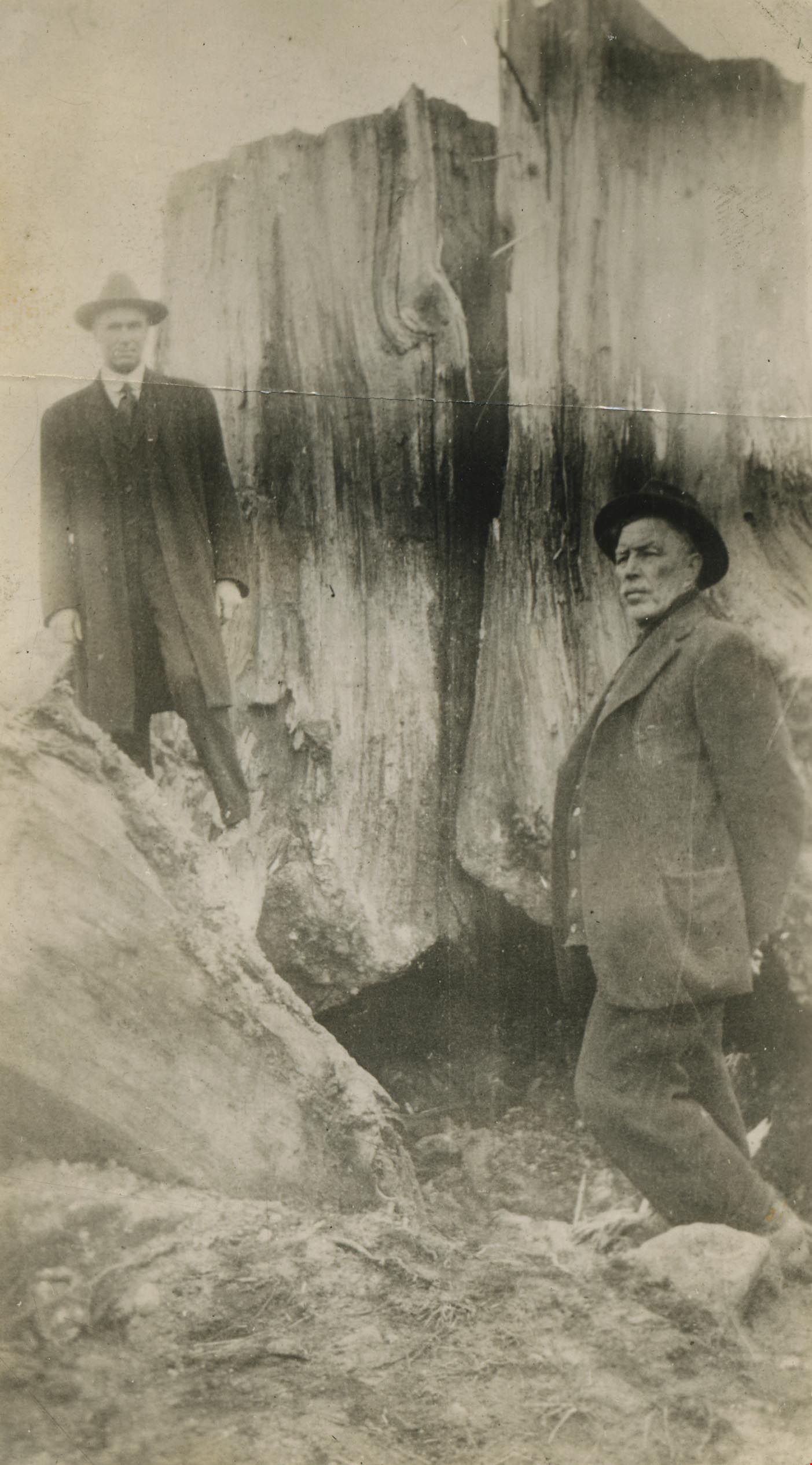
Mr. Tough and G.L. Lawson beside a tree stump
https://search.heritageburnaby.ca/link/archivedescription38544
- Repository
- City of Burnaby Archives
- Date
- 1921
- Collection/Fonds
- Burnaby Historical Society fonds
- Description Level
- Item
- Physical Description
- 1 photograph : b&w ; 6 x 10.8 cm
- Scope and Content
- Photograph of two men standing next to a large tree stump. A note written on the back of the photograph reads: " Stump blasted out by William Tough, street sup't [sic] in 1921. It stood on the boulevard on the south side of Hastings Street a few feet East of Ingleton. At left Councillor G. L. La…
- Repository
- City of Burnaby Archives
- Date
- 1921
- Collection/Fonds
- Burnaby Historical Society fonds
- Subseries
- New Westminster Public Library subseries
- Physical Description
- 1 photograph : b&w ; 6 x 10.8 cm
- Description Level
- Item
- Record No.
- 459-004
- Access Restriction
- No restrictions
- Reproduction Restriction
- No known restrictions
- Accession Number
- BHS2003-19
- Scope and Content
- Photograph of two men standing next to a large tree stump. A note written on the back of the photograph reads: " Stump blasted out by William Tough, street sup't [sic] in 1921. It stood on the boulevard on the south side of Hastings Street a few feet East of Ingleton. At left Councillor G. L. Lawson. Right, Mr. Tough." Councillor Lawson served on council from 1919-1920 and again from 1922-1923.
- Media Type
- Photograph
- Notes
- Title based on caption
- Geographic Access
- Hastings Street
- Ingleton Avenue
- Street Address
- 3900 Hastings Street
- Historic Neighbourhood
- Vancouver Heights (Historic Neighbourhood)
- Planning Study Area
- Willingdon Heights Area
Images