Narrow Results By
Subject
- Advertising Medium - Signs and Signboards 2
- Arts - Sculptures 1
- Building Components
- Buildings - Residential 1
- Buildings - Residential - Apartments 1
- Ceremonies - Awards 1
- Corporations - Private Corporations 1
- Documentary Artifacts - Architectural Drawings 1
- Documentary Artifacts - Maps
- Geographic Features - Roads 1
- Government - Local Government 1
- Industries 1
![Margaret Manifold and the Community Asset Mapping System, [2005] thumbnail](/media/hpo/_Data/_Archives_Images/_Unrestricted/535/535-1927-1.jpg?width=280)
Margaret Manifold and the Community Asset Mapping System
https://search.heritageburnaby.ca/link/archivedescription96243
- Repository
- City of Burnaby Archives
- Date
- [2005]
- Collection/Fonds
- Burnaby NewsLeader photograph collection
- Description Level
- File
- Physical Description
- 2 photographs (tiff) : col.
- Scope and Content
- File contains photographs of Margaret Manifold, of the City of Burnaby Planning Department, posing with print-outs of maps that will form the online Community Asset Mapping System. A large aerial photograph of Burnaby and the Lower Mainland is on the wall behind Manifold.
- Repository
- City of Burnaby Archives
- Date
- [2005]
- Collection/Fonds
- Burnaby NewsLeader photograph collection
- Physical Description
- 2 photographs (tiff) : col.
- Description Level
- File
- Record No.
- 535-1927
- Access Restriction
- No restrictions
- Reproduction Restriction
- No restrictions
- Accession Number
- 2018-12
- Scope and Content
- File contains photographs of Margaret Manifold, of the City of Burnaby Planning Department, posing with print-outs of maps that will form the online Community Asset Mapping System. A large aerial photograph of Burnaby and the Lower Mainland is on the wall behind Manifold.
- Media Type
- Photograph
- Photographer
- Medig, Kari
- Notes
- Title based on caption
- Collected by editorial for use in a February 2005 issue of the Burnaby NewsLeader
- Caption from metadata: "Margaret Manifold of the City of Burnaby's planning department poses with some hard copies of the online Community Assett Mapping System, which will soon be on the city's website."
Images
![Margaret Manifold and the Community Asset Mapping System, [2005] thumbnail](/media/hpo/_Data/_Archives_Images/_Unrestricted/535/535-1927-1.jpg)
![SFU Geography class with maps, [2000] thumbnail](/media/hpo/_Data/_Archives_Images/_Unrestricted/535/535-2626.jpg?width=280)
SFU Geography class with maps
https://search.heritageburnaby.ca/link/archivedescription97099
- Repository
- City of Burnaby Archives
- Date
- [2000]
- Collection/Fonds
- Burnaby NewsLeader photograph collection
- Description Level
- Item
- Physical Description
- 1 photograph (tiff) : col.
- Scope and Content
- Photograph of Mike Carr and Simon Fraser University Geography students Dallas Arcangel, Dave Crossley, Caoimhe Kehler and Peter Schaub with maps of "Salmonopolis." They are standing on the roof of an SFU building with forest and mountains visible in the background.
- Repository
- City of Burnaby Archives
- Date
- [2000]
- Collection/Fonds
- Burnaby NewsLeader photograph collection
- Physical Description
- 1 photograph (tiff) : col.
- Description Level
- Item
- Record No.
- 535-2626
- Access Restriction
- No restrictions
- Reproduction Restriction
- No restrictions
- Accession Number
- 2018-12
- Scope and Content
- Photograph of Mike Carr and Simon Fraser University Geography students Dallas Arcangel, Dave Crossley, Caoimhe Kehler and Peter Schaub with maps of "Salmonopolis." They are standing on the roof of an SFU building with forest and mountains visible in the background.
- Names
- Simon Fraser University
- Media Type
- Photograph
- Photographer
- Bartel, Mario
- Notes
- Title based on caption
- Collected by editorial for use in a July 2000 issue of the Burnaby NewsLeader
- Caption from metadata: "SFU geography instructor Mike Carr, and his team of students (front to back), Dallas Arcangel, Dave Crossley, Caoimhe Kehler and Peter Schaub, examine the maps of "Salmonopolis" they've created as part of a plan to create a sustainable region."
- Geographic Access
- Burnaby Mountain Conservation Area
- University Drive
- Street Address
- 8888 University Drive
- Planning Study Area
- Burnaby Mountain Area
Images
![SFU Geography class with maps, [2000] thumbnail](/media/hpo/_Data/_Archives_Images/_Unrestricted/535/535-2626.jpg)
Trophy
https://search.heritageburnaby.ca/link/museumartifact90819
- Repository
- Burnaby Village Museum
- Accession Code
- BV020.40.10
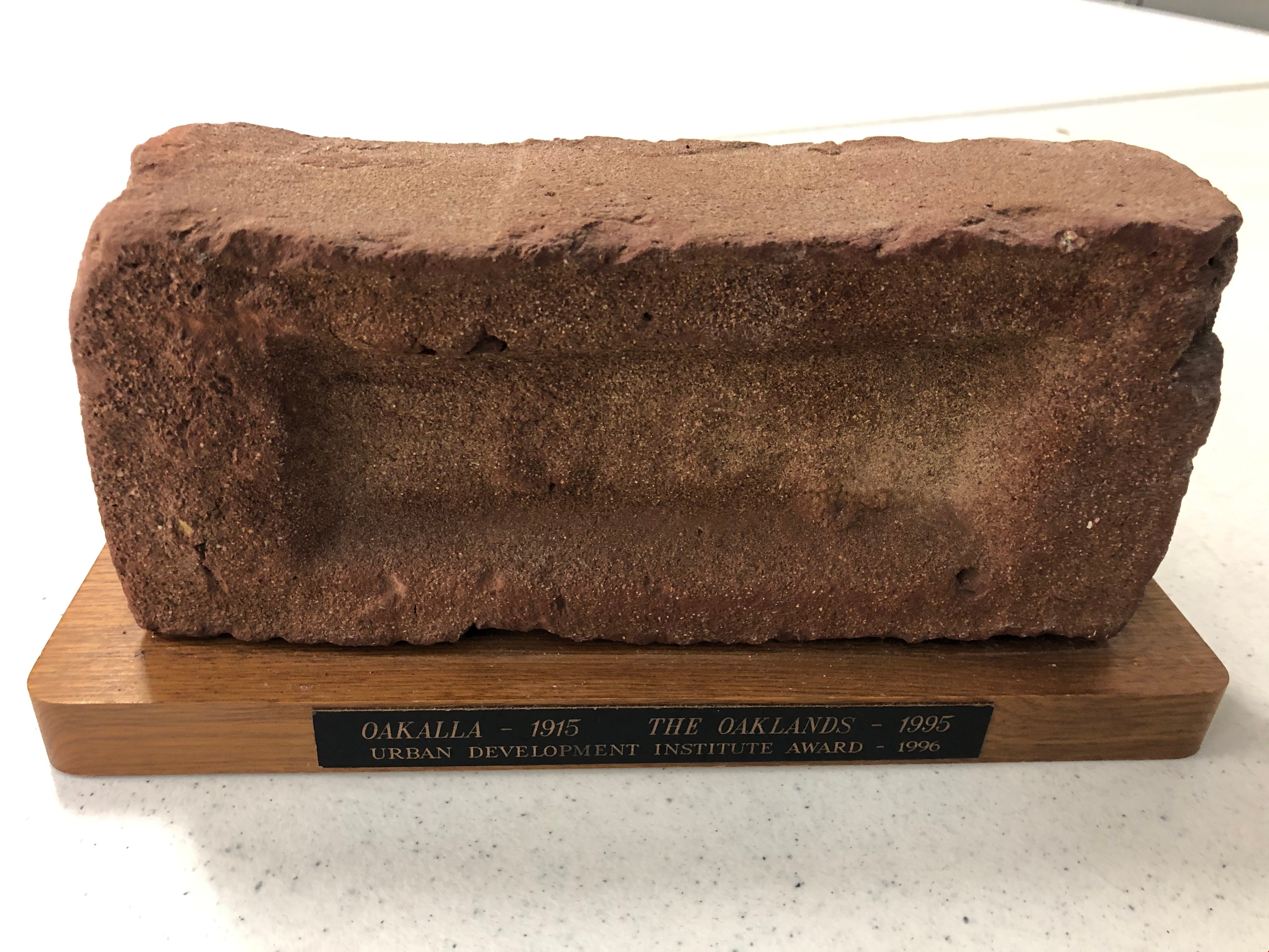
- Description
- Maroon brick mounted to a brown varnished wooden stand. On one long edge of the wooden stand is a black plaque with gold letteres reads: OAKALLA 1915 / THE OAKLANDS / Urban Development Institute Award - 1996
- Object History
- This was awarded to the City of Burnaby Planning Department by the Urban Development Institute in 1996 for the redevlopment of the lands which were Oakalla Provincial Prison from 1915-1991.
- Category
- 08. Communication Artifacts
- Classification
- Personal Symbols - - Achievement Symbols
- Object Term
- Trophy
- Colour
- Maroon
- Brown
- Subjects
- Building Components
- Ceremonies - Awards
- Planning - City Planning
- Public Services - Correctional
- Names
- Oakalla Prison Farm
- Historic Neighbourhood
- Central Park (Historic Neighbourhood)
- Planning Study Area
- Oakalla Area
Images