Narrow Results By
Subject
- Advertising Medium - Signs and Signboards 2
- Arts - Sculptures 1
- Building Components 1
- Buildings - Residential 1
- Buildings - Residential - Apartments 1
- Ceremonies - Awards 1
- Corporations - Private Corporations 1
- Documentary Artifacts - Architectural Drawings 1
- Documentary Artifacts - Maps 2
- Geographic Features - Roads 1
- Government - Local Government 1
- Industries 1
A development programme for Burnaby Lake Regional Park
https://search.heritageburnaby.ca/link/museumlibrary5165
- Repository
- Burnaby Village Museum
- Author
- Burnaby Planning Department
- Publication Date
- 1975
- Call Number
- 333.78 BUR copy 1
- Repository
- Burnaby Village Museum
- Collection
- Reference Collection
- Material Type
- Book
- Call Number
- 333.78 BUR copy 1
- Author
- Burnaby Planning Department
- Place of Publication
- Burnaby, B.C.
- Publisher
- Planning Dept.
- Publication Date
- 1975
- Physical Description
- 63, xi p. : ill. ; 22 x 35 cm
- Library Subject (LOC)
- Parks--British Columbia--Burnaby
- City planning--British Columbia--Burnaby
- Burnaby Lake Regional Park (B.C.)
- Subjects
- Planning - City Planning
- Notes
- Includes bibliographical references.
- 2 copies held ; copy 1

Burnaby Heights "panhandling meter"
https://search.heritageburnaby.ca/link/archivedescription97994
- Repository
- City of Burnaby Archives
- Date
- [2000]
- Collection/Fonds
- Burnaby NewsLeader photograph collection
- Description Level
- File
- Physical Description
- 2 photographs (tiff) : col.
- Scope and Content
- File contains photographs of Mark, a panhandler, on Hastings Street by a "panhandling meter" installed by the City of Burnaby. The meter reads: "This is not a parking meter / Spare change for social change."
- Repository
- City of Burnaby Archives
- Date
- [2000]
- Collection/Fonds
- Burnaby NewsLeader photograph collection
- Physical Description
- 2 photographs (tiff) : col.
- Description Level
- File
- Record No.
- 535-3098
- Access Restriction
- No restrictions
- Reproduction Restriction
- No restrictions
- Accession Number
- 2018-12
- Scope and Content
- File contains photographs of Mark, a panhandler, on Hastings Street by a "panhandling meter" installed by the City of Burnaby. The meter reads: "This is not a parking meter / Spare change for social change."
- Media Type
- Photograph
- Photographer
- Bartel, Mario
- Notes
- Title based on caption
- Collected by editorial for use in a February 2000 issue of the Burnaby NewsLeader
- Caption from metadata for 535-3098-1: "Mark says he panhandles along Hastings St. when he's hungry and can't afford food. He says the new meters haven't affected his take."
- Caption from metadata for 535-3098-2: "The new spare change meters haven't disuaded panhandlers, like Mark, from setting up shop along Hastings St. He says he panhandles when he needs money for food."
- Geographic Access
- Hastings Street
- Carleton Avenue
- Historic Neighbourhood
- Vancouver Heights (Historic Neighbourhood)
- Planning Study Area
- Burnaby Heights Area
Images

Burnaby Metrotown : a development plan
https://search.heritageburnaby.ca/link/museumlibrary4951
- Repository
- Burnaby Village Museum
- Collection
- Special Collection
- Material Type
- Book
- Accession Code
- BV006.24.38
- Call Number
- 307.1 BUR
- Place of Publication
- [Burnaby, B.C.]
- Publisher
- Burnaby Planning Dept.
- Publication Date
- 1977
- Printer
- College Printers Ltd.
- Physical Description
- 83 p. : ill. : 22 x 28 cm.
- Inscription
- "Page 67 Land purchase" [Handwritten in blue ink on page 3]
- Library Subject (LOC)
- City planning--British Columbia
- City planning--British Columbia--Burnaby
- Central business districts--British Columbia--Vancouver Region
- Vancouver (B.C.)--Suburbs and environs
- Burnaby, B.C.
- Metrotown (Burnaby, B.C.)
- Community development, Urban
- Central business districts
- Subjects
- Planning - City Planning
Burnaby Metrotown : a project
https://search.heritageburnaby.ca/link/museumlibrary1156
- Repository
- Burnaby Village Museum
- Author
- Daon Development Corporation
- Publication Date
- 1984
- Call Number
- 971.1 MET
- Repository
- Burnaby Village Museum
- Collection
- Reference Collection
- Material Type
- Textual Record
- Call Number
- 971.1 MET
- Author
- Daon Development Corporation
- Place of Publication
- [S.l.]
- Publisher
- Daon Development Corporation
- Publication Date
- 1984
- Physical Description
- 1 v. (no paging) : ill. (some col.) ; 30 cm.
- Inscription
- "Colin - museum director / For you to do with as you wish - / discard or retain for historical reasons. / J. Plesha / Aug 1990", handwritten in pencil and ink on a note inserted in the pocket on the inside of the front cover.
- Library Subject (LOC)
- City planning--British Columbia--Burnaby
- Community development, Urban
- Central business districts--British Columbia--Vancouver Region
- Subjects
- Planning - City Planning
![Burnaby Mountain community consultation, [2000] thumbnail](/media/hpo/_Data/_Archives_Images/_Unrestricted/535/535-2539.jpg?width=280)
Burnaby Mountain community consultation
https://search.heritageburnaby.ca/link/archivedescription97007
- Repository
- City of Burnaby Archives
- Date
- [2000]
- Collection/Fonds
- Burnaby NewsLeader photograph collection
- Description Level
- Item
- Physical Description
- 1 photograph (tiff) : col.
- Scope and Content
- Photograph of Burnaby resident John Unger filing out a comment form at a open house and community consultation event about development plans for Burnaby Mountain, held at the Copeland Arena. Posters outlining the development plans are visible behind Unger.
- Repository
- City of Burnaby Archives
- Date
- [2000]
- Collection/Fonds
- Burnaby NewsLeader photograph collection
- Physical Description
- 1 photograph (tiff) : col.
- Description Level
- Item
- Record No.
- 535-2539
- Access Restriction
- No restrictions
- Reproduction Restriction
- No restrictions
- Accession Number
- 2018-12
- Scope and Content
- Photograph of Burnaby resident John Unger filing out a comment form at a open house and community consultation event about development plans for Burnaby Mountain, held at the Copeland Arena. Posters outlining the development plans are visible behind Unger.
- Media Type
- Photograph
- Photographer
- Bartel, Mario
- Notes
- Title based on caption
- Collected by editorial for use in a July 2000 issue of the Burnaby NewsLeader
- Caption from metadata: "Burnaby residents, like John Unger, take the opportunity to fill out comment forms at an open house at Copeland Arena to unveil development plans for Burnaby Mountain."
- Geographic Access
- Burnaby Lake Sports Complex
- Kensington Avenue
- Street Address
- 3676 Kensington Avenue
- Historic Neighbourhood
- Burnaby Lake (Historic Neighbourhood)
- Planning Study Area
- Ardingley-Sprott Area
Images
![Burnaby Mountain community consultation, [2000] thumbnail](/media/hpo/_Data/_Archives_Images/_Unrestricted/535/535-2539.jpg)
Burnaby tourism strategy
https://search.heritageburnaby.ca/link/museumlibrary7603
- Repository
- Burnaby Village Museum
- Collection
- Reference Collection
- Material Type
- Book
- Call Number
- 338.4791 BUR
- Place of Publication
- Burnaby, BC
- Publisher
- City of Burnaby
- Publication Date
- 1994
- Physical Description
- 82 p. : ill. ; 29 cm.
- Library Subject (LOC)
- City planning--British Columbia--Burnaby
- Subjects
- Planning - City Planning
- Notes
- "Produced by the Burnaby Tourism Strategy Advisory Committee Membership outlined in Appendix C, Project manager, Phil Sanderson, Economic Development Office Economic Development Office, City of Burnaby. Consultants: James MacGregor (Lavalin Corp.) in collaboration with Addison Travel Marketing, G.S. Sue Henderson & Associates."
Burnaby trail study
https://search.heritageburnaby.ca/link/museumlibrary5479
- Repository
- Burnaby Village Museum
- Collection
- Reference Collection
- Material Type
- Book
- Call Number
- 711.558 BUR
- Place of Publication
- Burnaby
- Publisher
- Planning Dept.
- Publication Date
- 1980
- Physical Description
- 105 p. : ill. ; 36 cm.
- Library Subject (LOC)
- City planning--British Columbia
- Trails--British Columbia--Burnaby
- City planning--British Columbia--Burnaby
- Parks--British Columbia--Burnaby
- Subjects
- Planning - City Planning
- Notes
- Document inserted in cover: "Re: access, trail development Burnaby foreshore areas, acting municipal manager's recommendation", July 06, 1988, Item 29, Manager's report no. 47, council meeting: 1988/07/11.
- Oversized book.
The Burnaby transportation plan
https://search.heritageburnaby.ca/link/museumlibrary1237
- Repository
- Burnaby Village Museum
- Collection
- Reference Collection
- Material Type
- Textual Record
- Call Number
- 711.7 BUR
- Place of Publication
- Burnaby
- Publisher
- City of Burnaby
- Publication Date
- 1995
- Physical Description
- 132 [178] p.: ill. ; 30 cm.
- Library Subject (LOC)
- Urban Transportation--British Columbia--Burnaby
- City planning--British Columbia--Burnaby
- Subjects
- Planning - City Planning
![Caila Anderson with traffic signs, [2000] thumbnail](/media/hpo/_Data/_Archives_Images/_Unrestricted/535/535-2547.jpg?width=280)
Caila Anderson with traffic signs
https://search.heritageburnaby.ca/link/archivedescription97015
- Repository
- City of Burnaby Archives
- Date
- [2000]
- Collection/Fonds
- Burnaby NewsLeader photograph collection
- Description Level
- Item
- Physical Description
- 1 photograph (tiff) : col.
- Scope and Content
- Photograph of Caila Anderson, an employee of International SPFX, standing with her arms crossed next to two traffic signs on Greenwood Street.
- Repository
- City of Burnaby Archives
- Date
- [2000]
- Collection/Fonds
- Burnaby NewsLeader photograph collection
- Physical Description
- 1 photograph (tiff) : col.
- Description Level
- Item
- Record No.
- 535-2547
- Access Restriction
- No restrictions
- Reproduction Restriction
- No restrictions
- Accession Number
- 2018-12
- Scope and Content
- Photograph of Caila Anderson, an employee of International SPFX, standing with her arms crossed next to two traffic signs on Greenwood Street.
- Subjects
- Planning - City Planning
- Advertising Medium - Signs and Signboards
- Geographic Features - Roads
- Media Type
- Photograph
- Photographer
- Bartel, Mario
- Notes
- Title based on caption
- Collected by editorial for use in a July 2000 issue of the Burnaby NewsLeader
- Caption from metadata: "Caila Anderson, of International SPFX, says new traffic regulations on Greenwood St. have made it really inconvenient for employees at the movie special effects company to get to and from their production offices. Residents on the street say the regulations haven't gone far enough."
- Geographic Access
- Greenwood Street
- Historic Neighbourhood
- Lozells (Historic Neighbourhood)
- Planning Study Area
- Government Road Area
Images
![Caila Anderson with traffic signs, [2000] thumbnail](/media/hpo/_Data/_Archives_Images/_Unrestricted/535/535-2547.jpg)
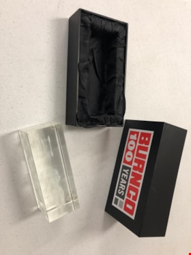
Glass Sculpture
https://search.heritageburnaby.ca/link/museumartifact90817
- Repository
- Burnaby Village Museum
- Accession Code
- BV020.40.8
- Description
- Glass rectangular prism with 3D etching depicting heavy duty trucks. Each corner of the bottom of the sculpture has a small pad. The sculpture has a branded black box for safe carrying. The box is in two parts. The exterior of both parts is covered in a black vinyl wrap, and polyester satin in the inside. The inside of each box is inset to fit on half of the sculpture. The top half of the box has a "Burnco 100 Years" logo in red, gray, white and black.
- Object History
- The Burnco company was established in Calgary in 1912 as a rock and aggregate and concrete supply company. This presentation piece was presented to the City of Burnaby on the establishment of its new Burnaby based plant in the Big Bend area in 2004.
- Category
- 08. Communication Artifacts
- Classification
- Ceremonial Artifacts
- Object Term
- Sculpture
- Marks/Labels
- BURNCO 100 YEARS
- Colour
- Red
- Gray
- White
- Black
- Subjects
- Arts - Sculptures
- Corporations - Private Corporations
- Industries
- Natural Resources - Mineral Resources
- Planning - City Planning
- Historic Neighbourhood
- Fraser Arm (Historic Neighbourhood)
- Planning Study Area
- Big Bend Area
Images


Ink
https://search.heritageburnaby.ca/link/museumartifact90812
- Repository
- Burnaby Village Museum
- Accession Code
- BV020.40.3
- Description
- Glass bottle of black ink, with a plastic textured lid. The front label is yellow with a gold border, and a blue band along the bottom of the label. It has a black ink stain down the front. The back label is smaller and lighter colour with a yellow stain that reaches to the middle of the label.
- Object History
- This ink came along with a lettering guide used in the City of Burnaby's Planning Department, in the late 1950s. See also BV020.40.2
- Classification
- Written Communication T&E - - Writing Accessories
- Object Term
- Ink
- Marks/Labels
- Chin-Chin waterproof Liquid PearlInk / Sole Canadian Distributors / Made in Germany / Protect from Freezing
- Colour
- Black
- Yellow
- Blue
- Measurements
- 30cm high
- Maker
- PearlInk
- Subjects
- Documentary Artifacts - Architectural Drawings
- Government - Local Government
- Land - Land Surveying
- Occupations - Civic Workers
- Planning - City Planning
- Historic Neighbourhood
- Burnaby Lake (Historic Neighbourhood)
- Planning Study Area
- Douglas-Gilpin Area
Images

The livable region 1976/1986 : proposals to manage the growth of Greater Vancouver
https://search.heritageburnaby.ca/link/museumlibrary5156
- Repository
- Burnaby Village Museum
- Collection
- Reference Collection
- Material Type
- Book
- Call Number
- 710.09 LIV COPY 1
- Place of Publication
- Vancouver
- Publisher
- Greater Vancouver Regional District
- Publication Date
- 1975
- Physical Description
- 50 p. : ill., maps ; 22 x 30 cm.
- Library Subject (LOC)
- City planning--British Columbia--Vancouver Metropolitan Area
- Regional planning--British Columbia--Vancouver Metropolitan Area
- Subjects
- Planning - City Planning
- Notes
- 3 copies held, copy 1.
![Margaret Manifold and the Community Asset Mapping System, [2005] thumbnail](/media/hpo/_Data/_Archives_Images/_Unrestricted/535/535-1927-1.jpg?width=280)
Margaret Manifold and the Community Asset Mapping System
https://search.heritageburnaby.ca/link/archivedescription96243
- Repository
- City of Burnaby Archives
- Date
- [2005]
- Collection/Fonds
- Burnaby NewsLeader photograph collection
- Description Level
- File
- Physical Description
- 2 photographs (tiff) : col.
- Scope and Content
- File contains photographs of Margaret Manifold, of the City of Burnaby Planning Department, posing with print-outs of maps that will form the online Community Asset Mapping System. A large aerial photograph of Burnaby and the Lower Mainland is on the wall behind Manifold.
- Repository
- City of Burnaby Archives
- Date
- [2005]
- Collection/Fonds
- Burnaby NewsLeader photograph collection
- Physical Description
- 2 photographs (tiff) : col.
- Description Level
- File
- Record No.
- 535-1927
- Access Restriction
- No restrictions
- Reproduction Restriction
- No restrictions
- Accession Number
- 2018-12
- Scope and Content
- File contains photographs of Margaret Manifold, of the City of Burnaby Planning Department, posing with print-outs of maps that will form the online Community Asset Mapping System. A large aerial photograph of Burnaby and the Lower Mainland is on the wall behind Manifold.
- Media Type
- Photograph
- Photographer
- Medig, Kari
- Notes
- Title based on caption
- Collected by editorial for use in a February 2005 issue of the Burnaby NewsLeader
- Caption from metadata: "Margaret Manifold of the City of Burnaby's planning department poses with some hard copies of the online Community Assett Mapping System, which will soon be on the city's website."
Images
![Margaret Manifold and the Community Asset Mapping System, [2005] thumbnail](/media/hpo/_Data/_Archives_Images/_Unrestricted/535/535-1927-1.jpg)
![SFU Geography class with maps, [2000] thumbnail](/media/hpo/_Data/_Archives_Images/_Unrestricted/535/535-2626.jpg?width=280)
SFU Geography class with maps
https://search.heritageburnaby.ca/link/archivedescription97099
- Repository
- City of Burnaby Archives
- Date
- [2000]
- Collection/Fonds
- Burnaby NewsLeader photograph collection
- Description Level
- Item
- Physical Description
- 1 photograph (tiff) : col.
- Scope and Content
- Photograph of Mike Carr and Simon Fraser University Geography students Dallas Arcangel, Dave Crossley, Caoimhe Kehler and Peter Schaub with maps of "Salmonopolis." They are standing on the roof of an SFU building with forest and mountains visible in the background.
- Repository
- City of Burnaby Archives
- Date
- [2000]
- Collection/Fonds
- Burnaby NewsLeader photograph collection
- Physical Description
- 1 photograph (tiff) : col.
- Description Level
- Item
- Record No.
- 535-2626
- Access Restriction
- No restrictions
- Reproduction Restriction
- No restrictions
- Accession Number
- 2018-12
- Scope and Content
- Photograph of Mike Carr and Simon Fraser University Geography students Dallas Arcangel, Dave Crossley, Caoimhe Kehler and Peter Schaub with maps of "Salmonopolis." They are standing on the roof of an SFU building with forest and mountains visible in the background.
- Names
- Simon Fraser University
- Media Type
- Photograph
- Photographer
- Bartel, Mario
- Notes
- Title based on caption
- Collected by editorial for use in a July 2000 issue of the Burnaby NewsLeader
- Caption from metadata: "SFU geography instructor Mike Carr, and his team of students (front to back), Dallas Arcangel, Dave Crossley, Caoimhe Kehler and Peter Schaub, examine the maps of "Salmonopolis" they've created as part of a plan to create a sustainable region."
- Geographic Access
- Burnaby Mountain Conservation Area
- University Drive
- Street Address
- 8888 University Drive
- Planning Study Area
- Burnaby Mountain Area
Images
![SFU Geography class with maps, [2000] thumbnail](/media/hpo/_Data/_Archives_Images/_Unrestricted/535/535-2626.jpg)
![SkyTrain consultation, [1999] thumbnail](/media/hpo/_Data/_Archives_Images/_Unrestricted/535/535-3127.jpg?width=280)
SkyTrain consultation
https://search.heritageburnaby.ca/link/archivedescription98047
- Repository
- City of Burnaby Archives
- Date
- [1999]
- Collection/Fonds
- Burnaby NewsLeader photograph collection
- Description Level
- Item
- Physical Description
- 1 photograph (tiff) : col.
- Scope and Content
- Photograph of two unidentified people at a public consultation. They are viewing maps and aerial photographs related to the SkyTrain line.
- Repository
- City of Burnaby Archives
- Date
- [1999]
- Collection/Fonds
- Burnaby NewsLeader photograph collection
- Physical Description
- 1 photograph (tiff) : col.
- Description Level
- Item
- Record No.
- 535-3127
- Access Restriction
- No restrictions
- Reproduction Restriction
- No restrictions
- Accession Number
- 2018-12
- Scope and Content
- Photograph of two unidentified people at a public consultation. They are viewing maps and aerial photographs related to the SkyTrain line.
- Media Type
- Photograph
- Notes
- Title based on contents of photograph
- Collected by editorial for use in a February 1999 issue of the Burnaby NewsLeader
Images
![SkyTrain consultation, [1999] thumbnail](/media/hpo/_Data/_Archives_Images/_Unrestricted/535/535-3127.jpg)

Sussex Villa
https://search.heritageburnaby.ca/link/archivedescription98659
- Repository
- City of Burnaby Archives
- Date
- 2022
- Collection/Fonds
- Disappearing Burnaby collection
- Description Level
- Item
- Physical Description
- 1 photograph (jpeg) : col.
- Scope and Content
- Photograph of part of the exterior and front lawn of Sussex Villa, an apartment complex located at 6620-6630 Sussex Avenue, at night. The building was constructed in 1965 and is set to be developed into a high-rise tower by Keltic Canada Development. A light is on inside one of the apartment window…
- Repository
- City of Burnaby Archives
- Date
- 2022
- Collection/Fonds
- Disappearing Burnaby collection
- Physical Description
- 1 photograph (jpeg) : col.
- Description Level
- Item
- Record No.
- 634-006
- Access Restriction
- No restrictions
- Reproduction Restriction
- No restrictions
- Accession Number
- 2022-14
- Scope and Content
- Photograph of part of the exterior and front lawn of Sussex Villa, an apartment complex located at 6620-6630 Sussex Avenue, at night. The building was constructed in 1965 and is set to be developed into a high-rise tower by Keltic Canada Development. A light is on inside one of the apartment windows and a sign for the "Metrotown - Regional Town Centre Notification of Area Plan" stands on the lawn.
- Subjects
- Buildings - Residential - Apartments
- Buildings - Residential
- Advertising Medium - Signs and Signboards
- Planning - City Planning
- Media Type
- Photograph
- Photographer
- Cheung, Nakita
- Notes
- Title taken from the associated blog post
- Associated blog post: https://disappearingburnaby.wordpress.com/2022/01/29/sussex-villa-2/
- Geographic Access
- Sussex Avenue
- Street Address
- 6620 Sussex Avenue
- 6630 Sussex Avenue
- Historic Neighbourhood
- Central Park (Historic Neighbourhood)
- Planning Study Area
- Maywood Area
Images

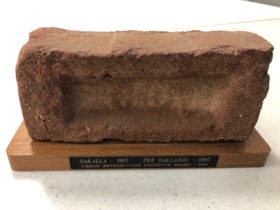
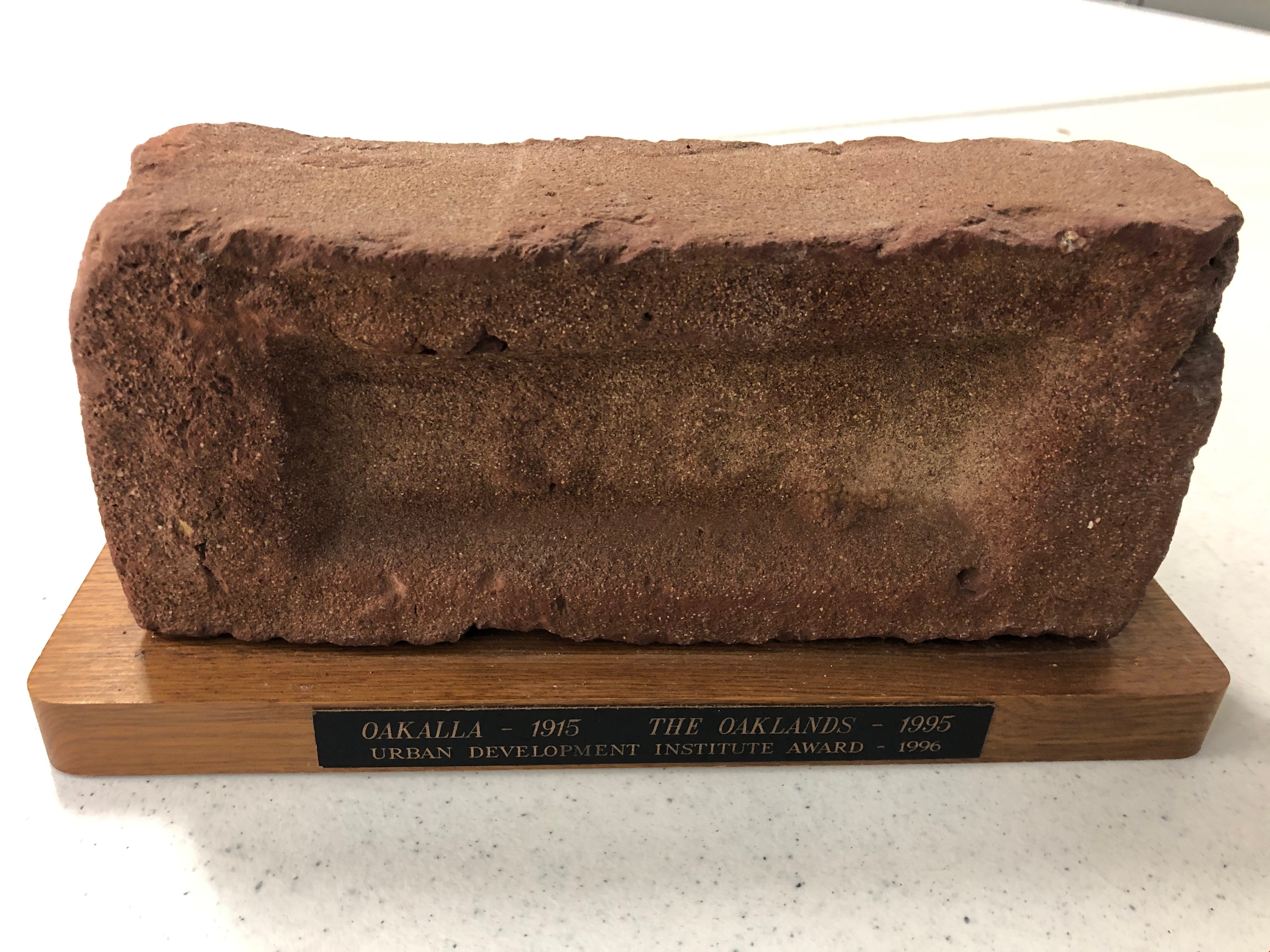
Trophy
https://search.heritageburnaby.ca/link/museumartifact90819
- Repository
- Burnaby Village Museum
- Accession Code
- BV020.40.10
- Description
- Maroon brick mounted to a brown varnished wooden stand. On one long edge of the wooden stand is a black plaque with gold letteres reads: OAKALLA 1915 / THE OAKLANDS / Urban Development Institute Award - 1996
- Object History
- This was awarded to the City of Burnaby Planning Department by the Urban Development Institute in 1996 for the redevlopment of the lands which were Oakalla Provincial Prison from 1915-1991.
- Category
- 08. Communication Artifacts
- Classification
- Personal Symbols - - Achievement Symbols
- Object Term
- Trophy
- Colour
- Maroon
- Brown
- Subjects
- Building Components
- Ceremonies - Awards
- Planning - City Planning
- Public Services - Correctional
- Names
- Oakalla Prison Farm
- Historic Neighbourhood
- Central Park (Historic Neighbourhood)
- Planning Study Area
- Oakalla Area
Images
Urban structure : a study of long range policies which affect the physical structure of an urban area
https://search.heritageburnaby.ca/link/museumlibrary3813
- Repository
- Burnaby Village Museum
- Author
- Sixta, Gerhard
- Publication Date
- c1971
- Call Number
- 309.2620971133 SIX
- Repository
- Burnaby Village Museum
- Collection
- Special Collection
- Material Type
- Book
- Accession Code
- BV003.51.1
- Call Number
- 309.2620971133 SIX
- Author
- Sixta, Gerhard
- Place of Publication
- Burnaby, B.C.
- Publisher
- Planning Dept. of the District of Burnaby, B.C.
- Publication Date
- c1971
- Physical Description
- 144 p. : ill. (some col.), maps ; 31 cm.
- Library Subject (LOC)
- City planning
- Social policy
- British Columbia--Vancouver
- Subjects
- Planning - City Planning
- Notes
- Illustrated by Gerhard Sixta.
- Includes bibliographical references and index.