Narrow Results By
Burnaby May Day
https://search.heritageburnaby.ca/link/archivedescription35326
- Repository
- City of Burnaby Archives
- Date
- May 26, 1928
- Collection/Fonds
- Burnaby Historical Society fonds
- Description Level
- Item
- Physical Description
- 1 photograph : b&w ; 12.7 x 17.8 cm print
- Scope and Content
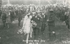
- Photograph of 1928 May Queen, Sylvia Murley (foreground, left) with Reeve Thomas Sanderson (foreground, centre) and Scoutmaster Tom Corbett (foreground, right) at Robert Burnaby Park. Sylvia Murley became Sylvia Auvache when she married Lewis Auvache, who would be Burnaby's Fire Chief between 1964…
- Repository
- City of Burnaby Archives
- Date
- May 26, 1928
- Collection/Fonds
- Burnaby Historical Society fonds
- Subseries
- Pioneer Tales subseries
- Physical Description
- 1 photograph : b&w ; 12.7 x 17.8 cm print
- Description Level
- Item
- Record No.
- 204-183
- Access Restriction
- No restrictions
- Reproduction Restriction
- No known restrictions
- Accession Number
- BHS1988-03
- Scope and Content
- Photograph of 1928 May Queen, Sylvia Murley (foreground, left) with Reeve Thomas Sanderson (foreground, centre) and Scoutmaster Tom Corbett (foreground, right) at Robert Burnaby Park. Sylvia Murley became Sylvia Auvache when she married Lewis Auvache, who would be Burnaby's Fire Chief between 1964 and 1972.
- Media Type
- Photograph
- Photographer
- Lloyd's Studio
- Notes
- Title based on caption on photograph
- Geographic Access
- Robert Burnaby Park
- Wedgewood Street
- Street Address
- 8155 Wedgewood Street
- Historic Neighbourhood
- Burnaby Lake (Historic Neighbourhood)
- Planning Study Area
- Lakeview-Mayfield Area
Images


Inman Avenue School
https://search.heritageburnaby.ca/link/archivedescription35450
- Repository
- City of Burnaby Archives
- Date
- 1921 (date of original), copied 1986
- Collection/Fonds
- Burnaby Historical Society fonds
- Description Level
- Item
- Physical Description
- 1 photograph : b&w ; 12.7 x 17.8 cm print
- Scope and Content
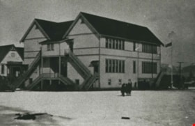
- Photograph of the exterior of Inman Avenue School at 3963 Brandon Street, near Kingsway.
- Repository
- City of Burnaby Archives
- Date
- 1921 (date of original), copied 1986
- Collection/Fonds
- Burnaby Historical Society fonds
- Subseries
- Pioneer Tales subseries
- Physical Description
- 1 photograph : b&w ; 12.7 x 17.8 cm print
- Description Level
- Item
- Record No.
- 204-308
- Access Restriction
- No restrictions
- Reproduction Restriction
- No restrictions
- Accession Number
- BHS1988-03
- Scope and Content
- Photograph of the exterior of Inman Avenue School at 3963 Brandon Street, near Kingsway.
- Subjects
- Buildings - Schools
- Names
- Inman Avenue School
- Media Type
- Photograph
- Photographer
- Eaton, Dr. Carl
- Notes
- Title based on contents of photograph
- Geographic Access
- Brandon Street
- Street Address
- 3963 Brandon Street
- Historic Neighbourhood
- Central Park (Historic Neighbourhood)
- Planning Study Area
- Garden Village Area
Images

Kingsway West School
https://search.heritageburnaby.ca/link/archivedescription35449
- Repository
- City of Burnaby Archives
- Date
- 1921 (date of original), copied 1986
- Collection/Fonds
- Burnaby Historical Society fonds
- Description Level
- Item
- Physical Description
- 1 photograph : b&w ; 12.7 x 17.8 cm print
- Scope and Content
- Photograph of the exterior of Kingsway West School (originally named West Burnaby School).
- Repository
- City of Burnaby Archives
- Date
- 1921 (date of original), copied 1986
- Collection/Fonds
- Burnaby Historical Society fonds
- Subseries
- Pioneer Tales subseries
- Physical Description
- 1 photograph : b&w ; 12.7 x 17.8 cm print
- Description Level
- Item
- Record No.
- 204-307
- Access Restriction
- No restrictions
- Reproduction Restriction
- No restrictions
- Accession Number
- BHS1988-03
- Scope and Content
- Photograph of the exterior of Kingsway West School (originally named West Burnaby School).
- Subjects
- Buildings - Schools
- Names
- Kingsway West School
- Media Type
- Photograph
- Photographer
- Eaton, Dr. Carl
- Notes
- Title based on contents of photograph
- Geographic Access
- Kingsway
- Street Address
- 4800 Kingsway
- Historic Neighbourhood
- Central Park (Historic Neighbourhood)
- Planning Study Area
- Maywood Area
Images

![Masonic Hall, [1920] (date of original), copied 1986 thumbnail](/media/hpo/_Data/_Archives_Images/_Unrestricted/204/204-289.jpg?width=280)
Masonic Hall
https://search.heritageburnaby.ca/link/archivedescription35431
- Repository
- City of Burnaby Archives
- Date
- [1920] (date of original), copied 1986
- Collection/Fonds
- Burnaby Historical Society fonds
- Description Level
- Item
- Physical Description
- 1 photograph : b&w ; 12.7 x 17.8 cm print
- Scope and Content
- Photograph of 4015 Triumph Street, Vancouver Heights Presbyterian Church at the corner of MacDonald Avenue and Triumph Street, with people playing tennis in the adjoining tennis court. The Hall's basement was used by overcrowded Gilmore School for classes and was also used for first Burnaby North h…
- Repository
- City of Burnaby Archives
- Date
- [1920] (date of original), copied 1986
- Collection/Fonds
- Burnaby Historical Society fonds
- Subseries
- Pioneer Tales subseries
- Physical Description
- 1 photograph : b&w ; 12.7 x 17.8 cm print
- Description Level
- Item
- Record No.
- 204-289
- Access Restriction
- No restrictions
- Reproduction Restriction
- No restrictions
- Accession Number
- BHS1988-03
- Scope and Content
- Photograph of 4015 Triumph Street, Vancouver Heights Presbyterian Church at the corner of MacDonald Avenue and Triumph Street, with people playing tennis in the adjoining tennis court. The Hall's basement was used by overcrowded Gilmore School for classes and was also used for first Burnaby North high school classes before Burnaby North High School was built. It later became the Zenith Masonic Hall.
- Names
- Burnaby North High School
- Gilmore Avenue School
- Masonic Hall
- Vancouver Heights Presbyterian Church
- Media Type
- Photograph
- Photographer
- Eaton, Dr. Carl
- Notes
- Title based on contents of photograph
- Geographic Access
- Triumph Street
- Street Address
- 4015 Triumph Street
- Historic Neighbourhood
- Vancouver Heights (Historic Neighbourhood)
- Planning Study Area
- Burnaby Heights Area
Images
![Masonic Hall, [1920] (date of original), copied 1986 thumbnail](/media/hpo/_Data/_Archives_Images/_Unrestricted/204/204-289.jpg)