Narrow Results By

309 Pine Street
https://search.heritageburnaby.ca/link/museumdescription2814
- Repository
- Burnaby Village Museum
- Date
- 1987
- Collection/Fonds
- Hawkshaw family fonds
- Description Level
- Item
- Physical Description
- 1 photograph : col. ; 10 x 12.5 cm
- Scope and Content
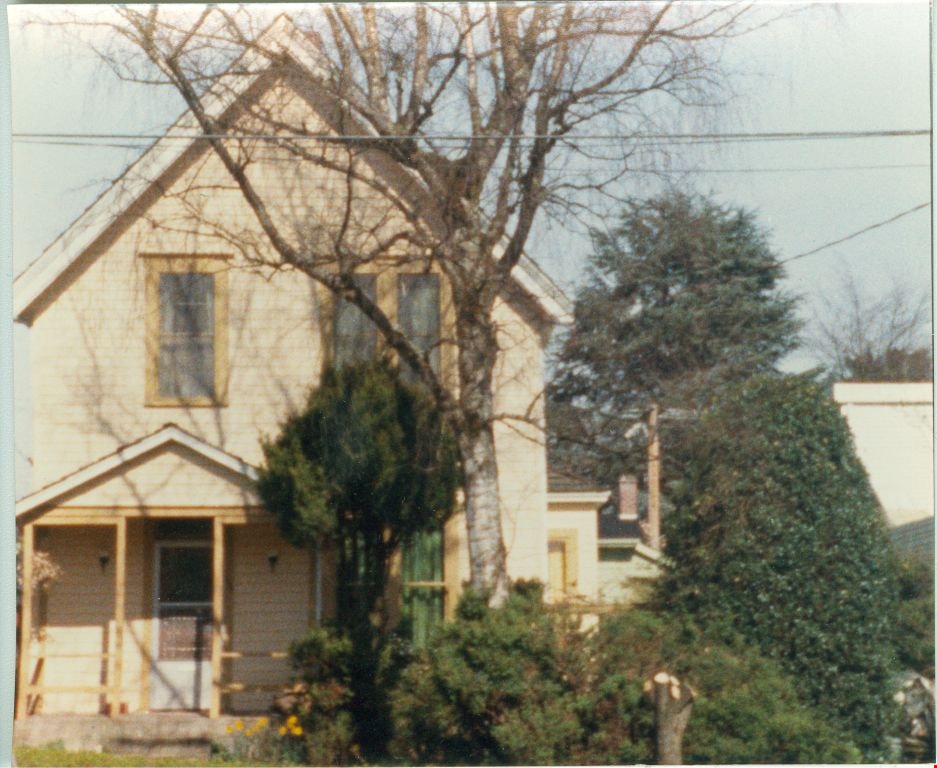
- Photograph of 309 Pine Street, New Westminster. This was John and Mabel Hawkshaw’s first home in 1910.
- Repository
- Burnaby Village Museum
- Collection/Fonds
- Hawkshaw family fonds
- Description Level
- Item
- Physical Description
- 1 photograph : col. ; 10 x 12.5 cm
- Scope and Content
- Photograph of 309 Pine Street, New Westminster. This was John and Mabel Hawkshaw’s first home in 1910.
- Subjects
- Buildings - Residential - Houses
- Geographic Access
- New Westminster
- Accession Code
- BV996.6.288
- Access Restriction
- No restrictions
- Reproduction Restriction
- No known restrictions
- Date
- 1987
- Media Type
- Photograph
- Scan Resolution
- 600
- Scan Date
- 2/24/2011
- Scale
- 100
- Notes
- Title based on contents of photograph
- Note on verso of photograph reads: "1987 / 309 Pine street / New Westminster / John + Mabel Hawkshaw's / 1st home / 1910"
Images
![Children in Sanders family backyard, [196-] thumbnail](/media/hpo/_Data/_BVM_Images/2018/2018_0034_0036_001.jpg?width=280)
Children in Sanders family backyard
https://search.heritageburnaby.ca/link/museumdescription9911
- Repository
- Burnaby Village Museum
- Date
- [196-]
- Collection/Fonds
- Gerald F. Sanders and Alice Sparman Sanders fonds
- Description Level
- Item
- Physical Description
- 1 photograph : b&w ; 8.7 cm x 12.8 cm
- Scope and Content
- Photograph of the Sanders children playing on a swing set in their back yard at 4325 Pine Street (address after 1959- 4091 Pine Street). Houses in background.
- Repository
- Burnaby Village Museum
- Collection/Fonds
- Gerald F. Sanders and Alice Sparman Sanders fonds
- Description Level
- Item
- Physical Description
- 1 photograph : b&w ; 8.7 cm x 12.8 cm
- Material Details
- Text in pencil on verso: "WHO NEEDS STANLEY PARK? / THE SANDERS BACK YARD / ANY SUNNY DAY"
- Scope and Content
- Photograph of the Sanders children playing on a swing set in their back yard at 4325 Pine Street (address after 1959- 4091 Pine Street). Houses in background.
- Names
- Sanders, Kris
- Sanders, Marie
- Sanders, Leslie
- Sanders, Reginald
- Sanders, Robin
- Sanders, Ruth
- Sanders, Kerry
- Geographic Access
- Pine Street
- Street Address
- 4091 Pine Street
- Accession Code
- BV018.34.36
- Date
- [196-]
- Media Type
- Photograph
- Historic Neighbourhood
- Broadview (Historic Neighbourhood)
- Planning Study Area
- Cascade-Schou Area
- Scan Resolution
- 600
- Scan Date
- 2022-07-12
- Notes
- Title based on contents of photograph
Images
![Children in Sanders family backyard, [196-] thumbnail](/media/hpo/_Data/_BVM_Images/2018/2018_0034_0036_001.jpg)
Sanders and Sparman families in yard
https://search.heritageburnaby.ca/link/museumdescription9912
- Repository
- Burnaby Village Museum
- Date
- 2 May 1971
- Collection/Fonds
- Gerald F. Sanders and Alice Sparman Sanders fonds
- Description Level
- Item
- Physical Description
- 1 photograph ;:col. ; 8.7 cm x 8.6 cm
- Scope and Content
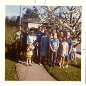
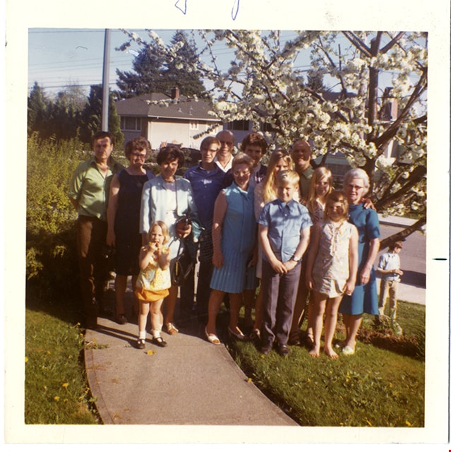
- Photograph of the Sanders and Sparman families standing under a blossoming cherry tree in the front yard of Gerald and Alice Sparman's home located at 4091 Pine Street.
- Repository
- Burnaby Village Museum
- Collection/Fonds
- Gerald F. Sanders and Alice Sparman Sanders fonds
- Description Level
- Item
- Physical Description
- 1 photograph ;:col. ; 8.7 cm x 8.6 cm
- Material Details
- Text in blue pen on verso: "Part of the gang Alice / had for dinner Sunday / May 2nd 1971 / Gerry + Alice - Eileen + husband - Lil - Eva / Les + children, Nana / and Marie Sanders."
- Scope and Content
- Photograph of the Sanders and Sparman families standing under a blossoming cherry tree in the front yard of Gerald and Alice Sparman's home located at 4091 Pine Street.
- Geographic Access
- Pine Street
- Street Address
- 4091 Pine Street
- Accession Code
- BV018.34.37
- Access Restriction
- No restrictions
- Reproduction Restriction
- No known restrictions
- Date
- 2 May 1971
- Media Type
- Photograph
- Historic Neighbourhood
- Broadview (Historic Neighbourhood)
- Planning Study Area
- Cascade-Schou Area
- Scan Resolution
- 600
- Scan Date
- 2022-07-12
- Notes
- Title based on contents of photograph
Images
![Survey and Subdivision plans in New Westminster District Group 1 & Group 2 - Burnaby, Port Moody, Coquitlam, Mission and Map of Port Simpson Harbour, [190-] thumbnail](/media/hpo/_Data/_BVM_Cartographic_Material/1977/1977_0093_0111_001.jpg?width=280)
Survey and Subdivision plans in New Westminster District Group 1 & Group 2 - Burnaby, Port Moody, Coquitlam, Mission and Map of Port Simpson Harbour
https://search.heritageburnaby.ca/link/museumdescription7080
- Repository
- Burnaby Village Museum
- Date
- [190-]
- Collection/Fonds
- Burnaby Village Museum Map collection
- Description Level
- File
- Physical Description
- 9 plans : 3 plans : blueprint ink on paper + 4 plans : black ink and graphite on linen + 2 plans : graphite on paper mounted on 2 sides of cardboard 76 x 102 cm
- Scope and Content
- File consists of a large board with five plans in New Westminster District, Group 1 mounted on one side and three plans in New Westminster District, Group 1 and a map of Port Simpson Harbour mounted on the other side. Side A: 1. Plan: blueprint on paper ; 30 x 20 cm. Title reads: "Plan of / Subdi…
- Repository
- Burnaby Village Museum
- Collection/Fonds
- Burnaby Village Museum Map collection
- Description Level
- File
- Physical Description
- 9 plans : 3 plans : blueprint ink on paper + 4 plans : black ink and graphite on linen + 2 plans : graphite on paper mounted on 2 sides of cardboard 76 x 102 cm
- Material Details
- Scales vary (One chain equals 792 inches)
- Indexed number on tape on edge of board reads "111"
- Scope and Content
- File consists of a large board with five plans in New Westminster District, Group 1 mounted on one side and three plans in New Westminster District, Group 1 and a map of Port Simpson Harbour mounted on the other side. Side A: 1. Plan: blueprint on paper ; 30 x 20 cm. Title reads: "Plan of / Subdivision of Part of D.L.172.GR.I.N.W.D." Scale: 200 feet = 1inch. dated, Feb.22, 1908, signed by land surveyor "Noel Humphreys" (Geographic location: District Lot 172, Burnaby) 2. Plan : graphite and blue crayon on paper ; 21.5 x 22 cm. Title in blue crayon reads: "N.E.1/4 & NW 1/4 Sec.25 / Tp 18". Scale: 10 chains=1 inch (Geographic location: Mission) 3. Plan : graphite on paper ; 31.5 x 16 cm. Title in blue crayon reads: "Lot 350_ Gr.1" with initials "RB". Scale : 3 chains = 1 inch. (Geographic location: Port Moody) 4. Plan ; graphite on linen ; 40 x 54 cm. Title in blue crayon reads: "Lot 190_Gr.1" with initials "RB". Plan covers area in Lot 190 including streets identified as; McInness Street, First Street, Second Street, Third Street, Fourth Street running through District Lot. (Geographic location: Port Moody) 5. Plan: blueprint on paper ; 50.5 x 57.5 cm. Title reads: "Plan of / T.F. Sinclair's Quarry Site. / SituateOnPittRiver.Sec.122T.P.40. / East of Coast Mer." Scale: 5 chains = 1inch. dated June 30 1908 [sic] Plan covers site of T.F. Sinclair's quarry in Section 22 of Township 40 on the shore of Pitt River. (Geographic location: Coquitlam ) Side B: 1. Map : blueprint on paper ; 50 x 38 cm. Scale: 40 chains - 1 inch. Title reads: "Map of Land on / Port Simpson Harbor". Scale : 40 chains = 1 inch Map covers subdivided land on the North Coast of British Columbia on the Tsimpsean Pennisula bordered by water identified as "Work Channel" to the west, "Port Simpson Harbour" to the east and land identified as "Indian Reserve" [Lax Kw'alaams] to the south. Names of property owners are identified in subdivided sections and area of land along the shore of "Work Channel" is identified as "Goverment Reserve". Blueprint includes inset "Key Map" with location of Port Simpson Harbour and Tsimpean Pennisula on the North Coast of British Columbia. 2. Plan : graphite on linen ; 24.5 x 46 cm. Title reads: "Portion of Lot 470 / Group 1" Scale : 2 chains = 1 inch. Plan covers a subdivided portion of District Lot 470, New Westminster District, Group 1 with streets identified as; "Pleasant Street", "Metta Street" and "Clarence Street". (Geographic location: Port Moody) 3. Plan : black ink on linen ; 40 x 30.5 cm. Title reads: "Plan / of / A Portion of the Foreshore / of / Lot 201 GR.2 / N.W.D. / Showing / Mill-Site". Scale : 100 feet = 1 inch. Plan is stamped in red ink: "Albert J. Hill, M.A., / Civil Engineer / And / Provincial Land Surveyor, / New Westminster, / B.C.". Survey notes in black ink read: "Surveyed Oct 9th 1908 for Messrs. / Roe & Abernathy and plan (duplicate / of this one) sent Oct. 8th / G.K. Burnett". (Geographic location : Port Moody) 4. Plan : black and red ink on line ; 63 x 29.5 cm. Title reads: "Port Moody / Butchard's Property". Scale : 200 feet = 1 inch. Plan covers subdivided lot into 16 parcels numbered I to XVI along the north shore of Burrard Inlet in Port Moody. Streets are identified as; George Street, Bruce Street, Norval Street, Nora Street, Elm Street, Pine Street, Orr Street and Orchard Street. Roads are identified as; West Road and East Road. (Geographic location : Port Moody)
- Creator
- Hill, Albert James
- Accession Code
- HV977.93.111
- Access Restriction
- No restrictions
- Reproduction Restriction
- No known restrictions
- Date
- [190-]
- Media Type
- Cartographic Material
- Scan Resolution
- 600
- Scan Date
- 2023-06-26
- Notes
- Title based on contents of file
Zoomable Images
![Survey and Subdivision plans in New Westminster District Group 1 & Group 2 - Burnaby, Port Moody, Coquitlam, Mission and Map of Port Simpson Harbour, [190-] thumbnail](/media/hpo/_Data/_BVM_Cartographic_Material/1977/1977_0093_0111_003_seadragon/1977_0093_0111_003.jpg?w=280)
Survey and Subdivision plans in New Westminster District Group 1 & Group 2 - Burnaby, Port Moody, Coquitlam, Mission and Map of Port Simpson Harbour, [190-]
Zoom into Image