Narrow Results By
Subject
- Adornment - Lapel Pins 1
- Advertising Medium 3
- Advertising Medium - Flyer 1
- Advertising Medium - Poster 1
- Advertising Medium - Signs and Signboards 6
- Agricultural Tools and Equipment 1
- Agriculture 1
- Agriculture - Farms 1
- Agriculture - Fruit and Berries 1
- Animals - Cats 1
- Animals - Dogs 7
- Animals - Horses 2
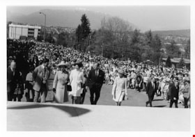
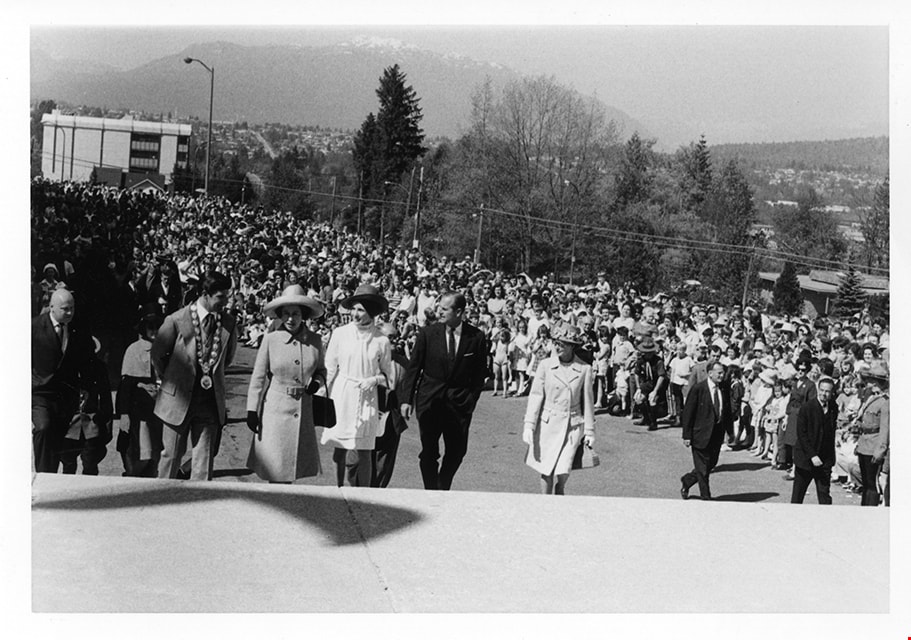
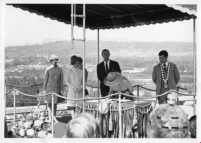
Queen Elizabeth II, Prince Philip and officials during Royal visit to Burnaby Municipal Hall
https://search.heritageburnaby.ca/link/museumdescription13161
- Repository
- Burnaby Village Museum
- Date
- 7 May 1971
- Collection/Fonds
- Donald Copan collection
- Description Level
- Item
- Physical Description
- 1 photograph : b&w ; 8.9 x 12.7 cm
- Scope and Content
- Photograph of Queen Elizabeth II, acting-mayor Hugh Ladner and his wife Valerie Ruth Ladner (dressed in white), Prince Philip and Mrs. James A. Barrington (wearing floral hat) climbing the stairs of Burnaby Municipal Hall while a large crowd looks on. Queen Elizabeth II and Prince Philip made an of…
- Repository
- Burnaby Village Museum
- Collection/Fonds
- Donald Copan collection
- Series
- Copan album series
- Description Level
- Item
- Physical Description
- 1 photograph : b&w ; 8.9 x 12.7 cm
- Scope and Content
- Photograph of Queen Elizabeth II, acting-mayor Hugh Ladner and his wife Valerie Ruth Ladner (dressed in white), Prince Philip and Mrs. James A. Barrington (wearing floral hat) climbing the stairs of Burnaby Municipal Hall while a large crowd looks on. Queen Elizabeth II and Prince Philip made an official visit to Burnaby on May 7, 1971 as part of their Centennial tour.
- Names
- Ladner, Hugh G.
- Elizabeth II Queen of Great Britain, 1926-2022
- Philip, Prince, consort of Elizabeth II, Queen of Great Britain, 1921-2021
- Barrington, James Alfred "Jim"
- Barrington, Elizabeth "Yvonne" Miller
- Burnaby City Hall
- Ladner, Valerie Ruth Grant
- Geographic Access
- Canada Way
- Street Address
- 4949 Canada Way
- Accession Code
- BV005.54.44
- Access Restriction
- No restrictions
- Reproduction Restriction
- May be restricted by third party rights
- Date
- 7 May 1971
- Media Type
- Photograph
- Historic Neighbourhood
- Burnaby Lake (Historic Neighbourhood)
- Planning Study Area
- Douglas-Gilpin Area
- Scan Resolution
- 600
- Scan Date
- July 16, 2020
- Scale
- 100
- Notes
- Title based on contents of photograph
Images
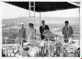
Queen Elizabeth II, Prince Phillip and officials during Royal visit to Burnaby Municipal Hall
https://search.heritageburnaby.ca/link/museumdescription3565
- Repository
- Burnaby Village Museum
- Date
- 7 May 1971
- Collection/Fonds
- Donald Copan collection
- Description Level
- Item
- Physical Description
- 1 photograph : b&w ; 12.7 x 17.8 cm
- Scope and Content
- Photograph of Queen Elizabeth II, Prince Philip, acting-mayor Hugh Ladner and his wife Valerie Ruth Ladner (in white) and officials at Burnaby Municipal Hall on May 7, 1971. The Queen is signing a proclamation.
- Repository
- Burnaby Village Museum
- Collection/Fonds
- Donald Copan collection
- Series
- Copan album series
- Description Level
- Item
- Physical Description
- 1 photograph : b&w ; 12.7 x 17.8 cm
- Scope and Content
- Photograph of Queen Elizabeth II, Prince Philip, acting-mayor Hugh Ladner and his wife Valerie Ruth Ladner (in white) and officials at Burnaby Municipal Hall on May 7, 1971. The Queen is signing a proclamation.
- Names
- Elizabeth II Queen of Great Britain, 1926-2022
- Ladner, Hugh G.
- Philip, Prince, consort of Elizabeth II, Queen of Great Britain, 1921-2021
- Ladner, Valerie Ruth Grant
- Geographic Access
- Canada Way
- Street Address
- 4949 Canada Way
- Accession Code
- BV005.54.16
- Reproduction Restriction
- May be restricted by third party rights
- Date
- 7 May 1971
- Media Type
- Photograph
- Historic Neighbourhood
- Burnaby Lake (Historic Neighbourhood)
- Planning Study Area
- Douglas-Gilpin Area
- Scan Resolution
- 600
- Scan Date
- 13-Jul-20
- Scale
- 100
- Notes
- Title based on contents of photograph
Images
Reply to Allegations of Working Class Ex-service Men's League re Relief Department Officials Membership in Fraternal Order
https://search.heritageburnaby.ca/link/councilreport63419
- Repository
- City of Burnaby Archives
- Report ID
- 55580
- Meeting Date
- 16-May-1932
- Format
- Council - Mayor/Councillor/Staff Report
- Collection/Fonds
- City Council and Office of the City Clerk fonds
- Repository
- City of Burnaby Archives
- Report ID
- 55580
- Meeting Date
- 16-May-1932
- Format
- Council - Mayor/Councillor/Staff Report
- Collection/Fonds
- City Council and Office of the City Clerk fonds
Documents
Report re Meeting with Officials of BC Electric Railway
https://search.heritageburnaby.ca/link/councilreport67055
- Repository
- City of Burnaby Archives
- Report ID
- 57863
- Meeting Date
- 5-Jun-1928
- Format
- Council - Mayor/Councillor/Staff Report
- Collection/Fonds
- City Council and Office of the City Clerk fonds
- Repository
- City of Burnaby Archives
- Report ID
- 57863
- Meeting Date
- 5-Jun-1928
- Format
- Council - Mayor/Councillor/Staff Report
- Collection/Fonds
- City Council and Office of the City Clerk fonds
Documents
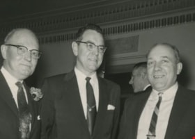
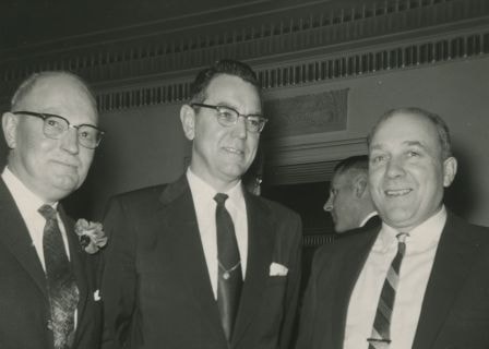
Shell Oil Officials
https://search.heritageburnaby.ca/link/archivedescription37297
- Repository
- City of Burnaby Archives
- Date
- 1958
- Collection/Fonds
- Burnaby Historical Society fonds
- Description Level
- Item
- Physical Description
- 1 photograph : b&w ; 10.3 x 13.3 cm
- Scope and Content
- Photograph of four men identified by a note on the back as Shell Oil Co. officials. The note on the back reads: "Taken at Shell Oil affair around 1958 by Nora Code then ed. [sic] of Burnaby Courier." The location of the photograph is unknown.
- Repository
- City of Burnaby Archives
- Date
- 1958
- Collection/Fonds
- Burnaby Historical Society fonds
- Subseries
- Norah Code subseries
- Physical Description
- 1 photograph : b&w ; 10.3 x 13.3 cm
- Description Level
- Item
- Record No.
- 345-018
- Access Restriction
- No restrictions
- Reproduction Restriction
- Reproduce for fair dealing purposes only
- Accession Number
- BHS1997-05
- Scope and Content
- Photograph of four men identified by a note on the back as Shell Oil Co. officials. The note on the back reads: "Taken at Shell Oil affair around 1958 by Nora Code then ed. [sic] of Burnaby Courier." The location of the photograph is unknown.
- Names
- Shell Oil Company
- Media Type
- Photograph
- Photographer
- Code, Norah
- Notes
- Title based on contents of photograph.
- Photographs in this collection were taken and compiled by Norah Code, former editor of the "Burnaby Courier" newspaper during the course of her work for the newspaper.
Images
Vacation for Municipal Officials
https://search.heritageburnaby.ca/link/councilreport74789
- Repository
- City of Burnaby Archives
- Report ID
- 80586
- Meeting Date
- 30-Aug-1909
- Format
- Council - Mayor/Councillor/Staff Report
- Collection/Fonds
- City Council and Office of the City Clerk fonds
- Repository
- City of Burnaby Archives
- Report ID
- 80586
- Meeting Date
- 30-Aug-1909
- Format
- Council - Mayor/Councillor/Staff Report
- Collection/Fonds
- City Council and Office of the City Clerk fonds
Documents

William Holmes House
https://search.heritageburnaby.ca/link/landmark736
- Repository
- Burnaby Heritage Planning
- Geographic Access
- North Road
- Brunette River
- Associated Dates
- 1860
- Heritage Value
- William Holmes is considered to be the first non-Native resident of Burnaby. In March, 1860, Holmes acquired the first land title in the area that would become the Municipality of Burnaby. Legally known as Lot One, Block One, this parcel was located on North Road and the Brunette River. The eight-member Holmes family built a log cabin on the lot on a bluff above the river in which they lived for many years until a bigger home was built. The log cabin remained and in 1892 was used as an isolation hospital when a smallpox epidemic hit the lower mainland. Afterwards, local health officials burned the cabin to prevent the spread of disease.
- Planning Study Area
- Cariboo-Armstrong Area
Images


City of Burnaby Archives
https://search.heritageburnaby.ca/link/landmark783
- Repository
- Burnaby Heritage Planning
- Geographic Access
- Albert Street
- Associated Dates
- 2001
- Heritage Value
- The City of Burnaby Archives officially opened on Saturday, November 10, 2001. The Archives is Burnaby's first municipal archives, and is located in the McGill Branch Library. The City Archives functions as a branch of the Office of the City Clerk and operates as the official repository of Burnaby's municipal records, containing records dating back to Burnaby's incorporation in 1892. In 2007, the City of Burnaby Archives expanded its collection mandate to include private as well as public records. On February 14, 2007 an agreement was signed with the Burnaby Historical Society and, as a result, the Archives accepted into its custody the collection of community records that had been maintained and managed by the Historical Society since the 1950s. In the Spring of 2007, these records were transferred from the Burnaby Village Museum to their permanent home in the Archives facility.
- Historic Neighbourhood
- Capitol Hill (Historic Neighbourhood)
- Planning Study Area
- Capitol Hill Area
- Street Address
- 4595 Albert Street
- Street View URL
- Google Maps Street View
Images


Barnet Mountain Park Dedication
https://search.heritageburnaby.ca/link/landmark686
- Repository
- Burnaby Heritage Planning
- Associated Dates
- 1942
- Heritage Value
- For years, the idea of creating a park on Burnaby Mountain was favoured by people in Burnaby. In 1930, the Municipal Engineer submitted a report recommending that the city acquire land in the area with a view towards formally dedicating the space for public use. In 1942, Commissioner Richard Bolton enacted Bylaw 1772 which officially dedicated the mountain as public park.
- Historic Neighbourhood
- Barnet (Historic Neighbourhood)
- Planning Study Area
- Burnaby Mountain Area
Images


Brentwood Neighbourhood
https://search.heritageburnaby.ca/link/landmark780
- Repository
- Burnaby Heritage Planning
- Associated Dates
- 1955-2008
- Heritage Value
- Between 1955 and 2001, the Brentwood Neighbourhood developed into one of Burnaby's four official Town Centres. The Brentwood Town Centre serves the north-west sector of the Municipality, providing facilities such as commercial developments - of which the Brentwood Mall is the most significant. Under Burnaby's Residential Development Framework adopted by Council in 1981, the Town Centre also incorporated a full range of multi-housing types and forms in close relationship with their commercial facilities. In 1996, the City adopted the Brentwood Town Centre Development Plant to solidify the area as a focus of higher-density and higher-intensity residential and commercial opportunities, public transit and supporting leisure facilities.
- Planning Study Area
- Brentwood Area
Images


Burnaby Municipal Hall
https://search.heritageburnaby.ca/link/landmark807
- Repository
- Burnaby Heritage Planning
- Geographic Access
- Canada Way
- Associated Dates
- 1956
- Heritage Value
- When staff outgrew the municipal buildings at Edmonds and Kingsway, a debate erupted over where to build a new municipal hall. North Burnaby residents argued against the Kingsway and Edmonds site as it was too removed for their needs, but South Burnaby residents were not prepared to accept a hall in North Burnaby. The debate was finally resolved when it was suggested that the new civic centre for the municipality be in the exact geographic centre of Burnaby. Fortunately, this meant that the new hall was to be built near Deer Lake, in the beautiful Central Valley setting. Burnaby voters accepted this decision and approved the $625,000.00 it would take to build the new structure and the official opening ceremony was held June 22, 1956 when then Reeve Charles MacSorley received the keys to the hall from the contractor.
- Historic Neighbourhood
- Burnaby Lake (Historic Neighbourhood)
- Planning Study Area
- Douglas-Gilpin Area
- Street Address
- 4949 Canada Way
- Street View URL
- Google Maps Street View
Images


Burnaby Village Museum
https://search.heritageburnaby.ca/link/landmark808
- Repository
- Burnaby Heritage Planning
- Geographic Access
- Deer Lake Avenue
- Associated Dates
- 1971
- Heritage Value
- The Burnaby Village Museum is a ten-acre heritage site located adjacent to Deer Lake. The site was originally created as a B.C. Centennial Project in 1971. The official sod turning for was April 11, 1971 by the then Governor General of Canada Roland Mitchener. The Village was initially managed by the Century Park Museum Association, a volunteer society of Burnaby citizens. Over the years many heritage building which could not be maintained in their original locations have been moved to the museum. Today half of the buildings in the village are heritage structures and the remainder are reproductions. In 1990 the City of Burnaby assumed direct management of the Village, and the museum became part of the Parks, Recreation and Culture Department. Visitors can enjoy the shops on Hill Street, ride the Parker 119 Carousel, and climb aboard the Interurban 1223 tram.
- Historic Neighbourhood
- Burnaby Lake (Historic Neighbourhood)
- Planning Study Area
- Douglas-Gilpin Area
- Morley-Buckingham Area
- Street Address
- 6501 Deer Lake Avenue
- Street View URL
- Google Maps Street View
Images


Confederation Park
https://search.heritageburnaby.ca/link/landmark672
- Repository
- Burnaby Heritage Planning
- Geographic Access
- Willingdon Avenue
- Associated Dates
- 1927
- Heritage Value
- North Burnaby’s first park began its life as the Capitol Hill subdivision during the land boom of 1909. In 1914 the boom went bust and many owners of unoccupied lots failed to pay the property taxes owing and the land became the property of the Municipality of Burnaby. By 1922, Burnaby had so many lots that it decided to reserve land for future park use and dedicated a narrow 26 acre site adjacent to the ravine. During the 1920s, the Heights area boomed again and many new residents wanted a playground for their children. A local women’s group took on the cause and enlisted local residents and businesses to raise the necessary funds. On June 25, 1927 crowds gathered to officially dedicate “Confederation Park” named in honour of the Diamond Jubilee of Canada’s Confederation (1867-1927).
- Historic Neighbourhood
- Capitol Hill (Historic Neighbourhood)
- Planning Study Area
- Capitol Hill Area
- Street Address
- 250 Willingdon Avenue
- Street View URL
- Google Maps Street View
Images


Mortimer-Lamb House
https://search.heritageburnaby.ca/link/landmark494
- Repository
- Burnaby Heritage Planning
- Description
- The Mortimer-Lamb House is a one and one half-storey, Arts and Crafts-style residence with a steeply pitched, side-gabled roof. The original cottage form has been enlarged with a later addition on the west side of the house. Located next to the Burnaby Lake Regional Park Wildlife Rescue Care Centre…
- Associated Dates
- c.1922
- Formal Recognition
- Community Heritage Register
- Other Names
- Harold & Katherine Mortimer-Lamb Residence
- Street View URL
- Google Maps Street View
- Repository
- Burnaby Heritage Planning
- Other Names
- Harold & Katherine Mortimer-Lamb Residence
- Geographic Access
- Glencarin Drive
- Associated Dates
- c.1922
- Formal Recognition
- Community Heritage Register
- Enactment Type
- Council Resolution
- Enactment Date
- 26/05/2003
- Description
- The Mortimer-Lamb House is a one and one half-storey, Arts and Crafts-style residence with a steeply pitched, side-gabled roof. The original cottage form has been enlarged with a later addition on the west side of the house. Located next to the Burnaby Lake Regional Park Wildlife Rescue Care Centre, the house has picturesque views of Burnaby Lake.
- Heritage Value
- Built circa 1922, the Mortimer-Lamb House is valued for its association with first owners, Harold Mortimer-Lamb (1872-1970), and his wife, Katherine Mary Mortimer-Lamb (1873-1939). Born in Leatherhead, Surrey, England, Harold Mortimer-Lamb immigrated to Canada in 1889. Seven years later in Vancouver, he married Katherine Mary Lindsay, a native of Winnipeg. Mortimer-Lamb was a key figure in the B.C. mining industry, serving as Secretary of the Mining Association of B.C. between 1900 and 1945, and also as the Secretary of the Canadian Institute of Mining and Metallurgy. In addition to his professional life, Mortimer-Lamb was a pioneer art photographer and was among Canada's leading art critics, and this house served as a central gathering place for renowned Canadian artists of the day. Mortimer-Lamb’s daughter, Molly Lamb Bobak (born 1922), became a renowned watercolourist, and was the only woman ever hired as an official Canadian war artist. The Mortimer-Lamb House is a significant example of the work of noted architect, Samuel Maclure (1860-1929) and his partner, Ross Lort (1889-1969). Maclure, who was a close friend of the Mortimer-Lamb family, was British Columbia's leading residential architect, and was renowned for his high quality designs for prominent citizens in both Vancouver and Victoria. Maclure was a leading exponent of the Art and Crafts design movement in B.C., and established a sophisticated local variation of residential architecture. The Mortimer-Lamb House was designed at the time when Maclure was in partnership with Ross Lort. In 1907, Lort began working for Maclure's firm as a draftsman, and by 1920 was in charge of Maclure's Vancouver office. Lort's architectural career spanned some sixty-years, and he designed some of the province's most familiar houses, apartments, institutions and places of worship. The Mortimer-Lamb House is also a significant local example of the Arts and Crafts style, and incorporates elements such as board-and-batten siding on the ground floor, shingled gables and leaded casement windows. It is a testament to the domestic architecture built outside of established suburbs during the post-First World War era, typically modest in scale and representative of middle-class residential ideals.
- Defining Elements
- Key elements that define the heritage character of the Mortimer-Lamb House include its: - treed setting with views of Burnaby Lake - residential form, scale and massing as expressed by its one and one-half storey height, rectangular plan and steeply pitched side-gabled roof - wood-frame construction - Arts and Crafts elements such as board-and-batten siding on the ground floor, cedar shingles in the gables and open soffits - original straight-leaded casement windows in single and multiple-assembly - internal red-brick chimney with corbelled cap
- Historic Neighbourhood
- Burnaby Lake (Historic Neighbourhood)
- Planning Study Area
- Burnaby Lake Area
- Organization
- Mining Association of B.C.
- G.F. and J. Galt Limited
- Architect
- Samuel Maclure
- Ross Lort
- Function
- Primary Historic--Single Dwelling
- Primary Current--Single Dwelling
- Community
- Burnaby Lake
- Cadastral Identifier
- P.I.D.002-977-788
- Boundaries
- The Mortimer-Lamb House is comprised of a single residential lot located at 5180 Glencairn Drive, Burnaby.
- Area
- 5652.78
- Contributing Resource
- Building
- Ownership
- Private
- Documentation
- City of Burnaby Planning and Building Department, Heritage Site Files
- Street Address
- 5180 Glencarin Drive
- Street View URL
- Google Maps Street View
Images


Richmond Park Neighbourhood
https://search.heritageburnaby.ca/link/landmark828
- Repository
- Burnaby Heritage Planning
- Associated Dates
- 1955-2008
- Heritage Value
- The Richmond Park Neighbourhood is part of the larger Edmonds Town Centre - one of four official Town Centres in the City. Richmond Park contains a residential subdivision that developed during the 1950s as well as a strong commercial and retail centre along Edmonds and Kingsway.
- Historic Neighbourhood
- Edmonds (Historic Neighbourhood)
- Planning Study Area
- Richmond Park Area
Images


Standard Oil Company / Chevron
https://search.heritageburnaby.ca/link/landmark673
- Repository
- Burnaby Heritage Planning
- Geographic Access
- Willingdon Avenue North
- Associated Dates
- 1935
- Heritage Value
- In 1935 the announcement that the California-based Standard Oil Company was going to build a huge "million dollar" refinery in Burnaby was greeted with cheers by residents who were eager for employment and good news during the Great Depression. The refinery, named Stanovan (aka: Standard Oil - Vancouver) was officially opened in 1936 with the ability to produce 2000 barrels per day. During World War Two, the capacity of the refinery doubled to assist in the war effort. In 1976, the company's name was changed to Chevron Canada Limited.
- Historic Neighbourhood
- Vancouver Heights (Historic Neighbourhood)
- Planning Study Area
- Burnaby Heights Area
- Street Address
- 355 Willingdon Avenue North
Images


St. Nicholas Anglican Church
https://search.heritageburnaby.ca/link/landmark641
- Repository
- Burnaby Heritage Planning
- Description
- Church building.
- Associated Dates
- 1912
- Street View URL
- Google Maps Street View
- Repository
- Burnaby Heritage Planning
- Geographic Access
- Triumph Street
- Associated Dates
- 1912
- Description
- Church building.
- Heritage Value
- This church was one of the first built in North Burnaby to serve the new community of Vancouver Heights. Designed by architect Frank Barrs and constructed by local builders, Arthur England and Mr. Scott, it reflected the English roots of the Anglican Church with its fine Arts and Crafts style. It was officially opened in an impressive ceremony by the Bishop of New Westminster and could accommodate 200 worshippers. It was named after Saint Nicholas, the patron saint of sailors. The adjoining parish hall was completed in 1920. The church building features a gabled roof, triangular eave brackets and a semi-octagonal apse. Stucco has been applied to the exterior, but it retains its original form, scale and massing. It now houses the Burnaby Pacific Grace Church. English-born Frank Barrs (1871-1963) arrived in Vancouver in 1907 and established an office for about one year before he began working for the Vancouver Exhibition Association. He briefly established a partnership (1912-1913) with Samuel Shewbrooks (1877-1957), and was active as an architect until about 1933.
- Locality
- Vancouver Heights
- Historic Neighbourhood
- Vancouver Heights (Historic Neighbourhood)
- Planning Study Area
- Burnaby Heights Area
- Architect
- Frank A.A. Barrs
- Area
- 1695.45
- Contributing Resource
- Building
- Ownership
- Private
- Street Address
- 3883 Triumph Street
- Street View URL
- Google Maps Street View
Images


Swangard Stadium
https://search.heritageburnaby.ca/link/landmark818
- Repository
- Burnaby Heritage Planning
- Geographic Access
- Imperial Street
- Associated Dates
- 1969
- Heritage Value
- On 26 April 1969 Swangard Stadium held its official opening. Named after Vancouver Sun former Managing Editor, Erwin Swangard, the stadium was funded entirely from private donations and civic and provincial grants.
- Historic Neighbourhood
- Central Park (Historic Neighbourhood)
- Planning Study Area
- Maywood Area
- Street Address
- 3883 Imperial Street
Images

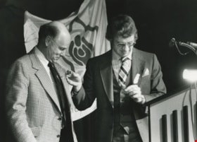
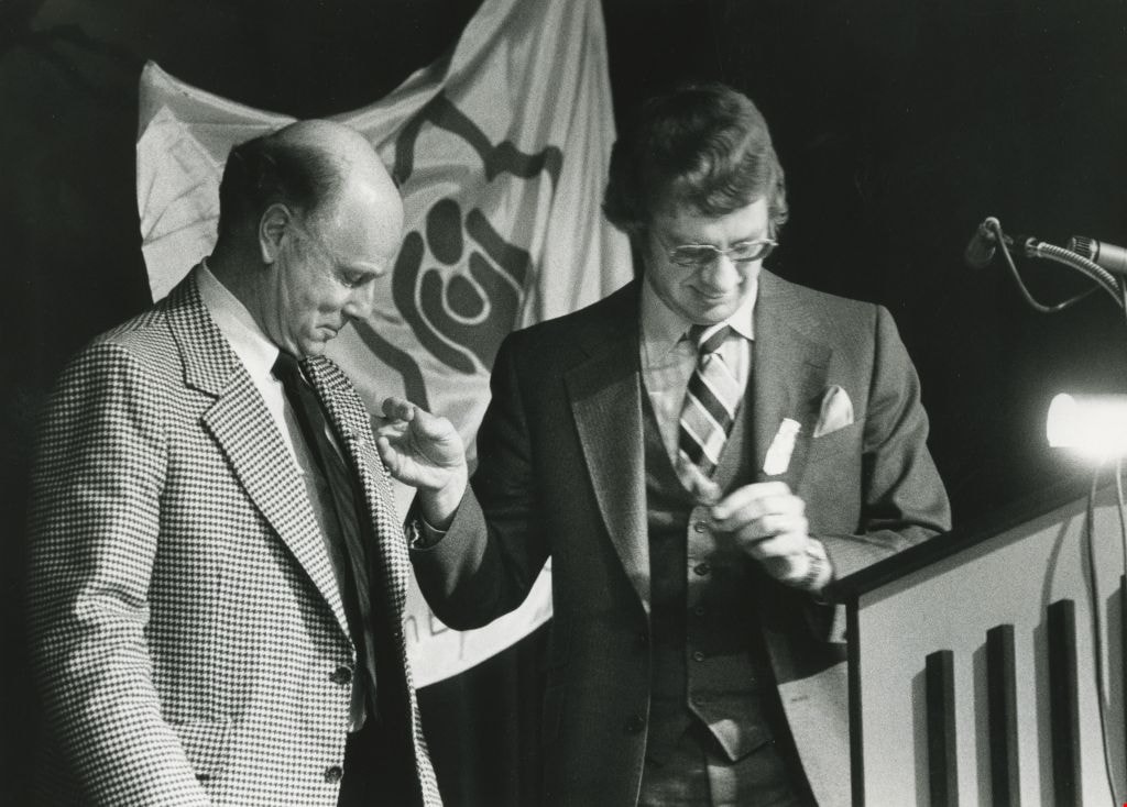
Bill Lewarne with Ray Loewen
https://search.heritageburnaby.ca/link/archivedescription45945
- Repository
- City of Burnaby Archives
- Date
- April 2, 1979
- Collection/Fonds
- Columbian Newspaper collection
- Description Level
- Item
- Physical Description
- 1 photograph : b&w ; 16 x 22 cm
- Scope and Content
- Photograph of Bill Lewarne with Ray Loewen at a microphone. Bill Lewarne was a Burnaby council member from 1973 to 1975 and from 1977 to 1987, serving as Mayor from 1981 to 1987. Ray Loewen represented the provincial constituency of Burnaby-Edmonds from 1975 to 1979, and was at one time listed as t…
- Repository
- City of Burnaby Archives
- Date
- April 2, 1979
- Collection/Fonds
- Columbian Newspaper collection
- Physical Description
- 1 photograph : b&w ; 16 x 22 cm
- Description Level
- Item
- Record No.
- 480-839
- Access Restriction
- No restrictions
- Reproduction Restriction
- No restrictions
- Accession Number
- 2003-02
- Scope and Content
- Photograph of Bill Lewarne with Ray Loewen at a microphone. Bill Lewarne was a Burnaby council member from 1973 to 1975 and from 1977 to 1987, serving as Mayor from 1981 to 1987. Ray Loewen represented the provincial constituency of Burnaby-Edmonds from 1975 to 1979, and was at one time listed as the seventeenth wealthiest person in Canada.
- Subjects
- Officials - Elected Officials
- Officials - Alderman and Councillors
- Officials - Mayors and Reeves
- Media Type
- Photograph
- Photographer
- Battistoni, Peter
- Notes
- Title based on contents of photograph
- Note on recto of photograph reads: "Ray Loewen was going to pin rose on Lewarne's lapel - stopped to check where pin was."
Images
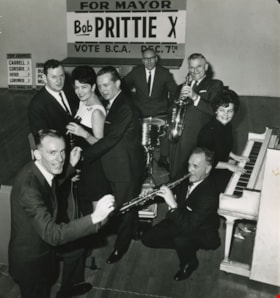
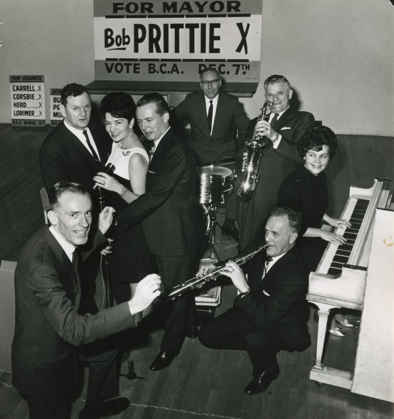
Burnaby Citizen's Association candidates
https://search.heritageburnaby.ca/link/archivedescription46016
- Repository
- City of Burnaby Archives
- Date
- 1968
- Collection/Fonds
- Columbian Newspaper collection
- Description Level
- Item
- Physical Description
- 1 photograph : b&w ; 22 x 20.5 cm
- Scope and Content
- Photograph of all of the Burnaby Citizen's Association candidates taking over the bandstand at the Burnaby Citizen's Association (BCA) dance at James Cowan Memorial Centre (now the James Cowan Theatre at The Shadbolt Centre for the Arts). The 'vocal trio' of School Board candidates; Bill Burke, Car…
- Repository
- City of Burnaby Archives
- Date
- 1968
- Collection/Fonds
- Columbian Newspaper collection
- Physical Description
- 1 photograph : b&w ; 22 x 20.5 cm
- Description Level
- Item
- Record No.
- 480-904
- Access Restriction
- No restrictions
- Reproduction Restriction
- Reproduce for fair dealing purposes only
- Accession Number
- 2003-02
- Scope and Content
- Photograph of all of the Burnaby Citizen's Association candidates taking over the bandstand at the Burnaby Citizen's Association (BCA) dance at James Cowan Memorial Centre (now the James Cowan Theatre at The Shadbolt Centre for the Arts). The 'vocal trio' of School Board candidates; Bill Burke, Caroline Prior, and Cliff Murnane. Candidates for council; Joe Corsbie on drums, Dave Herd on saxophone, Jim Lorimer on piccolo, and Del Carrell on piano, with mayoral candidate Bob Prittie as conductor. Robert W. Prittie was Mayor of Burnaby from 1969 to 1973.
- Subjects
- Officials - Alderman and Councillors
- Officials - Mayors and Reeves
- Officials - Elected Officials
- Names
- Burke, William Herbert "Bill"
- Prior, Caroline
- Murnane, Clifford J. "Cliff"
- Corsbie, Joseph Hardcastle-Cumberland "Joe"
- Herd, David M.
- Lorimer, James G "Jim"
- Carrell, Del
- Prittie, Robert W. "Bob"
- Burnaby Citizens Association
- Burnaby School Trustees
- Media Type
- Photograph
- Photographer
- Glover, Randy
- Notes
- Title based on contents of photograph
- Geographic Access
- Deer Lake Avenue
- Historic Neighbourhood
- Burnaby Lake (Historic Neighbourhood)
- Planning Study Area
- Douglas-Gilpin Area
Images