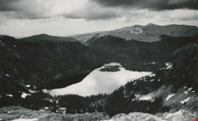
Moat Lake
https://search.heritageburnaby.ca/link/archivedescription51451
- Repository
- City of Burnaby Archives
- Date
- 1938
- Collection/Fonds
- Burnaby Historical Society fonds
- Description Level
- Item
- Physical Description
- 1 photograph : b&w postcard ; 13 x 8 cm, mounted on heavy-weight paper 17.5 x 26.5 cm
- Scope and Content
- Photographic postcard of Moat Lake nestled among the mountains of the Forbidden Plateau on Vancouver Island. This was part of a trip made by a small party of City of Courtenay officials. George A. Grant was one of the climbers in the party.
- Repository
- City of Burnaby Archives
- Date
- 1938
- Collection/Fonds
- Burnaby Historical Society fonds
- Subseries
- George Grant subseries
- Physical Description
- 1 photograph : b&w postcard ; 13 x 8 cm, mounted on heavy-weight paper 17.5 x 26.5 cm
- Description Level
- Item
- Record No.
- 243-056
- Access Restriction
- No restrictions
- Reproduction Restriction
- No known restrictions
- Accession Number
- BHS1990-06
- Scope and Content
- Photographic postcard of Moat Lake nestled among the mountains of the Forbidden Plateau on Vancouver Island. This was part of a trip made by a small party of City of Courtenay officials. George A. Grant was one of the climbers in the party.
- Media Type
- Photograph
- Photographer
- Tait, Preston L.
- Notes
- Title taken from handwritten title on paper mount
- Handwritten note on facing page reads: "So shall thy wondering sight at once survey / Vales, lakes, woods, mountains, islands, rocks and sea / Huge hills that heaped in crowded order stand / Stretched o'er the northern and the western land / Thomas Russell"
- Photographer identifies photograph as no. 835
Images

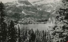
Moat Lake as viewed on Mt. Albert Edward climb
https://search.heritageburnaby.ca/link/archivedescription51452
- Repository
- City of Burnaby Archives
- Date
- 1938
- Collection/Fonds
- Burnaby Historical Society fonds
- Description Level
- Item
- Physical Description
- 1 photograph : b&w postcard ; 8 x 13 cm, mounted on heavy-weight paper 17.5 x 26.5 cm
- Scope and Content
- Photographic postcard of Moat lake, taken from Mount Albert Edward. This was part of a trip to the Forbidden Plateau on Vancouver Island made by a small party of City of Courtenay officials. George A. Grant was one of the climbers in the party.
- Repository
- City of Burnaby Archives
- Date
- 1938
- Collection/Fonds
- Burnaby Historical Society fonds
- Subseries
- George Grant subseries
- Physical Description
- 1 photograph : b&w postcard ; 8 x 13 cm, mounted on heavy-weight paper 17.5 x 26.5 cm
- Description Level
- Item
- Record No.
- 243-057
- Access Restriction
- No restrictions
- Reproduction Restriction
- No known restrictions
- Accession Number
- BHS1990-06
- Scope and Content
- Photographic postcard of Moat lake, taken from Mount Albert Edward. This was part of a trip to the Forbidden Plateau on Vancouver Island made by a small party of City of Courtenay officials. George A. Grant was one of the climbers in the party.
- Media Type
- Photograph
- Photographer
- Tait, Preston L.
- Notes
- Title taken from handwritten title on paper mount
- Handwritten note on facing page reads: "Lovest thou mountains great / Peaks to the clouds that soar / Corrie and fell where eagles dwell / And cataracts dash evermore ? / Sheriff Nicholson"
Images

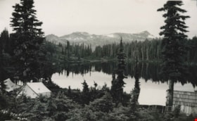
Mount Albert Edward
https://search.heritageburnaby.ca/link/archivedescription36316
- Repository
- City of Burnaby Archives
- Date
- 1938
- Collection/Fonds
- Burnaby Historical Society fonds
- Description Level
- Item
- Physical Description
- 1 photograph : b&w postcard ; 13 x 8 cm, mounted on heavy-weight paper 17.5 x 26.5 cm
- Scope and Content
- Photographic postcard of Mount Albert Edward at 6871 feet, taken from Croteau Lake. This was part of a trip to the Forbidden Plateau on Vancouver Island made by a small party of City of Courtenay officials. George A. Grant was one of the climbers in the party.
- Repository
- City of Burnaby Archives
- Date
- 1938
- Collection/Fonds
- Burnaby Historical Society fonds
- Subseries
- George Grant subseries
- Physical Description
- 1 photograph : b&w postcard ; 13 x 8 cm, mounted on heavy-weight paper 17.5 x 26.5 cm
- Description Level
- Item
- Record No.
- 243-049
- Access Restriction
- No restrictions
- Reproduction Restriction
- No known restrictions
- Accession Number
- BHS1990-06
- Scope and Content
- Photographic postcard of Mount Albert Edward at 6871 feet, taken from Croteau Lake. This was part of a trip to the Forbidden Plateau on Vancouver Island made by a small party of City of Courtenay officials. George A. Grant was one of the climbers in the party.
- Media Type
- Photograph
- Photographer
- Tait, Preston L.
- Notes
- Title taken from handwritten title on paper mount
- Handwritten note on accompanying page reads: "The Castle hath a pleasant seat / Shakespeare"
- Photographer identifies photograph as no. 764
Images

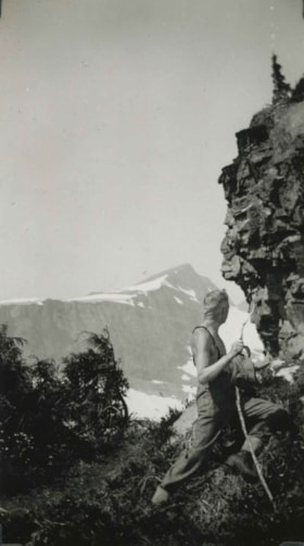
Mount Albert Edward 6871 feet
https://search.heritageburnaby.ca/link/archivedescription51455
- Repository
- City of Burnaby Archives
- Date
- July 21, 1938
- Collection/Fonds
- Burnaby Historical Society fonds
- Description Level
- Item
- Physical Description
- 1 photograph : b&w ; 13 x 8 cm, mounted on heavy-weight paper 17.5 x 26.5 cm
- Scope and Content
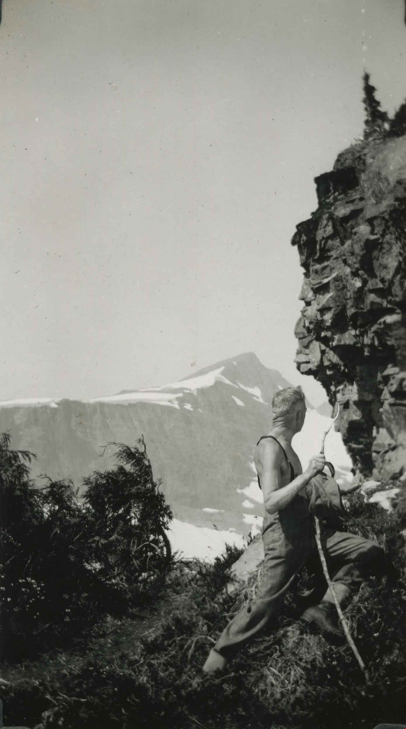
- Photograph of a hiker leaning against the rock face on Mount Albert Edward and looking at the faces that have been carved into it. Another mountain is visible in the distance. This was part of a trip to the Forbidden Plateau on Vancouver Island made by a small party of City of Courtenay officials. …
- Repository
- City of Burnaby Archives
- Date
- July 21, 1938
- Collection/Fonds
- Burnaby Historical Society fonds
- Subseries
- George Grant subseries
- Physical Description
- 1 photograph : b&w ; 13 x 8 cm, mounted on heavy-weight paper 17.5 x 26.5 cm
- Description Level
- Item
- Record No.
- 243-060
- Access Restriction
- No restrictions
- Reproduction Restriction
- No known restrictions
- Accession Number
- BHS1990-06
- Scope and Content
- Photograph of a hiker leaning against the rock face on Mount Albert Edward and looking at the faces that have been carved into it. Another mountain is visible in the distance. This was part of a trip to the Forbidden Plateau on Vancouver Island made by a small party of City of Courtenay officials. George A. Grant was one of the climbers in the party.
- Media Type
- Photograph
- Notes
- Title taken from handwritten title on paper mount
- Handwritten note on paper mount reads: "How many Cowichan Indian faces on the lookout?"
- Second handwritten note on paper mount reads: "After about 5 hours 21st JULY 1938 'Yes it looks quite a step yet, but we'll make it in a couple of hours or so."
Images
On Mt. Elma
https://search.heritageburnaby.ca/link/archivedescription51453
- Repository
- City of Burnaby Archives
- Date
- 1938
- Collection/Fonds
- Burnaby Historical Society fonds
- Description Level
- Item
- Physical Description
- 1 photograph : b&w postcard ; 13 x 8 cm, mounted on heavy-weight paper 17.5 x 26.5 cm
- Scope and Content
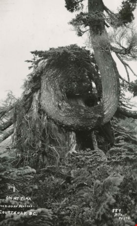
- Photographic postcard of a nursing tree growing out of a stump on Mount Elma. This was part of a trip to the Forbidden Plateau on Vancouver Island made by a small party of City of Courtenay officials. George A. Grant was one of the climbers in the party.
- Repository
- City of Burnaby Archives
- Date
- 1938
- Collection/Fonds
- Burnaby Historical Society fonds
- Subseries
- George Grant subseries
- Physical Description
- 1 photograph : b&w postcard ; 13 x 8 cm, mounted on heavy-weight paper 17.5 x 26.5 cm
- Description Level
- Item
- Record No.
- 243-058
- Access Restriction
- No restrictions
- Reproduction Restriction
- No known restrictions
- Accession Number
- BHS1990-06
- Scope and Content
- Photographic postcard of a nursing tree growing out of a stump on Mount Elma. This was part of a trip to the Forbidden Plateau on Vancouver Island made by a small party of City of Courtenay officials. George A. Grant was one of the climbers in the party.
- Subjects
- Plants - Trees
- Media Type
- Photograph
- Photographer
- Tait, Preston L.
- Notes
- Continuation of title: "...Forbidden Plateau - Courtenay, B.C."
- Handwritten note on facing page reads: "On Mount Elma 4700 ft. where we first saw the real snow."
- Photographer identifies photograph as no. 889
Images

Reflections at Croteau
https://search.heritageburnaby.ca/link/archivedescription51454
- Repository
- City of Burnaby Archives
- Date
- 1938
- Collection/Fonds
- Burnaby Historical Society fonds
- Description Level
- Item
- Physical Description
- 1 photograph : b&w postcard ; 13 x 8 cm, mounted on heavy-weight paper 17.5 x 26.5 cm
- Scope and Content
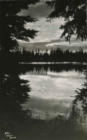
- Photographic postcard of Croteau lake at dusk. A site along the way. This was part of a trip to the Forbidden Plateau on Vancouver Island made by a small party of City of Courtenay officials. George A. Grant was one of the climbers in the party.
- Repository
- City of Burnaby Archives
- Date
- 1938
- Collection/Fonds
- Burnaby Historical Society fonds
- Subseries
- George Grant subseries
- Physical Description
- 1 photograph : b&w postcard ; 13 x 8 cm, mounted on heavy-weight paper 17.5 x 26.5 cm
- Description Level
- Item
- Record No.
- 243-059
- Access Restriction
- No restrictions
- Reproduction Restriction
- No known restrictions
- Accession Number
- BHS1990-06
- Scope and Content
- Photographic postcard of Croteau lake at dusk. A site along the way. This was part of a trip to the Forbidden Plateau on Vancouver Island made by a small party of City of Courtenay officials. George A. Grant was one of the climbers in the party.
- Media Type
- Photograph
- Photographer
- Tait, Preston L.
- Notes
- Title taken from handwritten title on paper mount
- Handwritten note on facing page reads: "True beauty dwells in deep retreats / Whose veil is unremoved / Wordsworth"
- Photographer identifies photograph as no. 820
Images

Royal Visit
https://search.heritageburnaby.ca/link/archivedescription85203
- Repository
- City of Burnaby Archives
- Date
- 1939
- Collection/Fonds
- Digney Family fonds
- Description Level
- Item
- Physical Description
- 1 film clip (1 min., 52 sec.) : digital, col., si.
- Scope and Content
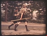
- Item is a digitized copy of a silent colour film segment with footage of the Royal Visit from King George VI and Queen consort, Elizabeth. Boy Scouts and members of the community can be seen preparing for a roadside view of the motorcade and Mr. Digney can be seen pacing in his gardens at the Oak T…
- Repository
- City of Burnaby Archives
- Date
- 1939
- Collection/Fonds
- Digney Family fonds
- Physical Description
- 1 film clip (1 min., 52 sec.) : digital, col., si.
- Description Level
- Item
- Record No.
- 562-002-2
- Access Restriction
- No restrictions
- Reproduction Restriction
- No known restrictions
- Accession Number
- 2012-15
- Scope and Content
- Item is a digitized copy of a silent colour film segment with footage of the Royal Visit from King George VI and Queen consort, Elizabeth. Boy Scouts and members of the community can be seen preparing for a roadside view of the motorcade and Mr. Digney can be seen pacing in his gardens at the Oak Theatre. As the royal couple (King George VI and Queen Elizabeth) drive by the crowd on Kingsway, they can be seen in a automobile identified as a McLaughlin model 45 Extra Special series, with Queen Elizabeth holding a white umbrella. RCMP officers are seen on a motorcycle with a side car, while dignitaries and officials in automobiles accompany the royal couple as the crowd waves red flags and looks on as the cars drive off.
- Subjects
- Events - May Day
- Events - Royal Visits
- Buildings - Commercial - Theatres
- Recreational Activities - Theatre
- Names
- Oak Theatre
- Digney, Andy
- Elizabeth, Queen, consort of George VI, King of Great Britain, 1900-2002
- George VI, King of Great Britain, 1895-1952
- Media Type
- Moving Images
- Photographer
- Digney, Andy
- Creator
- Digney, Andy
- Notes
- Title based on contents of film
- Film clip originates from digitized version of original 16 mm film footage (item 562-002). This segment was part of digitized portion titled 'Royal Visit'
- Geographic Access
- Kingsway
- Central Park
- Historic Neighbourhood
- Central Park (Historic Neighbourhood)
- Planning Study Area
- Sussex-Nelson Area
Images

Video
Royal Visit, 1939
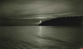
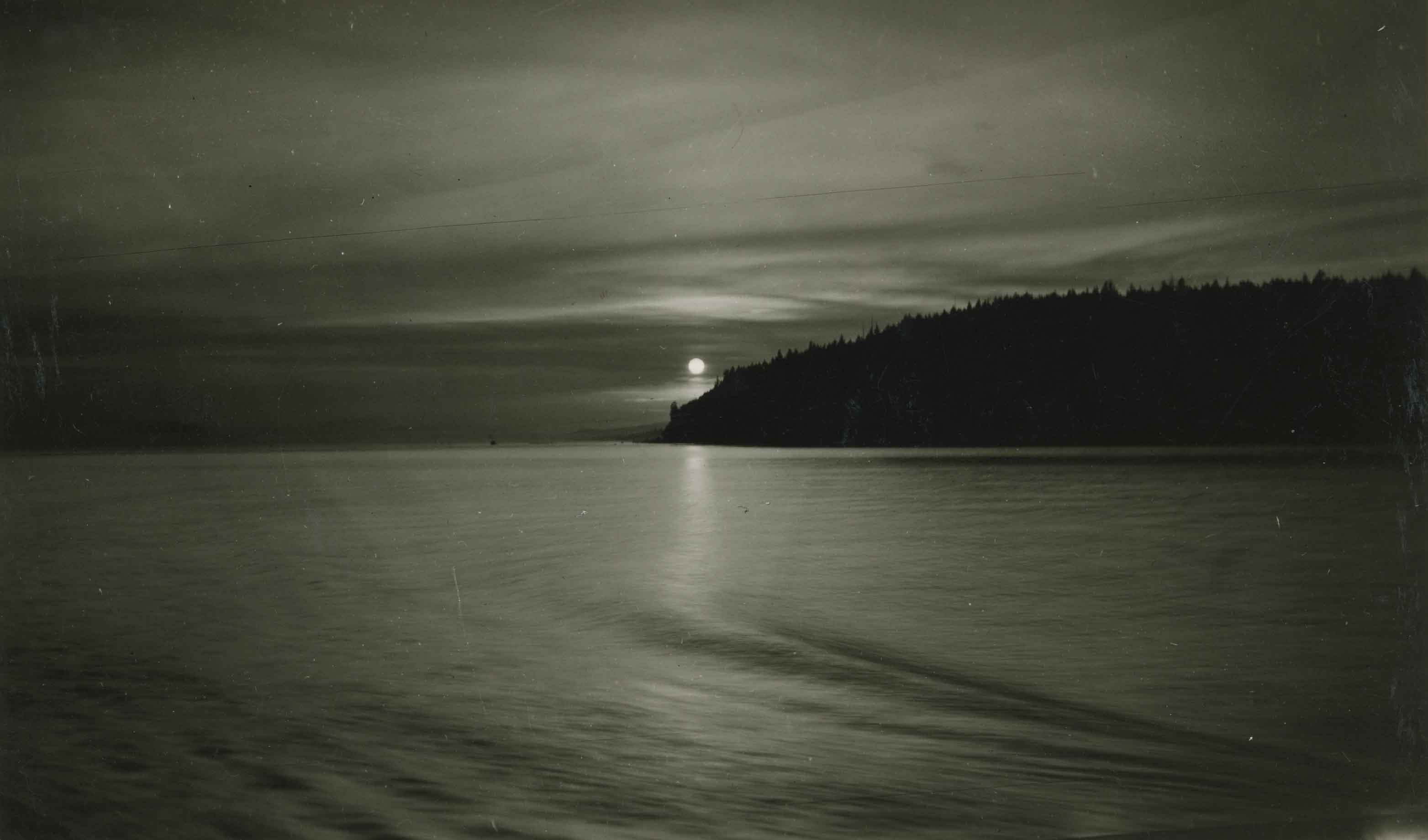
The sun sets over Gower Point
https://search.heritageburnaby.ca/link/archivedescription51459
- Repository
- City of Burnaby Archives
- Date
- 1938
- Collection/Fonds
- Burnaby Historical Society fonds
- Description Level
- Item
- Physical Description
- 1 photograph : b&w ; 8 x 13 cm, mounted on heavy-weight paper 17.5 x 26.5 cm
- Scope and Content
- Photograph of Gower Point in Gibsons as the sun is setting. This was part of a trip to the Forbidden Plateau on Vancouver Island made by a small party of City of Courtenay officials. George A. Grant was one of the climbers in the party.
- Repository
- City of Burnaby Archives
- Date
- 1938
- Collection/Fonds
- Burnaby Historical Society fonds
- Subseries
- George Grant subseries
- Physical Description
- 1 photograph : b&w ; 8 x 13 cm, mounted on heavy-weight paper 17.5 x 26.5 cm
- Description Level
- Item
- Record No.
- 243-064
- Access Restriction
- No restrictions
- Reproduction Restriction
- No known restrictions
- Accession Number
- BHS1990-06
- Scope and Content
- Photograph of Gower Point in Gibsons as the sun is setting. This was part of a trip to the Forbidden Plateau on Vancouver Island made by a small party of City of Courtenay officials. George A. Grant was one of the climbers in the party.
- Subjects
- Geographic Features - Islands
- Media Type
- Photograph
- Notes
- Title taken from handwritten title on paper mount
- Continuation of title: "...in a smoky [sic] flaming sky at close of a pleasant holiday 1938."
- Handwritten note on facing page reads: " May I go out a' climbing / On just so glad a day / And it go on without me / All sun and cloud and wind / And someone say about me / He leaves a song behind / P.R.C."
Images
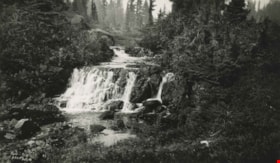
Waterfall within the Forbidden Plateau
https://search.heritageburnaby.ca/link/archivedescription51460
- Repository
- City of Burnaby Archives
- Date
- 1938
- Collection/Fonds
- Burnaby Historical Society fonds
- Description Level
- Item
- Physical Description
- 1 photograph : b&w ; 8 x 13 cm
- Scope and Content
- Photograph of a waterfall within the Forbidden Plateau on Vancouver Island. This was part of a trip made by a small party of City of Courtenay officials. George A. Grant was one of the climbers in the party.
- Repository
- City of Burnaby Archives
- Date
- 1938
- Collection/Fonds
- Burnaby Historical Society fonds
- Subseries
- George Grant subseries
- Physical Description
- 1 photograph : b&w ; 8 x 13 cm
- Description Level
- Item
- Record No.
- 243-065
- Access Restriction
- No restrictions
- Reproduction Restriction
- No known restrictions
- Accession Number
- BHS1990-06
- Scope and Content
- Photograph of a waterfall within the Forbidden Plateau on Vancouver Island. This was part of a trip made by a small party of City of Courtenay officials. George A. Grant was one of the climbers in the party.
- Subjects
- Geographic Features - Waterfalls
- Media Type
- Photograph
- Photographer
- Tait, Preston L.
- Notes
- Title based on contents of photograph
- Photographer identifies photograph as no. 944
Images

William Holmes fonds
https://search.heritageburnaby.ca/link/museumdescription10416
- Repository
- Burnaby Village Museum
- Date
- [1841]-1994
- Collection/Fonds
- William Holmes fonds
- Description Level
- Fonds
- Physical Description
- 2 photographs (calotype) + 1 photograph : b&w + 6 photographs : col. + 5 p. textual records + 1 newspaper clipping
- Scope and Content
- Fonds consists of photographs pertaining to the William Holmes family, family grave markers in cemetery in Ireland along with original correspondence, land title certificates and a newspaper clipping. Fonds is arranged in series: 1) William Holmes family photographs series 2) William Holmes family…
- Repository
- Burnaby Village Museum
- Collection/Fonds
- William Holmes fonds
- Description Level
- Fonds
- Physical Description
- 2 photographs (calotype) + 1 photograph : b&w + 6 photographs : col. + 5 p. textual records + 1 newspaper clipping
- Scope and Content
- Fonds consists of photographs pertaining to the William Holmes family, family grave markers in cemetery in Ireland along with original correspondence, land title certificates and a newspaper clipping. Fonds is arranged in series: 1) William Holmes family photographs series 2) William Holmes family records series 3) Holmes family cemetery photographs series
- History
- William Holmes was the first non-Indigenous resident of Burnaby and was born in Kilkenny Ireland January 4, 1812. In 1833, at the age of 20 yrs, William Holmes immigrated to Canada from Ireland in with his parents, Joseph and Jane (McCullough) Holmes and ten other family members including two of his married brothers and their wives, two sisters with their husbands and two unmarried brothers. This was the first group of thirteen to leave Ireland and set up homesteads in Canada near the shores of Lake Huron. The family settled on land concessions in Huron County, Ontario about 14 km southeast of Goderich. The area in Huron County was first founded in 1832 by John and Samuel Holmes and the community was known as Holmes Hill before becoming Holmesville [ca. 1850]. In 1837, William Holmes is noted as owning Lot 23, Concession IX, Goderich Twp. Much of the village of Holmesville grew up around the five road concession near the border of his brother’s farm so William decided to open a store. The Holmesville post office opened on March 1, 1855 and William was appointed the first post master which he operated until May 1857. William met and married Mary Richardson in 1841 and the couple had three daughters: Jane (1844-1926) (married Charles Studdert Finlaison in New Westminster in 1863); Anne Maria (Annie) (1846-192?) (married John Gunther Jennings in New Westminster in 1865 and married Robert Johnson in New Westminster in 1877) and Elizabeth (1848-1934) (married Thomas Carrington of Lakes District in 1867). William’s wife, Mary (Richardson) Holmes died in Holmesville sometime between 1848 and 1853. Following the death of his first wife, Mary, William married Charlotte McCullough (McCulloch). The couple had four daughters; Arabella Charlotte Amelia (1854-1943) (married Arthur Robert Green in 1887); Laura (1855-1867); Arabella Henrietta (1857-1929) (married Clark Wesley Gillanders in 1880) and Mary (1863-1864). During the late 1850s, William became aware of the gold rush and opportunities opening up in British Columbia so left for the west coast in 1858 at the age of 46 yrs. In preparation for his move to the west coast of Canada, William obtained a letter of introduction from top government officials of Canada. William Holmes arrived in British Columbia in 1859. Upon arriving, he first worked running pack trains from Harrison Mills to Lillooet. After earning some money, he decided to re-invest it in land. His first pre-emption of land occurred on January 21, 1860 for 160 acres situated on North Road from the Military Camp to Burrard Inlet and distancing 25 chains south of the Brunette River and 20 chains south of the river with the land extending in a westerly direction. On March 17, 1860, Holmes received a Crown Grant for this and other land in the immediate area totalling 415 acres of which was known as Lot No. 1, Group 1, Rural Land, New Westminster District. The balance of land was situated on the east side of the Brunette River – Lot 13, with 344 2/3 acres of which he made an application to purchase on June 26, 1860, and a Crown Grant dated March 16, 1861 covering 86 acres. Holmes also pre-empted land in Port Moody and Pitt Meadows in 1860 and 1861. The name of “Brunette River” is officially attributed to William Holmes who referred to the river as “Brunette” due to it’s dark colour originating from the peat lands above the lake. Following his purchase of property, he sent for his wife Charlotte, their three daughters and her three step daughters (from William’s first marriage). Charlotte and the six children made the long trip to B.C. by ship and rail, crossing the Isthmus of Darien at Panama. They arrived in B.C. in October 1861 and moved into a one room log cabin built by William. The cabin stood on the North Road at the foot of Sapperton, on a bluff overlooking the Brunette River. Eventually the family moved to a larger dwelling but the original cabin remained on the site until the 1890s when it was burned after being used as a sick house. Mr. Holmes was instrumental in organizing the first Orange Lodge in British Columbia. He was a prominent Orangeman who joined the order in 1840 and was the first master in the order of the City of New Westminster when the Lodge No. 1150 was established there. Charlotte Holmes died in New Westminster in 1893 at the age of 70 years and William Holmes died in New Westminster September 11, 1907 at the age of 95 years.
- Responsibility
- Holmes, William
- Accession Code
- HV971.46
- BV997.50
- Date
- [1841]-1994
- Media Type
- Photograph
- Textual Record
- Related Material
- See also: Reference file: Persons - Holmes, William
- Notes
- Title based on contents of fonds
City of Burnaby Archives photograph collection
https://search.heritageburnaby.ca/link/archivedescription93710
- Repository
- City of Burnaby Archives
- Date
- [1920]-[1979]
- Collection/Fonds
- City of Burnaby Archives photograph collection
- Description Level
- Fonds
- Physical Description
- 43 photographs (39 tiffs ; 2 jpegs ; 3 col. prints, 9 x 9 cm) and 3 p. of textual records
- Scope and Content
- Collection consists of photographs that were selected for preservation because of their relevance to documenting the heritage and development of the City of Burnaby. The items in this collection depict Burnaby citizens, locations, businesses, residences, geography, and events throughout the history…
- Repository
- City of Burnaby Archives
- Date
- [1920]-[1979]
- Collection/Fonds
- City of Burnaby Archives photograph collection
- Physical Description
- 43 photographs (39 tiffs ; 2 jpegs ; 3 col. prints, 9 x 9 cm) and 3 p. of textual records
- Description Level
- Fonds
- Access Restriction
- No restrictions
- Reproduction Restriction
- May be restricted by third party rights
- Accession Number
- 2010-01
- 2013-31
- 2016-24
- 2021-10
- Scope and Content
- Collection consists of photographs that were selected for preservation because of their relevance to documenting the heritage and development of the City of Burnaby. The items in this collection depict Burnaby citizens, locations, businesses, residences, geography, and events throughout the history of the City of Burnaby. The items in this collection are acquisitions of discrete items or small sets of items that do not form a discrete fonds or collection.
- History
- Burnaby’s first municipal archive officially opened on November 10, 2001, and is located in the McGill Branch Public Library at 4595 Albert Street. The City Archives functions as a branch of the Office of the City Clerk and operates as the official repository of Burnaby’s municipal records, containing records dating back to Burnaby’s incorporation in 1892. In 2007, the City of Burnaby Archives expanded its collection mandate to include private as well as public records. Types of records held at the Archives include City Records (Council minutes and reports, bylaws, departmental records and photographs) and records from private individuals and community organizations (correspondence, reports, minutes, photographs, moving images and sound recordings). The Archives storage area is equipped with the sophisticated environmental controls necessary to preserve Burnaby’s unique archival material into the future. The mandate of the City of Burnaby Archives is to identify, acquire, preserve and make accessible archival material in the form of civic and private records documenting the history of the City of Burnaby.
- Media Type
- Textual Record
- Photograph
- Creator
- City of Burnaby Archives
- Notes
- Title based on contents of collection.
![Copy of Official British Columbia Road Maps, [193-] thumbnail](/media/hpo/_Data/_BVM_Cartographic_Material/1972/1972_0179_0001_001.jpg?width=280)
Copy of Official British Columbia Road Maps
https://search.heritageburnaby.ca/link/museumdescription18945
- Repository
- Burnaby Village Museum
- Date
- [193-]
- Collection/Fonds
- Burnaby Village Museum Map collection
- Physical Description
- 1 map : lithographic print on sheet ; 43 x 56 cm folded to 22 x 11 cm
- Scope and Content
- Item consists of Road maps of British Columbia presented by Union Oil Company of Canada Limited. Includes seventeen maps printed on both sides of sheet. One side of sheet includes ten separate road maps titled "Cariboo"; "Chilcotin Plateau"; "150 Mile House to Prince George"; "Prince George - Burns…
- Repository
- Burnaby Village Museum
- Collection/Fonds
- Burnaby Village Museum Map collection
- Physical Description
- 1 map : lithographic print on sheet ; 43 x 56 cm folded to 22 x 11 cm
- Material Details
- Scale not defined
- Scope and Content
- Item consists of Road maps of British Columbia presented by Union Oil Company of Canada Limited. Includes seventeen maps printed on both sides of sheet. One side of sheet includes ten separate road maps titled "Cariboo"; "Chilcotin Plateau"; "150 Mile House to Prince George"; "Prince George - Burns Lake"; "Burns Lake - Hazelton"; "Similkameen - Nicola"; "Salmon Arm to Revelstoke"; "Ashcroft to Salmon Arm / Kamloops to Vernon"; "Okanagan Valley"; "Boundary District". Other side of sheet includes seven road maps titled "Vancouver Island"; "Vancouver to Yale"' "Fraser Canyon Section Cariboo Road"; "Lytton to 150 Mile House"; "Arrow and Kootenay Lakes"; "The Kootenays"; "Columbia Valley". When folded, cover of maps reads "COPY OF / OFFICIAL / BRITISH COLUMBIA / ROAD-MAPS" / Presented by / UNION OIL / COMPANY / of Canada Ltd."; verso of cover includes advertisement for Union Motor oil "MOTORITE"; inside cover includes advertisement for Union Gasoline with title reading "See Canada's Evergreen Playground".
- Responsibility
- Union Oil Company of Canada Limited
- Accession Code
- HV972.179.1
- Access Restriction
- No restrictions
- Reproduction Restriction
- No known restrictions
- Date
- [193-]
- Media Type
- Cartographic Material
- Scan Resolution
- 600
- Scan Date
- 2023-08-17
- Notes
- Title based on contents of map
Images
![Copy of Official British Columbia Road Maps, [193-] thumbnail](/media/hpo/_Data/_BVM_Cartographic_Material/1972/1972_0179_0001_001.jpg)

Glimpses of the East : N.Y.K. official guide
https://search.heritageburnaby.ca/link/museumlibrary2386
- Repository
- Burnaby Village Museum
- Author
- Kawata, Tomoyuki
- Publication Date
- 1930
- Call Number
- 910.95091 KAW
- Repository
- Burnaby Village Museum
- Collection
- Special Collection
- Material Type
- Book
- Accession Code
- HV976.118.1
- Call Number
- 910.95091 KAW
- Author
- Kawata, Tomoyuki
- Contributor
- Nihon Yusen Kabushiki Kaisha
- Place of Publication
- Tokyo
- Publisher
- T. Kawata
- Publication Date
- 1930
- Physical Description
- 1 v. (various pagings) : ill. (some col.), maps (some col.) : 27 cm.
- Library Subject (LOC)
- Commerce
- East Asia--Description and travel
- East Asia--Commerce
- Directories
- Notes
- "1929 --- Twelfth Annual Issue --- 1930"--title page
- "Official Shipper's & Traveller's Guide to all the Principal Ports of the World..." --title page
- "T. Kawata, Editor & Publisher"--title page
J.P. Dickson subseries
https://search.heritageburnaby.ca/link/archivedescription58383
- Repository
- City of Burnaby Archives
- Date
- 1920-1939 (dates of originals)
- Collection/Fonds
- Burnaby Historical Society fonds
- Description Level
- Subseries
- Physical Description
- Textual records and photographs
- Scope and Content
- Subseries consists of photocopied scrapbook pages as well as three original photographs pertaining to J.P. Dickson.
- Repository
- City of Burnaby Archives
- Date
- 1920-1939 (dates of originals)
- Collection/Fonds
- Burnaby Historical Society fonds
- Subseries
- J.P. Dickson subseries
- Physical Description
- Textual records and photographs
- Description Level
- Subseries
- Accession Number
- BHS1992-51
- Scope and Content
- Subseries consists of photocopied scrapbook pages as well as three original photographs pertaining to J.P. Dickson.
- History
- James P. Dickson was born in Peeblesshire, Scotland. He came to Manitoba first in 1905 when he was 21 years old, but didn’t move to British Columbia until 1909 when he started the Dickson Brothers Flower Shop and Nursery at 3271 Kingsway. He was a landscape gardener, designing the garden for the Model Burnaby Home at the Royal City Fair in 1920 and designing Burnaby exhibits at the provincial fairs at New Westminster in 1922 and 1923. In 1922 he spoke at a South Vancouver Horticultural Association event; the subject of his talk was “Natural Gardens.” J.P. Dickson was a Burnaby School Board Trustee from 1921 to 1924 (chairman in 1924), 1927 to 1932 (chairman from 1929 to 1932) and 1943 to 1944. In 1925 he was the Labour Party Candidate for Reeve of Burnaby. In 1930 he was president of the May Day committee and officiated at the crowning. J.P. Dickson attended the British Columbia School Trustees Association 26th Annual Convention in Vernon with his family and served as the association’s president from 1932 to 1933. The Dickson family lived at 1519 (later 7770) Nelson Avenue, Burnaby. J.P. had at least one child born about 1913, who attended South Burnaby High School in his teen years. According to “Burnaby: A Proud Century” by Pixie McGeachie James Dickson is also known for his part in creating an unofficial presentation to the King George and Queen Elizabeth during their royal visit in 1939. There was no official stop scheduled for Burnaby, but he persuaded the parade marshal beforehand to slow the procession as it approached Royal Oak (and the Chamber of Commerce built a viewing platform there to attract a large crowd). Dickson encouraged everyone to move in to narrow the width of passage on Kingsway. As the royal car appeared on Royal Oak, the crowd surged forward and blocked its path. A Burnaby girl rushed towards the car waving a bouquet from the Dickson Brothers Flower Shop and an aide-du-camp passed it directly to the Queen “who acknowledged the gift with approval just as the car began to move again.”
- Media Type
- Textual Record
- Photograph
- Creator
- Dickson, James P.
- Notes
- Title based on contents of subseries
- PC308 and MSS079
North Burnaby Board of Trade subseries
https://search.heritageburnaby.ca/link/archivedescription124
- Repository
- City of Burnaby Archives
- Date
- [1920]-[1958]
- Collection/Fonds
- Burnaby Historical Society fonds
- Description Level
- Subseries
- Physical Description
- Textual records and photographs
- Scope and Content
- Subseries consists of documents related to the North Burnaby Board of Trade (previously Burnaby Board of Trade), including its certificate of formation, reports and bylaws pertaining to both the Burnaby Fire Department and Barnet Park, correspondence, District of Burnaby financial reports, annual r…
- Repository
- City of Burnaby Archives
- Date
- [1920]-[1958]
- Collection/Fonds
- Burnaby Historical Society fonds
- Subseries
- North Burnaby Board of Trade subseries
- Physical Description
- Textual records and photographs
- Description Level
- Subseries
- Accession Number
- BHS2005-08
- Scope and Content
- Subseries consists of documents related to the North Burnaby Board of Trade (previously Burnaby Board of Trade), including its certificate of formation, reports and bylaws pertaining to both the Burnaby Fire Department and Barnet Park, correspondence, District of Burnaby financial reports, annual reports, a map, and photographs of Burnaby parks, schools and neighbourhoods.
- History
- The Burnaby Board of Trade formed on September 4, 1926 and registered with the province December 14, 1926. George Conway Brown was elected as Secretary. On May 30, 1927, The Governor General officially granted the Board to change its name to the North Burnaby Board of Trade. The Board's boundaries, under Secretary Thomas B. Blake, were changed from "the Municipality of Burnaby" to "that portion of the Municipality of Burnaby which lies north of Still Creek, Burnaby Lake and Brunette River" British Columbia. On April 26, 1932, the North Burnaby Board of Trade Constitution and Bylaws were adopted with A.G. Kidd as Secretary. Membership was open to all persons directly or indirectly engaged or interested in the trade and commerce or the economic welfare of the district of North Burnaby. The Secretary was the executive officer of the Board, ordered to keep the books, conduct the correspondence, preserve official documents, take minutes at all meetings, have custody of the seal and be in charge of all funds and accounts held by the Board. The North Burnaby Board of Trade was involved in many historic municipal decisions including the development of Barnet Park and establishing a unified Fire Department under one Fire Chief.
- Media Type
- Textual Record
- Photograph
- Creator
- North Burnaby Board of Trade
- Notes
- PC476, MSS118
- Title based on contents of subseries
Wrigley's Official Arrow City map of Greater Vancouver and New Westminster
https://search.heritageburnaby.ca/link/archivedescription65838
- Repository
- City of Burnaby Archives
- Date
- 1936
- Collection/Fonds
- Burnaby Historical Society fonds
- Description Level
- Item
- Physical Description
- 1 map : blueprint ink on paper ; 60 x 85 cm folded to 25 x 11 cm in cover
- Scope and Content
- Item is Wrigley's Official Arrow City map of Greater Vancouver and New Westminster, published by Roy Wrigley Printing & Publishing Co. Ltd. in Vancouver. Map includes a street index of "Vancouver and [the] Lower Mainland." The maps shows main streets, bus lines, interurban lines, street car lines a…
- Repository
- City of Burnaby Archives
- Date
- 1936
- Collection/Fonds
- Burnaby Historical Society fonds
- Subseries
- Ephemera subseries
- Physical Description
- 1 map : blueprint ink on paper ; 60 x 85 cm folded to 25 x 11 cm in cover
- Material Details
- Scale : 1 inch = 3000 feet
- Cover is in col. and is attached to corner of map
- Description Level
- Item
- Record No.
- 42693
- Accession Number
- BHS1986-43
- Scope and Content
- Item is Wrigley's Official Arrow City map of Greater Vancouver and New Westminster, published by Roy Wrigley Printing & Publishing Co. Ltd. in Vancouver. Map includes a street index of "Vancouver and [the] Lower Mainland." The maps shows main streets, bus lines, interurban lines, street car lines and numbers.
- Media Type
- Cartographic Material
- Notes
- Interior map is entitled "Wrigley's NEW Map of Vancouver and Lower Mainland"
Burnaby Girl Guides fonds
https://search.heritageburnaby.ca/link/museumdescription4614
- Repository
- Burnaby Village Museum
- Date
- 1914-2009
- Collection/Fonds
- Burnaby Girl Guides fonds
- Description Level
- Fonds
- Physical Description
- 22 scrapbooks : photographs + textual records + illustrations + digital files : col. (pdfs) + photographs : col. (tiffs) + col. (jpegs) + 222 photographs : b&w ; col. + 12 cm of textual records + ephemera
- Scope and Content
- Fonds consists of a collection of scrapbooks containing photographs, textual records, illustrations and ephemera along with individual photographs and textual records related to Burnaby Girl Guides. Records document the activities and functions of Burnaby Girl Guides through histories, journals, ne…
- Repository
- Burnaby Village Museum
- Collection/Fonds
- Burnaby Girl Guides fonds
- Description Level
- Fonds
- Physical Description
- 22 scrapbooks : photographs + textual records + illustrations + digital files : col. (pdfs) + photographs : col. (tiffs) + col. (jpegs) + 222 photographs : b&w ; col. + 12 cm of textual records + ephemera
- Scope and Content
- Fonds consists of a collection of scrapbooks containing photographs, textual records, illustrations and ephemera along with individual photographs and textual records related to Burnaby Girl Guides. Records document the activities and functions of Burnaby Girl Guides through histories, journals, newspaper clippings, certificates, awards, programmes, photographs, illustrations and newsletters. Scrapbooks were created by Burnaby Girl Guides and Girl Guide leaders and deposited with the Burnaby Girl Guide Archivist prior to being donated to the Burnaby Village Museum. Record descriptions are available at both item and file level. Fonds is arranged into the following series: 1) Burnaby Girl Guides scrapbooks and photographs series 2) Burnaby Girl Guides administrative records and histories series 3) Burnaby Girl Guides newsletters series 4) Burnaby Girl Guides memorabilia series
- History
- The Girl Guide Movement began in England in 1909 when girls in England demanded to take part in a Boy Scouts rally at the Crystal Palace in London, organized by Chief Scout and Boy Scout founder Lord Robert Baden-Powell. Following this event, Baden Powell asked his sister, Agnes Baden-Powell to help him start a similar organization for girls and Girl Guides was formed. Girl Guides came to Canada in 1910 and the first troop in British Columbia was registered in Victoria in 1912. In 1913 Amy Leigh moved to Burnaby from England and enquired about a Guiding company in her area and was disappointed to find none. On June 11, 1914 at the age of 17 years, Amy registered the 1st Burnaby Girl Guide Company and became the captain. On April 2, 1916 the 2nd Burnaby Guide Company registered and met at Edmonds School. In this same year, the very first Burnaby Girl Guide Rally event took place at Central Park and by 1920 another took place at the Burnaby Municipal Hall (Edmonds) and was attended by both Burnaby and New Westminster Guides. The First Burnaby Brownie Pack was registered on December 1922 with Mrs. W.J. Matherson as Brown Owl. The Brownie Pack met in a West Burnaby facility. The First Burnaby Land Ranger Co. was formed on November 29, 1923 and by 1924 Burnaby became a District with four Guide companies, four Brownie Packs and the Rangers. In 1923 records show Mrs. Gavin as commissioner, Mrs. C.F. Carter in 1924 and Miss Amy Leigh between 1926 and 1928. The first District camp was held near Sechelt in 1927 on the property of Mrs. Deal and Mrs. Nixon with annual camps held here until 1930 when the Guide camp at Wilson Creek was established. In 1929 Guides and Brownies began taking part in the Annual May Day Celebrations at Central Park. In 1930 Burnaby became a Division with Mrs. C.F. Carter as Division Commissioner and Mrs. G. Peel as District Commissioner for South Burnaby and in 1931 Miss Amy Leigh became the first North Burnaby Commissioner. The 5th Burnaby Girl Guide Company in North Burnaby began publishing a bulletin in 1935. In this same year Burnaby Girl Guides attended a rally for Lord and Lady Powell who were visiting Vancouver and Burnaby Girl Guides became affiliated with Greater Vancouver Girl Guide Council. The packs and companies of North Burnaby were attached to the eastern section of Vancouver while South Burnaby and South Vancouver District became another Division. Mrs. Pochin organized the Burnaby Lake District in 1943 becoming the first District commissioner (In 1927 Mrs. Peel had guides in this area). The first training classes for Girl Guides were held in 1943 in a hall on Buller Avenue at the BCER tracks and also Phillips Hall on McKay Avenue. By 1945 a training camp was held on Mrs. Pochin’s property on Deer Lake. South Vancouver, South Burnaby and Burnaby Lake Districts took part in the training which was a change over from war time service and the return of Pioneer camping. Miss E. Perition was in charge of camp which was attended by Mrs. J. Quinnell, Mrs. J. Albertson and many guiders. In 1946 Lady Baden Powel returned for a visit to Vancouver and there was a rally at Connaught Park and Chief Scout Lord Rowallyn held a rally at Brocton Point. In 1947 Mrs. J. Albertson became Division Commissioner for South Vancouver and South Burnaby. Districts of Burnaby Lake and South Burnaby each adopted a European child and undertook to send regular parcels and by 1948 these Districts became a Burnaby Division once more under Division Commissioner Mrs. W.M. Wall. In September 1949 the first Sea Ranger Crew “S.R.S. Royal Oak” was formed under the Skipper, Miss E. Periton. The S.R.S. Royal Oak met at All Saint’s Church Hall on Royal Oak Ave. In 1950 Packs and Companies in North Burnaby organized into a District under Mrs. Hebron and in 1953 Sperling District was organized by District Commissioner Mrs. Hancock. 1953 was also the same year that South Burnaby District was divided into three Districts: Central Park District under Commissioner Miss Perition, Douglas District under Commissioner Mrs. J. McKee Wilson and Kingsway under Commissioner Mrs. J.G. Fowler. A few years later, in 1955 the guides and brownies were out in force to welcome Lady Baden Powel at a rally held in the PNE Gardens building and by March 1956 Burnaby ceased to be a part of Greater Vancouver Area and was organized under two Divisions of the Province. The Sperling, Willingdon and Vancouver Heights Districts in North Burnaby became North Burnaby Division with Mrs. H. Hebron as Division Commissioner. With rapid population growth further decentralization became necessary and South Burnaby Division was split in two, adding the new division of Central Burnaby under Commissioner Miss E. Perition. Central Burnaby was composed of three Districts: Burnaby Lake, Central Park and a new District named “Windsor” under Mrs. C. Dumfries. South Burnaby was composed of three Districts: Kingsway, Edmonds and Lakeview (the latter two also referred to as Douglas with Mrs. McGeachie and Mrs. J. Park as the first commissioners of these two Districts). In 1957 Burnaby became an Area unto itself with three Divisions, and 9 Districts under Miss Periton as the first Area Commissioner. In February 1957, Burnaby entered into a contract with Vancouver Girl Guide Council to lease a part of the Wilson Creek campsite. Under the leadership of Area Commissioner, Miss Periton, work started on the development of the site with funds raised by both the Girl Guides, local citizens and associations. A camp committee was formed with representation from each Division and a lot of help from Miss Norah Weller, the Wilson Creek camp manager. Plans were laid for the site with a dining shelter, store room and cook stove contracted for while a subcommittee of men was appointed to purchase building supplies and organize work parties to build cabins, a staff house, water pipes and sanitary facilities. The site opened in May 1958 with $6000 expended on building and equipping the camp, while an official opening took place on June 8 and by July Girl Guides began camping on the site. The Burnaby Area Committee became a member of the Burnaby Community Council and a participant in Community Chest in 1958 and on May 1, the Burnaby Area office opened. By 1959, with further participation in North Burnaby, Sperling District was split to form Sperling and Hillview Districts and by 1960 Kingsway District of South Burnaby split to form Kingsway and Royal Oak Districts. By December 1960, Burnaby Area had 3 Divisions, 11 Districts with a total membership of 2, 331.
- Creator
- Girl Guides of Canada
- Accession Code
- BV015.35
- BV015.36
- BV016.49
- Access Restriction
- No restrictions
- Reproduction Restriction
- May be restricted by third party rights
- Date
- 1914-2009
- Media Type
- Textual Record
- Photograph
- Notes
- Title based on contents of fonds
- Some scrapbooks are only available in digital formats
- Accessions that form part of this fonds include: BV015.35; BV015.36; BV016.49
Civic ceremonies, awards and special events series
https://search.heritageburnaby.ca/link/archivedescription157
- Repository
- City of Burnaby Archives
- Date
- 1919-2004
- Collection/Fonds
- Mayor's Office fonds
- Description Level
- Series
- Scope and Content
- Series contains records created by the Mayor’s Office during the Mayor’s participation in civic ceremonies, awards presentations, or other special events undertaken in or for the City of Burnaby. Records include: photographs, correspondence, memoranda, speeches, reports, newspaper clippings, progr…
- Repository
- City of Burnaby Archives
- Date
- 1919-2004
- Collection/Fonds
- Mayor's Office fonds
- Description Level
- Series
- Scope and Content
- Series contains records created by the Mayor’s Office during the Mayor’s participation in civic ceremonies, awards presentations, or other special events undertaken in or for the City of Burnaby. Records include: photographs, correspondence, memoranda, speeches, reports, newspaper clippings, programmes, agendas, proclamations, plaques, itineraries, invitations, and ceremonial certificates and memorabilia. As the official representative for the citizens of Burnaby, the Mayor hosts and attends numerous ceremonies and special events throughout his/her term in office. Included in this series are records from events such as the 1984 and 1997 B. C. Summer Games, the 1992 Burnaby Centennial celebrations, and the 1971 Royal Visit from Queen Elizabeth and Prince Philip. During the course of these events, the City of Burnaby often is presented with ceremonial plaques, letters, or certificates that commemorate the special occasions and this material is included in the series. The Mayor is also responsible for seeing that awards are bestowed upon other deserving parties and ensures that achievements and special occasions are formally recognized by the City of Burnaby. Each year the Mayor presents the Kushiro Cup Award – which is named after Burnaby’s Sister City Kushiro, Japan – to an outstanding Burnaby resident and hosts such functions as municipal appreciation dinners. The records that are produced while carrying out these activities include criteria lists, resumes, correspondence, proclamations, and certificates.
- Media Type
- Textual Record
Coronation and celebration papers
https://search.heritageburnaby.ca/link/archivedescription57771
- Repository
- City of Burnaby Archives
- Date
- 1927-1937
- Collection/Fonds
- Burnaby Historical Society fonds
- Description Level
- File
- Physical Description
- 1 file of textual records
- Scope and Content
- File consists of papers pertaining to celebrations attended by George Jeffery. Included in the file are brochures entitled, "Canada's Diamond Jubilee of Confederation / July 2nd / Burnaby's Official Programme" and "Civic Coronation Service / Sunday, May the Ninth, Nineteen Hundred and Thirty-Seven"…
- Repository
- City of Burnaby Archives
- Date
- 1927-1937
- Collection/Fonds
- Burnaby Historical Society fonds
- Subseries
- George Jeffery subseries
- Physical Description
- 1 file of textual records
- Description Level
- File
- Record No.
- MSS013-017
- Accession Number
- BHS2007-04
- Scope and Content
- File consists of papers pertaining to celebrations attended by George Jeffery. Included in the file are brochures entitled, "Canada's Diamond Jubilee of Confederation / July 2nd / Burnaby's Official Programme" and "Civic Coronation Service / Sunday, May the Ninth, Nineteen Hundred and Thirty-Seven". There are also notes that appear to be for a speech written on several envelopes and a white Diamond Jubilee of Confederation committee ribbon.
- Media Type
- Textual Record
- Notes
- Title based on contents of file
Dorothy Atkinson fonds
https://search.heritageburnaby.ca/link/museumdescription17532
- Repository
- Burnaby Village Museum
- Date
- 1929-2004, predominant 1929-1940
- Collection/Fonds
- Dorothy Atkinson fonds
- Description Level
- Fonds
- Physical Description
- 3 cm of textual records
- Scope and Content
- Fonds consists of school report cards and certificates belonging to Dorothy Atkinson (nee Mallett) along with a Vancouver Daily Province Pioneer's Honour Roll Certificate awarded to her parents, Percy and Alice Mallett (nee Lowry).
- Repository
- Burnaby Village Museum
- Collection/Fonds
- Dorothy Atkinson fonds
- Description Level
- Fonds
- Physical Description
- 3 cm of textual records
- Scope and Content
- Fonds consists of school report cards and certificates belonging to Dorothy Atkinson (nee Mallett) along with a Vancouver Daily Province Pioneer's Honour Roll Certificate awarded to her parents, Percy and Alice Mallett (nee Lowry).
- History
- Alice (nee Lowry) (1879-1954) and Percy Mallett (1882-1955) were married in Vancouver, British Columbia on January 26, 1910. Alice Lowry was born in Kinnear’s Mills, Quebec and Percy Mallett was born in Cornwall, England. Alice and Percy had four children Percival “Perc” (1916-1971), Alan (1919-2006), Dorothy (1923-2016) and a son who died in infancy. Alice and Percy resided in Vancouver until 1914. In 1915, they moved to 3965 Cambridge Street in Burnaby and lived there with their three children until 1934. The Mallett family lived at various other locations in Burnaby including 4119 East Hastings (1935-1937), 4075 Triumph Street (1938-1949) and 4211 Oxford Street (1950-1954). All three children attended Gilmore Avenue School and North Burnaby High School. After graduating from North Burnaby High School, Dorothy Mallett worked at B.C. Telephone and B.C. Electric in downtown Vancouver. Dorothy attended University of British Columbia for one year with her earnings from these jobs. While working at B.C. Electric, Dorothy met her future husband, Charles McDonald "Mac" Atkinson. In 1949, Dorothy Mallett married Charles McDonald “Mac” Atkinson at Willingdon Heights United Church in Burnaby with Dorothy’s brother, Reverend Percival Mallett officiating. In 1965, Dorothy and Mac moved to Nanaimo. Dorothy taught piano and was an accomplished singer and musician performing in various recitals. Dorothy died in 2016 and her husband Mac Atkinson died in 2012.
- Responsibility
- Atkinson, Dorothy Mallett
- Accession Code
- BV021.28
- Access Restriction
- No restrictions
- Date
- 1929-2004, predominant 1929-1940
- Media Type
- Textual Record
- Notes
- Title based on contents of fonds