Narrow Results By
Subject
- Agricultural Tools and Equipment 3
- Agricultural Tools and Equipment - Plows 2
- Agriculture 1
- Agriculture - Crops 7
- Agriculture - Farms 6
- Agriculture - Fruit and Berries 4
- Agriculture - Poultry 1
- Animals - Cows 2
- Animals - Dogs 2
- Animals - Horses 4
- Animals - Poultry 1
- Buildings - Residential - Houses 1

Lewis family
https://search.heritageburnaby.ca/link/archivedescription35698
- Repository
- City of Burnaby Archives
- Date
- 1903 (date of original), copied 1986
- Collection/Fonds
- Burnaby Historical Society fonds
- Description Level
- Item
- Physical Description
- 1 photograph : b&w ; 12.7 x 17.8 cm print
- Scope and Content
- Photograph of (left to right) Lillie Lewis (sister - later Lillie Porter), William Lewis (father), Evelyn Lewis (sister), and Ernest Lewis (brother) picking strawberries at the side of their house. Note the apple trees all around. The other people in the picture are unidentified hired help.
- Repository
- City of Burnaby Archives
- Date
- 1903 (date of original), copied 1986
- Collection/Fonds
- Burnaby Historical Society fonds
- Subseries
- Pioneer Tales subseries
- Physical Description
- 1 photograph : b&w ; 12.7 x 17.8 cm print
- Description Level
- Item
- Record No.
- 204-556
- Access Restriction
- No restrictions
- Reproduction Restriction
- No known restrictions
- Accession Number
- BHS1988-03
- Scope and Content
- Photograph of (left to right) Lillie Lewis (sister - later Lillie Porter), William Lewis (father), Evelyn Lewis (sister), and Ernest Lewis (brother) picking strawberries at the side of their house. Note the apple trees all around. The other people in the picture are unidentified hired help.
- Subjects
- Occupations - Agricultural Labourers
- Agriculture - Fruit and Berries
- Occupations - Farmers
- Buildings - Residential - Houses
- Media Type
- Photograph
- Photographer
- Cooksley, William Thomas
- Notes
- Title based on contents of photograph
- Geographic Access
- 4th Street
- 18th Avenue
- Historic Neighbourhood
- East Burnaby (Historic Neighbourhood)
- Planning Study Area
- Second Street Area
Images

Interview with Reidun Seim by Kathy Bossort January 13, 2016 - Track 3
https://search.heritageburnaby.ca/link/oralhistory652
- Repository
- City of Burnaby Archives
- Date Range
- 1934-1990
- Length
- 0:15:30
- Summary
- This portion of the interview is about Reidun Seim talking about her father’s chicken farm. She describes the farm buildings, other animals on the farm, and how her father operated the chicken farm, especially his approach to keeping the chickens disease free. She also talks about cutting down the …
- Repository
- City of Burnaby Archives
- Summary
- This portion of the interview is about Reidun Seim talking about her father’s chicken farm. She describes the farm buildings, other animals on the farm, and how her father operated the chicken farm, especially his approach to keeping the chickens disease free. She also talks about cutting down the alder at the back of the property for the chicken run, and building rock walls and a driveway with rocks taken off the property. She also describes how the property was subdivided in the 1980s.
- Date Range
- 1934-1990
- Length
- 0:15:30
- Subjects
- Occupations - Farmers
- Animals - Poultry
- Geographic Access
- Curtis Street
- Historic Neighbourhood
- Lochdale (Historic Neighbourhood)
- Planning Study Area
- Lochdale Area
- Interviewer
- Bossort, Kathy
- Interview Date
- January 13, 2016
- Scope and Content
- Recording is of an interview with Reidun Seim conducted by Kathy Bossort. Reidun Seim was one of 23 participants interviewed as part of the Community Heritage Commission’s Burnaby Mountain Oral History Project. The interview is mainly about Reidun Seim’s memories about her parent’s farm on Curtis Street, events in her childhood, and the people who lived in or visited her neighborhood. She takes us on a tour of her neighborhood in the 1940s, telling us stories about families who lived on Curtis Street on and east of 7300 block, including people who lived on Burnaby Mountain in the old Hastings Grove subdivision above the end of municipal water service at Philips Avenue. She describes changes to Curtis Street, particularly after it provided access to Simon Fraser University in 1965. She also talks about her teaching career, and about how she values the green space and conservation area on Burnaby Mountain.
- Biographical Notes
- Reidun Seim was born in 1931 in Vancouver B.C. to Sjur and Martine Seim. Sjur and Martine Seim emigrated to Canada from Norway in 1930, and after settling in Vancouver, moved to an acre of land and a new home at the base of Burnaby Mountain in 1932. Sjur attended UBC to learn about poultry farming and began his own chicken and egg business in 1935. The farm animals and large garden also contributed to the family’s livelihood and self-sufficiency. The Curtis Street neighborhood was a lively place and extended well up Curtis Street on the west slope of Burnaby Mountain, where Reidun would babysit for families. Reidun attended Sperling Avenue Elementary School (Gr. 1-8), Burnaby North High School, and Vancouver Normal School for teacher training in 1950-1951. She began teaching primary grades in Port Coquitlam at James Park School. Most of her career was spent in North Delta, teaching at Kennedy and Annieville schools from 1954-1958, appointed Primary Consultant (1958-1960) and Primary Supervisor (1960-1985), before retiring in 1986. Reidun lived at home with her parents on Curtis Street, commuting to Delta, and continues to live in the original farmhouse.
- Total Tracks
- 14
- Total Length
- 2:35:58
- Interviewee Name
- Seim, Reidun
- Interview Location
- Burnaby City Hall in the Law Library
- Interviewer Bio
- Kathy Bossort is a retired archivist living in Ladner, BC. She worked at the Delta Museum and Archives after graduating from SLAIS (UBC) in 2001 with Masters degrees in library science and archival studies. Kathy grew up in Calgary, Alberta, and, prior to this career change, she lived in the West Kootenays, earning her living as a cook for BC tourist lodges and work camps. She continues to be interested in oral histories as a way to fill the gaps in the written record and bring richer meaning to history.
- Collection/Fonds
- Community Heritage Commission Special Projects fonds
- Media Type
- Sound Recording
Audio Tracks
Track three of interview with Reidun Seim
Track three of interview with Reidun Seim
https://search.heritageburnaby.ca/media/hpo/_Data/_Archives_Oral_Histories/_Unrestricted/MSS196-017/MSS196-017_Track_3.mp3
Loading Strawberries, BCERy, Douglas Road, Burnaby BC
https://search.heritageburnaby.ca/link/archivedescription66211
- Repository
- City of Burnaby Archives
- Date
- 1894
- Collection/Fonds
- Peers Family and Hill Family fonds
- Description Level
- Item
- Physical Description
- 1 photograph : b&w ; 13 x 18 cm on cardboard 22 x 27.5 cm
- Scope and Content
- Photograph of a group of farmers loading their crates onto a railway car. Identified (left to right), Bernard R. Hill, Louis Claude Hill, Charles Frederick Sprott, George E. Clayton, and Louis "Edgar" Sprott, who are loading up their strawberries on a street car. The farmers are lined up in a row,…
- Repository
- City of Burnaby Archives
- Date
- 1894
- Collection/Fonds
- Peers Family and Hill Family fonds
- Physical Description
- 1 photograph : b&w ; 13 x 18 cm on cardboard 22 x 27.5 cm
- Description Level
- Item
- Record No.
- 477-938
- Access Restriction
- No restrictions
- Reproduction Restriction
- No known restrictions
- Accession Number
- 2007-12
- Scope and Content
- Photograph of a group of farmers loading their crates onto a railway car. Identified (left to right), Bernard R. Hill, Louis Claude Hill, Charles Frederick Sprott, George E. Clayton, and Louis "Edgar" Sprott, who are loading up their strawberries on a street car. The farmers are lined up in a row, each sitting in their own horse and cart as they bring their strawberries to the station.
- Subjects
- Agriculture - Fruit and Berries
- Transportation - Electric Railroads
- Transportation - Horses
- Transportation - Carts
- Occupations - Farmers
- Transportation - Wagons
- Officials - Mayors and Reeves
- Names
- British Columbia Electric Railway Company
- Hill, Louis Claude "Claude"
- Hill, Bernard R.
- Every-Clayton, George
- Sprott, Louis "Edgar"
- Sprott, Charles Frederick
- Media Type
- Photograph
- Notes
- Title based on contents of photograph
- Caption on recto of photograph reads: "Loading Strawberries, B.C.E.Ry., Douglas Rd., Burnaby, B.C."
- Geographic Access
- Douglas Road
- Historic Neighbourhood
- Burnaby Lake (Historic Neighbourhood)
Images

![Jesse Love's Fruit Farm, Burnaby, BC, [1900] thumbnail](/media/hpo/_Data/_Archives_Images/_Unrestricted/001/022-004.jpg?width=280)
Jesse Love's Fruit Farm, Burnaby, BC
https://search.heritageburnaby.ca/link/archivedescription34501
- Repository
- City of Burnaby Archives
- Date
- [1900]
- Collection/Fonds
- Burnaby Historical Society fonds
- Description Level
- Item
- Physical Description
- 1 photograph : sepia ; 12.8 x 17.8 cm mounted on cardboard 14.7 x 19.8 cm
- Scope and Content
- Photograph of members of the Love family kneeling in a strawberry field. Left to right: Jesse Love (father), Leonard, Phoebe, Martha, Minnie, Martha Love (mother), and Sarah. The small building at the extreme left of the picture was George Love's (oldest of the Love's children) first sash and doo…
- Repository
- City of Burnaby Archives
- Date
- [1900]
- Collection/Fonds
- Burnaby Historical Society fonds
- Subseries
- Photographs subseries
- Physical Description
- 1 photograph : sepia ; 12.8 x 17.8 cm mounted on cardboard 14.7 x 19.8 cm
- Description Level
- Item
- Record No.
- 022-004
- Access Restriction
- No restrictions
- Reproduction Restriction
- No known restrictions
- Accession Number
- BHS2007-04
- Scope and Content
- Photograph of members of the Love family kneeling in a strawberry field. Left to right: Jesse Love (father), Leonard, Phoebe, Martha, Minnie, Martha Love (mother), and Sarah. The small building at the extreme left of the picture was George Love's (oldest of the Love's children) first sash and door outlet. He later built Love's Sash and Door Factory on the south side of Edmonds Street just west of 6th Street. The original farm was located in East Burnaby, on Cumberland Road. In 1988, this house was moved to the site of the Burnaby Village Museum at Deer Lake Avenue.
- Names
- Love, Jesse, 1849-1928
- Love, Leonard
- Brandrith, Martha Dorothy “Dot” Love
- Love, Martha Leonard, 1858-1920
- McKenzie, Edith Minnie Love
- Feedham, Phoebe Leonard Love
- Parker, Sarah Maria Love
- Media Type
- Photograph
- Photographer
- Cooksley, William Thomas
- Notes
- Annotation bottom of the photograph reads, "Jesse Love's Fruit Farm, Burnaby, BC"
- Geographic Access
- Cumberland Street
- Street Address
- 6501 Deer Lake Avenue
- Historic Neighbourhood
- East Burnaby (Historic Neighbourhood)
- Planning Study Area
- Cariboo-Armstrong Area
Images
![Jesse Love's Fruit Farm, Burnaby, BC, [1900] thumbnail](/media/hpo/_Data/_Archives_Images/_Unrestricted/001/022-004.jpg)
![William Brenchley farm, [between 1890 and 1895] (date of original), copied 1985 thumbnail](/media/hpo/_Data/_Archives_Images/_Unrestricted/126/146-002.jpg?width=280)
William Brenchley farm
https://search.heritageburnaby.ca/link/archivedescription34864
- Repository
- City of Burnaby Archives
- Date
- [between 1890 and 1895] (date of original), copied 1985
- Collection/Fonds
- Burnaby Historical Society fonds
- Description Level
- Item
- Physical Description
- 1 photograph : b&w ; 8.8 x 12.5 cm print
- Scope and Content
- Photograph of a farm hand and horse team inside a large stump, taken on William Brenchley's farm. The farm was located at the northeast corner of Kingsway and 10th Avenue.
- Repository
- City of Burnaby Archives
- Date
- [between 1890 and 1895] (date of original), copied 1985
- Collection/Fonds
- Burnaby Historical Society fonds
- Subseries
- W.E. Brenchley subseries
- Physical Description
- 1 photograph : b&w ; 8.8 x 12.5 cm print
- Description Level
- Item
- Record No.
- 146-002
- Access Restriction
- No restrictions
- Reproduction Restriction
- No known restrictions
- Accession Number
- BHS1985-16
- Scope and Content
- Photograph of a farm hand and horse team inside a large stump, taken on William Brenchley's farm. The farm was located at the northeast corner of Kingsway and 10th Avenue.
- Media Type
- Photograph
- Photographer
- Thompson, S.J.
- Notes
- Title based on contents of photograph
- Geographic Access
- 10th Avenue
- Kingsway
- Historic Neighbourhood
- Edmonds (Historic Neighbourhood)
- Planning Study Area
- Edmonds Area
Images
![William Brenchley farm, [between 1890 and 1895] (date of original), copied 1985 thumbnail](/media/hpo/_Data/_Archives_Images/_Unrestricted/126/146-002.jpg)
![Farrington brothers, [194-] (date of original), copied 1986 thumbnail](/media/hpo/_Data/_Archives_Images/_Unrestricted/204/204-088.jpg?width=280)
Farrington brothers
https://search.heritageburnaby.ca/link/archivedescription35231
- Repository
- City of Burnaby Archives
- Date
- [194-] (date of original), copied 1986
- Collection/Fonds
- Burnaby Historical Society fonds
- Description Level
- Item
- Physical Description
- 1 photograph : b&w ; 12.7 x 17.8 cm print
- Scope and Content
- Photograph of the Farrington brothers; Richard and Thomas. Thomas and Richard Farrington founded Wheat Sheaf Poultry Ranch in 1919. It was located at 3907 Chesham Avenue (later renumbered 5384 Chesham Avenue).
- Repository
- City of Burnaby Archives
- Date
- [194-] (date of original), copied 1986
- Collection/Fonds
- Burnaby Historical Society fonds
- Subseries
- Pioneer Tales subseries
- Physical Description
- 1 photograph : b&w ; 12.7 x 17.8 cm print
- Description Level
- Item
- Record No.
- 204-088
- Access Restriction
- No restrictions
- Reproduction Restriction
- May be restricted by third party rights
- Accession Number
- BHS1988-03
- Scope and Content
- Photograph of the Farrington brothers; Richard and Thomas. Thomas and Richard Farrington founded Wheat Sheaf Poultry Ranch in 1919. It was located at 3907 Chesham Avenue (later renumbered 5384 Chesham Avenue).
- Media Type
- Photograph
- Notes
- Title based on contents of photograph
Images
![Farrington brothers, [194-] (date of original), copied 1986 thumbnail](/media/hpo/_Data/_Archives_Images/_Unrestricted/204/204-088.jpg)
![Frank and Bill Price eating raspberries, [192-] (date of original), copied 1992 thumbnail](/media/hpo/_Data/_Archives_Images/_Unrestricted/315/315-447.jpg?width=280)
Frank and Bill Price eating raspberries
https://search.heritageburnaby.ca/link/archivedescription36989
- Repository
- City of Burnaby Archives
- Date
- [192-] (date of original), copied 1992
- Collection/Fonds
- Burnaby Historical Society fonds
- Description Level
- Item
- Physical Description
- 1 photograph : b&w ; 5.8 x 8.2 cm print
- Scope and Content
- Photograph of father and son, Frank and William "Bill" Price, eating raspberries while picking them at their family property on Royal Oak Avenue at Oakland Street, in the area north of Kingsway.
- Repository
- City of Burnaby Archives
- Date
- [192-] (date of original), copied 1992
- Collection/Fonds
- Burnaby Historical Society fonds
- Subseries
- Burnaby Centennial Anthology subseries
- Physical Description
- 1 photograph : b&w ; 5.8 x 8.2 cm print
- Description Level
- Item
- Record No.
- 315-447
- Access Restriction
- No restrictions
- Reproduction Restriction
- May be restricted by third party rights
- Accession Number
- BHS1994-04
- Scope and Content
- Photograph of father and son, Frank and William "Bill" Price, eating raspberries while picking them at their family property on Royal Oak Avenue at Oakland Street, in the area north of Kingsway.
- Media Type
- Photograph
- Notes
- Title based on contents of photograph
- Geographic Access
- Royal Oak Avenue
- Oakland Street
- Historic Neighbourhood
- Central Park (Historic Neighbourhood)
- Planning Study Area
- Marlborough Area
Images
![Frank and Bill Price eating raspberries, [192-] (date of original), copied 1992 thumbnail](/media/hpo/_Data/_Archives_Images/_Unrestricted/315/315-447.jpg)
![Mr. Manuel with a plough, [192-] (date of original), copied 1991 thumbnail](/media/hpo/_Data/_Archives_Images/_Unrestricted/370/370-100.jpg?width=280)
Mr. Manuel with a plough
https://search.heritageburnaby.ca/link/archivedescription37512
- Repository
- City of Burnaby Archives
- Date
- [192-] (date of original), copied 1991
- Collection/Fonds
- Burnaby Historical Society fonds
- Description Level
- Item
- Physical Description
- 1 photograph : b&w ; 3.1 x 5.3 cm print on contact sheet 20.3 x 25.3 cm
- Scope and Content
- Photograph of Mr. Manuel working a plough pulled by two horses at Cassie Avenue (later the location of Metrotown).
- Repository
- City of Burnaby Archives
- Date
- [192-] (date of original), copied 1991
- Collection/Fonds
- Burnaby Historical Society fonds
- Subseries
- Burnaby Image Bank subseries
- Physical Description
- 1 photograph : b&w ; 3.1 x 5.3 cm print on contact sheet 20.3 x 25.3 cm
- Description Level
- Item
- Record No.
- 370-100
- Access Restriction
- No restrictions
- Reproduction Restriction
- No known restrictions
- Accession Number
- BHS1999-03
- Scope and Content
- Photograph of Mr. Manuel working a plough pulled by two horses at Cassie Avenue (later the location of Metrotown).
- Subjects
- Geographic Features - Fields
- Transportation - Horses
- Agricultural Tools and Equipment - Plows
- Occupations - Farmers
- Media Type
- Photograph
- Notes
- Title based on contents of photograph
- 1 b&w copy negative accompanying
- Geographic Access
- Cassie Avenue
- Historic Neighbourhood
- Central Park (Historic Neighbourhood)
- Planning Study Area
- Maywood Area
Images
![Mr. Manuel with a plough, [192-] (date of original), copied 1991 thumbnail](/media/hpo/_Data/_Archives_Images/_Unrestricted/370/370-100.jpg)
![Bill Dunbar, [1938] (date of original), copied 1991 thumbnail](/media/hpo/_Data/_Archives_Images/_Unrestricted/370/370-546.jpg?width=280)
Bill Dunbar
https://search.heritageburnaby.ca/link/archivedescription37959
- Repository
- City of Burnaby Archives
- Date
- [1938] (date of original), copied 1991
- Collection/Fonds
- Burnaby Historical Society fonds
- Description Level
- Item
- Physical Description
- 1 photograph : b&w ; 3.4 x 2.4 cm print on contact sheet 20.6 x 26.1 cm
- Scope and Content
- Photograph of Bill Dunbar working in a field at Sperling Avenue and Douglas Road.
- Repository
- City of Burnaby Archives
- Date
- [1938] (date of original), copied 1991
- Collection/Fonds
- Burnaby Historical Society fonds
- Subseries
- Burnaby Image Bank subseries
- Physical Description
- 1 photograph : b&w ; 3.4 x 2.4 cm print on contact sheet 20.6 x 26.1 cm
- Description Level
- Item
- Record No.
- 370-546
- Access Restriction
- No restrictions
- Reproduction Restriction
- No known restrictions
- Accession Number
- BHS1999-03
- Scope and Content
- Photograph of Bill Dunbar working in a field at Sperling Avenue and Douglas Road.
- Names
- Dunbar, Bill
- Media Type
- Photograph
- Notes
- Title based on contents of photograph
- 1 b&w copy negative accompanying
- Geographic Access
- Canada Way
- Sperling Avenue
- Historic Neighbourhood
- Burnaby Lake (Historic Neighbourhood)
- Planning Study Area
- Morley-Buckingham Area
Images
![Bill Dunbar, [1938] (date of original), copied 1991 thumbnail](/media/hpo/_Data/_Archives_Images/_Unrestricted/370/370-546.jpg)
![E.W. Nicholson at his farm, [1921] thumbnail](/media/hpo/_Data/_Archives_Images/_Unrestricted/371/375-001.jpg?width=280)
E.W. Nicholson at his farm
https://search.heritageburnaby.ca/link/archivedescription38240
- Repository
- City of Burnaby Archives
- Date
- [1921]
- Collection/Fonds
- Burnaby Historical Society fonds
- Description Level
- Item
- Physical Description
- 1 photograph : b&w ; 8 x 12.5 cm
- Scope and Content
- Photograph of E.W. Nicholson, haying on his farm at Boundary Road and the Canadian National Railway tracks with his horse "Holly."
- Repository
- City of Burnaby Archives
- Date
- [1921]
- Collection/Fonds
- Burnaby Historical Society fonds
- Subseries
- Margaret McCallum subseries
- Physical Description
- 1 photograph : b&w ; 8 x 12.5 cm
- Description Level
- Item
- Record No.
- 375-001
- Access Restriction
- No restrictions
- Reproduction Restriction
- No known restrictions
- Accession Number
- BHS1986-42
- Scope and Content
- Photograph of E.W. Nicholson, haying on his farm at Boundary Road and the Canadian National Railway tracks with his horse "Holly."
- Subjects
- Agriculture - Farms
- Occupations - Farmers
- Agriculture - Crops
- Transportation - Horses
- Animals - Dogs
- Transportation - Wagons
- Names
- Nicholson, E.W.
- Media Type
- Photograph
- Notes
- Title based on contents of photograph
- Geographic Access
- Boundary Road
- Street Address
- 2550 Boundary Road
- Historic Neighbourhood
- Broadview (Historic Neighbourhood)
- Planning Study Area
- West Central Valley Area
Images
![E.W. Nicholson at his farm, [1921] thumbnail](/media/hpo/_Data/_Archives_Images/_Unrestricted/371/375-001.jpg)
![Elsie Nicholson, [1921] thumbnail](/media/hpo/_Data/_Archives_Images/_Unrestricted/371/375-002.jpg?width=280)
Elsie Nicholson
https://search.heritageburnaby.ca/link/archivedescription38241
- Repository
- City of Burnaby Archives
- Date
- [1921]
- Collection/Fonds
- Burnaby Historical Society fonds
- Description Level
- Item
- Physical Description
- 1 photograph : b&w ; 8 x 12.2 cm
- Scope and Content
- Photograph of Elsie Nicholson standing next to the horse named "Holly" at the Nicholson farm in the area of Boundary Road and the C.N.R. rail line. The barns and farm outbuildings can be seen in the background.
- Repository
- City of Burnaby Archives
- Date
- [1921]
- Collection/Fonds
- Burnaby Historical Society fonds
- Subseries
- Margaret McCallum subseries
- Physical Description
- 1 photograph : b&w ; 8 x 12.2 cm
- Description Level
- Item
- Record No.
- 375-002
- Access Restriction
- No restrictions
- Reproduction Restriction
- No known restrictions
- Accession Number
- BHS1986-42
- Scope and Content
- Photograph of Elsie Nicholson standing next to the horse named "Holly" at the Nicholson farm in the area of Boundary Road and the C.N.R. rail line. The barns and farm outbuildings can be seen in the background.
- Subjects
- Agriculture - Farms
- Occupations - Farmers
- Agriculture - Crops
- Transportation - Horses
- Animals - Dogs
- Transportation - Wagons
- Names
- Nicholson, Elsie
- Media Type
- Photograph
- Notes
- Title based on contents of photograph
- Geographic Access
- Boundary Road
- Street Address
- 2550 Boundary Road
- Historic Neighbourhood
- Broadview (Historic Neighbourhood)
- Planning Study Area
- West Central Valley Area
Images
![Elsie Nicholson, [1921] thumbnail](/media/hpo/_Data/_Archives_Images/_Unrestricted/371/375-002.jpg)

Ploughing at Nicholson farm
https://search.heritageburnaby.ca/link/archivedescription38261
- Repository
- City of Burnaby Archives
- Date
- 1931
- Collection/Fonds
- Burnaby Historical Society fonds
- Description Level
- Item
- Physical Description
- 1 photograph : b&w ; 10.5 x 15.4 cm
- Scope and Content
- Photograph of four farmers and a team of horses ploughing a field and the E.W. Nicholson farm in the Broadview district. In the background, to the right, can be seen the Dominion Bridge Co. building (at 3880 Henning Drive).
- Repository
- City of Burnaby Archives
- Date
- 1931
- Collection/Fonds
- Burnaby Historical Society fonds
- Subseries
- Margaret McCallum subseries
- Physical Description
- 1 photograph : b&w ; 10.5 x 15.4 cm
- Description Level
- Item
- Record No.
- 375-023
- Access Restriction
- No restrictions
- Reproduction Restriction
- No known restrictions
- Accession Number
- BHS1986-42
- Scope and Content
- Photograph of four farmers and a team of horses ploughing a field and the E.W. Nicholson farm in the Broadview district. In the background, to the right, can be seen the Dominion Bridge Co. building (at 3880 Henning Drive).
- Subjects
- Agriculture - Farms
- Occupations - Farmers
- Transportation - Horses
- Agricultural Tools and Equipment - Plows
- Media Type
- Photograph
- Notes
- Title based on caption
- A note on the back of the photograph reads: "Ploughing on farm of Mr. E.W. Nicholson - Boundary Road and Great Northern Rlwy. John McCallum in foreground. Dominion Bridge Co. in background.)
- Geographic Access
- Boundary Road
- Henning Drive
- Street Address
- 2550 Boundary Road
- 3880 Henning Drive
- Historic Neighbourhood
- Broadview (Historic Neighbourhood)
- Planning Study Area
- West Central Valley Area
Images

![Claude Hill leading a cow, [1910] thumbnail](/media/hpo/_Data/_Archives_Images/_Unrestricted/477/477-075.jpg?width=280)
Claude Hill leading a cow
https://search.heritageburnaby.ca/link/archivedescription38756
- Repository
- City of Burnaby Archives
- Date
- [1910]
- Collection/Fonds
- Peers Family and Hill Family fonds
- Description Level
- Item
- Physical Description
- 1 photograph : b&w ; 5 x 8 cm on page 11.5 x 14 cm (pasted in album)
- Scope and Content
- Photograph of Claude Hill leading a cow with a rope. The photograph was likely taken at the Hill family home, known as Broadview, on Buckingham Avenue.
- Repository
- City of Burnaby Archives
- Date
- [1910]
- Collection/Fonds
- Peers Family and Hill Family fonds
- Physical Description
- 1 photograph : b&w ; 5 x 8 cm on page 11.5 x 14 cm (pasted in album)
- Description Level
- Item
- Record No.
- 477-075
- Access Restriction
- No restrictions
- Reproduction Restriction
- No known restrictions
- Accession Number
- 2007-12
- Scope and Content
- Photograph of Claude Hill leading a cow with a rope. The photograph was likely taken at the Hill family home, known as Broadview, on Buckingham Avenue.
- Subjects
- Animals - Cows
- Occupations - Farmers
- Media Type
- Photograph
- Notes
- Title based on contents of photograph
- Geographic Access
- Buckingham Avenue
- Street Address
- 5730 Buckingham Avenue
- Historic Neighbourhood
- Burnaby Lake (Historic Neighbourhood)
- Planning Study Area
- Morley-Buckingham Area
Images
![Claude Hill leading a cow, [1910] thumbnail](/media/hpo/_Data/_Archives_Images/_Unrestricted/477/477-075.jpg)
![Farmer gathering hay, [1905] thumbnail](/media/hpo/_Data/_Archives_Images/_Unrestricted/477/477-178.jpg?width=280)
Farmer gathering hay
https://search.heritageburnaby.ca/link/archivedescription38859
- Repository
- City of Burnaby Archives
- Date
- [1905]
- Collection/Fonds
- Peers Family and Hill Family fonds
- Description Level
- Item
- Physical Description
- 1 photograph : sepia ; 3 x 10 cm on page 14 x 17.5 cm (pasted in album)
- Scope and Content
- Photograph of a farmer in a field gathering hay and loading it on a wagon being pulled by a horse. A label in the photograph album indicates that the horse's name is Tom. This photograph appears to have been taken at the home of Claude Hill in the Burnaby Lake area.
- Repository
- City of Burnaby Archives
- Date
- [1905]
- Collection/Fonds
- Peers Family and Hill Family fonds
- Physical Description
- 1 photograph : sepia ; 3 x 10 cm on page 14 x 17.5 cm (pasted in album)
- Description Level
- Item
- Record No.
- 477-178
- Access Restriction
- No restrictions
- Reproduction Restriction
- No known restrictions
- Accession Number
- 2007-12
- Scope and Content
- Photograph of a farmer in a field gathering hay and loading it on a wagon being pulled by a horse. A label in the photograph album indicates that the horse's name is Tom. This photograph appears to have been taken at the home of Claude Hill in the Burnaby Lake area.
- Media Type
- Photograph
- Notes
- Title based on contents of photograph
- Geographic Access
- Douglas Road
- Deer Lake Avenue
- Street Address
- 6501 Deer Lake Avenue
- Historic Neighbourhood
- Burnaby Lake (Historic Neighbourhood)
- Planning Study Area
- Morley-Buckingham Area
Images
![Farmer gathering hay, [1905] thumbnail](/media/hpo/_Data/_Archives_Images/_Unrestricted/477/477-178.jpg)
![Haying on the Hill farm, [1905] thumbnail](/media/hpo/_Data/_Archives_Images/_Unrestricted/477/477-180.jpg?width=280)
Haying on the Hill farm
https://search.heritageburnaby.ca/link/archivedescription38861
- Repository
- City of Burnaby Archives
- Date
- [1905]
- Collection/Fonds
- Peers Family and Hill Family fonds
- Description Level
- Item
- Physical Description
- 1 photograph : sepia ; 5.7 x 10.5 cm on page 14 x 17.5 cm (pasted in album)
- Scope and Content
- Photograph of two farmers loading hay into a horse-drawn wagon at the home of Claude Hill, in the Burnaby Lake area. The horse's name is Tom.
- Repository
- City of Burnaby Archives
- Date
- [1905]
- Collection/Fonds
- Peers Family and Hill Family fonds
- Physical Description
- 1 photograph : sepia ; 5.7 x 10.5 cm on page 14 x 17.5 cm (pasted in album)
- Description Level
- Item
- Record No.
- 477-180
- Access Restriction
- No restrictions
- Reproduction Restriction
- No known restrictions
- Accession Number
- 2007-12
- Scope and Content
- Photograph of two farmers loading hay into a horse-drawn wagon at the home of Claude Hill, in the Burnaby Lake area. The horse's name is Tom.
- Media Type
- Photograph
- Notes
- Title based on contents of photograph
- Geographic Access
- Deer Lake Avenue
- Street Address
- 6501 Deer Lake Avenue
- Historic Neighbourhood
- Burnaby Lake (Historic Neighbourhood)
- Planning Study Area
- Morley-Buckingham Area
Images
![Haying on the Hill farm, [1905] thumbnail](/media/hpo/_Data/_Archives_Images/_Unrestricted/477/477-180.jpg)
![Dad at Deer Lake, [1905] thumbnail](/media/hpo/_Data/_Archives_Images/_Unrestricted/477/477-182.jpg?width=280)
Dad at Deer Lake
https://search.heritageburnaby.ca/link/archivedescription38863
- Repository
- City of Burnaby Archives
- Date
- [1905]
- Collection/Fonds
- Peers Family and Hill Family fonds
- Description Level
- Item
- Physical Description
- 1 photograph : sepia ; 4.5 x 7.5 cm on page 14 x 17.5 cm (pasted in album)
- Scope and Content
- Photograph of Claude Hill leading a cow along his property near Deer Lake, in the Burnaby Lake area. His daughter, Kitty, wrote the caption "Dad at Deer Lake" next to this photograph.
- Repository
- City of Burnaby Archives
- Date
- [1905]
- Collection/Fonds
- Peers Family and Hill Family fonds
- Physical Description
- 1 photograph : sepia ; 4.5 x 7.5 cm on page 14 x 17.5 cm (pasted in album)
- Description Level
- Item
- Record No.
- 477-182
- Access Restriction
- No restrictions
- Reproduction Restriction
- No known restrictions
- Accession Number
- 2007-12
- Scope and Content
- Photograph of Claude Hill leading a cow along his property near Deer Lake, in the Burnaby Lake area. His daughter, Kitty, wrote the caption "Dad at Deer Lake" next to this photograph.
- Subjects
- Animals - Cows
- Occupations - Farmers
- Media Type
- Photograph
- Notes
- Title based on caption accompanying photograph
- Geographic Access
- Douglas Road
- Deer Lake Avenue
- Street Address
- 6501 Deer Lake Avenue
- Historic Neighbourhood
- Burnaby Lake (Historic Neighbourhood)
- Planning Study Area
- Morley-Buckingham Area
Images
![Dad at Deer Lake, [1905] thumbnail](/media/hpo/_Data/_Archives_Images/_Unrestricted/477/477-182.jpg)
![Dad at Deer Lake, [1905] thumbnail](/media/hpo/_Data/_Archives_Images/_Unrestricted/477/477-183.jpg?width=280)
Dad at Deer Lake
https://search.heritageburnaby.ca/link/archivedescription38864
- Repository
- City of Burnaby Archives
- Date
- [1905]
- Collection/Fonds
- Peers Family and Hill Family fonds
- Description Level
- Item
- Physical Description
- 1 photograph : sepia ; 8 x 5.5 cm on page 14 x 17.5 cm (pasted in album)
- Scope and Content
- Photograph of Claude Hill on a hay rake being pulled by the workhorse, "Tom." His daughter, Kitty, wrote the caption "Dad at Deer Lake" next to this photograph.
- Repository
- City of Burnaby Archives
- Date
- [1905]
- Collection/Fonds
- Peers Family and Hill Family fonds
- Physical Description
- 1 photograph : sepia ; 8 x 5.5 cm on page 14 x 17.5 cm (pasted in album)
- Description Level
- Item
- Record No.
- 477-183
- Access Restriction
- No restrictions
- Reproduction Restriction
- No known restrictions
- Accession Number
- 2007-12
- Scope and Content
- Photograph of Claude Hill on a hay rake being pulled by the workhorse, "Tom." His daughter, Kitty, wrote the caption "Dad at Deer Lake" next to this photograph.
- Subjects
- Agriculture - Crops
- Animals - Horses
- Occupations - Farmers
- Agricultural Tools and Equipment
- Media Type
- Photograph
- Notes
- Title based on caption accompanying photograph
- Geographic Access
- Douglas Road
- Deer Lake Avenue
- Street Address
- 6501 Deer Lake Avenue
- Historic Neighbourhood
- Burnaby Lake (Historic Neighbourhood)
- Planning Study Area
- Morley-Buckingham Area
Images
![Dad at Deer Lake, [1905] thumbnail](/media/hpo/_Data/_Archives_Images/_Unrestricted/477/477-183.jpg)
![Mowing at Gaines' Farm, Burnaby, [1906] thumbnail](/media/hpo/_Data/_Archives_Images/_Unrestricted/477/477-867.jpg?width=280)
Mowing at Gaines' Farm, Burnaby
https://search.heritageburnaby.ca/link/archivedescription39548
- Repository
- City of Burnaby Archives
- Date
- [1906]
- Collection/Fonds
- Peers Family and Hill Family fonds
- Description Level
- Item
- Physical Description
- 1 photograph : b&w ; 12 x 17 cm on page 21.5 x 28 cm (pasted in album)
- Scope and Content
- Photograph of a farmer driving a team of two horses mowing hay in a field. The photograph bears the caption "Mowing at Gaines' farm" and is accompanied by a notation in the album indicating that the field was across Douglas Road from Brookfield, the home of Claude Hill. This property belonged to …
- Repository
- City of Burnaby Archives
- Date
- [1906]
- Collection/Fonds
- Peers Family and Hill Family fonds
- Physical Description
- 1 photograph : b&w ; 12 x 17 cm on page 21.5 x 28 cm (pasted in album)
- Description Level
- Item
- Record No.
- 477-867
- Access Restriction
- No restrictions
- Reproduction Restriction
- No known restrictions
- Accession Number
- 2007-12
- Scope and Content
- Photograph of a farmer driving a team of two horses mowing hay in a field. The photograph bears the caption "Mowing at Gaines' farm" and is accompanied by a notation in the album indicating that the field was across Douglas Road from Brookfield, the home of Claude Hill. This property belonged to Claude's brother Bernard Hill and was later known as 4990 Canada Way. The man is unidentified. In the background to the west can be seen Burnaby Lake and to the left the Pole Line Road (later Sperling Avenue) and to the right, Douglas Road and an unidentified house. This is the current location of the Kensington Avenue freeway interchange.
- Subjects
- Agriculture - Crops
- Agricultural Tools and Equipment
- Animals - Horses
- Occupations - Farmers
- Media Type
- Photograph
- Photographer
- Cooksley, William Thomas
- Notes
- Title based on caption accompanying photograph
- Geographic Access
- Deer Lake Avenue
- Canada Way
- Douglas Road
- Street Address
- 4990 Canada Way
- Historic Neighbourhood
- Burnaby Lake (Historic Neighbourhood)
- Planning Study Area
- Douglas-Gilpin Area
Images
![Mowing at Gaines' Farm, Burnaby, [1906] thumbnail](/media/hpo/_Data/_Archives_Images/_Unrestricted/477/477-867.jpg)
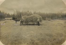
Haying at Broadview
https://search.heritageburnaby.ca/link/archivedescription39551
- Repository
- City of Burnaby Archives
- Date
- 1906
- Collection/Fonds
- Peers Family and Hill Family fonds
- Description Level
- Item
- Physical Description
- 1 photograph : b&w ; 11 x 16 cm on page 21.5 x 28 cm (pasted in album)
- Scope and Content
- Photograph of farmers in the field gathering hay with horse and wagons. In the middle of the photograph three men pose with a horse and hay wagon. The man on the right (with white shirt) is Bernard Hill. The bearded man may be Malcolm Nicholson (from whom Claude Hill bought the land to build his h…
- Repository
- City of Burnaby Archives
- Date
- 1906
- Collection/Fonds
- Peers Family and Hill Family fonds
- Physical Description
- 1 photograph : b&w ; 11 x 16 cm on page 21.5 x 28 cm (pasted in album)
- Description Level
- Item
- Record No.
- 477-870
- Access Restriction
- No restrictions
- Reproduction Restriction
- No known restrictions
- Accession Number
- 2007-12
- Scope and Content
- Photograph of farmers in the field gathering hay with horse and wagons. In the middle of the photograph three men pose with a horse and hay wagon. The man on the right (with white shirt) is Bernard Hill. The bearded man may be Malcolm Nicholson (from whom Claude Hill bought the land to build his home, Broadview). The other man is unidentified. This photograph was taken on the Broadview site, looking south, roughly at the corner of Sperling Avenue and Rugby Avenue, towards Buckingham Avenue.
- Names
- Hill, Bernard R.
- Media Type
- Photograph
- Notes
- Title based on contents of photograph
- Geographic Access
- Buckingham Avenue
- Sperling Avenue
- Rugby Street
- Historic Neighbourhood
- Burnaby Lake (Historic Neighbourhood)
- Planning Study Area
- Morley-Buckingham Area
Images

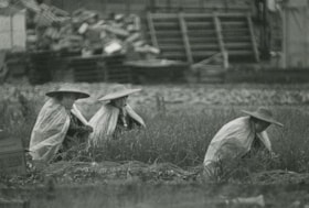
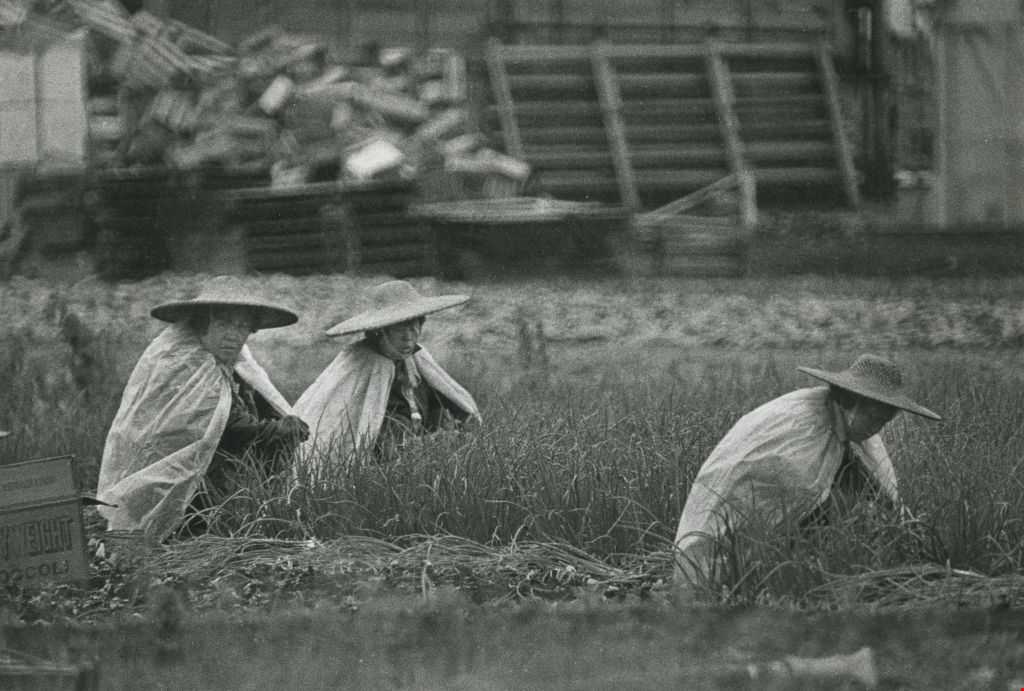
Farming in the rain
https://search.heritageburnaby.ca/link/archivedescription45325
- Repository
- City of Burnaby Archives
- Date
- July 13, 1981
- Collection/Fonds
- Columbian Newspaper collection
- Description Level
- Item
- Physical Description
- 1 photograph : b&w ; 15.5 x 22.5 cm
- Scope and Content
- Photograph of three farmers wearing straw hats and plastic shawls working in the rain in an onion field on the Burnaby flats near Meadow Street (now named Meadow Avenue).
- Repository
- City of Burnaby Archives
- Date
- July 13, 1981
- Collection/Fonds
- Columbian Newspaper collection
- Physical Description
- 1 photograph : b&w ; 15.5 x 22.5 cm
- Description Level
- Item
- Record No.
- 480-220
- Access Restriction
- No restrictions
- Reproduction Restriction
- No restrictions
- Accession Number
- 2003-02
- Scope and Content
- Photograph of three farmers wearing straw hats and plastic shawls working in the rain in an onion field on the Burnaby flats near Meadow Street (now named Meadow Avenue).
- Subjects
- Occupations - Farmers
- Media Type
- Photograph
- Photographer
- Battistoni, Peter
- Notes
- Title based on contents of photograph
- Newspaper clipping on verso of photograph reads: "WET WORK... Plastic sheets and broad straw hats protect field workers from the cool, wet elements at a farm on the Burnaby flats near Meadow Street this week. More seasonal weather, however, including rising temperatures and clearly [sic] skies, promises that life in the onion fields will be more tolerable, at least for the next little while."
- Geographic Access
- Meadow Avenue
- Historic Neighbourhood
- Fraser Arm (Historic Neighbourhood)
- Planning Study Area
- Big Bend Area
Images