Narrow Results By
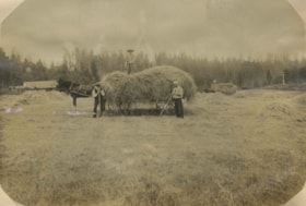
Haying at Broadview
https://search.heritageburnaby.ca/link/archivedescription39551
- Repository
- City of Burnaby Archives
- Date
- 1906
- Collection/Fonds
- Peers Family and Hill Family fonds
- Description Level
- Item
- Physical Description
- 1 photograph : b&w ; 11 x 16 cm on page 21.5 x 28 cm (pasted in album)
- Scope and Content
- Photograph of farmers in the field gathering hay with horse and wagons. In the middle of the photograph three men pose with a horse and hay wagon. The man on the right (with white shirt) is Bernard Hill. The bearded man may be Malcolm Nicholson (from whom Claude Hill bought the land to build his h…
- Repository
- City of Burnaby Archives
- Date
- 1906
- Collection/Fonds
- Peers Family and Hill Family fonds
- Physical Description
- 1 photograph : b&w ; 11 x 16 cm on page 21.5 x 28 cm (pasted in album)
- Description Level
- Item
- Record No.
- 477-870
- Access Restriction
- No restrictions
- Reproduction Restriction
- No known restrictions
- Accession Number
- 2007-12
- Scope and Content
- Photograph of farmers in the field gathering hay with horse and wagons. In the middle of the photograph three men pose with a horse and hay wagon. The man on the right (with white shirt) is Bernard Hill. The bearded man may be Malcolm Nicholson (from whom Claude Hill bought the land to build his home, Broadview). The other man is unidentified. This photograph was taken on the Broadview site, looking south, roughly at the corner of Sperling Avenue and Rugby Avenue, towards Buckingham Avenue.
- Names
- Hill, Bernard R.
- Media Type
- Photograph
- Notes
- Title based on contents of photograph
- Geographic Access
- Buckingham Avenue
- Sperling Avenue
- Rugby Street
- Historic Neighbourhood
- Burnaby Lake (Historic Neighbourhood)
- Planning Study Area
- Morley-Buckingham Area
Images

![Jesse Love's Fruit Farm, Burnaby, BC, [1900] thumbnail](/media/hpo/_Data/_Archives_Images/_Unrestricted/001/022-004.jpg?width=280)
Jesse Love's Fruit Farm, Burnaby, BC
https://search.heritageburnaby.ca/link/archivedescription34501
- Repository
- City of Burnaby Archives
- Date
- [1900]
- Collection/Fonds
- Burnaby Historical Society fonds
- Description Level
- Item
- Physical Description
- 1 photograph : sepia ; 12.8 x 17.8 cm mounted on cardboard 14.7 x 19.8 cm
- Scope and Content
- Photograph of members of the Love family kneeling in a strawberry field. Left to right: Jesse Love (father), Leonard, Phoebe, Martha, Minnie, Martha Love (mother), and Sarah. The small building at the extreme left of the picture was George Love's (oldest of the Love's children) first sash and doo…
- Repository
- City of Burnaby Archives
- Date
- [1900]
- Collection/Fonds
- Burnaby Historical Society fonds
- Subseries
- Photographs subseries
- Physical Description
- 1 photograph : sepia ; 12.8 x 17.8 cm mounted on cardboard 14.7 x 19.8 cm
- Description Level
- Item
- Record No.
- 022-004
- Access Restriction
- No restrictions
- Reproduction Restriction
- No known restrictions
- Accession Number
- BHS2007-04
- Scope and Content
- Photograph of members of the Love family kneeling in a strawberry field. Left to right: Jesse Love (father), Leonard, Phoebe, Martha, Minnie, Martha Love (mother), and Sarah. The small building at the extreme left of the picture was George Love's (oldest of the Love's children) first sash and door outlet. He later built Love's Sash and Door Factory on the south side of Edmonds Street just west of 6th Street. The original farm was located in East Burnaby, on Cumberland Road. In 1988, this house was moved to the site of the Burnaby Village Museum at Deer Lake Avenue.
- Names
- Love, Jesse, 1849-1928
- Love, Leonard
- Brandrith, Martha Dorothy “Dot” Love
- Love, Martha Leonard, 1858-1920
- McKenzie, Edith Minnie Love
- Feedham, Phoebe Leonard Love
- Parker, Sarah Maria Love
- Media Type
- Photograph
- Photographer
- Cooksley, William Thomas
- Notes
- Annotation bottom of the photograph reads, "Jesse Love's Fruit Farm, Burnaby, BC"
- Geographic Access
- Cumberland Street
- Street Address
- 6501 Deer Lake Avenue
- Historic Neighbourhood
- East Burnaby (Historic Neighbourhood)
- Planning Study Area
- Cariboo-Armstrong Area
Images
![Jesse Love's Fruit Farm, Burnaby, BC, [1900] thumbnail](/media/hpo/_Data/_Archives_Images/_Unrestricted/001/022-004.jpg)