
Altar at St. Andrew's Anglican Church
https://search.heritageburnaby.ca/link/archivedescription38248
- Repository
- City of Burnaby Archives
- Date
- 1924
- Collection/Fonds
- Burnaby Historical Society fonds
- Description Level
- Item
- Physical Description
- 1 photograph : b&w ; 9 x 12.5 cm
- Scope and Content
- Photograph of the altar at St. Andrew's Anglican Church, prepared for Easter Sunday.
- Repository
- City of Burnaby Archives
- Date
- 1924
- Collection/Fonds
- Burnaby Historical Society fonds
- Subseries
- Margaret McCallum subseries
- Physical Description
- 1 photograph : b&w ; 9 x 12.5 cm
- Description Level
- Item
- Record No.
- 375-009
- Access Restriction
- No restrictions
- Reproduction Restriction
- No known restrictions
- Accession Number
- BHS1986-42
- Scope and Content
- Photograph of the altar at St. Andrew's Anglican Church, prepared for Easter Sunday.
- Media Type
- Photograph
- Notes
- Title based on contents of photograph.
- Geographic Access
- Gilmore Avenue
- Norfolk Street
- Historic Neighbourhood
- Broadview (Historic Neighbourhood)
- Planning Study Area
- Cascade-Schou Area
Images

Estimate re Pipe Line on Norfolk Street
https://search.heritageburnaby.ca/link/councilreport67389
- Repository
- City of Burnaby Archives
- Report ID
- 58276
- Meeting Date
- 6-Aug-1928
- Format
- Council - Committee Report
- Collection/Fonds
- City Council and Office of the City Clerk fonds
- Repository
- City of Burnaby Archives
- Report ID
- 58276
- Meeting Date
- 6-Aug-1928
- Format
- Council - Committee Report
- Collection/Fonds
- City Council and Office of the City Clerk fonds
Documents
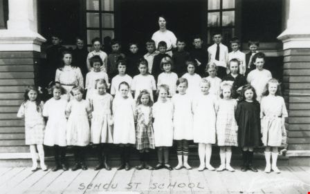
![School Class, [1920] (date of original), copied 1992 thumbnail](/media/hpo/_Data/_Archives_Images/_Unrestricted/315/315-113.jpg?width=280)
School Class
https://search.heritageburnaby.ca/link/archivedescription36758
- Repository
- City of Burnaby Archives
- Date
- [1920] (date of original), copied 1992
- Collection/Fonds
- Burnaby Historical Society fonds
- Description Level
- Item
- Physical Description
- 1 photograph : b&w ; 8.7 x 12.6 cm print
- Scope and Content
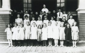
- Photograph of a school class, probably Schou Street School. Some of the children are in costume.
- Repository
- City of Burnaby Archives
- Date
- [1920] (date of original), copied 1992
- Collection/Fonds
- Burnaby Historical Society fonds
- Subseries
- Burnaby Centennial Anthology subseries
- Physical Description
- 1 photograph : b&w ; 8.7 x 12.6 cm print
- Description Level
- Item
- Record No.
- 315-113
- Access Restriction
- No restrictions
- Reproduction Restriction
- No known restrictions
- Accession Number
- BHS1994-04
- Scope and Content
- Photograph of a school class, probably Schou Street School. Some of the children are in costume.
- Subjects
- Clothing - Costumes
- Names
- Schou Street School
- Media Type
- Photograph
- Notes
- Title based on contents of photograph
- Geographic Access
- Gilmore Avenue
- Grandview Highway
- Canada Way
- Street Address
- 4054 Norfolk Street
- Historic Neighbourhood
- Broadview (Historic Neighbourhood)
- Planning Study Area
- Cascade-Schou Area
Images
![School Class, [1920] (date of original), copied 1992 thumbnail](/media/hpo/_Data/_Archives_Images/_Unrestricted/315/315-113.jpg)

Schou Street School
https://search.heritageburnaby.ca/link/archivedescription37032
- Repository
- City of Burnaby Archives
- Date
- 1924 (date of original), copied 1992
- Collection/Fonds
- Burnaby Historical Society fonds
- Description Level
- Item
- Physical Description
- 1 photograph : b&w ; 10.1 x 14.9 cm print
- Scope and Content
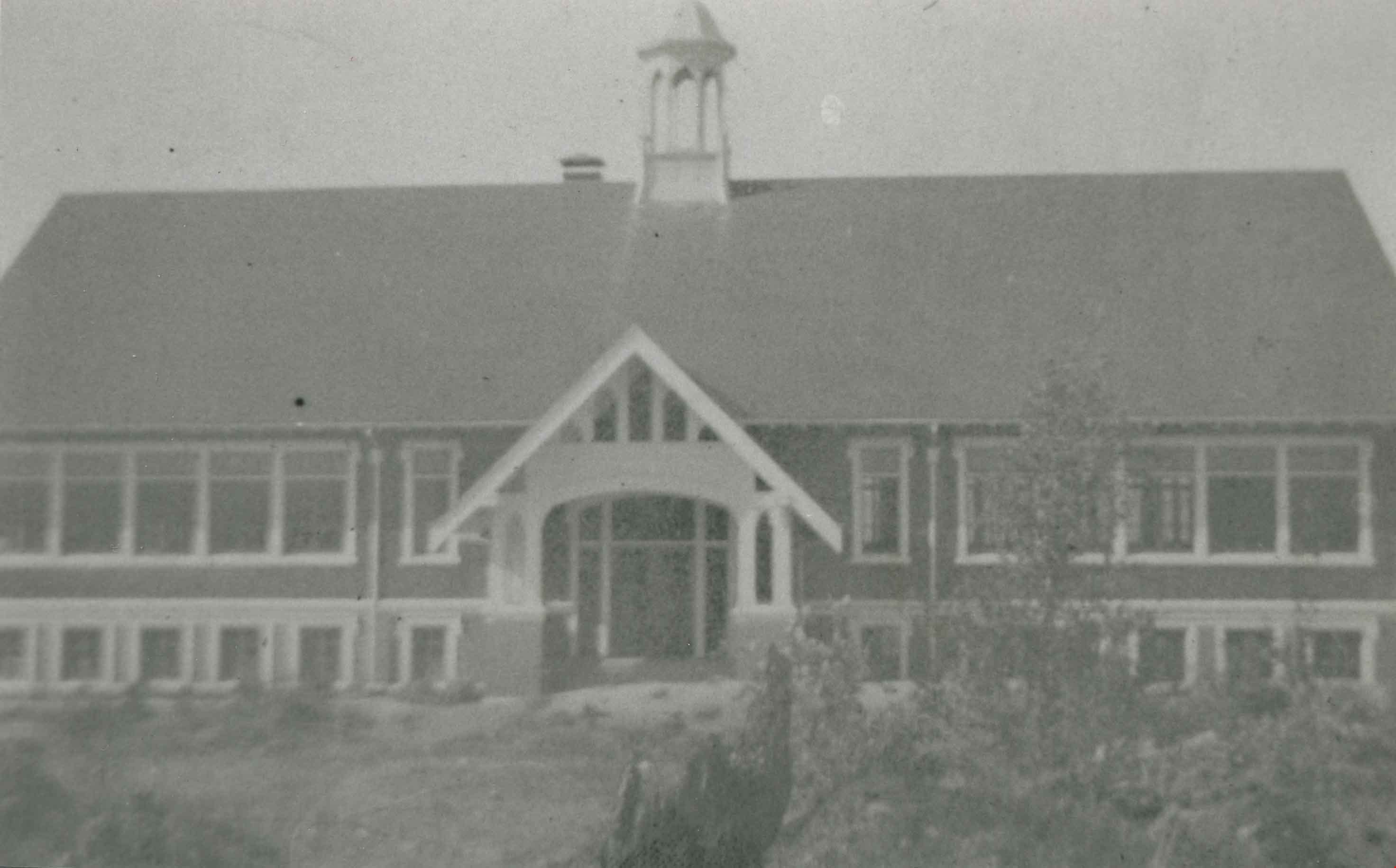
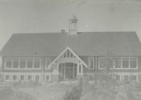
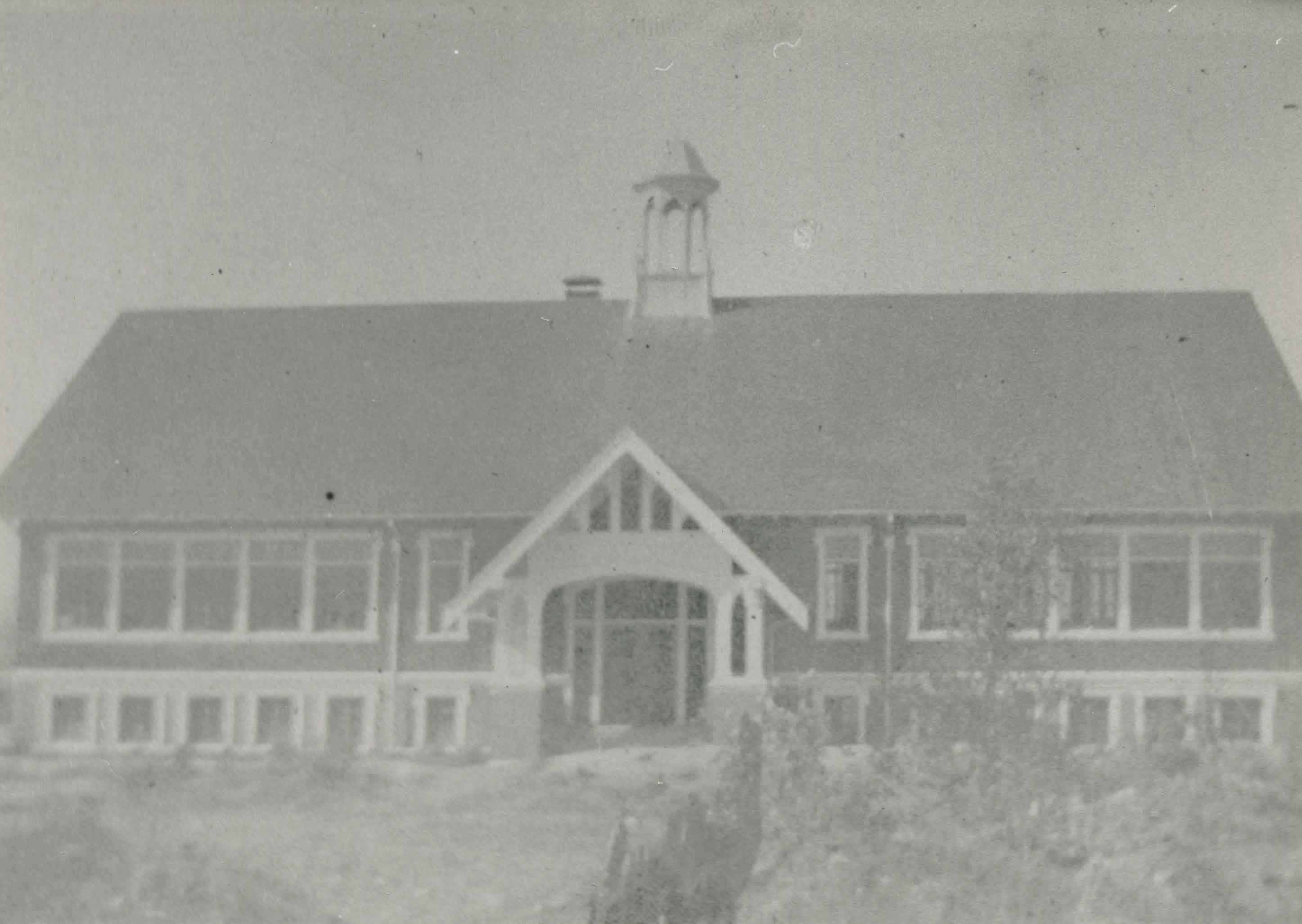
- Photograph of the exterior of Schou Street School.
- Repository
- City of Burnaby Archives
- Date
- 1924 (date of original), copied 1992
- Collection/Fonds
- Burnaby Historical Society fonds
- Subseries
- Burnaby Centennial Anthology subseries
- Physical Description
- 1 photograph : b&w ; 10.1 x 14.9 cm print
- Description Level
- Item
- Record No.
- 315-495
- Access Restriction
- No restrictions
- Reproduction Restriction
- No known restrictions
- Accession Number
- BHS1994-04
- Scope and Content
- Photograph of the exterior of Schou Street School.
- Subjects
- Buildings - Schools
- Names
- Schou Street School
- Media Type
- Photograph
- Notes
- Title based on contents of photograph
- Geographic Access
- Grandview Highway
- Gilmore Avenue
- Canada Way
- Street Address
- 4054 Norfolk Street
- Historic Neighbourhood
- Broadview (Historic Neighbourhood)
- Planning Study Area
- Cascade-Schou Area
Images
Schou Street School
https://search.heritageburnaby.ca/link/archivedescription38250
- Repository
- City of Burnaby Archives
- Date
- 1924
- Collection/Fonds
- Burnaby Historical Society fonds
- Description Level
- Item
- Physical Description
- 1 photograph : b&w ; 9 x 12.5 cm
- Scope and Content
- Photograph of the Schou Street School.
- Repository
- City of Burnaby Archives
- Date
- 1924
- Collection/Fonds
- Burnaby Historical Society fonds
- Subseries
- Margaret McCallum subseries
- Physical Description
- 1 photograph : b&w ; 9 x 12.5 cm
- Description Level
- Item
- Record No.
- 375-011
- Access Restriction
- No restrictions
- Reproduction Restriction
- No known restrictions
- Accession Number
- BHS1986-42
- Scope and Content
- Photograph of the Schou Street School.
- Subjects
- Buildings - Schools
- Names
- Schou Street School
- Media Type
- Photograph
- Notes
- Title based on contents of photograph.
- Geographic Access
- Canada Way
- Street Address
- 4054 Norfolk Street
- Historic Neighbourhood
- Broadview (Historic Neighbourhood)
- Planning Study Area
- Cascade-Schou Area
Images
Schou Street School class
https://search.heritageburnaby.ca/link/archivedescription37024
- Repository
- City of Burnaby Archives
- Date
- 1922 (date of original), copied 1992
- Collection/Fonds
- Burnaby Historical Society fonds
- Description Level
- Item
- Physical Description
- 1 photograph : b&w ; 7.7 x 12.0 cm print
- Scope and Content
- Photograph of a Schou Street School class. Identified: (behind children) Miss Chute (teacher).
- Repository
- City of Burnaby Archives
- Date
- 1922 (date of original), copied 1992
- Collection/Fonds
- Burnaby Historical Society fonds
- Subseries
- Burnaby Centennial Anthology subseries
- Physical Description
- 1 photograph : b&w ; 7.7 x 12.0 cm print
- Description Level
- Item
- Record No.
- 315-487
- Access Restriction
- No restrictions
- Reproduction Restriction
- No known restrictions
- Accession Number
- BHS1994-04
- Scope and Content
- Photograph of a Schou Street School class. Identified: (behind children) Miss Chute (teacher).
- Subjects
- Occupations - Teachers
- Names
- Schou Street School
- Media Type
- Photograph
- Geographic Access
- Grandview Highway
- Gilmore Avenue
- Canada Way
- Street Address
- 4054 Norfolk Street
- Historic Neighbourhood
- Broadview (Historic Neighbourhood)
- Planning Study Area
- Cascade-Schou Area
Images
![Schou Street School students, [1920] (date of original), copied 1992 thumbnail](/media/hpo/_Data/_Archives_Images/_Unrestricted/315/315-115.jpg?width=280)
Schou Street School students
https://search.heritageburnaby.ca/link/archivedescription36760
- Repository
- City of Burnaby Archives
- Date
- [1920] (date of original), copied 1992
- Collection/Fonds
- Burnaby Historical Society fonds
- Description Level
- Item
- Physical Description
- 1 photograph : b&w ; 8.7 x 12.6 cm print
- Scope and Content
- Photograph of Schou Street School students.
- Repository
- City of Burnaby Archives
- Date
- [1920] (date of original), copied 1992
- Collection/Fonds
- Burnaby Historical Society fonds
- Subseries
- Burnaby Centennial Anthology subseries
- Physical Description
- 1 photograph : b&w ; 8.7 x 12.6 cm print
- Description Level
- Item
- Record No.
- 315-115
- Access Restriction
- No restrictions
- Reproduction Restriction
- No known restrictions
- Accession Number
- BHS1994-04
- Scope and Content
- Photograph of Schou Street School students.
- Names
- Schou Street School
- Media Type
- Photograph
- Notes
- Title based on contents of photograph
- Photographer identifed as "Bridgman"
- Geographic Access
- Gilmore Avenue
- Grandview Highway
- Canada Way
- Street Address
- 4054 Norfolk Street
- Historic Neighbourhood
- Broadview (Historic Neighbourhood)
- Planning Study Area
- Cascade-Schou Area
Images
![Schou Street School students, [1920] (date of original), copied 1992 thumbnail](/media/hpo/_Data/_Archives_Images/_Unrestricted/315/315-115.jpg)
Small family fonds
https://search.heritageburnaby.ca/link/archivedescription91819
- Repository
- City of Burnaby Archives
- Date
- 1922-2016
- Collection/Fonds
- Small family fonds
- Description Level
- Fonds
- Physical Description
- 75 photographs : b&w & col. + 1 plan
- Scope and Content
- Fonds consists of photographs documenting the transformation of the Burnaby Lake area of Burnaby, B.C. from semi-rural in the 1920s to urbanized in 2016. Photographs depict the land and houses located on the corner of Douglas Road and Dominion Street as the property was rezoned and its density quad…
- Repository
- City of Burnaby Archives
- Date
- 1922-2016
- Collection/Fonds
- Small family fonds
- Physical Description
- 75 photographs : b&w & col. + 1 plan
- Description Level
- Fonds
- Access Restriction
- Open access
- Reproduction Restriction
- May be restricted by third party rights
- Accession Number
- 2017-01
- Scope and Content
- Fonds consists of photographs documenting the transformation of the Burnaby Lake area of Burnaby, B.C. from semi-rural in the 1920s to urbanized in 2016. Photographs depict the land and houses located on the corner of Douglas Road and Dominion Street as the property was rezoned and its density quadrupled. Fonds also includes photographs of the Small family house being moved to 5496 Dominion Street and the original landscape plan for 5118 Douglas Road.
- History
- In 1915, John W. Roberts and his wife Mary Allen Roberts moved from the United States to Canada along with their daughter, Lauretta. On first moving to Canada, the family lived in a rented house in Vancouver and John worked as a movie projectionist in the city. The couple had three more children, all sons: John A., Edward, and Roland. Circa 1921, John purchased a large parcel of land at the corner of Douglas Road and Dominion Street in Burnaby. This parcel encompassed the equivalent of at least six 66-foot lots along the south side of Dominion Street and the same along the north side of Norfolk Street. On their property, a barn and small living quarters were built. The family moved in, raising goats and growing potatoes to supplement their income. They also planted cherry, apple, and pear trees; hazelnut and walnut trees; raspberries; and a large vegetable garden, the fruits of which Mary preserved for year-round use. At this time, agricultural activities were common for families in the area: the Roberts' neighbours kept chickens for personal use and for selling eggs; grew mushrooms for commercial sale; and sold manure from an old buckboard drawn by Clydesdale horses. John built a new house in the middle of the Roberts’ lots on the southwest corner of Douglas Road and Dominion Street. The house faced Douglas Road and overlooked a large, well-landscaped front yard to the east and a full-sized, clay tennis court to the north. The family moved into this new house in 1925. When the Roberts ceased raising goats, the barn and original living quarters were reduced to a double-car garage with storage space plus a sawdust-insulated “root cellar”. John also built a house on the northwest corner of the lot at Douglas Road and Dominion Street (3093 Douglas Road), which was purchased by the Hardy family. In 1957, part of this property (3071 Douglas Road) was sold to the Brocklebanks who built a house and lived there. In addition, John built a house at the northwest corner of Douglas Road and Norfolk Street (5106 Douglas Road). The original purchaser of this house is unknown, but in 1949, it was bought by the Meyers family. In 1952 or 1953, the Meyers sold part of this property and the Manahans built a house on it, facing Douglas Road. Several other lots that John owned were also sold off over the years. By the 1950s, John owned only five 66-foot lots from Douglas Road west, along the south side Dominion Street. In 1954, John sold the lot furthest from Douglas Road (5486 Dominion Street) to a builder who built a “ranch-style” house and put it up for sale. John retired from his career as a movie projectionist in the 1950s. He, Mary, and Lauretta retained their US citizenship all their lives, although they never returned to the USA except for brief visits. John A., Edward, and Roland who, as children of US citizens, also had US citizenship, eventually moved to the US, where they remained for the rest of their lives. In 1945, Lauretta married Frederick Small. The couple lived in a rented house in Vancouver for a few years before moving in with John and Mary in Burnaby. The couple had four children: Elizabeth, Kathryn, Charles, and Martin. In 1955, Frederick purchased the rancher at 5486 Dominion Street and the family moved in. The Small children grew up enjoying the freedom of having their grandparent’s large property in addition to their parent’s yard to play in. The back lane that ran between Dominion Street and Norfolk Street was filled with trees and bushes, creating a narrow bit of “forest” to explore. In 1957, John died. Mary died in 1969, as did Frederick. Lauretta was executor for her mother’s and husband’s estates. After much consideration, she decided to sell the house at 5486 Dominion Street and move back into her childhood home. By doing so, she was able to settle her mother’s estate to the satisfaction of her brothers. Elizabeth married and moved away. Over the next few years, the “Roberts” house was home to Lauretta, Kathryn, Charles, and Martin, with the three grown children moving in and out several times during the 1970s. In 1981, Lauretta died. Her children discussed at length how to divide up the property, which consisted of four 66-foot lots, according to her will. None of her children wanted to see the old family house destroyed but the house straddled two lots. They finally decided that if one of them wanted to pay to move the house to sit on one of the lots, the “value” of the house would not enter into the settlement of the estate. Kathryn chose to do this. In 1982, the old house was moved to 5496 Dominion Street and Kathryn continued to live in it. Martin died in 1982. Elizabeth and Charles each inherited one lot and the last lot, which would have gone to Martin, was sold, the funds divided equally between Elizabeth, Kathryn, and Charles. The three lots between 5496 Dominion Street and Douglas Road were subdivided into 33-foot lots and six new houses were built. In 1993, the Meyers property and the Manahan property were subdivided into 33-foot lots facing Norfolk Street and the old houses were torn down and four new houses were built.
- Media Type
- Photograph
- Technical Drawing
- Creator
- Small family

St. Andrews Anglican Church
https://search.heritageburnaby.ca/link/archivedescription38247
- Repository
- City of Burnaby Archives
- Date
- 1924
- Collection/Fonds
- Burnaby Historical Society fonds
- Description Level
- Item
- Physical Description
- 1 photograph : b&w ; 9 x 12.4 cm
- Scope and Content
- Photograph of the exterior of St. Andrew's Anglican Church built primarily by volunteer labour.
- Repository
- City of Burnaby Archives
- Date
- 1924
- Collection/Fonds
- Burnaby Historical Society fonds
- Subseries
- Margaret McCallum subseries
- Physical Description
- 1 photograph : b&w ; 9 x 12.4 cm
- Description Level
- Item
- Record No.
- 375-008
- Access Restriction
- No restrictions
- Reproduction Restriction
- No known restrictions
- Accession Number
- BHS1986-42
- Scope and Content
- Photograph of the exterior of St. Andrew's Anglican Church built primarily by volunteer labour.
- Subjects
- Buildings - Religious - Churches
- Media Type
- Photograph
- Notes
- Title based on contents of photograph
- Geographic Access
- Norfolk Street
- Gilmore Avenue
- Historic Neighbourhood
- Broadview (Historic Neighbourhood)
- Planning Study Area
- Cascade-Schou Area
Images
