Narrow Results By
Decade
- 2020s 15
- 2010s 28
- 2000s 116
- 1990s 140
- 1980s 98
- 1970s 150
- 1960s 125
- 1950s 177
- 1940s 143
- 1930s 193
- 1920s 389
- 1910s 305
- 1900s 171
- 1890s 98
- 1880s 17
- 1870s 10
- 1860s
- 1850s 6
- 1840s 1
- 1810s 1
- 1800s 1
- 1790s 1
- 1780s 1
- 1770s 1
- 1760s 1
- 1750s 1
- 1740s 1
- 1730s 1
- 1720s 1
- 1710s 1
- 1700s 1
- 1690s 1
- 1680s 1
- 1670s 1
- 1660s 1
- 1650s 1
- 1640s 1
- 1630s 1
- 1620s 1
- 1610s 1
- 1600s 1
- 1590s 1
- 1580s 1
- 1570s 1
- 1560s 1
- 1550s 1
- 1540s 1
- 1530s 1
- 1520s 1
- 1510s 1
- 1500s 1
- 1490s 1
- 1480s 1
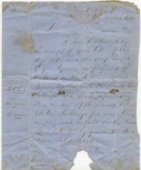
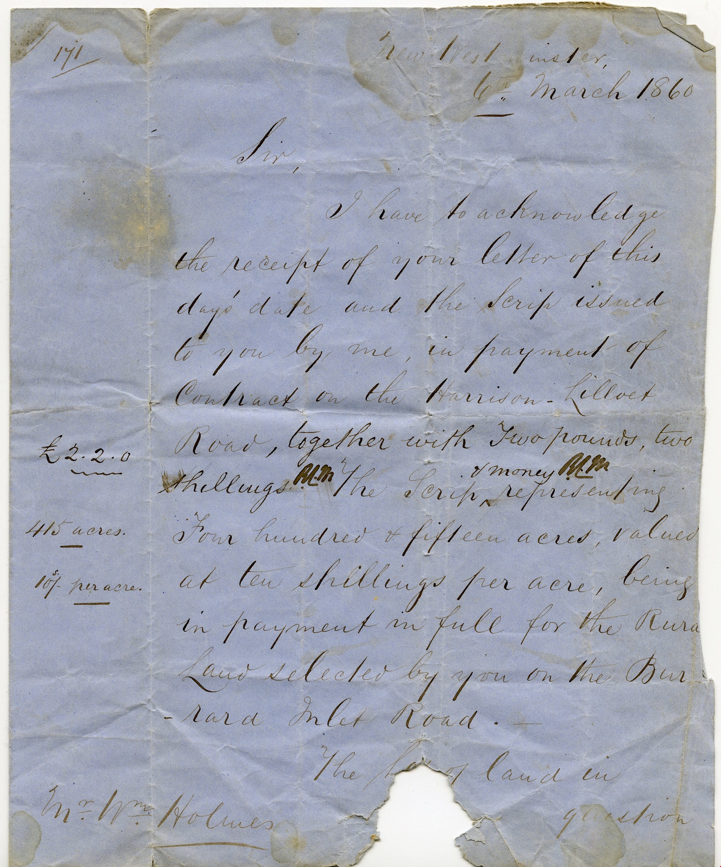
Letter re payment of Lot No. 1, Group 1, New Westminster District
https://search.heritageburnaby.ca/link/museumdescription10404
- Repository
- Burnaby Village Museum
- Date
- 6 Mar. 1860
- Collection/Fonds
- William Holmes fonds
- Description Level
- Item
- Physical Description
- 1 p. textual record ; folded
- Scope and Content
- Item consists of a handwritten letter on blue paper dated "6th March 1860". The letter is addressed to Mr. Wm. Holmes from Colonel Moody regarding payment of a contract on Harrison Lilloet Road and two pounds two shillings scrip payment for land on Burrard Inlet Road..."Lot No. 1, Group 1, Rural La…
- Repository
- Burnaby Village Museum
- Collection/Fonds
- William Holmes fonds
- Description Level
- Item
- Physical Description
- 1 p. textual record ; folded
- Scope and Content
- Item consists of a handwritten letter on blue paper dated "6th March 1860". The letter is addressed to Mr. Wm. Holmes from Colonel Moody regarding payment of a contract on Harrison Lilloet Road and two pounds two shillings scrip payment for land on Burrard Inlet Road..."Lot No. 1, Group 1, Rural Land, New Westminster District..."
- Accession Code
- BV997.50.3
- Access Restriction
- No restrictions
- Reproduction Restriction
- No known restrictions
- Date
- 6 Mar. 1860
- Media Type
- Textual Record
- Scan Resolution
- 300
- Scan Date
- 06-May-2019
- Notes
- Title based on contents of item
Images

![Survey and Subdivision plans in New Westminster District Group 1 – Burnaby
, [1861]-[1910] thumbnail](/media/hpo/_Data/_BVM_Cartographic_Material/1977/1977_0093_0019a_001.jpg?width=280)
Survey and Subdivision plans in New Westminster District Group 1 – Burnaby
https://search.heritageburnaby.ca/link/museumdescription6988
- Repository
- Burnaby Village Museum
- Date
- [1861]-[1910]
- Collection/Fonds
- Burnaby Village Museum Map collection
- Description Level
- File
- Physical Description
- 14 plans : 3 plans : black ink on paper hand col. + 7 plans : black ink on paper + 4 plans : graphite on paper mounted on 2 sides of cardboard 76 x 102 cm
- Scope and Content
- Item consists of a large board of four New Westminster District Gp 1 - subdivision plans mounted on one side and ten New Westminster District Gp 1 - subdivision plans mounted on the other side. Side A: 1. "Plan /of / Lots 166A, 166 and 167 /, Gr.1, N.W.D. / Showing Misconstructed Roads in Gree…
- Repository
- Burnaby Village Museum
- Collection/Fonds
- Burnaby Village Museum Map collection
- Description Level
- File
- Physical Description
- 14 plans : 3 plans : black ink on paper hand col. + 7 plans : black ink on paper + 4 plans : graphite on paper mounted on 2 sides of cardboard 76 x 102 cm
- Material Details
- Scales [between 1:2376 and 1:7920]
- Index number on edge of board reads: "19"
- Scope and Content
- Item consists of a large board of four New Westminster District Gp 1 - subdivision plans mounted on one side and ten New Westminster District Gp 1 - subdivision plans mounted on the other side. Side A: 1. "Plan /of / Lots 166A, 166 and 167 /, Gr.1, N.W.D. / Showing Misconstructed Roads in Green / 5 chs = 1 in.". (plan is drawn in black ink and hand coloured in red, green and orange ink). A section in the centre of the plan is coloured in red ink and identified as "C.S. Richmond" running from the North Arm of Fraser River to Wiggins Road and divided by "New Wiggins Rd. (as gazetted)" (coloured in orange ink) and two"Constructed Road(s)" (coloured in green ink). Plan is initialed by: "RB" [sic] (in blue pencil crayon) 2. Plan of / Subdivision of / Lot 166 / Group One / New Westminster District / Scale 4 chs = 1 in. / Map No 524". Plan is drawn in graphite and signed by "Surrig [sic] Welhams [sic] / P.L.S." Plan is initialed by: "RB" [sic] (in blue pencil crayon) 3. Plan of "Survey / of Highway / For / Burnaby Council / in / Lots 13 _14 / Group One / Scale 4 chs = 1 in." Signed by "Albert J. Hill, P.L.S." Caribou Street and Caribou Road run through the centre of the plan. Plan is stamped: "Albert J. Hill, Civil Engineer / and / Provincial Land Surveyor, / New Westminster, / B.C.". Plan is initialed by: "RB" [sic] (in blue pencil crayon) 4. A Plan of Lots 166A, 166 and 167, Group One, New Westminster District (drawn in graphite). A section in the centre of the plan is identified as "C.S. Richmond" running from the North Arm of Fraser River and divided by "New Wiggins Rd. (as gazetted)" and two "Constructed Road(s)". Plan is initialed by: "RB" [sic] (in blue pencil crayon) Side B: 1. Small plan drawn in black ink (no title) identifying lots north of the "North Arm" of the Fraser River. Lots identified include: Lot 99, Lot 98, Lot 157, Lot 158, Lot 163, Lot 162, Lot 159, Lot 163, Lot 162, Lot 165, Lot 166A, Lot 155B, Lot 155A and Lot 159. "Scale 40 chains to one inch" . Plan is initialed by: "RB" [sic] (in blue pencil crayon) (Geographic location: Burnaby) 2. Small plan drawn in black ink (no title) identifying lots north of the North Arm of the Fraser River as "Lots 155, 155A, 155B, 155C, 162, 163, 164, 165, 166A and 167". Plan is initialed by: "RB" [sic] (in blue pencil crayon) (Geographic location: Burnaby) 3. Small plan drawn in black ink (no title) which identifies "Lot 151 / Reserve/ for / Race Course"; "Reserve / 64 A / L. 152 G.1"; and other Lots: 32, 33, 34, 35, 36, 38, 39. The plan is signed "Surveyor G.Turn [sic] July / 61 / from Vol 40 R.L. notes [sic]" Plan is stamped: "Albert J. Hill, Civil Engineer / and / Provincial Land Surveyor, / New Westminster, / B.C." Plan is initialed by: "RB" [sic] (in blue pencil crayon) (Geographic location: Burnaby) 4. Small plan drawn in black in with faded red colouring on centre lot identified as "Lot 34" running north from "Vancouver Road" . Plan is stamped: "Albert J. Hill, Civil Engineer / and / Provincial Land Surveyor, / New Westminster, / B.C." Plan is initialed by: "RB" [sic] (in blue pencil crayon) (Geographic location: Burnaby) 5. Plan drawn in graphite and identified as "Lot 98, Gr.1," along with the intials "RB" [sic] (both are handwritten in blue crayon pencil on top of plan) The B.C.E.Railway is identified running through the plan along with Jubilee Road and Royal Oak Road. The plan is signed with the name "Wm. Murray" and the Plan is stamped: "Albert J. Hill, Civil Engineer / and / Provincial Land Surveyor, / New Westminster, / B.C.". (Geographic location: Burnaby) 6. Plan drawn in graphite identified as "Port Lot 13, Gr.1" along with the intials "RB" [sic] (both are handwritten in blue crayon pencil on top of plan) Plan is stamped: "Albert J. Hill, Civil Engineer / and / Provincial Land Surveyor, / New Westminster, / B.C.". (Geographic location: Burnaby) 7.Plan drawn in black ink and identified as "Lot 98 G.1" along with the intials "RB" [sic] (both are handwritten in blue crayon pencil on top of plan). A "Road Reservation" is identified running north between "Electric Tramway" and connecting with "Royal Oak Road". Plan is stamped: "Albert J. Hill, Civil Engineer / and / Provincial Land Surveyor, / New Westminster, / B.C." (Geographic location: Burnaby) 8. Plan drawn in black ink and divided into two sections, the upper plan is identified as "Portion / Lots 100 / area / 101, Gr.1" and the lower plan is identified as "Portion L. 3 G. 1" along with the intials "RB" [sic] (these identifiers are handwritten in blue crayon pencil on top of the plan). Portions of Lot 100 and Lot 101 are each divided into 6 sections and the Portion of Lot 3 plan is divided into 24 sections. The plan includes a note in black ink that reads: " Received from Wm Fromme [sic] / from Wm. Trapp / Nov. 28, 1895 / A. J. T...[sic]". (Geographic location: Burnaby) 9. Plan drawn in black ink (no title) identifying soil, buildings and geographic features in southern Burnaby. The plan is bordered by "New Westminster City" (Tenth Avenue and DL 172) to the south east and DL 173 to the south, DL 158 to the west and the B.C.E. Tramway to the north. Plan includes District Lots: 155A, 158, 159, 171, 160, 53 and 95 and identifies soil, marshland and ravines throughout. Plan identifies the following features: a "Team Road" running through Lots 158 and 159 along with "Fair Orchard Soil / Even Surface Throughout / No Ravines", "Gravel and Shingle" (bottom of Lot 158), "North Arm Road" crossing "Byrne Road" and connecting with "Power House Road" which runs north to connect with "Highland Park Station" and the B.C.E. Tramway, "Power Ho" in the northeast corner of DL 160, a "Brook" connected with a "Deep Ravine" running between DL 53, DL 95 and DL 160 along with "Good Soil" and "Fair Orchard Soil" identified nearby in DL 95. Scale is identified as "10 chs = 1 in." Plan is stamped: "Albert J. Hill, Civil Engineer / and / Provincial Land Surveyor, / New Westminster, / B.C." Plan is initialed by: "RB" [sic] (in blue pencil crayon) (Geographic location: Burnaby) 10. Plan drawn in black ink (no title) with Burnaby Lake and Deer Lake at the centre. The plan is bordered by the following District Lots identified as: 117, 118 and 68 to the west, Lots 80, 79 and 85 to the southwest, Lots 11, 13, and 1 (City of New Westminster) to the south east, the North Road boundary to the east and Lots 8, 56, 57, 59, and 136 to the North. The lower right hand corner of the plan has a small inset which reads: "Burnaby Lake" and "Page 19 R.B. Notes". Plan is initialed by: "RB" [sic] (in blue pencil crayon) (Geographic location: Burnaby)
- Creator
- Hill, Albert James
- Accession Code
- HV977.93.19
- Access Restriction
- No restrictions
- Reproduction Restriction
- No known restrictions
- Date
- [1861]-[1910]
- Media Type
- Cartographic Material
- Scan Resolution
- 300
- Scale
- 72
- Notes
- Title based on contents of file
- Scale is measured in chains. (One chain equals 792 inches)
- The term "Lot" can also refer to a "District Lot”
- Some plans are stamped: "Albert J. Hill, Civil Engineer / and / Provincial Land Surveyor, / New Westminster, / B.C." and intialed: "RB" [sic]
Images
![Survey and Subdivision plans in New Westminster District Group 1 – Burnaby
, [1861]-[1910] thumbnail](/media/hpo/_Data/_BVM_Cartographic_Material/1977/1977_0093_0019a_001.jpg)

![Survey and Subdivision plans in New Westminster District Group 1 – Burnaby, Port Moody, [1862-1908] thumbnail](/media/hpo/_Data/_BVM_Cartographic_Material/1977/1977_0093_0026a_001.jpg?width=280)
Survey and Subdivision plans in New Westminster District Group 1 – Burnaby, Port Moody
https://search.heritageburnaby.ca/link/museumdescription6995
- Repository
- Burnaby Village Museum
- Date
- [1862-1908]
- Collection/Fonds
- Burnaby Village Museum Map collection
- Description Level
- File
- Physical Description
- 9 plans : 6 plans : black ink on paper ; 57 x 36.5 cm or smaller + 1 plan : black ink and grahite on paper ; 46.5 x 49 cm + 1 plan : blueprint on paper ; 15.5 x 19.5 cm + cm + 1 plan : graphite on paper ; 25 x 17 cm ; mounted on both sides of board 76 x 102 cm
- Scope and Content
- Item consists of a large board of four New Westminster District subdivision plans mounted on one side and five New Westminster District subdivision plans mounted on the other side. Side A: 1. "Plan / of Subdivision / of a Portion / of / Lot 87 / Group One / New Westminster District / Scale 4 chs…
- Repository
- Burnaby Village Museum
- Collection/Fonds
- Burnaby Village Museum Map collection
- Description Level
- File
- Physical Description
- 9 plans : 6 plans : black ink on paper ; 57 x 36.5 cm or smaller + 1 plan : black ink and grahite on paper ; 46.5 x 49 cm + 1 plan : blueprint on paper ; 15.5 x 19.5 cm + cm + 1 plan : graphite on paper ; 25 x 17 cm ; mounted on both sides of board 76 x 102 cm
- Material Details
- Scales [between 1:792 and 1:3600]
- Index number on edge of board reads: "26"
- Scope and Content
- Item consists of a large board of four New Westminster District subdivision plans mounted on one side and five New Westminster District subdivision plans mounted on the other side. Side A: 1. "Plan / of Subdivision / of a Portion / of / Lot 87 / Group One / New Westminster District / Scale 4 chs = 1 in". Plan is stamped: "Albert J. Hill, Civil Engineer / and / Provincial Land Surveyor, / New Westminster, / B.C." and intialed by: "RB" [sic] (in blue pencil crayon). Names two of the subdivisons of District Lot 87 are identified as, "L.E. Sprott" and "John Ledger". (Geographic location: Burnaby) 2. "Plan of Subdivision / of / Portions of / Lot 136, 131 and Lots 44 and 78 Gr.1 / New Westminster District / Scale 300 ft = 1 inch". Annotation above title reads: "No. 901 / Deposited in Land Registry Office / New Westminster / Aug. 19th 1905 / Charles S. Keith D. Reg." Annotations and signatures at bottom of plan read: "I, William Nelson Draper, / W.H.R. Collister / Charles E. Perkins / E.B. Morgan / make / Surveys / correct / representation / upon / the / Land Registry Act / (sgd) W.N. Draper, P.L.S.". Plan includes a handwritten title: "Lots 136, 131, 44 & 78" and is initialed: "RB" [sic] (in blue pencil crayon) (Geographic location: Burnaby) 3. "Survey / of / a Portion / of / Lot 95, Gr.1 / Scale 1 ch = 1in." Plan is stamped: "Albert J. Hill, Civil Engineer / and / Provincial Land Surveyor, / New Westminster, / B.C." and is initialed : "RB" [sic] (in blue pencil crayon) (Geographic location: Burnaby) 4. Blueprint plan of "Lot 396. Group One." with Scale : 3 chs = 1 in. A two acre portion of District Lot 396 is filled in with red ink." Plan is signed by "Albert J. Hill / B.C.L.S." (Geographic location: Port Moody) Side B: 1. Plan titled "District Lot 92 / Burnaby / Municipality / for sale by / Mahon / McFarland & / Mahon Ltd. / Vancouver, B.C. / Scale : 4 chains to one inch". District Lot 92 is subdivided into 161 lots and identifies roads: Norwich Road, Pole Line Road, Oakland Road, Stanley Road, Burford Road, Dalhousie Road, Brantford Road, Colborne Road, Roberts Road, Vancouver & Westminster Road, B.C. Electric Railway, Gilley Stn. and Burnaby (Power House). The bottom of the plan reads: "G.S. Dawson, P.LS. Vancouver, B.C." (Geographic location: Burnaby) 2. "Plan / of Subdivision / of a Portion / of / Lot 29 / Group 1 / New Westminster District / Scale 2 chs = 1 in". Plan is stamped: "Albert J. Hill, Civil Engineer / and / Provincial Land Surveyor, / New Westminster, / B.C." and is initialed by: "RB" [sic] (in blue pencil crayon) (Geographic location: Burnaby) 3. Small handrawn plan (no title) identifying "Lot 84 / Hydes, Claim" at the centre surrounded by lots and features identified as: "Lot 85", "Lot 93", "Lot 94", "Lot 32", "Lot 82", "Lot 83", "Lot 79", "swamp" and a "Small Lake" (Burnaby Lake). Identifying marks in the right corner of the plan read: "Page 13 / Surveyed by G. Turner / May 62". Plan also includes surveyor's bearing measurements and trails to "Small Lake" (Burnaby Lake). (Geographic location: Burnaby) 4. Untitled plan showing District Lots west of North Road and north of Burnaby Lake including: Lots 2, 4, 6, 8, 15, 10, 56, 148, 57, 58, 40. and Lots 3, 5, 7 east of North Road (Coquitlam). Lots in Burnaby are identifed for timber including: "Heavily Timbered" (Lot 57), " "Some Fir and Cedar" (Lot 40), "Splendid Fir and Cedar" (Lot 143), "Heavy Fir etc" (Lots 143 and 148), " "Fine Cedar" (Lot 15), "Rough Light Timber" (Lot 56). Other features identified at the lower portion of the plan include "Burnaby Lake" and "Brunette River". (Geographic location: Burnaby) 5. Untitled plan drawn in graphite showing sections of District Lot 85 south of Burnaby Lake and north of Hazsard Road. Plan is signed: "Albert J. Hill / B.C.L.S." and dated "12/26/08". Plan is initialed by: "RB" [sic] (in blue pencil crayon) (Geographic location: Burnaby)
- Publisher
- Mahon, McFarland & Mahon Ltd
- Accession Code
- HV977.93.26
- Access Restriction
- No restrictions
- Reproduction Restriction
- No known restrictions
- Date
- [1862-1908]
- Media Type
- Cartographic Material
- Historic Neighbourhood
- Burnaby Lake (Historic Neighbourhood)
- Burquitlam (Historic Neighbourhood)
- Planning Study Area
- Burnaby Lake Area
- Scan Resolution
- 300
- Scale
- 72
- Notes
- Title based on contents of file
- Scale is measured in chains and feet. (One chain equals 792 inches)
- The term "Lot" can also refer to a "District Lot”
Images
![Survey and Subdivision plans in New Westminster District Group 1 – Burnaby, Port Moody, [1862-1908] thumbnail](/media/hpo/_Data/_BVM_Cartographic_Material/1977/1977_0093_0026a_001.jpg)


Douglas Road
https://search.heritageburnaby.ca/link/landmark714
- Repository
- Burnaby Heritage Planning
- Associated Dates
- 1865
- Heritage Value
- Douglas Road was built between 1862-1865 by the Royal Engineers based in New Westminster. Originally known as the Douglas Street Trail, it took its name from Governor James Douglas. In 1926 a new connection was made to reach Grandview Road in Vancouver at Boundary Road. To distinguish this new highway it was renamed the Grandview Highway and it became commonly known as the combined Grandview-Douglas Highway until 1968 when the Burnaby and New Westminister sections were renamed Canada Way, in recognition of Canada's Centennial in 1967. The old part of Douglas Road north of Sprott Street remained intact.
- Historic Neighbourhood
- Burnaby Lake (Historic Neighbourhood)
- Planning Study Area
- Douglas-Gilpin Area
- Street View URL
- Google Maps Street View
Images

![Gilley Brothers Logging team, [1895]. . thumbnail](/media/hpo/_Data/_Archives_Images/_Unrestricted/371/461-003.jpg?width=280)
Vancouver Road (Kingsway)
https://search.heritageburnaby.ca/link/landmark729
- Repository
- Burnaby Heritage Planning
- Associated Dates
- 1860
- Heritage Value
- The street we know as Kingsway is one of the legacies of the Royal Engineers' military defences for New Westminster. The fear of an American attack prompted the construction of the False Creek trail - later known as Vancouver Road and now Kingsway - in 1860 to connect the capital city to the ice-free salt water harbour at English Bay.
- Historic Neighbourhood
- Central Park (Historic Neighbourhood)
- Edmonds (Historic Neighbourhood)
- Planning Study Area
- Maywood Area
- Marlborough Area
- Windsor Area
- Kingsway-Beresford Area
- Stride Avenue Area
- Edmonds Area
Images
![Gilley Brothers Logging team, [1895]. . thumbnail](/media/hpo/_Data/_Archives_Images/_Unrestricted/371/461-003.jpg)
William Holmes fonds
https://search.heritageburnaby.ca/link/museumdescription10416
- Repository
- Burnaby Village Museum
- Date
- [1841]-1994
- Collection/Fonds
- William Holmes fonds
- Description Level
- Fonds
- Physical Description
- 2 photographs (calotype) + 1 photograph : b&w + 6 photographs : col. + 5 p. textual records + 1 newspaper clipping
- Scope and Content
- Fonds consists of photographs pertaining to the William Holmes family, family grave markers in cemetery in Ireland along with original correspondence, land title certificates and a newspaper clipping. Fonds is arranged in series: 1) William Holmes family photographs series 2) William Holmes family…
- Repository
- Burnaby Village Museum
- Collection/Fonds
- William Holmes fonds
- Description Level
- Fonds
- Physical Description
- 2 photographs (calotype) + 1 photograph : b&w + 6 photographs : col. + 5 p. textual records + 1 newspaper clipping
- Scope and Content
- Fonds consists of photographs pertaining to the William Holmes family, family grave markers in cemetery in Ireland along with original correspondence, land title certificates and a newspaper clipping. Fonds is arranged in series: 1) William Holmes family photographs series 2) William Holmes family records series 3) Holmes family cemetery photographs series
- History
- William Holmes was the first non-Indigenous resident of Burnaby and was born in Kilkenny Ireland January 4, 1812. In 1833, at the age of 20 yrs, William Holmes immigrated to Canada from Ireland in with his parents, Joseph and Jane (McCullough) Holmes and ten other family members including two of his married brothers and their wives, two sisters with their husbands and two unmarried brothers. This was the first group of thirteen to leave Ireland and set up homesteads in Canada near the shores of Lake Huron. The family settled on land concessions in Huron County, Ontario about 14 km southeast of Goderich. The area in Huron County was first founded in 1832 by John and Samuel Holmes and the community was known as Holmes Hill before becoming Holmesville [ca. 1850]. In 1837, William Holmes is noted as owning Lot 23, Concession IX, Goderich Twp. Much of the village of Holmesville grew up around the five road concession near the border of his brother’s farm so William decided to open a store. The Holmesville post office opened on March 1, 1855 and William was appointed the first post master which he operated until May 1857. William met and married Mary Richardson in 1841 and the couple had three daughters: Jane (1844-1926) (married Charles Studdert Finlaison in New Westminster in 1863); Anne Maria (Annie) (1846-192?) (married John Gunther Jennings in New Westminster in 1865 and married Robert Johnson in New Westminster in 1877) and Elizabeth (1848-1934) (married Thomas Carrington of Lakes District in 1867). William’s wife, Mary (Richardson) Holmes died in Holmesville sometime between 1848 and 1853. Following the death of his first wife, Mary, William married Charlotte McCullough (McCulloch). The couple had four daughters; Arabella Charlotte Amelia (1854-1943) (married Arthur Robert Green in 1887); Laura (1855-1867); Arabella Henrietta (1857-1929) (married Clark Wesley Gillanders in 1880) and Mary (1863-1864). During the late 1850s, William became aware of the gold rush and opportunities opening up in British Columbia so left for the west coast in 1858 at the age of 46 yrs. In preparation for his move to the west coast of Canada, William obtained a letter of introduction from top government officials of Canada. William Holmes arrived in British Columbia in 1859. Upon arriving, he first worked running pack trains from Harrison Mills to Lillooet. After earning some money, he decided to re-invest it in land. His first pre-emption of land occurred on January 21, 1860 for 160 acres situated on North Road from the Military Camp to Burrard Inlet and distancing 25 chains south of the Brunette River and 20 chains south of the river with the land extending in a westerly direction. On March 17, 1860, Holmes received a Crown Grant for this and other land in the immediate area totalling 415 acres of which was known as Lot No. 1, Group 1, Rural Land, New Westminster District. The balance of land was situated on the east side of the Brunette River – Lot 13, with 344 2/3 acres of which he made an application to purchase on June 26, 1860, and a Crown Grant dated March 16, 1861 covering 86 acres. Holmes also pre-empted land in Port Moody and Pitt Meadows in 1860 and 1861. The name of “Brunette River” is officially attributed to William Holmes who referred to the river as “Brunette” due to it’s dark colour originating from the peat lands above the lake. Following his purchase of property, he sent for his wife Charlotte, their three daughters and her three step daughters (from William’s first marriage). Charlotte and the six children made the long trip to B.C. by ship and rail, crossing the Isthmus of Darien at Panama. They arrived in B.C. in October 1861 and moved into a one room log cabin built by William. The cabin stood on the North Road at the foot of Sapperton, on a bluff overlooking the Brunette River. Eventually the family moved to a larger dwelling but the original cabin remained on the site until the 1890s when it was burned after being used as a sick house. Mr. Holmes was instrumental in organizing the first Orange Lodge in British Columbia. He was a prominent Orangeman who joined the order in 1840 and was the first master in the order of the City of New Westminster when the Lodge No. 1150 was established there. Charlotte Holmes died in New Westminster in 1893 at the age of 70 years and William Holmes died in New Westminster September 11, 1907 at the age of 95 years.
- Responsibility
- Holmes, William
- Accession Code
- HV971.46
- BV997.50
- Date
- [1841]-1994
- Media Type
- Photograph
- Textual Record
- Related Material
- See also: Reference file: Persons - Holmes, William
- Notes
- Title based on contents of fonds
![Burton family home, [1945]. Item no. 216-002 thumbnail](/media/hpo/_Data/_Archives_Images/_Unrestricted/205/216-002.jpg?width=280)
Interview with John Burton by Lynda Maeve Orr - Track 5
https://search.heritageburnaby.ca/link/oralhistory221
- Repository
- City of Burnaby Archives
- Date Range
- 1860-1932
- Length
- 0:08:48
- Summary
- This portion of the interview pertains to John Burton's description of the Linotype machine, as well as the history of his grandfather, John Foley, founder of the Orangeville Sun newspaper.
- Repository
- City of Burnaby Archives
- Summary
- This portion of the interview pertains to John Burton's description of the Linotype machine, as well as the history of his grandfather, John Foley, founder of the Orangeville Sun newspaper.
- Date Range
- 1860-1932
- Photo Info
- Burton family home, [1945]. Item no. 216-002
- Length
- 0:08:48
- Names
- Foley, John
- Scope and Content
- Recording is of an interview with John Burton at his residence in Surrey by Lynda Mauve Orr, August 24, 1989. This interview focuses on the history of newspaper and printing presses in Canada.
- Biographical Notes
- John Burton was born in 1912 in New Westminster. He went to Second Street School, then Edmonds, then Saint Anne's Convent, and St. Louis College and Connaught before graduating from Burnaby South School in 1930. While at High School, John worked at Cowan's Music Store at 716 Columbia Street in New Westminster on Saturdays and after school. John Burton's grandfather John Foley was the founder of the Orangeville Sun newspaper in Orangeville, Ontario, established in 1861. He ran the paper until his death in 1882, when his son, John Foley Jr. took over as editor and publisher at the age of sixteen. Two of his daughters were involved in the newspaper; Margaret Foley was a regular contributor to the paper, and John Burton's mother was a typesetter. When John Burton was a teenager, he went to Orangeville to learn the trade from his uncle. Unfortunately, he was only there eighteen months when his uncle died December 21, 1932. The family was unable to hold on to the business and the paper amalgamated with the Orangeville Banner newspaper in 1933.
- Total Tracks
- 7
- Total Length
- 0:58:44
- Interviewee Name
- Burton, John
- Collection/Fonds
- Burnaby Historical Society fonds
- Subseries
- Oral history subseries
- Media Type
- Sound Recording
- Web Notes
- Interview was digitized in 2010 allowing it to be accessible on Heritage Burnaby. The digitization project was initiated by the Community Heritage Commission with support from City of Burnaby Council and the BC History Digitization Program of the Irving K. Barber Learning Centre, University of British Columbia. It was recognized by the Heritage Society of BC with an award in 2012.
Images
![Burton family home, [1945]. Item no. 216-002 thumbnail](/media/hpo/_Data/_Archives_Images/_Unrestricted/205/216-002.jpg)
Audio Tracks
Track five of interview with John Burton by Lynda Maeve Orr
Track five of interview with John Burton by Lynda Maeve Orr
https://search.heritageburnaby.ca/media/hpo/_Data/_Archives_Oral_Histories/_Unrestricted/MSS137-001-4/MSS137-001-4_Track_5.mp3
Recording of John Burton - Track 5
https://search.heritageburnaby.ca/link/oralhistory213
- Repository
- City of Burnaby Archives
- Date Range
- 1850-1950
- Length
- 0:09:14
- Summary
- This portion of the recording pertains to John Burton's description of the galley press and the proofing process. He also discusses job printing (now referred to as commercial printing).
- Repository
- City of Burnaby Archives
- Summary
- This portion of the recording pertains to John Burton's description of the galley press and the proofing process. He also discusses job printing (now referred to as commercial printing).
- Date Range
- 1850-1950
- Photo Info
- Burton family home, [1945]. Item no. 216-002
- Length
- 0:09:14
- Scope and Content
- Recording is of John Burton discussing the history of the weekly newspaper and of the types of printing presses that have been used in Canada, as well as exactly how their parts function. John appears to be describing printing presses that are in the room with him.
- Biographical Notes
- John Burton was born in 1912 in New Westminster. He went to Second Street School, then Edmonds, then Saint Anne's Convent, and St. Louis College and Connaught before graduating from Burnaby South School in 1930. While at High School, John worked at Cowan's Music Store at 716 Columbia Street in New Westminster on Saturdays and after school. John Burton's grandfather John Foley was the founder of the Orangeville Sun newspaper in Orangeville, Ontario, established in 1861. He ran the paper until his death in 1882, when his son, John Foley Jr. took over as editor and publisher at the age of sixteen. Two of his daughters were involved in the newspaper; Margaret Foley was a regular contributor to the paper, and John Burton's mother was a typesetter. When John Burton was a teenager, he went to Orangeville to learn the trade from his uncle. Unfortunately, he was only there eighteen months when his uncle died December 21, 1932. The family was unable to hold on to the business and the paper amalgamated with the Orangeville Banner newspaper in 1933.
- Total Tracks
- 5
- Total Length
- 0:46:18
- Interviewee Name
- Burton, John
- Collection/Fonds
- Burnaby Historical Society fonds
- Subseries
- Oral history subseries
- Media Type
- Sound Recording
- Web Notes
- Interview was digitized in 2010 allowing it to be accessible on Heritage Burnaby. The digitization project was initiated by the Community Heritage Commission with support from City of Burnaby Council and the BC History Digitization Program of the Irving K. Barber Learning Centre, University of British Columbia. It was recognized by the Heritage Society of BC with an award in 2012.
Images
Audio Tracks
Track five of recording of John Burton
Track five of recording of John Burton
https://search.heritageburnaby.ca/media/hpo/_Data/_Archives_Oral_Histories/_Unrestricted/MSS137-001-2/MSS137-001-2_Track_5.mp3Burnaby family fonds
https://search.heritageburnaby.ca/link/archivedescription58458
- Repository
- City of Burnaby Archives
- Date
- 1858-1863
- Collection/Fonds
- Robert Burnaby fonds
- Description Level
- Fonds
- Physical Description
- 5 cm. of textual records.
- Scope and Content
- Fonds consists of letters written by Robert Burnaby related to both his work and explorations in British Columbia as well as personal matters relating to his family. Some of these letters were published in the 2002 book, "Land of Promise: Robert Burnaby's Letters from Colonial British Columbia 1858…
- Repository
- City of Burnaby Archives
- Date
- 1858-1863
- Collection/Fonds
- Robert Burnaby fonds
- Physical Description
- 5 cm. of textual records.
- Description Level
- Fonds
- Access Restriction
- No restrictions
- Reproduction Restriction
- No known restrictions
- Accession Number
- 2009-06 2017-55
- Scope and Content
- Fonds consists of letters written by Robert Burnaby related to both his work and explorations in British Columbia as well as personal matters relating to his family. Some of these letters were published in the 2002 book, "Land of Promise: Robert Burnaby's Letters from Colonial British Columbia 1858-1863."
- History
- Robert Burnaby was a commission merchant and legislator, born on November 30, 1828, at Woodthorpe, Leicestershire, England, as the fourth son of the Reverend Thomas Burnaby and Sarah Meares. Robert Burnaby came to British Columbia at the end of 1858 as an experienced civil servant from Her Majesty’s Customs Office in London, and with a personal introduction to Governor James Douglas from Sir Edward Bulwer-Lytton. Burnaby’s first year on the Pacific coast was a busy one: he spent a short time as private secretary to Richard Clement Moody, commander of the Royal Engineers at New Westminster; he explored for coal with Walter Moberly at Burrard Inlet; and he made a short visit to San Francisco. During this year, he also founded the firm of Henderson and Burnaby, commission merchants, in partnership with Edward Henderson, an old school friend from Christ’s Hospital and a man of means, who managed the London office. This type of business was precarious since the distance from sources of supply and risks in transportation encouraged overtrading and excessive speculation. The death of Henderson in 1865 and the general economic depression in Vancouver Island and British Columbia brought the firm to an end – a failure caused in part apparently by unwise investment in real estate. Burnaby then embarked upon a real estate and insurance business of his own. The exigencies of a mercantile career seem to have overwhelmed this man who, by upbringing and training, was more suited to a position in government service. Robert Burnaby was intensely interested in the welfare of Vancouver Island and British Columbia, and did all in his power to promote stable economic conditions. Before the end of his second year in Victoria, he was elected to the Legislative Assembly of Vancouver Island for the districts of Esquimalt and Metchosin, and he served his constituents well for five years. He was one of the founders of the Victoria Chamber of Commerce. During an 1866 visit to London on private business, he attended a meeting of prominent Victoria merchants and officials who strongly favoured the union of the two colonies and other measures for developing and improving their economic prospects. This group carried its resolutions to the secretary of state for the colonies. Burnaby was an active freemason and helped found the First Victoria Lodge in 1860. Among his recreational pursuits was a love of drama, and in 1863, he served as president of Victoria’s Amateur Dramatic Association. Burnaby numbered among his intimate friends Colonel Moody, Arthur Thomas Bushby, Henry Pering Pellew Crease, Judge Matthew Baillie Begbie, Edward Graham Alston, and Thomas Elwyn. In 1869, severe ill health caused Burnaby’s retirement and, five years later, his return to England. Friends arranged for him to travel in the Hudson’s Bay Company bark Lady Lampson; they later presented her captain, James Gaudin, with a generous purse in gratitude for the attention he had paid the ailing Burnaby during the voyage. Early in 1878, news reached Victoria that this “prominent and much respected merchant” had died. An honest, conscientious man of spirit, a clear-headed thinker, a “power” in his masonic lodge, a lucid speaker, full of fun, and clever, Burnaby has been fittingly commemorated in a number of place names in British Columbia including a lake, a strait, an island, a municipality, two mountain ranges, and finally Burnaby Mountain, the seat of Simon Fraser University. Burnaby died a bachelor on January 10, 1878, at Woodthorpe. - This information has been adapted from the Dictionary of Canadian Biography.
- Media Type
- Textual Record
- Creator
- Burnaby, Robert
- Notes
- Title based on creator of fonds.
Columbian Newspaper subseries
https://search.heritageburnaby.ca/link/archivedescription97177
- Repository
- City of Burnaby Archives
- Date
- [1865]-1983
- Collection/Fonds
- Burnaby Historical Society fonds
- Description Level
- Subseries
- Physical Description
- Photographs
- Scope and Content
- Subseries consists of photographs from the Columbian Newspaper collected by the Burnaby Historical Society.
- Repository
- City of Burnaby Archives
- Date
- [1865]-1983
- Collection/Fonds
- Burnaby Historical Society fonds
- Subseries
- Columbian Newspaper subseries
- Physical Description
- Photographs
- Description Level
- Subseries
- Accession Number
- BHS1989-19
- Scope and Content
- Subseries consists of photographs from the Columbian Newspaper collected by the Burnaby Historical Society.
- Media Type
- Photograph
- Creator
- The Columbian
- Notes
- Title based on contents of subseries
- PC 222
- History/Bio adapted from New Westminster Archives
E.W. Bateman family fonds
https://search.heritageburnaby.ca/link/museumdescription15157
- Repository
- Burnaby Village Museum
- Date
- [1857]-[195-]
- Collection/Fonds
- E.W. Bateman family fonds
- Description Level
- Fonds
- Physical Description
- 63 photographs + 6 cm of textual records
- Scope and Content
- Fonds consists of photographs of the family of Edwin Wettenhall Bateman and residences including Elworth house, along with letters written by Colin Rhodes Fox during World War II. Fonds is arranged into the following series: 1) Bateman family photographs series 2) Bateman family World War II lette…
- Repository
- Burnaby Village Museum
- Collection/Fonds
- E.W. Bateman family fonds
- Description Level
- Fonds
- Physical Description
- 63 photographs + 6 cm of textual records
- Scope and Content
- Fonds consists of photographs of the family of Edwin Wettenhall Bateman and residences including Elworth house, along with letters written by Colin Rhodes Fox during World War II. Fonds is arranged into the following series: 1) Bateman family photographs series 2) Bateman family World War II letters series
- History
- Edwin Wettenhall "E.W." Bateman was born in 1859 in Sandbach, Cheshire, to James and Caroline Mary Wettenhall Bateman (their home in Sandbach was called Elworth Cottage). When he was twenty-one, E.W. Bateman immigrated to Manitoba, Canada where he met Catherine “Cassie” Dale, daughter of George and Sarah Gillon Dale. They were married in Portage La Prairie, Manitoba on November 9, 1886. Edwin and Cassie had seven children, the eldest Edna Caroline Annie (Corner) (1889-1969); George Edwin (1890-? ); Mamie (McWilliams) (1892-1979); Marianne “May” Bateman (1894-1990); Warren Stafford (1896-1954); Jessie (Fox Kemp) (1899-1978) and John Carey (1901-1945). Catherine “Cassie” (Dale) Bateman died in Portage La Prairie in 1909. After Cassie's death, Edwin was transferred to Vancouver by the Canadian Pacific Railway where he married Cassie’s younger sister Mary Dale (1896-1935). Edwin moved his six of his seven children to Vancouver (not including George). Edwin and Mary (Dale) Bateman first lived at 7th and Balsam Street in Vancouver and in 1920, they decided to move to the quieter atmosphere of the Burnaby Lake- Deer Lake area. By this time Edwin Wettenhall Bateman was a retired CPR executive. He moved his wife and daughter Marianne “May” Bateman to Deer Lake and commissioned architect, Enoch Evans to build 'Elworth' house (named after Edwin’s family home in Sandbach, Chesire). The house was completed by contractor William Dodson in 1922 and located at the site of what would become Heritage Village and later, Burnaby Village Museum, 6501 Deer Lake Avenue. The Batemans lived at this location for thirteen years before moving back to Vancouver in May of 1935. Mary Dale Bateman died in July 1935 and sometime after, Edwin W. Bateman married Dora Coulton. Edwin W. Bateman died in 1957 at the age of 98. Edna Caroline Bateman married Raymond Westley Corner in 1920 and had a daughter named Catherine Mary (Levins). Edna and Raymond lived in Kelowna. George Bateman married Louise Agness Birss in January 1910 and continued to live in Manitoba. Mamie Dale Bateman married George Lloyd McWilliams in 1915. The couple had two children, Warren Finley McWilliams and Bruce McWilliams. Mamie and George McWilliams lived with their family on Douglas Road across the road from Elworth house in Burnaby. Warren McWilliams was on North Atlantic convoy duty during World War I from 1942 to 1944. Warren McWilliams died in 2004. Warren Stafford Bateman married Norah Withington in Burnaby in 1924; Winifred Dare Webster in Burnaby in 1932 and Dorothy Margaret Buchanan in New Westminster in 1949. Warren and Winnifred “Winnie” Webster celebrated their marriage at Elworth house in 1932. Warren served in World War I. Jessie Madeline Bateman married Ernest Denby Fox (1900-1945) in 1921. Jessie and Ernest Fox had three children, Colin Rhodes Fox (1921-2005); Mary “Betty” (Gludo) and Allan Fox. Jessie and Ernest Fox operated a small logging company near Powell River, B.C. Sometime after the death of her first husband, Ernest Denby Fox, Jessie married James Kemp. The youngest child of Edwin and Cassie, John “Carey” Bateman married Sophia Spak (1899-1977) in 1925. On September 10, 1939, the day that Canada declared war on Germany, Colin Rhodes Fox (eldest son of Jessie and Ernest Fox) enlisted in the army at the age of 18 years. Colin initially served in an anti-aircraft unit, but was soon transferred to the Field Artillery. During his service overseas, Colin wrote letters to family members including his aunt May Bateman who was living in Burnaby. Colin went through basic artillery training in Edmonton before heading overseas to the United Kingdom with his unit, the 13th Field Regiment , 44th Canadian Field Battery of the Royal Canadian Artillery and later the 78th Canadian Field Battery in Germany and Holland . Colin was wounded on June 8, 1944 (two days after D-Day) but returned to serve in Holland and Germany until the war ended. Colin suffered bullet and shrapnel wounds while laying communication cable from the Normandy beachhead. In 1946, Colin married Susan Streika (Striha) of Pitt Meadows and he began a thirty five year career in the B.C. Telephone Company on Vancouver Island. Colin and Susan had three children; Gary, Elaine and Irene. Colin Rhodes Fox died in 2005. The E.W. Bateman house, "Elworth" is a heritage building on the site of the Burnaby Village Museum. The site is an important cultural feature for the interpretation of Burnaby’s heritage to the public. The E.W. Bateman House was purchased by Burnaby in 1970 and became the focal point for the development of the Museum. Both the interior and exterior of the house have been restored and interpreted to the date of original construction, including recreated room interiors and period furnishings.
- Accession Code
- HV974.22
- HV974.90
- HV975.120
- HV976.37
- HV979.32
- BV985.1003
- BV986.21
- BV992.29
- BV994.22
- BV004.28
- BV004.84
- BV020.27
- Date
- [1857]-[195-]
- Media Type
- Photograph
- Textual Record
- Related Material
- See also: Interview with Marianne May Bateman February 22, 1978 - Tracks 1-4. City of Burnaby Archives Item No. MSS137-014-1
- Notes
- Title based on contents of fonds
Hill family and Vidal family fonds
https://search.heritageburnaby.ca/link/archivedescription82116
- Repository
- City of Burnaby Archives
- Date
- [1850-1983]
- Collection/Fonds
- Hill family and Vidal family fonds
- Description Level
- Fonds
- Physical Description
- 255 photographs : b&w and sepia and 9.5 cm of textual records : ill. (some col.)
- Scope and Content
- Fonds consists of photographs and textual records from the Vidal and Hill family. Textual records include handwritten family trees, typed and handwritten biographical information of the Jones, Wright, Hyde, Vidal, and Hill families, copies of photographic prints, published works by J. H. Vidal and …
- Repository
- City of Burnaby Archives
- Date
- [1850-1983]
- Collection/Fonds
- Hill family and Vidal family fonds
- Physical Description
- 255 photographs : b&w and sepia and 9.5 cm of textual records : ill. (some col.)
- Description Level
- Fonds
- Access Restriction
- No restrictions
- Accession Number
- 2013-03
- Scope and Content
- Fonds consists of photographs and textual records from the Vidal and Hill family. Textual records include handwritten family trees, typed and handwritten biographical information of the Jones, Wright, Hyde, Vidal, and Hill families, copies of photographic prints, published works by J. H. Vidal and William Cowper, newspaper clippings, and a New Testament.
- History
- Minard Gerald “Gerry” Hill was born in Burnaby on July 31, 1893, to Marian (nee Berkeley) and Bernard Richard Hill. Marian was born in London, England. Bernard Hill, born in Bengal, India, in 1858 to Sir Richard Hill and Jane Ann (nee Rollinson) where his father worked for the East Indian Railway, was one of the early inhabitants of Burnaby. Despite their years of training as engineers, Bernard, along with his brother, Louis Claude Hill, became strawberry farmers and owned all the land between Burnaby Lake and Deer Lake where Deer Creek runs, and halfway around Deer Lake. Bernard built his family home at Douglas Road near Deer Lake in 1892. After the decline in the strawberry industry, Bernard worked as a surveyor for the municipality. Bernard also served as a Burnaby trustee and as councilor of Burnaby in 1904, 1905, 1906, and 1909. Bernard and Marian had four children: A. Claude (born in England around 1885, married Marion “Mamie”), Frank L., Winnifred “Winnie” L., and Gerry. Gerry attended Miss Harriet Woodward’s kindergarten class, and went on to Edmonds School with Miss Ellen Lister as his teacher. He later went to Central High School in New Westminster, often on horseback. Gerry served in World War I, signing his recruitment papers on November 9, 1914. When he returned home, he worked felling trees, then as an apprentice surveyor and finally as a carpenter. His father, Bernard, died in Burnaby on March 27, 1939, at the age of 80. Bernard's brother, Louis, was one of the first members elected to the Burnaby council and served in 1892, 1893, 1894, and again from 1909-1910. Louis, born in 1860, married Annie Sarah Kendrick (born in 1896) and they moved to the Burnaby Lake area in the early 1890s. Together they had one child, Katherine “Kitty” Maude, born in 1898. The first Hill family home, “Brookfield,” was sold around 1907 and the family moved to their new home, “Broadview,” which was also built in the vicinity of Deer Lake. Kitty, their only child, married William “Bob” John Peers in 1925 and they went on to have three children: Robert C.K., Barbara (later Barbara Jeffrey), and Anne (later Anne Latham). Charlotte Elizabeth Vidal was born in 1897 in the United States to Louisa Sophia (nee Jones) and Herbert P. Vidal. Louisa Vidal (1871-1943) was a descendent of Jones of Exeter of England and the House of Llanio Cardigan of Wales. Herbert Vidal (1868-1934)’s father was Alexander Vidal (1819-1906). Alexander Vidal, born in Brocknell, England, immigrated to Upper Canada in 1835 and later served as a senator of Canada from 1873 to 1906. He married Catherine Louisa Wright, the daughter of Capt. William Elliot Wright. Both of Charlotte’s parents, Louisa and Herbert, were born in Ontario. Charlotte Vidal was sister to Dorothy Kate and Alexander E. E. Vidal. Gerry Hill (aged 27) and Charlotte E. Vidal (aged 23) married on September 28, 1920, in Vancouver. Gerry built a house for him and his wife about a thousand feet from his parents’ home. He also bought property at Yellow Point on Vancouver Island around this time. By the early 1930s, Gerry had moved to Yellow Point permanently and begun building the Yellow Point Lodge. Gerry and Charlotte bore three children: David, Lesley C. (born in 1929), and Gerald. Gerry was later remarried to Elizabeth (nee Holen) and had one child: Richard Grant McEwan Hill, born in Ladysmith. Lesley married M. Clarke and had two boys: Roy and Graham. She later married B. Durban and had four boys: Patrick, Michael, Gary, and Grant. Charlotte died on February 11, 1984, at the age of 87. Gerry died on January 30, 1988, in Ladysmith at the age of 93.
- Media Type
- Photograph
- Textual Record
- Creator
- Hill Family
- Vidal family
- Notes
- Title based on contents of fonds
- Photo catalogue 550, MSS176
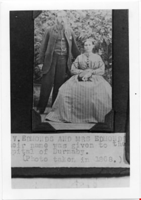
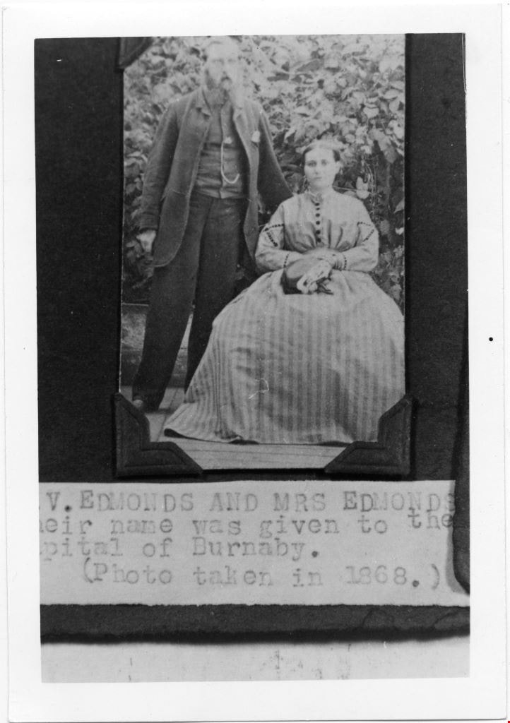
Mr and Mrs V Edmonds
https://search.heritageburnaby.ca/link/museumdescription4779
- Repository
- Burnaby Village Museum
- Date
- 1868
- Collection/Fonds
- Burnaby Village Museum Photograph collection
- Description Level
- Item
- Physical Description
- 1 photograph : b&w ; 12.6 x 8.8 cm ; copy print
- Scope and Content
- Portrait of married couple, he standing, she sitting, in front of some shrubbery.
- Repository
- Burnaby Village Museum
- Collection/Fonds
- Burnaby Village Museum Photograph collection
- Description Level
- Item
- Physical Description
- 1 photograph : b&w ; 12.6 x 8.8 cm ; copy print
- Material Details
- "Columbian files 1971" written on verso in black pen. "V. EDMONDS AND MRS EDMONDS / […]eir name was given to the / Capital of Burnaby. / (Photo taken in 1868.)" on typewritten label on front of photograph.
- Scope and Content
- Portrait of married couple, he standing, she sitting, in front of some shrubbery.
- History
- Part of a set of photographs from the Columbian Newspaper, which operated out of New Westminster under this name starting in 1900 until its dissolution in 1988. Photographs found in the collection of the Burnaby Village are dated 1971.
- Other Title Information
- title based on note on front of photograph
- Accession Code
- BV018.19.5
- Access Restriction
- No restrictions
- Reproduction Restriction
- May be restricted by third party rights
- Date
- 1868
- Media Type
- Photograph
- Scan Resolution
- 600
- Scan Date
- 24-04-2018
Images