Narrow Results By
Subject
- Agricultural Tools and Equipment 1
- Agriculture - Crops 1
- Agriculture - Farms 2
- Agriculture - Fruit and Berries 1
- Animals - Horses 1
- Buildings 2
- Buildings - Civic - Museums 1
- Buildings - Commercial 2
- Buildings - Commercial - Department Stores 18
- Buildings - Commercial - Hardware Stores 1
- Buildings - Commercial - Hotels and Motels 1
- Buildings - Commercial - Theatres 1
Creator
- Alger, Horatio, Jr., 1832-1899 1
- Askey, Jim 1
- Benson, Don, 1933- 1
- Blackmore, R. D., (Richard Doddridge), 1825-1900 1
- Black, Newton Henry, 1874-1961 1
- Brown, William Thomas 1
- Buckley, Arabella B. (Arabella Burton), 1840-1929 1
- Burnett, Geoffrey K. 4
- Burnett & McGugan, Engineers and Surveyors 10
- Chambers, L. B. 1
- Christy, Howard Chandler, 1873-1952 1
- Churchill, Winston, 1871-1947 1
Person / Organization
- Armstrong Avenue School 1
- Baehr, G. A. 1
- Barnet School 1
- Boy Scouts of Canada 1
- Brackman-Ker Milling Company 1
- British Columbia Provincial Police 1
- British Columbia Telephone Company 1
- Burnaby Mountain Centennial Park 1
- Burnaby Village Museum 1
- Burton, Charles Luther 3
- Burton, Edgar G. 3
- Byrne, Mary 1
![Survey and Subdivision plans in New Westminster District Group 1 & Group 2 - Burnaby, Port Moody, Coquitlam, Mission and Map of Port Simpson Harbour, [190-] thumbnail](/media/hpo/_Data/_BVM_Cartographic_Material/1977/1977_0093_0111_001.jpg?width=280)
Survey and Subdivision plans in New Westminster District Group 1 & Group 2 - Burnaby, Port Moody, Coquitlam, Mission and Map of Port Simpson Harbour
https://search.heritageburnaby.ca/link/museumdescription7080
- Repository
- Burnaby Village Museum
- Date
- [190-]
- Collection/Fonds
- Burnaby Village Museum Map collection
- Description Level
- File
- Physical Description
- 9 plans : 3 plans : blueprint ink on paper + 4 plans : black ink and graphite on linen + 2 plans : graphite on paper mounted on 2 sides of cardboard 76 x 102 cm
- Scope and Content
- File consists of a large board with five plans in New Westminster District, Group 1 mounted on one side and three plans in New Westminster District, Group 1 and a map of Port Simpson Harbour mounted on the other side. Side A: 1. Plan: blueprint on paper ; 30 x 20 cm. Title reads: "Plan of / Subdi…
- Repository
- Burnaby Village Museum
- Collection/Fonds
- Burnaby Village Museum Map collection
- Description Level
- File
- Physical Description
- 9 plans : 3 plans : blueprint ink on paper + 4 plans : black ink and graphite on linen + 2 plans : graphite on paper mounted on 2 sides of cardboard 76 x 102 cm
- Material Details
- Scales vary (One chain equals 792 inches)
- Indexed number on tape on edge of board reads "111"
- Scope and Content
- File consists of a large board with five plans in New Westminster District, Group 1 mounted on one side and three plans in New Westminster District, Group 1 and a map of Port Simpson Harbour mounted on the other side. Side A: 1. Plan: blueprint on paper ; 30 x 20 cm. Title reads: "Plan of / Subdivision of Part of D.L.172.GR.I.N.W.D." Scale: 200 feet = 1inch. dated, Feb.22, 1908, signed by land surveyor "Noel Humphreys" (Geographic location: District Lot 172, Burnaby) 2. Plan : graphite and blue crayon on paper ; 21.5 x 22 cm. Title in blue crayon reads: "N.E.1/4 & NW 1/4 Sec.25 / Tp 18". Scale: 10 chains=1 inch (Geographic location: Mission) 3. Plan : graphite on paper ; 31.5 x 16 cm. Title in blue crayon reads: "Lot 350_ Gr.1" with initials "RB". Scale : 3 chains = 1 inch. (Geographic location: Port Moody) 4. Plan ; graphite on linen ; 40 x 54 cm. Title in blue crayon reads: "Lot 190_Gr.1" with initials "RB". Plan covers area in Lot 190 including streets identified as; McInness Street, First Street, Second Street, Third Street, Fourth Street running through District Lot. (Geographic location: Port Moody) 5. Plan: blueprint on paper ; 50.5 x 57.5 cm. Title reads: "Plan of / T.F. Sinclair's Quarry Site. / SituateOnPittRiver.Sec.122T.P.40. / East of Coast Mer." Scale: 5 chains = 1inch. dated June 30 1908 [sic] Plan covers site of T.F. Sinclair's quarry in Section 22 of Township 40 on the shore of Pitt River. (Geographic location: Coquitlam ) Side B: 1. Map : blueprint on paper ; 50 x 38 cm. Scale: 40 chains - 1 inch. Title reads: "Map of Land on / Port Simpson Harbor". Scale : 40 chains = 1 inch Map covers subdivided land on the North Coast of British Columbia on the Tsimpsean Pennisula bordered by water identified as "Work Channel" to the west, "Port Simpson Harbour" to the east and land identified as "Indian Reserve" [Lax Kw'alaams] to the south. Names of property owners are identified in subdivided sections and area of land along the shore of "Work Channel" is identified as "Goverment Reserve". Blueprint includes inset "Key Map" with location of Port Simpson Harbour and Tsimpean Pennisula on the North Coast of British Columbia. 2. Plan : graphite on linen ; 24.5 x 46 cm. Title reads: "Portion of Lot 470 / Group 1" Scale : 2 chains = 1 inch. Plan covers a subdivided portion of District Lot 470, New Westminster District, Group 1 with streets identified as; "Pleasant Street", "Metta Street" and "Clarence Street". (Geographic location: Port Moody) 3. Plan : black ink on linen ; 40 x 30.5 cm. Title reads: "Plan / of / A Portion of the Foreshore / of / Lot 201 GR.2 / N.W.D. / Showing / Mill-Site". Scale : 100 feet = 1 inch. Plan is stamped in red ink: "Albert J. Hill, M.A., / Civil Engineer / And / Provincial Land Surveyor, / New Westminster, / B.C.". Survey notes in black ink read: "Surveyed Oct 9th 1908 for Messrs. / Roe & Abernathy and plan (duplicate / of this one) sent Oct. 8th / G.K. Burnett". (Geographic location : Port Moody) 4. Plan : black and red ink on line ; 63 x 29.5 cm. Title reads: "Port Moody / Butchard's Property". Scale : 200 feet = 1 inch. Plan covers subdivided lot into 16 parcels numbered I to XVI along the north shore of Burrard Inlet in Port Moody. Streets are identified as; George Street, Bruce Street, Norval Street, Nora Street, Elm Street, Pine Street, Orr Street and Orchard Street. Roads are identified as; West Road and East Road. (Geographic location : Port Moody)
- Creator
- Hill, Albert James
- Accession Code
- HV977.93.111
- Access Restriction
- No restrictions
- Reproduction Restriction
- No known restrictions
- Date
- [190-]
- Media Type
- Cartographic Material
- Scan Resolution
- 600
- Scan Date
- 2023-06-26
- Notes
- Title based on contents of file
Zoomable Images
![Survey and Subdivision plans in New Westminster District Group 1 & Group 2 - Burnaby, Port Moody, Coquitlam, Mission and Map of Port Simpson Harbour, [190-] thumbnail](/media/hpo/_Data/_BVM_Cartographic_Material/1977/1977_0093_0111_003_seadragon/1977_0093_0111_003.jpg?w=280)
Survey and Subdivision plans in New Westminster District Group 1 & Group 2 - Burnaby, Port Moody, Coquitlam, Mission and Map of Port Simpson Harbour, [190-]
Zoom into Image
![Survey and Subdivision plans in New Westminster District Group 1 & Group 2 - Maple Ridge, Surrey, ʷməθkʷəy̓əm (Musqueam), [190-] thumbnail](/media/hpo/_Data/_BVM_Cartographic_Material/1977/1977_0093_0082_001.jpg?width=280)
Survey and Subdivision plans in New Westminster District Group 1 & Group 2 - Maple Ridge, Surrey, ʷməθkʷəy̓əm (Musqueam)
https://search.heritageburnaby.ca/link/museumdescription7051
- Repository
- Burnaby Village Museum
- Date
- [190-]
- Collection/Fonds
- Burnaby Village Museum Map collection
- Description Level
- File
- Physical Description
- 10 plans : graphite and ink on paper and linen; various sizes mounted on 2 sides of cardboard 76 x 102 cm
- Scope and Content
- File consists of a large board with five plans in New Westminster District (Group 1 & Group 2) mounted on one side and five plans in New Westminster District (Group 2) mounted on the other side. Side A: 1.Plan : black ink on paper ; 48.5 x 33 cm. Title reads: "Plan of / The Subdivision of / The /…
- Repository
- Burnaby Village Museum
- Collection/Fonds
- Burnaby Village Museum Map collection
- Description Level
- File
- Physical Description
- 10 plans : graphite and ink on paper and linen; various sizes mounted on 2 sides of cardboard 76 x 102 cm
- Material Details
- Scales vary (One chain equals 792 inches)
- Indexed number on tape on edge of board reads "82"
- Scope and Content
- File consists of a large board with five plans in New Westminster District (Group 1 & Group 2) mounted on one side and five plans in New Westminster District (Group 2) mounted on the other side. Side A: 1.Plan : black ink on paper ; 48.5 x 33 cm. Title reads: "Plan of / The Subdivision of / The / S.E. 1/4 of S.W.1/4 / Sec.35, TP. 2 / N.W.DIST." Scale 200 feet = 1 inch Stamp in red ink on plan reads: "Albert J. Hill, M.A., / Civil Engineer / And / Provincial Land Surveyor, / New Westminster, / B.C." Annotation in blue crayon reads "RB_also Board 81" (Geographic location: Surrey) 2. Plan : black ink on linen ; 40 x 32 cm. Title reads: "Subdivision / of / N.W. 1/4 of Section 19, Group 2 (crossed out to read "Township 2) / New Westminster District , B.C." Sudivision includes lots in Section 19 to the east of Mud Bay Road. Stamp in red ink on plan reads: "Albert J. Hill, M.A., / Civil Engineer / And / Provincial Land Surveyor, / New Westminster, / B.C." Scale: 5 Chains = 1 Inch (Geographic location: Surrey) 3. Plan : graphite on paper ; 37.5 x 21.5 cm. Title reads:"Portion of Lot 51, Group 2, New Westminster District". Scale: 500 feet = 1 inch. (Geographic location: Surrey) 4. Plan : graphite on paper ; 24 x 17 cm. Title reads: "Lot 401, G1" Includes area identified as "Brickyard" Scale: 3 chains = 1 inch. Annotation in blue crayon reads: "Lot 401 GR. 1_RB" (Geographic location: Maple Ridge) 5. Plan : ink on paper ; 58.5 x 36.5 cm. Title reads: "Sketch plan / of / Cloverdale and Vicinity / from Nicomekl River / to McLellan Road". Plan identifies lot owners and land marks as; Robinson, Cloverdale Hotel and station, I.B. Fisher, D.W. McKenzie, A. Milton, T. Shannon, Johnson, O. Gummitt, F. Shannon, Murphy, D. McKenzie, J. Armstrong, W. Bell, R. Ludlow, J. Appel. Includes directional and natural flow of water in ditches and collecting basin. Annotation in blue pencil reads: "Sec. 5 Twp". (Geographic locaiton: Surrey) Side B: 1. Plan : black ink on linen ; 24 x 33 cm. Title reads: "Prop Outfall from River Road" (in blue crayon with initials RB). Plan refers to the proposed outfall of water from River Road to Fraser River and running through Lots 1, 2, B & A. Plan includes route of the proposed bridge approach on the south shore of the Fraser River. (Geographic location: Surrey) 2. Plan : black ink on linen ; 22.5 x 22.5 cm. Title reads: "Plan / of Proposed Outfall / from / River Road / to / Fraser River" Annotation in blue crayon reads: "Prop outfall from River Rd." and is initialed "RB". Scale: 132 feet = 1 inch. (Geographic location: Surrey) 3. Plan : black ink on paper ; 45 x 56 cm. Title reads: "Plan of South Half Sec.18, TP1 / Surrey Municipality". Plan includes subdivision of lots in Section 18, Township 1, bordered by Semiamu Bay [sic] (Semiahmoo Bay) to the west. (Geographic location: Surrey) 4. Plan : black ink on paper ; 45 x 30 cm. Title reads: "Plan of the / Subdivision of the / S.E. 1/4 Sec. 2, TP.7. / N.W.D." Subdivided lots north of the International Boundary are identified with names: "Rodgers, Fish & Hayward and Reid" Scale 5 chains = 1 inch. Stamp in blue ink reads: "I, ALBERT J. HILL / a British Columbia Land Surveyor, certify..." Signed by "Albert J. HIll. B.C.L.S." (Geographic location: Surrey) 5. Plan : black ink on linen ; 22.5 x 22.5 cm. Title reads: "ʷməθkʷəy̓əm (Musqueam) Ind. Res" (in blue crayon). Plan refers to an area of land on the south shore of the Fraser River in District Lot 1, identified as "ʷməθkʷəy̓əm (Musqueam) Indian Reserve" in Group 2, New Westminster District. Scale: I inch = 4 chains (Geographic location: Surrey)
- Creator
- Hill, Albert James
- Names
- ʷməθkʷəy̓əm (Musqueam)
- Accession Code
- HV977.93.82
- Access Restriction
- No restrictions
- Reproduction Restriction
- No known restrictions
- Date
- [190-]
- Media Type
- Cartographic Material
- Scan Resolution
- 600
- Scan Date
- 2023-06-26
- Notes
- Title based on contents of file
Zoomable Images
![Survey and Subdivision plans in New Westminster District Group 1 & Group 2 - Maple Ridge, Surrey, ʷməθkʷəy̓əm (Musqueam), [190-] thumbnail](/media/hpo/_Data/_BVM_Cartographic_Material/1977/1977_0093_0082_003_seadragon/1977_0093_0082_003.jpg?w=280)
Survey and Subdivision plans in New Westminster District Group 1 & Group 2 - Maple Ridge, Surrey, ʷməθkʷəy̓əm (Musqueam), [190-]
Zoom into Image
![Survey and Subdivision plans in New Westminster District Group 1 & Group 2 - Port Moody, Surrey
, [1898-1910] thumbnail](/media/hpo/_Data/_BVM_Cartographic_Material/1977/1977_0093_0073_001.jpg?width=280)
Survey and Subdivision plans in New Westminster District Group 1 & Group 2 - Port Moody, Surrey
https://search.heritageburnaby.ca/link/museumdescription7042
- Repository
- Burnaby Village Museum
- Date
- [1898-1910]
- Collection/Fonds
- Burnaby Village Museum Map collection
- Description Level
- File
- Physical Description
- 10 plans : graphite and ink on paper and linen; various sizes mounted on 2 sides of cardboard 76 x 102 cm
- Scope and Content
- File consists of a large board with four plans in New Westminster District mounted on one side and six plans mounted on the other side. Side A: 1. Plan : black ink and graphite on paper ; 46.5 x 37.5 cm. Title reads: "Bon Accord Hatchery / Sec 6 B5N R1W". Signed by Albert J. Hill P.L.S. August 1…
- Repository
- Burnaby Village Museum
- Collection/Fonds
- Burnaby Village Museum Map collection
- Description Level
- File
- Physical Description
- 10 plans : graphite and ink on paper and linen; various sizes mounted on 2 sides of cardboard 76 x 102 cm
- Material Details
- Scales vary (One chain equals 792 inches)
- Indexed number on tape on edge of board reads "73"
- Scope and Content
- File consists of a large board with four plans in New Westminster District mounted on one side and six plans mounted on the other side. Side A: 1. Plan : black ink and graphite on paper ; 46.5 x 37.5 cm. Title reads: "Bon Accord Hatchery / Sec 6 B5N R1W". Signed by Albert J. Hill P.L.S. August 12, 1903. Plan covers land identified as Section 6, Section 7, Located along the south shore of the Fraser River in Port Mann (Geographic location: Surrey). 2. Plan : black ink and graphite on paper ; 36 x 31 cm. Title reads: "Survey of Portions of Sec. 20 B5N R2W". Plan is stamped in red ink: "Albert J. Hill, Civil Engineer". Scale 4 chains = 1 inch. 3. Plan : black ink on linen ; 14 x 23 cm. Title reads:"Port Moody". Plan covers sections in Lot 191 (District Lot 191) bordered by Burrard Inlet to the west and Lot 235 and Lot 233 to the south. Streets identified include Water Street, Beauregard Street, Yonge Street, Clinton Street and Oxford Street. 4. Plan: graphite and ink on paper ; 43.5 x 64.5 cm. Title reads: "Sketch Plan Approved by Council [sic] / _[sic]1898". (No identifying geographic landmarks provided) Side B: 1. Plan : graphite on paper ; 53.5 x 31 cm. Title reads: "Plan of Lot 13, Gr. II, N.W. Dist". Sketch plan covers area along the Fraser River in District Lot 13, New Westminster District, Group 2. District Lot 13 is bordered by District Lot 14 (to the west) and Lot 12 (to the east). Natural geographic features within District Lot 13 are noted as "dense brush and fallen timber / sallal / rough spruce and cedar / swamp / fine alder / sallal / fine alder bottom land / fine brook". Scale: 3 chains = 1 inch (Geographic location: Surrey) 2. Plan : black ink on paper ; 50.5 x 34.5 cm. Title reads: "Indian Reserve / Opposite / New Westminster". Plan covers area on the south shore of the Fraser River in New Westminster District Group 2 in an area known as Brownsville. Lots are identified as District Lots 1, 2, 3, 4, 18, 17 and 8 and Sections A and B. Two areas of land are noted as "Indian Reserve"; one 6.3 acre parcel and one 104.25 acre parcel, both within District Lot 1. Note on plan reads: "N.B. this plan shows reserves and adjacent properties as they are on the ground". (Geographic location: Surrey) 3. Plan : black and col. ink on paper ; 19.5 x 31.5 cm. Title reads: "Bon Accord Road". Plan shows elevation. "Average section 10 feet = 1 inch". Plan is stamped in red ink: "Albert J. Hill, Civil Engineer and Provincial Land Surveyor, New Westminster, B.C." (Geographic location: Surrey) 4. Plan : black and col. ink on linen ; 16.5 x 25.5 cm. (no formal title) Plan covers area of Section 35, south of Yale Wagon Road and east of Quible Road. Plan is signed by "Albert J. Hill / B.C.L.S." (Geographic location: Surrey) 5. Plan: black and col. ink on linen ; 22.5 x 22.5 cm. (no formal title) Plan covers area between Yale Road and Townline Road in Surrey. Scale: 4 chains = 1 inch. Plan is signed by Albert J. Hill B.C.L.S. [190-] (Geographic location: Surrey) 6. Plan : graphite on paper ; 24 x 54 cm. (no formal title) Plan covers sectioned areas along Bon Accord Road. Sections are identified as " Sec. 8 / T.F. Patterson"; "Sec. 9 / Russell"; "Elliott_Burnett_Crean / Sec. 16"; "Dom. Govt. / Sec. 17". (Geographic location: Surrey, beneath the Port Mann bridge)
- Names
- ʷməθkʷəy̓əm (Musqueam)
- Accession Code
- HV977.93.73
- Access Restriction
- No restrictions
- Reproduction Restriction
- No known restrictions
- Date
- [1898-1910]
- Media Type
- Cartographic Material
- Scan Resolution
- 600
- Scan Date
- 2023-06-26
- Notes
- Title based on contents of file
- Note re plan 2B: The sight of Brownsville was also the former site of the Qayqayt First Nation and one of the main summer villages of the Kwantlen and ʷməθkʷəy̓əm (Musqueam) peoples
Zoomable Images
![Survey and Subdivision plans in New Westminster District Group 1 & Group 2 - Port Moody, Surrey
, [1898-1910] thumbnail](/media/hpo/_Data/_BVM_Cartographic_Material/1977/1977_0093_0073_003_seadragon/1977_0093_0073_003.jpg?w=280)
Survey and Subdivision plans in New Westminster District Group 1 & Group 2 - Port Moody, Surrey , [1898-1910]
Zoom into Image
![Survey and Subdivision plans in New Westminster District Group 2 - Surrey and Map of Surrey Municipality, [190-] thumbnail](/media/hpo/_Data/_BVM_Cartographic_Material/1977/1977_0093_0094_003.jpg?width=280)
Survey and Subdivision plans in New Westminster District Group 2 - Surrey and Map of Surrey Municipality
https://search.heritageburnaby.ca/link/museumdescription7063
- Repository
- Burnaby Village Museum
- Date
- [190-]
- Collection/Fonds
- Burnaby Village Museum Map collection
- Description Level
- File
- Physical Description
- 5 plans : blueprints on paper ; various sizes mounted on 2 sides of cardboard 76 x 102 cm
- Scope and Content
- File consists of a large board with two plans in New Westminster District (Group 2) mounted on one side and three plans in New Westminster District (Group 2) mounted on the other side. Side A: 1. Plan : blueprint on paper ; 75.5 x 64.5 cm. Title reads: "South Westminster / Plan/ of Subdivision of…
- Repository
- Burnaby Village Museum
- Collection/Fonds
- Burnaby Village Museum Map collection
- Description Level
- File
- Physical Description
- 5 plans : blueprints on paper ; various sizes mounted on 2 sides of cardboard 76 x 102 cm
- Material Details
- Scales vary (One chain equals 792 inches)
- Indexed number on tape on edge of board reads 94"
- Scope and Content
- File consists of a large board with two plans in New Westminster District (Group 2) mounted on one side and three plans in New Westminster District (Group 2) mounted on the other side. Side A: 1. Plan : blueprint on paper ; 75.5 x 64.5 cm. Title reads: "South Westminster / Plan/ of Subdivision of / Lot 440, G2, E1/2Sec36, NE1/4Sec25, N1/2ofSE1/4Sec25, T4.NW1/4S31,T2.". Subdivision plan covers subdivided property in Lot 440 and Section 36, Section 25 in New Westminster, Group 2, Township 4 (Delta) and Section 31 in Township 2 (Surrey). Includes inset map noting property in "South Westminster". Map is bordered by Burrard Inlet to the north and Mud Bay to the south. (Geographic locations: North Delta and Surrey) 2. Plan : blueprint on paper ; 22.5 x 59.5 cm. Title reads: "Plan / Shewing part of / Section 10 Block 5 North R.I.W. / New Westminster District / Lying North of B.C.S.Railway". Scale: 2 chains = 1 inch. Signed by A.S. Colton, District Land Surveyor. March 1, 1900. Plan covers property in Section 10, Block 5 North in New Westminster District, Group 2, along the south shore of the Fraser River with the Great Northern Railway running through. (Geographic location: Surrey) Side B: 1. Map : blueprint on paper ; 69 x 53 cm. Title reads: "Map / of / Surrey Municipality". Scale: 5 chains = 1 inch. Creator and surveyor of map is identified as "Albert J. Hill, M.A., Civil Engineer / And / Provincial Land Surveyor, / New Westminster, / B.C.". Map identifies property divisions including lots with names of property owners, Sections, Townships, Wards, waterways, major roads, railways and the Semiahmoo Indian Reserve on the shore of "Semiahmoo Bay" and an indian reserve (I.R.) located in Lot 1 along the south shore of the Fraser River. 2. Plan : blueprint on paper ; 21 x 40.5 cm. Title reads: "Plan / of / Sudivision of / Section 32, / Block 5 North Range 1 West, / District of New Westminster, B.C.". Scale: 4 chains = 1 inch. Sudivision plan is signed by Albert J. Hill, B.C. Land Surveyor. Plan covers Section 32, subdivided into 28 parcels. Section 32 is bordered by Section 29 (north), Section 33, Johnston Road (east), Section 34, Township 2, Town Line Road (south) and Section 31 (west). (Geographic location: Surrey) 3. Plan : blueprint on paper ; 49.5 x 37 cm. Title reads: "Traverse of the Waterline / in front of / Lots 3 and 4 Group 2 / N.W.D. / with G.N. Railway Rt of Way". Scale: 100 feet = 1 inch. Annotation on board below plan reads: "also see Boards 87 & 93 & 110". Location south of the Fraser River with old wharf identified and Great Northern Railway running east to west along the river. (Geographic location: Surrey)
- Names
- Great Northern Railway
- Accession Code
- HV977.93.94
- Access Restriction
- No restrictions
- Reproduction Restriction
- No known restrictions
- Date
- [190-]
- Media Type
- Cartographic Material
- Scan Resolution
- 600
- Scan Date
- 2023-06-26
- Notes
- Title based on contents of file
Zoomable Images
![Survey and Subdivision plans in New Westminster District Group 2 - Surrey and Map of Surrey Municipality, [190-] thumbnail](/media/hpo/_Data/_BVM_Cartographic_Material/1977/1977_0093_0094_003_seadragon/1977_0093_0094_003.jpg?w=280)
Survey and Subdivision plans in New Westminster District Group 2 - Surrey and Map of Surrey Municipality, [190-]
Zoom into Image
![Survey and Subdivision plans in New Westminster District Group 2 - Surrey, ʷməθkʷəy̓əm (Musqueam) Indian Reserve, [190-] thumbnail](/media/hpo/_Data/_BVM_Cartographic_Material/1977/1977_0093_0086_001.jpg?width=280)
Survey and Subdivision plans in New Westminster District Group 2 - Surrey, ʷməθkʷəy̓əm (Musqueam) Indian Reserve
https://search.heritageburnaby.ca/link/museumdescription7055
- Repository
- Burnaby Village Museum
- Date
- [190-]
- Collection/Fonds
- Burnaby Village Museum Map collection
- Description Level
- File
- Physical Description
- 12 plans : graphite and ink on paper and linen; various sizes mounted on 2 sides of cardboard 76 x 102 cm
- Scope and Content
- File consists of a large board with twelve plans (six plans mounted on each side). All plans are located in New Westminster District, Group 2, covering geographic areas within Surrey. Side A: 1. Plan : black ink on paper ; 20.5 x 57.5 cm. Title reads: "Extension of Tram Line / Hospital to Distill…
- Repository
- Burnaby Village Museum
- Collection/Fonds
- Burnaby Village Museum Map collection
- Description Level
- File
- Physical Description
- 12 plans : graphite and ink on paper and linen; various sizes mounted on 2 sides of cardboard 76 x 102 cm
- Scope and Content
- File consists of a large board with twelve plans (six plans mounted on each side). All plans are located in New Westminster District, Group 2, covering geographic areas within Surrey. Side A: 1. Plan : black ink on paper ; 20.5 x 57.5 cm. Title reads: "Extension of Tram Line / Hospital to Distillery St." Scales: Hor: 100 feet = 1 inch; Vert: 20 feet = 1 inch. tram line, hospital to distillery street; 2. Plan : black ink on linen ; 55 x 46.5 cm. (no title). Plan covers New Westminster District, Group 2, Lots 1,2, 3,4, A and B and the ʷməθkʷəy̓əm (Musqueam) Indian Reserve (1868).along the south shore of the Fraser River opposite City of New Westminster. Portion of land is highlighted in blue along the west border of the "ʷməθkʷəy̓əm (Musqueam) Indian Reserve" and between Lot 2 and Lot 1 and survey lines identified as "Mohun's Line" and Hill's Line. Stamp in red ink on plan reads: "Albert J. HIll, M.A. / Civil Engineer / and Provincial Land Surveyor / New Westminster / B.C." (Geographic location: Surrey also formerly known as Brownsville) 3. Plan : black ink on paper ; 34.5 x 23 cm. Title reads: "Lot 51, Gr.2" (in blue crayon). Plan covers area in New Westminster, Group 2, District Lot 51, north of Mud Bay with the Victoria Terminal Railway and Great Northern Railway lines identified. (Geographic location: Surrey) 4. Plan : graphite on paper ; 16.5 x 18 cm. Title reads: "Sec.20, B5N R2W" (underlined in blue crayon). Sketch plan covers and area in New Westmninster District, Group 2. Plan includes initials "RB" in blue crayon. Scale: 5 chains = 1 inch (Geographic location: Surrey) 5. Plan : graphite on paper with annotations in black ink ; 17 x 21 cm. Title reads: "N.W.1/4 Sec.12 TP2" (in blue crayon). Plan covers an area in New Westminster District Group 2 in Section 12, south of Bose Road. Identifying land marks include names: "Bose", "Smith" and "Church Land" Scale: 8 chains = 1 inch (Geographic location: Surrey) 6. Plan : graphite on paper ; 38 x 26.5 cm. (no title) Sketch plan covers areas in Lot 1 and Lot 2 with land identified as "Dominion Government". (could be survey for ʷməθkʷəy̓əm (Musqueam) Indian Reserve) (Geographic location: Surrey also formerly known as Brownsville) Side B: 1. Plan: black ink on paper ; 53.5 x 38 cm. Title reads:"Plan of Subdivision / of / Section 27, / Block 5 North, Range 2 West / New Westminster District". Scale: 4 chains = 1 inch. Includes area subdivided into 18 lots, south of Hjorth Road (104th Avenue) and west of Quible Road with Yale Road running through. Note in blue crayon reads: See also Bd.93) (Geographic location: Surrey) 2. Plan : black ink on paper ; 35 x 28 cm. Title reads: "Plan / of / Block A - L387A / Surrey". Scale: 2 chains = 1 inch. Annotaion in blue crayon reads: "Blk A / Lot 387a_Gr. 2". Plan covers New Westminster District Group 2, Block A, Lot 387 A, south of Parsons Slough and east of Latimer Road (192nd Street). Stamp in red ink on plan reads: "Albert J. HIll, M.A. / Civil Engineer / and Provincial Land Surveyor / New Westminster / B.C." (Geographic location: Surrey) 3. Plan : black ink on linen ; 50 x 42 cm. Title reads: Plan / of part of / Campbell River / running through / the South portion / of N.E. 1/4, Section 8, / Tp. 7, East of Coast Meridian / also / Showing location / of Shingle Mill and Dam". Scale: 100 feet = 1 inch. Plan covers the area in New Westminster District, Township 7, Section 8 with Hall's Prairie Road (184th Street) running through and intersecting with Campbell River. Vegetation, buildings, bridge, shingle mill are identified. (Geographic location: Surrey) 5. Plan : black ink on linen ; 21.5 x 16.5 cm. Title reads: "Sec.32, B5N R2W". Scale: 10 chains = 1 inch. Signed by "Albert J. Hill / B.C.L.S. / Dec. 23, 1908". Note on survey reads: "No actual survey / 40 ac. surveyed". (Geographic location: Surrey) 6. Plan : graphite on paper ; 22 x 15.5 cm. Title reads: "Position 'A5' Subjects / by _McKenzie" [Geographic location: Surrey]
- Creator
- Hill, Albert James
- Names
- ʷməθkʷəy̓əm (Musqueam)
- Accession Code
- HV977.93.86
- Access Restriction
- No restrictions
- Reproduction Restriction
- No known restrictions
- Date
- [190-]
- Media Type
- Cartographic Material
- Scan Resolution
- 600
- Scan Date
- 2023-06-26
- Notes
- Title based on contents of file
- Numeric stamp on edge of board reads: "86"
Zoomable Images
![Survey and Subdivision plans in New Westminster District Group 2 - Surrey, ʷməθkʷəy̓əm (Musqueam) Indian Reserve, [190-] thumbnail](/media/hpo/_Data/_BVM_Cartographic_Material/1977/1977_0093_0086_003_seadragon/1977_0093_0086_003.jpg?w=280)
Survey and Subdivision plans in New Westminster District Group 2 - Surrey, ʷməθkʷəy̓əm (Musqueam) Indian Reserve, [190-]
Zoom into Image
![Survey and Subdivision plans in New Westminster District, Group 2 - Surrey, ʷməθkʷəy̓əm (Musqueam) Indian Reserve, [190-] thumbnail](/media/hpo/_Data/_BVM_Cartographic_Material/1977/1977_0093_0099_003.jpg?width=280)
Survey and Subdivision plans in New Westminster District, Group 2 - Surrey, ʷməθkʷəy̓əm (Musqueam) Indian Reserve
https://search.heritageburnaby.ca/link/museumdescription7068
- Repository
- Burnaby Village Museum
- Date
- [190-]
- Collection/Fonds
- Burnaby Village Museum Map collection
- Description Level
- File
- Physical Description
- 11 plans : graphite and ink on paper and linen + blueprint ; various sizes mounted on 2 sides of cardboard 76 x 102 cm
- Scope and Content
- File consists of a large board with eleven plans in New Westminster District (Group 2) mounted on one side and five plans in New Westminster District (Group 2) mounted on the other side. Side A: 1. Plan : black ink on linen ; 19.5 x 32 cm. Title reads: "Yale Road / Sec.9 & 10 / B5N R2W" (in blue …
- Repository
- Burnaby Village Museum
- Collection/Fonds
- Burnaby Village Museum Map collection
- Description Level
- File
- Physical Description
- 11 plans : graphite and ink on paper and linen + blueprint ; various sizes mounted on 2 sides of cardboard 76 x 102 cm
- Material Details
- Scales vary (One chain equals 792 inches)
- Indexed number on tape on edge of board reads "99"
- Scope and Content
- File consists of a large board with eleven plans in New Westminster District (Group 2) mounted on one side and five plans in New Westminster District (Group 2) mounted on the other side. Side A: 1. Plan : black ink on linen ; 19.5 x 32 cm. Title reads: "Yale Road / Sec.9 & 10 / B5N R2W" (in blue crayon). Scale: 400 chains = 1 inch. Initals in blue crayon: "RB". Survey plan of Yale Road running through Sections 9 and 10 in New Westminster District, Group 2. (Geographic location: Surrey) 2. Plan : blueprint on paper ; 35.5 x 77.5 cm. Title reads: "Victoria Terminal Railway & Ferry Co. / Plan showing / Proposed Change of Wagon Road through White Rock, B.C" Scale: 400 feet = 1 inch. "H.C. Brice / Engineer in charge / New Westminster, B.C.". February 1906. Signed by "Walter Wilkie B.C.L.S.". Annotation in blue crayon reads: "Sub. of Parts of Sec. 10 & 11 / Tp. 1". Semiahmoo Indian Reserve, Washington Ave., Feb. 1906; 2. Yale Road, Sec.9, 10, B5N R2W, River Rd.; (Geographic location: White Rock) 3. Plan : graphite on paper ; 34 x 94 cm. Title reads: "Tp 7 / NW District" (in graphite) and "Campbell River / in Twp. 7" (in blue crayon). TP7, New Westminster District, Campbell R. in TP4, Coast Meridian, Bamford; (Geographic location: Surrey) Side B: 1. Plan : black ink and col. ink on paper ; 28 x 38.5 cm. Title reads: "G.N.R. / South approach to Wests bridge" (in blue crayon). Scale: 2 chains = 1 inch. Signed by Albert J. Hill, B.C.L.S. Plan covers land in Lot 2, Group 2 and ʷməθkʷəy̓əm (Musqueam) Indian Reserve with approach to bridge running through. (Geographic location: Surrey) 2. Plan : black ink and col. ink on paper ; 26.5 x 44.5 cm. Title reads: "Plan / of / River Frontage / across / Lot 1 BI.N.R.2W. and Lot 6, B.I.N.R.I.W. / N.W.D." Scale: 6 chains = 1 inch. Stamp in red ink reads: "Albert J. Hill, M.A., / Civil Engineer / and / Provincial Land Surveyor, / New Westminster, / B.C." (Geographic location: Surrey) 3. Plan : graphite and ink on paper ; 27 x 44.5 cm. (no formal title) Plan covers area between Yale Road, (north), Quible Road (west) and Townline Road (south). Scale: 4 chains = 1 inch. Signed by Albert J. Hill, B.C.L.S. Annotations in blue crayon read: "also Board 83 / Cancelled" (Geographic location: Surrey) 4. Plan : graphite on paper ; 35.5 x 21.5 cm. Title reads: "Sec 33 B.5N. R2W / see finished drawing Board 125". Initials in blue crayon "RB". Plan certifified by B.C. Provincial Land Surveyor in blue ink "Albert J. Hill". 5. Plan : black ink and col. ink on linen ; 15.5 x 22 cm. Title reads: " Lot 167 Gr. 2" (blue crayon). Scale: 200 feet = 1 inch. Signed by Albert J. Hill, Provincial Land Surveyor. Survey of aarea north of Cloverdale & Guichon Railway with area identified as "Gravel Pit". "Cancelled" in upper left corner of plan. (Geographic location: Surrey) 6. Plan : graphite on paper ; 27 x 27.5 cm. Title reads: "South Half / of / S.W.1/4 Sec.31 TP7 / N.W.D.". Scale: 5 chains = 1 inch. Other title at top of plan reads; "Edward Parr [sic] / Cloverdale". Covers area east of Coast Meridian Road in Section 36. (Geographic location: Surrey) 7. Plan : graphite on paper ; 20.5 x 16 cm. Title reads: "Survey of [sic] Sec. 16, Tp 1[sic] / ..." Other title in blue crayon reads: "N.E. 1/4 Sec. 16 / Twp. 1". (Geographic location: Surrey) 8. Plan : graphite on paper. ; 26.5 x 35 cm. (title is illegible) Plan covers are in New Westminster District, Group 2 along the south shore of the Fraser River. (Geographic location: Surrey)
- Creator
- Hill, Albert James
- Accession Code
- HV977.93.99
- Access Restriction
- No restrictions
- Reproduction Restriction
- No known restrictions
- Date
- [190-]
- Media Type
- Cartographic Material
- Scan Resolution
- 600
- Scan Date
- 2023-06-26
- Notes
- Title based on contents of file
Zoomable Images
![Survey and Subdivision plans in New Westminster District, Group 2 - Surrey, ʷməθkʷəy̓əm (Musqueam) Indian Reserve, [190-] thumbnail](/media/hpo/_Data/_BVM_Cartographic_Material/1977/1977_0093_0099_003_seadragon/1977_0093_0099_003.jpg?w=280)
Survey and Subdivision plans in New Westminster District, Group 2 - Surrey, ʷməθkʷəy̓əm (Musqueam) Indian Reserve, [190-]
Zoom into Image
![Survey plans in New Westminster District Group 1 - Maple Ridge, Pitt Meadows, [190-] thumbnail](/media/hpo/_Data/_BVM_Cartographic_Material/1977/1977_0093_0105_001.jpg?width=280)
Survey plans in New Westminster District Group 1 - Maple Ridge, Pitt Meadows
https://search.heritageburnaby.ca/link/museumdescription7074
- Repository
- Burnaby Village Museum
- Date
- [190-]
- Collection/Fonds
- Burnaby Village Museum Map collection
- Description Level
- File
- Physical Description
- 6 plans : graphite and ink on paper and linen; various sizes mounted on 2 sides of cardboard 76 x 102 cm
- Scope and Content
- File consists of a large board with three plans mounted on one side and two on the other side. All plans are located in New Westminster District, Group 2, covering geographic areas within Maple Ridge and Pitt Meadows. Side A: 1. Plan : black ink on linen ; 34 x 86 cm. Title reads: "Survey / of / …
- Repository
- Burnaby Village Museum
- Collection/Fonds
- Burnaby Village Museum Map collection
- Description Level
- File
- Physical Description
- 6 plans : graphite and ink on paper and linen; various sizes mounted on 2 sides of cardboard 76 x 102 cm
- Material Details
- Scales vary (One chain equals 792 inches)
- Indexed number on tape on edge of board reads "105"
- Scope and Content
- File consists of a large board with three plans mounted on one side and two on the other side. All plans are located in New Westminster District, Group 2, covering geographic areas within Maple Ridge and Pitt Meadows. Side A: 1. Plan : black ink on linen ; 34 x 86 cm. Title reads: "Survey / of / Dyke and Waterfront / Sec's 9, 10, 11, 13 & 14 / B5N R1E". Scale: 400 feet = 1 inch. Stamp in red ink on plan reads: "Albert J. Hill, M.A., / Civil Engineer / And / Provincial Land Surveyor, / New Westminster, / B.C." (Geographic location: Pitt Meadows) 2. 2 plans : black ink and graphite on paper ; 34.5 x 51 cm. Titles read: "Survey / For Highway / in / Section 4, Township 15, / New Westminster District. / For Maple Ridge Council." and "Survey / for Highway / in / Section 5, Tp. 15, / New Westminster Dist. / For Maple Ridge Council." Survey plan in Section 5, Township 15, covers SW quarter of Sec. 5, Tp. 15 with "Indian Reserve" (Whonnock Indian Reserve No. 1 - Kwantlen First Nation) identified. Stamp in red ink on plan reads: "Albert J. Hill, M.A., / Civil Engineer / And / Provincial Land Surveyor, / New Westminster, / B.C." Scales vary per drawing: 4 chains = 1 inch and 2 chains = 1 inch. (Geographic location: Maple Ridge) 3. Plan, black ink and graphite on paper ; 41 x 34 cm. Title reads: "Plan / of Subdivision / of / Fractional S.E. Quarter / of Sec. 6, TP. 15 / New Westminster District". Scale: 4 chains = 1 inch tamp in red ink on plan reads: "Albert J. Hill, M.A., / Civil Engineer / And / Provincial Land Surveyor, / New Westminster, / B.C." . Annotation in blue crayon reads: "also Board 122. (Geographic location: Maple Ridge) Side B: 1. Plan : black ink and col. red ink on linen ; 25.5 x 16 cm. Title reads: "Plan of Survey in Lot 398 Gr. 1 / For Lougheed & Abernathy". Scale: 3 chains = 1 inch. Plan is signed by "G.K. Burnett" September 25, 1907. (Geographic location: Maple Ridge) 2. Plan : graphite on paper with annotations in blue ; 91 x 67 cm. Title on survey plan reads: "Lot 441, 439, 438, 440, Gr. 1 / Showing bank of Stave River" (in blue crayon). Survey plan includes lot numbers and identifies "Indian Reserve" (Whonnock Indian Reserve No. 1 - Kwantlen First Nation) (Geographic location: Maple Ridge)
- Accession Code
- HV977.93.105
- Access Restriction
- No restrictions
- Reproduction Restriction
- No known restrictions
- Date
- [190-]
- Media Type
- Cartographic Material
- Scan Resolution
- 600
- Scan Date
- 2023-06-26
- Notes
- Title based on contents of file
Zoomable Images
![Survey plans in New Westminster District Group 1 - Maple Ridge, Pitt Meadows, [190-] thumbnail](/media/hpo/_Data/_BVM_Cartographic_Material/1977/1977_0093_0105_003_seadragon/1977_0093_0105_003.jpg?w=280)
Survey plans in New Westminster District Group 1 - Maple Ridge, Pitt Meadows, [190-]
Zoom into Image
Tennyson's Idylls of the king
https://search.heritageburnaby.ca/link/museumlibrary1879
- Repository
- Burnaby Village Museum
- Collection
- Special Collection
- Material Type
- Book
- Accession Code
- HV982.24.15
- Call Number
- 821.8 TEN 1922
- Contributor
- French, Charles Wallace, 1858-1920
- Place of Publication
- New York
- Publisher
- Macmillan
- Publication Date
- 1922
- Series
- Macmillan's pocket classics
- Printer
- Norwood Press
- Physical Description
- xxiv, 434 p. : front ; 15 cm.
- Inscription
- Front endpaper: "Place stamp here" [written in pencil] "R.A. Pound 720 - Royal Ave New Westminster B.C. May 1 1925" [written in pencil] Back endpaper: "R.A.P. MB 60" [written in pencil] "Nixons Book Store New Westminster, B.C." [stamped in blue ink]
- Library Subject (LOC)
- English literature--Historical texts
- Poetry--historical texts
- Notes
- edited with introduction and notes by Charles W. French
- Includes index.
- Copy of book published in 1912 available.
Third book of reading lessons
https://search.heritageburnaby.ca/link/museumlibrary3852
- Repository
- Burnaby Village Museum
- Collection
- Special Collection
- Material Type
- Book
- Accession Code
- BV995.15.77
- Call Number
- 428.6 ONT
- Place of Publication
- Toronto, Ont.
- Publisher
- WM. Warwick
- Publication Date
- c1875
- Printer
- Dudley & Burns
- Physical Description
- viii, 340 p. : ill. ; 18 cm.
- Inscription
- "A. Taylor / Alexander Hugh / Taylor 1875 / Nov. 26 1875" - handwritten in pencil on endpaper (front). "Harry Tidy / New Westminster B.C." - handwritten in pencil on flyleaf. "Alexander Hugh Taylor Queen St. 1785 / Parlament St. School / [sic] / December 13" -- handwritten in pen on flyleaf verso. "A Taylor 1. / h. Mamc 2. / Mrs H. Barrows 3" -- handwritten in pencil on endpaper (back).
- Library Subject (LOC)
- Readers (Elementary)
- English language
- Textbooks
- Object History
- Source is "City of Burnaby (Eagles House)"
- Notes
- Includes index.
- W.M. Warwick, 8 & 10 Wellington St. East
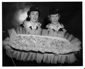
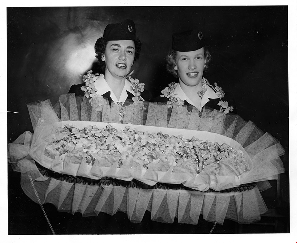
Trans Canada Airlines staff with tray of orchids
https://search.heritageburnaby.ca/link/museumdescription17429
- Repository
- Burnaby Village Museum
- Date
- 5 May 1954
- Collection/Fonds
- Simpsons-Sears Limited Burnaby fonds
- Description Level
- Item
- Physical Description
- 1 photograph : b&w ; 25.5 x 20.5 cm
- Scope and Content
- Photograph of two unidentified members of Trans Canadian Airlines holding a large tray of orchids. The orchids were handing out to shoppers during the opening of the Simpsons-Sears store in Burnaby on May 5, 1954. The air lines staff are dressed in uniforms and wearing leis around their necks.
- Repository
- Burnaby Village Museum
- Collection/Fonds
- Simpsons-Sears Limited Burnaby fonds
- Description Level
- Item
- Physical Description
- 1 photograph : b&w ; 25.5 x 20.5 cm
- Scope and Content
- Photograph of two unidentified members of Trans Canadian Airlines holding a large tray of orchids. The orchids were handing out to shoppers during the opening of the Simpsons-Sears store in Burnaby on May 5, 1954. The air lines staff are dressed in uniforms and wearing leis around their necks.
- Geographic Access
- Kingsway
- Street Address
- 4750 Kingsway
- Accession Code
- BV021.26.176
- Access Restriction
- No restrictions
- Reproduction Restriction
- May be restricted by third party rights
- Date
- 5 May 1954
- Media Type
- Photograph
- Historic Neighbourhood
- Central Park (Historic Neighbourhood)
- Planning Study Area
- Maywood Area
- Photographer
- On-The-Spot Photographers
- Notes
- Title based on contents of photograph
- Stamp on verso of photograph reads: "ON-THE-SPOT PHOTOGRAPHERS / NEW WESTMINSTER, B.C."
- Note in pencil on verso of photograph reads: "94"
- Photograph was removed from original scrapbook that included photographs, newspaper clippings, textual records and ephemera
Images
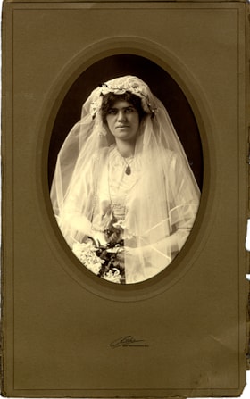
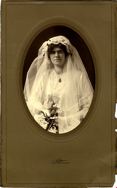
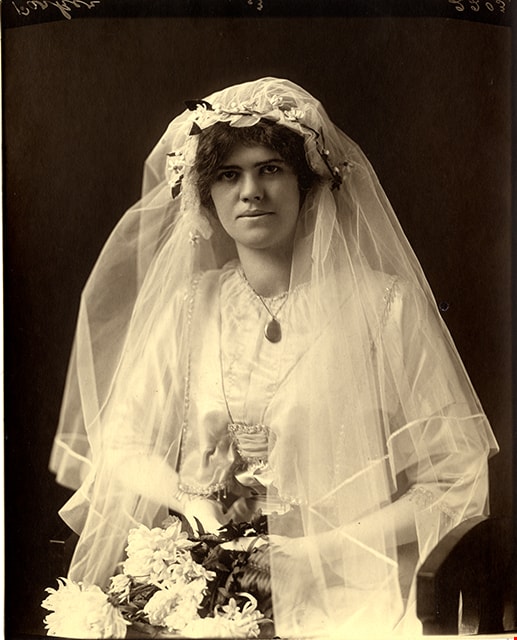
Wedding portrait of Sarah Love Parker
https://search.heritageburnaby.ca/link/museumdescription18828
- Repository
- Burnaby Village Museum
- Date
- 20 Aug 1913
- Collection/Fonds
- Love family fonds
- Description Level
- Item
- Physical Description
- 1 photograph : sepia ; 25 x 20 cm in mat 41.5 x 25 with 24 x 16.5 cm (oval, sight)
- Scope and Content
- Photograph portrait of Sarah Love Parker in her wedding dress on her wedding day. Sarah Love married William Micheal Parker at St. Alban's Church in Burnaby, August 20, 1913.
- Repository
- Burnaby Village Museum
- Collection/Fonds
- Love family fonds
- Description Level
- Item
- Physical Description
- 1 photograph : sepia ; 25 x 20 cm in mat 41.5 x 25 with 24 x 16.5 cm (oval, sight)
- Material Details
- Photograph removed from mat
- Scope and Content
- Photograph portrait of Sarah Love Parker in her wedding dress on her wedding day. Sarah Love married William Micheal Parker at St. Alban's Church in Burnaby, August 20, 1913.
- Subjects
- Ceremonies - Weddings
- Names
- Parker, Sarah Maria Love
- Accession Code
- BV019.8.14
- Access Restriction
- No restrictions
- Reproduction Restriction
- No known restrictions
- Date
- 20 Aug 1913
- Media Type
- Photograph
- Scan Resolution
- 600
- Scan Date
- 2022-07-07
- Photographer
- Ritchie, Samuel J.
- Notes
- Title based on contents of photograph
- Mat is embossed with photographer: "Ritchie / New Westminster, B.C."
Images
Will and licenses of William Michael Parker
https://search.heritageburnaby.ca/link/museumdescription10083
- Repository
- Burnaby Village Museum
- Date
- 1943 and 1962
- Collection/Fonds
- Love family fonds
- Description Level
- Item
- Physical Description
- 1 p. of textual records
- Scope and Content
- Item consists of the last will and testament of William Michael Parker and two British Columbia Motor Vehicle Licences for William Michael Parker.The will is signed and witnessed on February 28, 1943 and the vehicle licence registrations are dated February 28, 1962. One vehicle license has the addr…
- Repository
- Burnaby Village Museum
- Collection/Fonds
- Love family fonds
- Description Level
- Item
- Physical Description
- 1 p. of textual records
- Material Details
- "DATED FEBRUARY 12th, 1943 / WILLIAM MICHAEL PARKER, / Testator: / Sarah Maria parker / Executrix / WILL / LIDSTER & ALLISON, / Barristers & Solicitors, / New Westminster, B.C." printed on outside fold of the document.
- Scope and Content
- Item consists of the last will and testament of William Michael Parker and two British Columbia Motor Vehicle Licences for William Michael Parker.The will is signed and witnessed on February 28, 1943 and the vehicle licence registrations are dated February 28, 1962. One vehicle license has the address 1390 Cumberland St. while the other has the address 7651 Cumberland St. [This is the date of the change in the street numbering system in Burnaby.]
- History
- See extensive history of Love Family and Love farmhouse located at Burnaby Village Museum.
- Accession Code
- BV012.31.15
- Access Restriction
- Restricted access
- Reproduction Restriction
- May be restricted by third party rights
- Date
- 1943 and 1962
- Media Type
- Textual Record
- Notes
- Title based on content of file
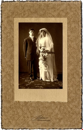
William and Sarah Parker
https://search.heritageburnaby.ca/link/museumdescription16711
- Repository
- Burnaby Village Museum
- Date
- 20 Aug. 1913
- Collection/Fonds
- Love family fonds
- Description Level
- Item
- Physical Description
- 1 photograph : sepia ; 14 x 9.5 cm mounted on mat 27.5 x 17 cm
- Scope and Content
- Photograph wedding portrait of William Parker and Sarah Parker (nee Love). The couple were married at St. Alban's Church in Burnaby, August 20, 1913.
- Repository
- Burnaby Village Museum
- Collection/Fonds
- Love family fonds
- Description Level
- Item
- Physical Description
- 1 photograph : sepia ; 14 x 9.5 cm mounted on mat 27.5 x 17 cm
- Scope and Content
- Photograph wedding portrait of William Parker and Sarah Parker (nee Love). The couple were married at St. Alban's Church in Burnaby, August 20, 1913.
- Subjects
- Ceremonies - Weddings
- Accession Code
- BV008.20.4
- Access Restriction
- No restrictions
- Reproduction Restriction
- No known restrictions
- Date
- 20 Aug. 1913
- Media Type
- Photograph
- Scan Resolution
- 600
- Scan Date
- June 14, 2021
- Scale
- 100
- Photographer
- Ritchie, Samuel J.
- Notes
- Title based on content of photograph
- Embossed label on matt reads: "Ritchie / New Westminster B.C."
Images

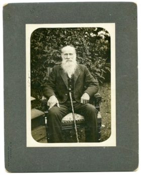
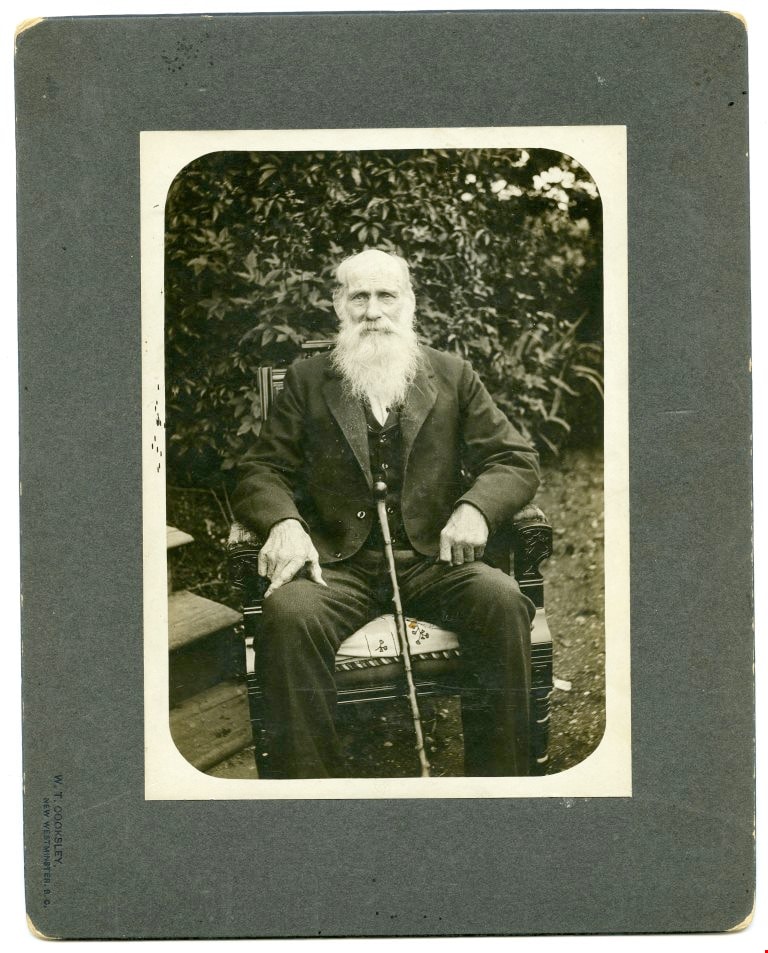
William Holmes
https://search.heritageburnaby.ca/link/museumdescription1267
- Repository
- Burnaby Village Museum
- Date
- July 1902
- Collection/Fonds
- William Holmes fonds
- Description Level
- Item
- Physical Description
- 1 photograph : b&w ; 18 x 13 cm mounted on board 24.5 x 19.5 cm
- Scope and Content
- Photograph of 89 year old William Holmes seated in an armchair holding a walking cane with shrubbery in background.
- Repository
- Burnaby Village Museum
- Collection/Fonds
- William Holmes fonds
- Description Level
- Item
- Physical Description
- 1 photograph : b&w ; 18 x 13 cm mounted on board 24.5 x 19.5 cm
- Material Details
- "Taken by W.T. Cooksley", "New Westminster, B.C.
- Scope and Content
- Photograph of 89 year old William Holmes seated in an armchair holding a walking cane with shrubbery in background.
- History
- William Holmes was the first non-Indigenous resident of Burnaby.
- Names
- Holmes, William
- Accession Code
- BV997.50.2
- Access Restriction
- No restrictions
- Reproduction Restriction
- No known restrictions
- Date
- July 1902
- Media Type
- Photograph
- Photographer
- Cooksley, William Thomas
- Notes
- Title based on contents of photograph
- Photographer embossed on front of mattboard reads: "W.T. Cooksley / New Westminster"
- Note in pencil on verso of photograph matt reads: "Wm Holmes Aged 89 Years and 9 Months", "July 1902"
- Note in blue ink on white paper strip on verso of photograph reads: "William Holmes left Ireland 16th May 1833 - settled in / Huron Co. Ont and established Holmsville" /"Left for New Westminster in 1858 - followed by his wife / and six daughters in 1860."
Images

Wire song : an illustrated history of the telephone in British Columbia, 1880-1930
https://search.heritageburnaby.ca/link/museumlibrary1356
- Repository
- Burnaby Village Museum
- Author
- Benson, Don, 1933-
- Publication Date
- 1991
- Call Number
- 384.609711 BEN
- Repository
- Burnaby Village Museum
- Collection
- Reference Collection
- Material Type
- Book
- ISBN
- 1895493005
- Call Number
- 384.609711 BEN
- Author
- Benson, Don, 1933-
- Place of Publication
- New Westminster, B.C.
- Publisher
- Westminster Pub.
- Publication Date
- 1991
- Physical Description
- 63 p. : ill., map, ports. ; 23 cm.
- Library Subject (LOC)
- Telephone--British Columbia--History
- Notes
- Includes bibliographical references (p. 59) and index.
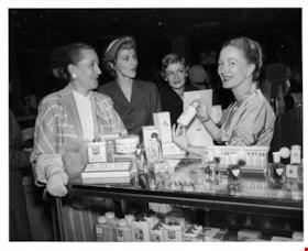
Women at Simpsons-Sears perfume counter
https://search.heritageburnaby.ca/link/museumdescription17417
- Repository
- Burnaby Village Museum
- Date
- 5 May 1954
- Collection/Fonds
- Simpsons-Sears Limited Burnaby fonds
- Description Level
- Item
- Physical Description
- 1 photograph : b&w ; 20.5 x 25.5 cm
- Scope and Content
- Photograph of a group of women standing at the perfume counter inside the Simpsons-Sears store in Burnaby on opening day, May 5, 1954. An arrangement of perfumes and women's products are on display on top of a glass counter.
- Repository
- Burnaby Village Museum
- Collection/Fonds
- Simpsons-Sears Limited Burnaby fonds
- Description Level
- Item
- Physical Description
- 1 photograph : b&w ; 20.5 x 25.5 cm
- Scope and Content
- Photograph of a group of women standing at the perfume counter inside the Simpsons-Sears store in Burnaby on opening day, May 5, 1954. An arrangement of perfumes and women's products are on display on top of a glass counter.
- Names
- Simpsons-Sears Limited
- Geographic Access
- Kingsway
- Street Address
- 4750 Kingsway
- Accession Code
- BV021.26.163
- Access Restriction
- No restrictions
- Reproduction Restriction
- May be restricted by third party rights
- Date
- 5 May 1954
- Media Type
- Photograph
- Historic Neighbourhood
- Central Park (Historic Neighbourhood)
- Planning Study Area
- Maywood Area
- Photographer
- On-The-Spot Photographers
- Notes
- Title based on contents of photograph
- Photograph was removed from original scrapbook that included photographs, newspaper clippings, textual records and ephemera
- Stamp on verso of photograph reads: "ON-THE-SPOT-PHOTOGRAPHERS / NEW WESTMINSTER B.C."
Images


Yi Fao : speaking through memory : a history of New Westminster's Chinese community 1858-1980
https://search.heritageburnaby.ca/link/museumlibrary1421
- Repository
- Burnaby Village Museum
- Author
- Wolf, Jim
- Owen, Patricia, 1978-
- Edition
- 1st ed.
- Publication Date
- c2008
- Call Number
- 971.133 WOL
- Repository
- Burnaby Village Museum
- Collection
- Reference Collection
- Material Type
- Book
- ISBN
- 9781894974400
- 1894974409
- Call Number
- 971.133 WOL
- Edition
- 1st ed.
- Author
- Wolf, Jim
- Owen, Patricia, 1978-
- Place of Publication
- Victoria
- Publisher
- Heritage House
- Publication Date
- c2008
- Physical Description
- 141 p. : ill. ; 25 cm.
- Library Subject (LOC)
- Chinese Canadians--British Columbia--New Westminster--History
- Chinese Canadians--British Columbia--New Westminster
- New Westminster (B.C.)--History
- New Westminster (B.C.)
- Biography
- Notes
- Includes bibliographical references (p. 141).