Narrow Results By
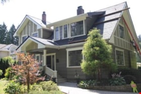
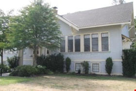
J.D. Shearer House
https://search.heritageburnaby.ca/link/landmark513
- Repository
- Burnaby Heritage Planning
- Description
- The J.D. Shearer House is a one and one-half storey British Arts and Crafts-style house distinguished by its picturesque roofline, half-timbered rough-cast stucco cladding on the upper floor and battered window casings. It is located on the south side of Buckingham Avenue at Haszard Street in Burna…
- Associated Dates
- 1912
- Formal Recognition
- Heritage Designation, Community Heritage Register
- Other Names
- John D. & Katherine Shearer House
- Street View URL
- Google Maps Street View
- Repository
- Burnaby Heritage Planning
- Other Names
- John D. & Katherine Shearer House
- Geographic Access
- Buckingham Avenue
- Associated Dates
- 1912
- Formal Recognition
- Heritage Designation, Community Heritage Register
- Enactment Type
- Bylaw No. 10423
- Enactment Date
- 26/08/1996
- Description
- The J.D. Shearer House is a one and one-half storey British Arts and Crafts-style house distinguished by its picturesque roofline, half-timbered rough-cast stucco cladding on the upper floor and battered window casings. It is located on the south side of Buckingham Avenue at Haszard Street in Burnaby's Deer Lake neighbourhood.
- Heritage Value
- Built in 1912, the J.D. Shearer House is an excellent example of the high quality residences constructed in the British Arts and Crafts style by affluent citizens in Burnaby's Deer Lake neighbourhood, promoted at the time as the equivalent of the prestigious Shaughnessy Heights development in Vancouver. The site of this house was part of Louis Claude Hill's Buckingham Estate subdivision. Development of these Edwardian era neighbourhoods in Burnaby was facilitated by the B.C. Electric Railway interurban line. In addition, the increasing availability of automobiles to the well-to-do families of the era sped up the process of urbanization in the outlying areas of Vancouver. Built for retired English military officer John D. Shearer and his wife, Katherine, the British Arts and Crafts design of the house represents associations with the Mother Country and the displays of patriotic loyalty considered desirable characteristics at the time. The picturesque charm and character of rural England is evoked in harmony with its woodland setting.
- Defining Elements
- Key elements that define the heritage character of the J.D. Shearer House include its: - location in the Buckingham Estate subdivision in the Deer Lake neighbourhood - residential form, scale and massing as exemplified by its one and one-half storey plus basement height, asymmetrical plan, front bay window and picturesque roofline - British Arts and Crafts details such as the half-timbering and rough-cast stucco on the upper storey, battered window casings, external clinker brick chimney on the east facade, deep overhanging closed eaves and bargeboards with distinctive lower returns - side gabled roof with gabled and shed dormers, clad in cedar - raised central entrance porch - irregular fenestration, including multi-paned transoms over casement windows - two internal red brick chimneys
- Historic Neighbourhood
- Burnaby Lake (Historic Neighbourhood)
- Planning Study Area
- Morley-Buckingham Area
- Function
- Primary Historic--Single Dwelling
- Primary Current--Single Dwelling
- Community
- Burnaby
- Cadastral Identifier
- 023-316-977
- Boundaries
- The J.D. Shearer House is comprised of a single residential lot located at 5573 Buckingham Avenue, Burnaby.
- Area
- 1044
- Contributing Resource
- Building
- Ownership
- Private
- Street Address
- 5573 Buckingham Avenue
- Street View URL
- Google Maps Street View
Images
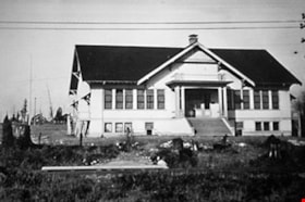
Kingsway East School
https://search.heritageburnaby.ca/link/landmark546
- Repository
- Burnaby Heritage Planning
- Description
- The Kingsway East School is a two-storey wood-frame Arts and Crafts styled building. The school, and the adjacent cenotaph and memorial tennis courts, comprise Burnaby South Memorial Park.
- Associated Dates
- 1913
- Formal Recognition
- Heritage Designation, Community Heritage Register
- Other Names
- Alan Emmott Centre
- Street View URL
- Google Maps Street View
- Repository
- Burnaby Heritage Planning
- Other Names
- Alan Emmott Centre
- Geographic Access
- Southoaks Crescent
- Associated Dates
- 1913
- Formal Recognition
- Heritage Designation, Community Heritage Register
- Enactment Type
- Bylaw No. 9807
- Enactment Date
- 23/11/1992
- Description
- The Kingsway East School is a two-storey wood-frame Arts and Crafts styled building. The school, and the adjacent cenotaph and memorial tennis courts, comprise Burnaby South Memorial Park.
- Heritage Value
- This school structure completed in 1913, the oldest surviving public education building in the city, was intended to be the auditorium and gymnasium for Burnaby’s first high school. However, because of the 1913 recession and the outbreak of the First World War, it was utilized as the Kingsway East Elementary School for the Edmonds District until 1921. Burnaby South High School opened here in 1922, and after it relocated this building was used for a variety of school purposes until it became redundant. The school was rehabilitated for community purposes in 2002-03 and renamed the Alan Emmott Centre to honor a former Mayor of Burnaby. The impressive scale of the Kingsway East School is indicative of the relative size of the community and its growing demand for schooling at the time of construction, illustrating the value that early community residents placed on education. Built to plans of the Burnaby School Board architect, Joseph Henry Bowman (1864-1943), it also indicates the individual values and design control exercised by the school board during this era. It is also significant for its Arts and Crafts style, allied to the typical Craftsman residential vocabulary, which was employed locally for school buildings of the Edwardian era. By using a common architectural vocabulary, this allowed the institution to reflect the values and aspirations of the local community. The Arts and Crafts style also demonstrated an allegiance to British educational antecedents and a demonstration of loyalty to the Mother Country.
- Historic Neighbourhood
- Edmonds (Historic Neighbourhood)
- Planning Study Area
- Kingsway-Beresford Area
- Function
- Primary Historic--Primary School
- Community
- Burnaby
- Cadastral Identifier
- P.I.D. No. 016-367-154 Legal Description: Lot 1, District Lot 96, Group 1 New Westminster District, Plan 86581
- Boundaries
- The Kingsway East School is comprised of a single municipally-owned property located at 6650 Southoaks Crescent, Burnaby.
- Area
- 6,070.00
- Contributing Resource
- Building
- Landscape Feature
- Structure
- Ownership
- Public (local)
- Documentation
- Heritage Site Files: PC77000 20. City of Burnaby Planning and Building Department, 4949 Canada Way, Burnaby, B.C., V5G 1M2
- Street Address
- 6650 Southoaks Crescent
- Street View URL
- Google Maps Street View
Images
Bancroft family subseries
https://search.heritageburnaby.ca/link/archivedescription63795
- Repository
- City of Burnaby Archives
- Date
- [1900]-1979
- Collection/Fonds
- Burnaby Historical Society fonds
- Description Level
- Subseries
- Physical Description
- Textual records and other materials
- Scope and Content
- Subseries consists of publications, correspondence and other miscellaneous papers relating to the Bancroft family's interests and work history. Topics include gardening, raising poultry, the Liberal government and the Royal Canadian Air Force. Also included in the subseries are photographs of the…
- Repository
- City of Burnaby Archives
- Date
- [1900]-1979
- Collection/Fonds
- Burnaby Historical Society fonds
- Subseries
- Bancroft family subseries
- Physical Description
- Textual records and other materials
- Description Level
- Subseries
- Accession Number
- BHS1986-44
- BHS2004-06
- Scope and Content
- Subseries consists of publications, correspondence and other miscellaneous papers relating to the Bancroft family's interests and work history. Topics include gardening, raising poultry, the Liberal government and the Royal Canadian Air Force. Also included in the subseries are photographs of the Bancroft family and friends and ephemera pertaining to agricultural farming and the air force.
- History
- Rose Croucher was born to Ann Eliza "Annie" (b. August 1861, d. 1962) and R. Coucher in January 1895. In 1907, the Croucher family moved to British Columbia. As a student, Rose studied geometrical drawing using Blair’s Canadian Drawing Series workbooks. On on February 21, 1914, Rose married James Oakes Bancroft in Vancouver, BC. Together they had three children: James A. (b. 1916 or 1917), Rosie (date unknown), and George E. (b. August 1927). The Bancroft family were poultry farmers throughout the early 1900s, transporting their farmed eggs from Burnaby to the Hudson’s Bay Company Vancouver using the British Columbia Electric Railway system. Rose Bancroft also served as Secretary-Treasurer of the Central Park Poultry Co-op Association in the 1920s until her husband's death in 1930 at the age of 42. In the late thirties and early forties, while James A. Bancroft was stationed in Calgary with the Royal Canadian Air Force, his younger siblings lived together with their mother and grandmother at 1963 21st Avenue in Burnaby. Rosie Bancroft studied French and English history in Social Studies in 1937; her brother George studied the seasons in General Science II in 1942. Rose died in 1965 at the age of 76.
- Media Type
- Textual Record
- Photograph
- Cartographic Material
- Creator
- Bancroft, Rose
- Notes
- MSS030, PC490, PC507, and MSS110
- Title based on creator and contents of subseries
Joseph H.C. Corsbie fonds
https://search.heritageburnaby.ca/link/museumdescription20275
- Repository
- Burnaby Village Museum
- Date
- [1941-1988]
- Collection/Fonds
- Joseph H.C. Corsbie fonds
- Description Level
- Fonds
- Physical Description
- 35 photographs + 1.5 cm textual records + 1 map + 1 book
- Scope and Content
- Fonds consists of photographs and documents relating to Joseph (Joe) Hardcastle Cumberland Corsbie during his service with the RCAF during World War II (1942-1945) along with photographs and docments relating to his personal and professional life (. Fonds is arranged into series: 1) Joseph H.C. Co…
- Repository
- Burnaby Village Museum
- Collection/Fonds
- Joseph H.C. Corsbie fonds
- Description Level
- Fonds
- Physical Description
- 35 photographs + 1.5 cm textual records + 1 map + 1 book
- Scope and Content
- Fonds consists of photographs and documents relating to Joseph (Joe) Hardcastle Cumberland Corsbie during his service with the RCAF during World War II (1942-1945) along with photographs and docments relating to his personal and professional life (. Fonds is arranged into series: 1) Joseph H.C. Corsbie RCAF records series 2) Joseph H.C. Corsbie personal and professional records series
- History
- Joseph “Joe” Hardcastle Cumberland Corsbie was born in 1913 in Peace River (Doe River) to parents Joseph Hardcastle Cumberland Corsbie and Winnifred Ann Mapleton Corsbie. As an adult Joe trained and served with the Royal Canadian Air Force as a navigator between 1942 and 1945. In 1945, while serving with the RCAF during World War II, Joe was awarded the Distinguished Flying Cross. After World War II, Joe returned to Peace River where he was elected as a Member of the Legislative Assembly serving as a Co-operative Commonwealth Federation MLA for one term between 1945 and 1948. In April 1948, Joe Corsbie married Margaret Carr in the Metropolitan United Church in Victoria followed by a reception held at the B.C. Legislature buildings. On their wedding day, the couple were honoured with a hand painted congratulatory certificate signed by members of the B.C. Legislature. In late, 1948, Joe lost the election and moved with his wife Margaret to Black Creek, B.C. to manage a co-op store. In 1949, the couple welcome their first child who they named Margaret after her mother. In 1950, Joe, Margaret and their daughter moved to a home on Charles Street in Burnaby and Joe began working as the General Manager of the Gulf and Fraser Fishermen’s Credit Union. In 1951, Joe and Margaret welcomed their second child, named Josesph after his father and in 1952, Joe, Margaret and family moved to 84 Springer Avenue, Burnaby where they lived until 1989. Between 1959 and 1976, Joe worked as a General Manager for the CU & C Health Services Society (later became Pacific Blue Cross). While working there, he focused on organizing both extended healthcare benefits and dental coverage for employee groups. In 1964, Joe Corsbie was elected to Burnaby Municipal Council and served one term between 1964 and 1968. Joe also served on the Burnaby Parks Commission (after 1968); served on the Board of Directors for Heritage Village, worked for a short period as a temporary curator for Heritage Village, represented the United Church in organizing and building St. Michael’s Care Centre and served on the Board of Director's. Joe Corsbie died in 1992 and his wife Margaret Corsbie died in 2004.
- Accession Code
- BV020.31
- Access Restriction
- No restrictions
- Reproduction Restriction
- No known restrictions
- Date
- [1941-1988]
- Media Type
- Photograph
- Textual Record
- Cartographic Material
- Arrangement
- Arrangement of fonds is based on the original arrangement by donor.
- Notes
- Title based on contents of fonds
Maurice Phillips collection
https://search.heritageburnaby.ca/link/archivedescription66716
- Repository
- City of Burnaby Archives
- Date
- 1930-1950
- Collection/Fonds
- Maurice Phillips collection
- Description Level
- Fonds
- Physical Description
- 3 maps + 1 brochure
- Scope and Content
- Collection consists of three maps; 1936 Burnaby lot map, 1950 map of the Fraser Valley, 1950s map of the Fraser Canyon and one brochure entitled "Corporation of Burnaby Attractively Priced Lands."
- Repository
- City of Burnaby Archives
- Date
- 1930-1950
- Collection/Fonds
- Maurice Phillips collection
- Physical Description
- 3 maps + 1 brochure
- Description Level
- Fonds
- Accession Number
- 2011-13
- Scope and Content
- Collection consists of three maps; 1936 Burnaby lot map, 1950 map of the Fraser Valley, 1950s map of the Fraser Canyon and one brochure entitled "Corporation of Burnaby Attractively Priced Lands."
- History
- Maurice Phillips was born in Victoria in 1919 and moved to East Pender Street in Vancouver during the 1930s. As a young man, he served as a cadet in the Seaforth Armory. When World War II broke out, Maurice was sent overseas with the First Battalion Seaforth Highlanders. This is where he met his future wife, Betty Joyce Thomas, who was herself serving as a member of the British Woman's Land Army (WLA). Maurice and Betty were married in Brighton, Sussex, in 1943. Betty (Thomas) Phillips travelled to Canada via the Queen Mary and stayed with Maurice's sisters and mother in Vancouver so that her daughter, Judith Phillips, would be born in Canada in 1944. Maurice was in Europe until 1945 and ended up as a Captain in the army. After the war, Maurice returned to work at Woodwards but, through his army contacts, went to work at Barber-Ellis, a wholesale paper and envelope manufacturer. He and his wife and daughter moved to Burnaby in 1948 or 1949, first on Royal Oak and then to a house on Waltham. This is where their son, William George Phillips, was born in 1950 and their second daughter, Susan Maureen Phillips, was born in 1953. The Phillips family often took trips to the Okanagan after the Hope-Princeton highway opened. Maurice also took William to Sḵwx̱wú7mesh along the "new" highway when it first opened. The Phillips family lived in Burnaby until Maurice was transferred east in 1960.
- Media Type
- Textual Record
- Cartographic Material
- Creator
- Phillips, Maurice
- Notes
- Title based on contents of fonds
- MSS158


