Narrow Results By
Heritage Park
https://search.heritageburnaby.ca/link/museumdescription3872
- Repository
- Burnaby Village Museum
- Date
- Mar. 1971
- Collection/Fonds
- Donald Copan collection
- Description Level
- Item
- Physical Description
- 1 architectural drawing ; 60 x 117 cm, folded to 20 x 30 cm
- Scope and Content
- Architectural drawing of the Heritage Village site by Hopping / Kovach / Grinnell Design Consultants Ltd., showing building locations, elevation, and planning in two phases.
- Repository
- Burnaby Village Museum
- Collection/Fonds
- Donald Copan collection
- Description Level
- Item
- Physical Description
- 1 architectural drawing ; 60 x 117 cm, folded to 20 x 30 cm
- Material Details
- Scale of 1" to 20'
- Scope and Content
- Architectural drawing of the Heritage Village site by Hopping / Kovach / Grinnell Design Consultants Ltd., showing building locations, elevation, and planning in two phases.
- Names
- Burnaby Village Museum
- Accession Code
- BV005.54.781
- Access Restriction
- Subject to FIPPA
- Reproduction Restriction
- Reproductions subject to FIPPA
- Date
- Mar. 1971
- Media Type
- Architectural Drawing
- Historic Neighbourhood
- Burnaby Lake (Historic Neighbourhood)
- Planning Study Area
- Morley-Buckingham Area
- Notes
- Title based on content of drawing
- Drawn by R.K.
![Landscape plan for front yard of Mawhinney house, [between 1988 and 1990] thumbnail](/media/hpo/_Data/_BVM_Architectural_Drawings/2018_0009_0048_001.jpg?width=280)
Landscape plan for front yard of Mawhinney house
https://search.heritageburnaby.ca/link/museumdescription15582
- Repository
- Burnaby Village Museum
- Date
- [between 1988 and 1990]
- Collection/Fonds
- Reverend Edward S. Gale fonds
- Description Level
- Item
- Physical Description
- 1 architectural drawing : pencil on parchment ; 30 x 56 cm
- Scope and Content
- Item consists of a landscape drawing identifying the layout and types of trees and bushes to be planted on the property of the Mervin Mawhinney house located at 7667 Burris Street in Burnaby while it was owned by Reverend Edward S. Gale. Grounds on the site were re-landscaped by Reverend Edward S. …
- Repository
- Burnaby Village Museum
- Collection/Fonds
- Reverend Edward S. Gale fonds
- Description Level
- Item
- Physical Description
- 1 architectural drawing : pencil on parchment ; 30 x 56 cm
- Scope and Content
- Item consists of a landscape drawing identifying the layout and types of trees and bushes to be planted on the property of the Mervin Mawhinney house located at 7667 Burris Street in Burnaby while it was owned by Reverend Edward S. Gale. Grounds on the site were re-landscaped by Reverend Edward S. Gale between 1988 and 1990..
- Geographic Access
- Burris Street
- Street Address
- 7667 Burris Street
- Accession Code
- BV018.9.48
- Access Restriction
- No restrictions
- Reproduction Restriction
- May be restricted by third party rights
- Date
- [between 1988 and 1990]
- Media Type
- Architectural Drawing
- Planning Study Area
- Morley-Buckingham Area
- Scan Resolution
- 600
- Scan Date
- May 3, 2021
- Scale
- 100
- Notes
- Title based on contents of photograph
Images
![Landscape plan for front yard of Mawhinney house, [between 1988 and 1990] thumbnail](/media/hpo/_Data/_BVM_Architectural_Drawings/2018_0009_0048_001.jpg)
![Landscape plan for front yard of Mawhinney house, [between 1988 and 1990] thumbnail](/media/hpo/_Data/_BVM_Architectural_Drawings/2018_0009_0049_001.jpg?width=280)
Landscape plan for front yard of Mawhinney house
https://search.heritageburnaby.ca/link/museumdescription15583
- Repository
- Burnaby Village Museum
- Date
- [between 1988 and 1990]
- Collection/Fonds
- Reverend Edward S. Gale fonds
- Description Level
- Item
- Physical Description
- 1 architectural drawing : blueline print with pencil ; 42.5 x 59.5 cm
- Scope and Content
- Item consists of an architectural landscape plan identifying the layout and types of trees and bushes to be planted in the front yard of the Mervin Mawhinney house located at 7667 Burris Street in Burnaby while it was owned by Reverend Edward S. Gale. Plantings identified include; Juniper, Rhodendr…
- Repository
- Burnaby Village Museum
- Collection/Fonds
- Reverend Edward S. Gale fonds
- Description Level
- Item
- Physical Description
- 1 architectural drawing : blueline print with pencil ; 42.5 x 59.5 cm
- Scope and Content
- Item consists of an architectural landscape plan identifying the layout and types of trees and bushes to be planted in the front yard of the Mervin Mawhinney house located at 7667 Burris Street in Burnaby while it was owned by Reverend Edward S. Gale. Plantings identified include; Juniper, Rhodendron, Azaleas, abelia, Rosh Rogos. Grounds on the site were re-landscaped by Reverend Edward S. Gale between 1988 and 1990.
- Geographic Access
- Burris Street
- Street Address
- 7667 Burris Street
- Accession Code
- BV018.9.49
- Access Restriction
- No restrictions
- Reproduction Restriction
- May be restricted by third party rights
- Date
- [between 1988 and 1990]
- Media Type
- Architectural Drawing
- Planning Study Area
- Morley-Buckingham Area
- Related Material
- See also BV018.9.30
- Scan Resolution
- 600
- Scan Date
- May 3, 2021
- Scale
- 100
- Notes
- Title based on contents of photograph
Images
![Landscape plan for front yard of Mawhinney house, [between 1988 and 1990] thumbnail](/media/hpo/_Data/_BVM_Architectural_Drawings/2018_0009_0049_001.jpg)
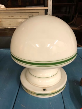
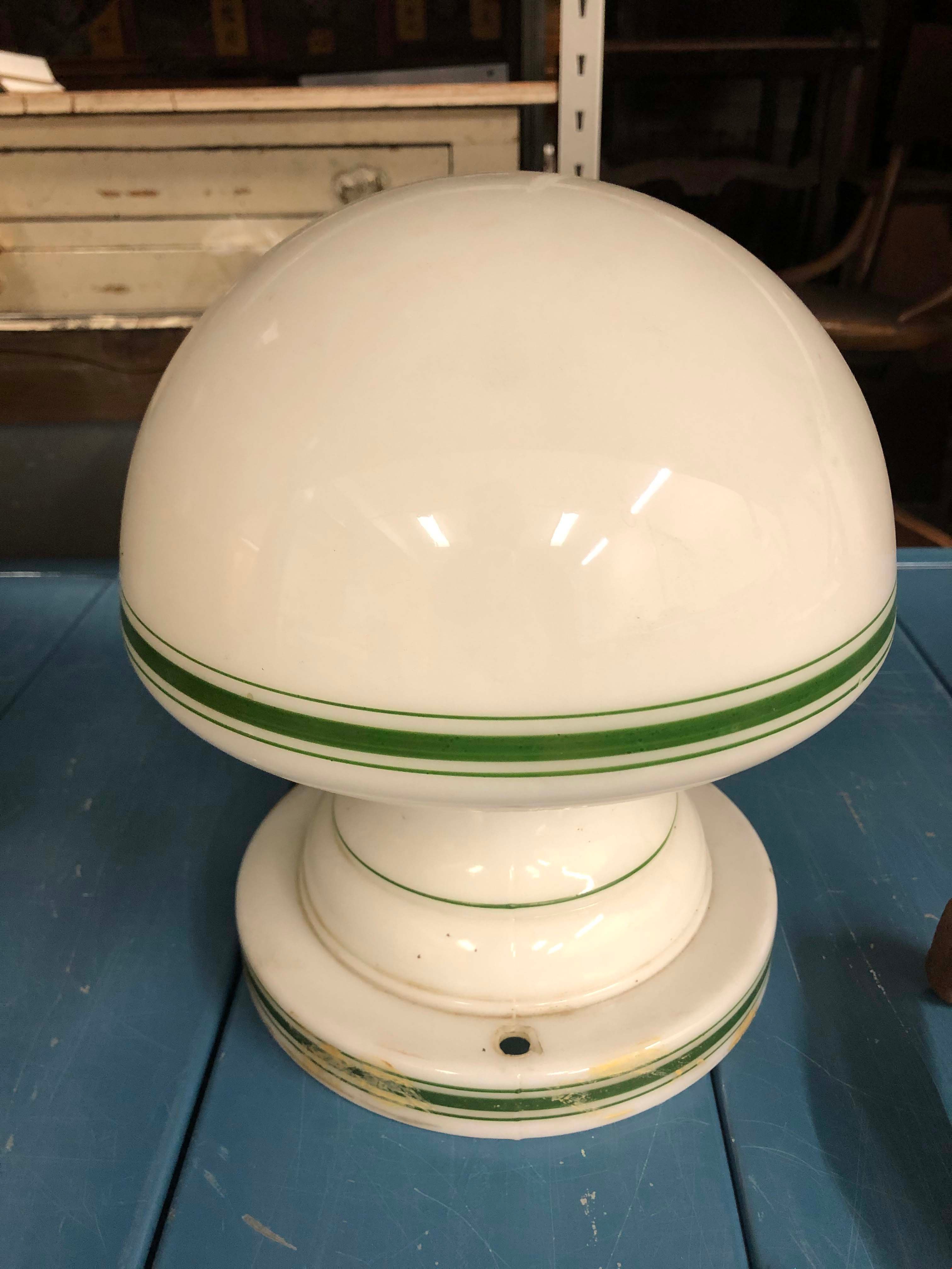
Light Fixture
https://search.heritageburnaby.ca/link/museumartifact90872
- Repository
- Burnaby Village Museum
- Accession Code
- BV020.40.23
- Description
- White glass light fixture with rounded bulb shape. The lamp and the base of the fixture hae a thick green line with two thin lines on either side. There are two holes in the base on opposite sides of each other. There is some tan/beige paint strokes around the base. An additional part is required to actually afix the lamp to the ceiling.
- Object History
- This is an original light fixture for the Eagles House. This house is located on Sperling Avenue and is under the care of the City of Burnaby Planning Department.
- Category
- 02. Furnishings
- Classification
- Lighting Equipment - - Lighting Devices
- Object Term
- Fixture, Lighting
- Colour
- White
- Green
- Historic Neighbourhood
- Burnaby Lake (Historic Neighbourhood)
- Planning Study Area
- Morley-Buckingham Area
Images
Plan of Heritage Village site
https://search.heritageburnaby.ca/link/museumdescription3865
- Repository
- Burnaby Village Museum
- Date
- [1971]
- Collection/Fonds
- Donald Copan collection
- Description Level
- Item
- Physical Description
- 1 architectural drawing : black line print on paper ; 28 x 44 cm
- Scope and Content
- Site plan of Heritage Village and surrounding area between Canada Way and Deer Lake, showing actual and potential locations for village buildings.
- Repository
- Burnaby Village Museum
- Collection/Fonds
- Donald Copan collection
- Description Level
- Item
- Physical Description
- 1 architectural drawing : black line print on paper ; 28 x 44 cm
- Material Details
- Scale 1" to 100'
- Scope and Content
- Site plan of Heritage Village and surrounding area between Canada Way and Deer Lake, showing actual and potential locations for village buildings.
- Names
- Burnaby Village Museum
- Accession Code
- BV005.54.782
- Access Restriction
- Subject to FIPPA
- Reproduction Restriction
- Reproductions subject to FIPPA
- Date
- [1971]
- Media Type
- Architectural Drawing
- Historic Neighbourhood
- Burnaby Lake (Historic Neighbourhood)
- Planning Study Area
- Morley-Buckingham Area
- Notes
- Title based on contents of plan

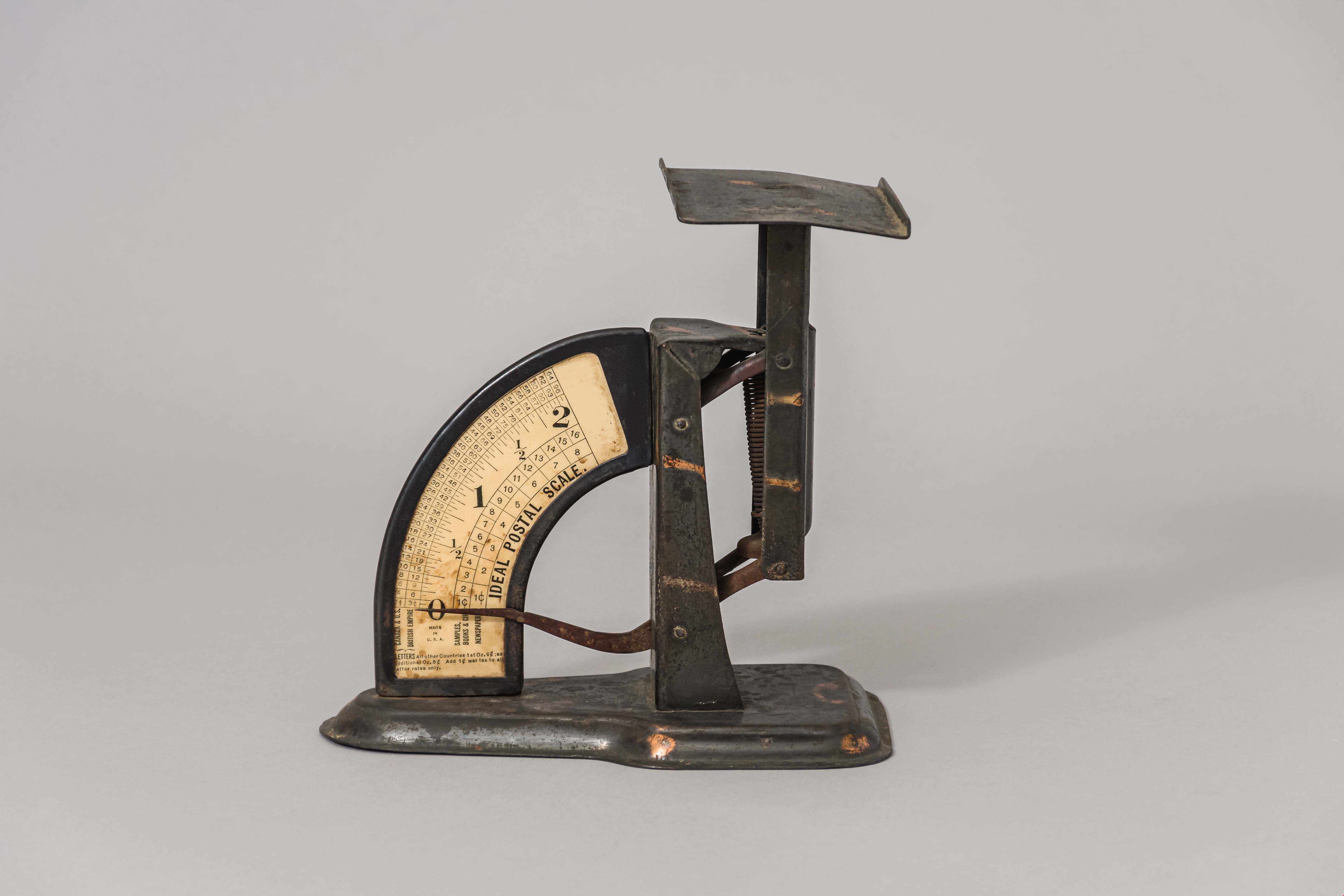
postal scale
https://search.heritageburnaby.ca/link/museumartifact15965
- Repository
- Burnaby Village Museum
- Accession Code
- HV983.61.3
- Description
- Postal scale, "IDEAL POSTAL SCALE"
- Object History
- Postal scale used by Harriet Woodward at the Burnaby Lake Post Office. The Burnaby Lake Post Office was run out of the Woodward cottage, owned by Harriet and Maude Woodward. The cottage was a prefabricated cottage erected in 1904. Harriet also began a small private school in the cottage, the first in Burnaby Lake. The cottage was enlarged with several additions until 1912 when the Woodwards built a new house.
- Classification
- Weights and Measurements Tools and Equipment - Scales
- Object Term
- Scale, Postal
- Geographic Access
- Sperling Avenue
- Street Address
- 5141 Sperling Avenue
- Historic Neighbourhood
- Burnaby Lake (Historic Neighbourhood)
- Planning Study Area
- Morley-Buckingham Area
Images
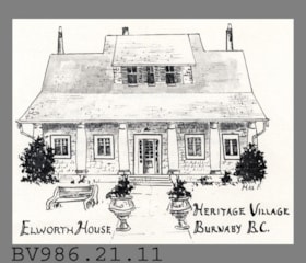
postcard
https://search.heritageburnaby.ca/link/museumartifact5636
- Repository
- Burnaby Village Museum
- Accession Code
- BV986.21.11
- Description
- Elworth House - Postcard - [197-?]. Advertising or souvenir card produced by Heritage Village Museum (Burnaby Village Museum) to promote Elworth House. The front of the card has an illustration by Max F of Elworth House. The back of the card gives a short description of Elworth House and its owner, Edwin Bateman.
- Classification
- Written Communication T&E - - Writing Media
- Object Term
- Postcard
- Geographic Access
- Deer Lake Avenue
- Street Address
- 6501 Deer Lake Avenue
- Historic Neighbourhood
- Burnaby Lake (Historic Neighbourhood)
- Planning Study Area
- Morley-Buckingham Area
Images


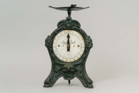
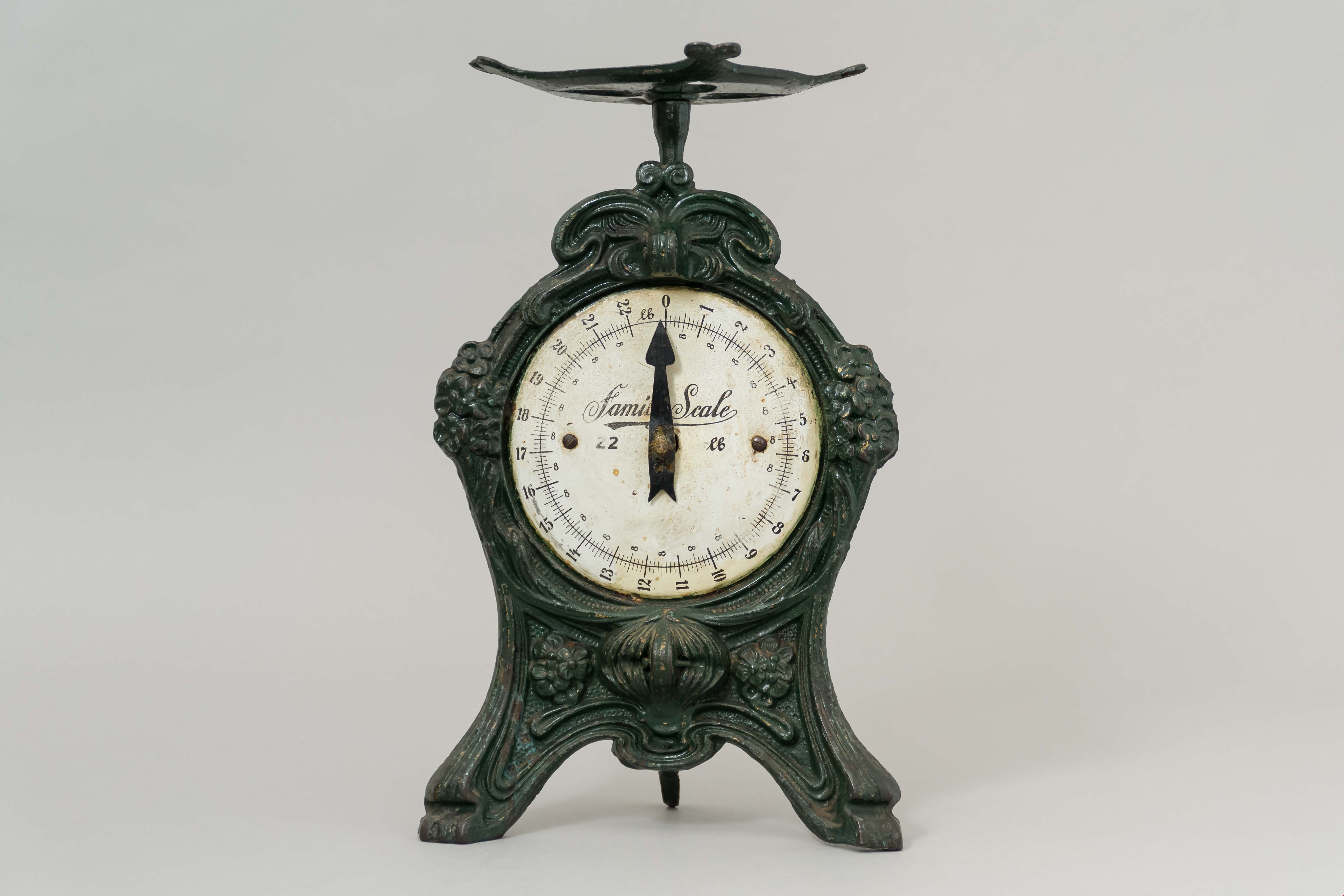
scale
https://search.heritageburnaby.ca/link/museumartifact29503
- Repository
- Burnaby Village Museum
- Accession Code
- HV973.56.53
- Description
- Scale, "Family Scale" "22 lb"; green painted cast metal; scratched into underside, "CLAUDE HILL DEC. 30 1---"
- Object History
- The scale was used by the Hill family. The family farm stood on Douglas Road at Deer Lake - where Burnaby Village Museum is today. The homestead was built in 1892, and as enlarged in 1905. The family grew strawberries on the farm. Bernard Hill worked as a surveyor for the municipality of Burnaby. He and his brother Claude were Alderman for the municipality of Burnaby.
- Category
- 04.Tools & Equipment for Materials
- Classification
- Weights and Measurements Tools and Equipment - Scales
- Object Term
- Scale
- Historic Neighbourhood
- Burnaby Lake (Historic Neighbourhood)
- Planning Study Area
- Morley-Buckingham Area
Images
Schedule "G" - Heritage Village Museum: Area covered by agreement with Century Park Museum Association
https://search.heritageburnaby.ca/link/museumdescription3868
- Repository
- Burnaby Village Museum
- Date
- June 1981
- Collection/Fonds
- Donald Copan collection
- Description Level
- Item
- Physical Description
- 1 architectural drawing : ink on paper ; 36 x 22 cm
- Scope and Content
- Item consists of a one page schedule from an unidentified document, showing a plan drawing of the Heritage Village site and indicating areas covered by agreement with the Century Park Museum Association (CPMA) and areas for potential future expansion of the village.
- Repository
- Burnaby Village Museum
- Collection/Fonds
- Donald Copan collection
- Description Level
- Item
- Physical Description
- 1 architectural drawing : ink on paper ; 36 x 22 cm
- Scope and Content
- Item consists of a one page schedule from an unidentified document, showing a plan drawing of the Heritage Village site and indicating areas covered by agreement with the Century Park Museum Association (CPMA) and areas for potential future expansion of the village.
- Names
- Burnaby Village Museum
- Accession Code
- BV005.54.785
- Access Restriction
- Subject to FIPPA
- Reproduction Restriction
- Reproductions subject to FIPPA
- Date
- June 1981
- Media Type
- Architectural Drawing
- Historic Neighbourhood
- Burnaby Lake (Historic Neighbourhood)
- Planning Study Area
- Morley-Buckingham Area
- Notes
- Title based on contents of drawing