Narrow Results By
Subject
- Advertising Medium - Signs and Signboards 1
- Animals - Horses 1
- Buildings 1
- Buildings - Civic 1
- Buildings - Civic - City Halls 1
- Buildings - Civic - Community Centres 1
- Buildings - Civic - Libraries 1
- Buildings - Commercial 1
- Buildings - Commercial - Service Stations 1
- Buildings - Heritage 2
- Buildings - Residential - Apartments 1
- Buildings - Schools 2
Creator
- Bartel, Mario 4
- Bureau of Post War Rehabilitation and Reconstruction Regional Planning Division 1
- Burnaby Monumental Works 1
- Burnaby Village Museum 1
- Burnett & McGugan, Engineers and Surveyors 1
- Campbell, Peg 1
- Carter, David 1
- Chapman, Fred 1
- Cooke, Rosemary 1
- C.O. Wickenden 1
- Friends of Interurban 1223 1
- Great Britain. Commonwealth War Graves Commission 1
Person / Organization
- Battersby, Frank 2
- Bird, Gloriana "Birdie" 1
- Boy Scouts of Canada 1
- British Columbia Electric Railway Company 1
- Burnaby City Hall 9
- Burnaby Civic Employees Union 3
- Burnaby Monumental Works 1
- Burnaby Public Library 1
- Burnaby, Robert 3
- Burnaby, Sarah 2
- Burnaby School Board 1
- Burnaby South High School 1
Destruction of Survey Monuments
https://search.heritageburnaby.ca/link/councilreport48191
- Repository
- City of Burnaby Archives
- Report ID
- 47548
- Meeting Date
- 21-Mar-1949
- Format
- Council - Mayor/Councillor/Staff Report
- Collection/Fonds
- City Council and Office of the City Clerk fonds
- Repository
- City of Burnaby Archives
- Report ID
- 47548
- Meeting Date
- 21-Mar-1949
- Format
- Council - Mayor/Councillor/Staff Report
- Collection/Fonds
- City Council and Office of the City Clerk fonds
Documents

Detail of brass plates for monuments in connection with school sites in Burnaby
https://search.heritageburnaby.ca/link/museumdescription11919
- Repository
- Burnaby Village Museum
- Date
- March 6, 1915
- Collection/Fonds
- Ronald G. Scobbie collection
- Description Level
- Item
- Physical Description
- 1 architectural drawing : pencil and watercolour on blueprint paper ; 43.5 x 30 cm
- Scope and Content
- Item consists of a detail drawing titled "Detail of Brass Plates / for monuments in connection / with School sites, Burnaby - / Full Size”.
- Repository
- Burnaby Village Museum
- Collection/Fonds
- Ronald G. Scobbie collection
- Description Level
- Item
- Physical Description
- 1 architectural drawing : pencil and watercolour on blueprint paper ; 43.5 x 30 cm
- Scope and Content
- Item consists of a detail drawing titled "Detail of Brass Plates / for monuments in connection / with School sites, Burnaby - / Full Size”.
- Creator
- McGugan, Donald Johnston
- Subjects
- Buildings - Schools
- Responsibility
- Burnett & McGugan, Engineers and Surveyors
- Accession Code
- BV003.83.11
- Access Restriction
- No restrictions
- Reproduction Restriction
- No known restrictions
- Date
- March 6, 1915
- Media Type
- Architectural Drawing
- Scan Resolution
- 600
- Scan Date
- 15-Jan-2021
- Scale
- 100
- Notes
- Title based on contents of drawing
- Text on bottom right corner of drawing reads: "Burnett & McGugan / C.E. & B.C. Land Surveyors / New Westminster, BC / 6th March 1915"
- Red crayon marking on plan reads: "001819"
- verso of page is blue
Images

![Monuments for school sites, [1915] thumbnail](/media/hpo/_Data/_BVM_Cartographic_Material/2003/2003_0083_0010_001.jpg?width=280)
Monuments for school sites
https://search.heritageburnaby.ca/link/museumdescription11915
- Repository
- Burnaby Village Museum
- Date
- [1915]
- Collection/Fonds
- Ronald G. Scobbie collection
- Description Level
- Item
- Physical Description
- 1 architectural drawing : pencil on paper ; 27.5 x 21 cm
- Scope and Content
- Item consists of a drawing titled "Plans of Proposed concrete monuments for corners of / school sites for Burnaby School Board".
- Repository
- Burnaby Village Museum
- Collection/Fonds
- Ronald G. Scobbie collection
- Description Level
- Item
- Physical Description
- 1 architectural drawing : pencil on paper ; 27.5 x 21 cm
- Scope and Content
- Item consists of a drawing titled "Plans of Proposed concrete monuments for corners of / school sites for Burnaby School Board".
- Creator
- McGugan, Donald Johnston
- Subjects
- Buildings - Schools
- Accession Code
- BV003.83.10
- Access Restriction
- No restrictions
- Reproduction Restriction
- No known restrictions
- Date
- [1915]
- Media Type
- Architectural Drawing
- Scan Resolution
- 600
- Scale
- 100
- Notes
- Title based on contents of drawing
- Red crayon marking on plan reads: "001819"
Images
![Monuments for school sites, [1915] thumbnail](/media/hpo/_Data/_BVM_Cartographic_Material/2003/2003_0083_0010_001.jpg)
Removal of Survey Monuments
https://search.heritageburnaby.ca/link/councilreport44654
- Repository
- City of Burnaby Archives
- Report ID
- 44471
- Meeting Date
- 11-Jul-1955
- Format
- Council - Mayor/Councillor/Staff Report
- Collection/Fonds
- City Council and Office of the City Clerk fonds
- Repository
- City of Burnaby Archives
- Report ID
- 44471
- Meeting Date
- 11-Jul-1955
- Format
- Council - Mayor/Councillor/Staff Report
- Collection/Fonds
- City Council and Office of the City Clerk fonds
Documents
![Cenotaph in New Westminster, [192-] thumbnail](/media/hpo/_Data/_BVM_Images/1995/1995_0008_0054_001.jpg?width=280)
Cenotaph in New Westminster
https://search.heritageburnaby.ca/link/museumdescription20623
- Repository
- Burnaby Village Museum
- Date
- [192-]
- Collection/Fonds
- David Geoffrey Llewellyn collection
- Description Level
- Item
- Physical Description
- 1 photograph : b&w ; 14 x 9 cm
- Scope and Content
- Photograph of New Westminster World War One memorial cenotaph with bronze statue of soldier. The memorial is located in a park in Leopold Place and was later moved to the northerly approach to the Patullo bridge and in 1954 to New Westminster City Hall.
- Repository
- Burnaby Village Museum
- Collection/Fonds
- David Geoffrey Llewellyn collection
- Description Level
- Item
- Physical Description
- 1 photograph : b&w ; 14 x 9 cm
- Scope and Content
- Photograph of New Westminster World War One memorial cenotaph with bronze statue of soldier. The memorial is located in a park in Leopold Place and was later moved to the northerly approach to the Patullo bridge and in 1954 to New Westminster City Hall.
- Geographic Access
- New Westminster
- Accession Code
- BV995.8.54
- Access Restriction
- No restrictions
- Reproduction Restriction
- No known restrictions
- Date
- [192-]
- Media Type
- Photograph
- Scan Resolution
- 600
- Notes
- Transcribed titled
- Photograph is part of photograph album BV995.8.1, pasted to page 19
- Illustrative designs in white ink around photographs on album page
- Note in white ink on album page reads: ""CENOTAPH" / NEW WESTMINSTER"
Images
![Cenotaph in New Westminster, [192-] thumbnail](/media/hpo/_Data/_BVM_Images/1995/1995_0008_0054_001.jpg)

Burnaby Civic Employees Union Memorial Fountain
https://search.heritageburnaby.ca/link/landmark539
- Repository
- Burnaby Heritage Planning
- Description
- This memorial granite drinking fountain is a monument to Burnaby’s municipal employees who lost their lives in the First World War. It has been relocated from its original setting to a shaded arterial pathway within the Burnaby Village Museum.
- Associated Dates
- 1923
- Formal Recognition
- Heritage Designation, Community Heritage Register
- Repository
- Burnaby Heritage Planning
- Geographic Access
- Deer Lake Avenue
- Associated Dates
- 1923
- Formal Recognition
- Heritage Designation, Community Heritage Register
- Enactment Type
- Bylaw No. 9807
- Enactment Date
- 23/11/1992
- Description
- This memorial granite drinking fountain is a monument to Burnaby’s municipal employees who lost their lives in the First World War. It has been relocated from its original setting to a shaded arterial pathway within the Burnaby Village Museum.
- Heritage Value
- The fountain is an early civic monument with superior massing and detail, constructed of local materials by local stonemason William Williamson. It was erected by the Burnaby Civic Employees Union (now CUPE Local 23) in 1923, on Burnaby’s original Municipal Hall grounds located at Kingsway and Edmonds Street, to honour their members who lost their lives in the First World War, commemorated by an engraved memorial at the top of the fountain. It signifies an important connection with the early strength and prominence of the civic labour union in Burnaby, as this was a memorial erected by the union members themselves, rather than by the civic government. Many war memorials were constructed across Canada after the end of the First World War, however, most are static, inviting passive contemplation. This memorial is unusual in its combination of functions; its use as a drinking fountain invites active participation. The memorial also includes a stone drinking bowl for dogs at the bottom left of the memorial, further illustrating the daily functional use of the fountain. The heritage value for this fountain also lies in its interpretive value within the Burnaby Village Museum. The site is an important cultural feature for the interpretation of Burnaby’s heritage to the public. The fountain was moved to the Burnaby Village Museum in 1974.
- Defining Elements
- The character defining features of the Burnaby Civic Employees Union Memorial Fountain include its: - distinctive form with central water fountain - construction of rough-dressed local B.C. granite - engraved memorial at the top - carved emblematic maple leaf - drinking fountain function - dog drinking bowl
- Locality
- Deer Lake Park
- Historic Neighbourhood
- Burnaby Lake (Historic Neighbourhood)
- Planning Study Area
- Morley-Buckingham Area
- Builder
- William Williamson
- Function
- Primary Current--Monument
- Primary Historic--Monument
- Secondary Current--Museum
- Community
- Burnaby
- Cadastral Identifier
- P.I.D. No. 011-030-356 Legal Description: Parcel 1, District Lot 79 and District Lot 85, Group 1, New Westminster District, Reference Plan 77594
- Boundaries
- Burnaby Village Museum is comprised of a single municipally-owned property located at 6501 Deer Lake Avenue, Burnaby.
- Area
- 38,488.63
- Contributing Resource
- Building
- Structure
- Landscape Feature
- Ownership
- Public (local)
- Documentation
- Heritage Site Files: PC77000 20. City of Burnaby Planning and Building Department, 4949 Canada Way, Burnaby, B.C., V5G 1M2
- Street Address
- 6501 Deer Lake Avenue
Images


Burnaby South High School Cenotaph & Memorial Tennis Courts
https://search.heritageburnaby.ca/link/landmark547
- Repository
- Burnaby Heritage Planning
- Description
- This memorial comprises a cenotaph and three tennis courts: the former a monument of British Columbia granite inscribed with the names of fifty-one students of Burnaby South High School who lost their lives in the Second World War; and the latter a living memorial to these former students.
- Associated Dates
- 1948
- Formal Recognition
- Heritage Designation, Community Heritage Register
- Street View URL
- Google Maps Street View
- Repository
- Burnaby Heritage Planning
- Geographic Access
- Southoaks Crescent
- Associated Dates
- 1948
- Formal Recognition
- Heritage Designation, Community Heritage Register
- Enactment Type
- Bylaw No. 9807
- Enactment Date
- 23/11/1992
- Description
- This memorial comprises a cenotaph and three tennis courts: the former a monument of British Columbia granite inscribed with the names of fifty-one students of Burnaby South High School who lost their lives in the Second World War; and the latter a living memorial to these former students.
- Heritage Value
- This memorial is important for its spiritual, symbolic, and cultural associations for the former students of Burnaby South High School, and for all youth in the community. The cenotaph is of personal significance to the families of those who lost their lives. The unusual combination of cenotaph and living memorial - the tennis courts - represents a rare statement of a community's commitment to not allow the sacrifice of its youth to be forgotten by providing an active facility which draw people to the place on a regular basis rather than just on occasions of remembrance. As such it is an important symbol of a humanitarian ethic. In combination with the Kingsway East School, now rehabilitated as the Alan Emmott Centre, this memorial represents a valuable haven of green-space and recreation in the high-density urban development that now surrounds it.
- Defining Elements
- Key elements that define the heritage character of the Burnaby South High School Cenotaph & Memorial Tennis Courts include the: - location of the cenotaph adjacent to the living memorial - spatial association of this memorial and the remaining school building - physical fabric of both the granite monument and the tennis courts
- Historic Neighbourhood
- Edmonds (Historic Neighbourhood)
- Planning Study Area
- Kingsway-Beresford Area
- Function
- Primary Current--Public Feature
- Primary Historic--Public Feature
- Community
- Burnaby
- Cadastral Identifier
- P.I.D. No. 016-367-154 Legal Description: Lot 1, District Lot 96, Group 1 New Westminster District, Plan 86581
- Boundaries
- Burnaby South High School Cenotaph & Memorial Tennis Courts is comprised of a single municipally-owned property located at 6650 Southoaks Crescent, Burnaby.
- Area
- 6,070.00
- Contributing Resource
- Building
- Landscape Feature
- Structure
- Ownership
- Public (local)
- Documentation
- Heritage Site Files: PC77000 20. City of Burnaby Planning and Building Department, 4949 Canada Way, Burnaby, B.C., V5G 1M2
- Street Address
- 6650 Southoaks Crescent
- Street View URL
- Google Maps Street View
Images


Jubilee Grove Arch
https://search.heritageburnaby.ca/link/landmark533
- Repository
- Burnaby Heritage Planning
- Description
- The Jubilee Grove Arch sits at the corner of Kingsway and Patterson Avenue. Located within Central Park, the ceremonial arch and its decorative plantings provide a visual anchor to the northeast corner and entry point to the park.
- Associated Dates
- 1939
- Formal Recognition
- Heritage Designation, Community Heritage Register
- Street View URL
- Google Maps Street View
- Repository
- Burnaby Heritage Planning
- Geographic Access
- Imperial Street
- Associated Dates
- 1939
- Formal Recognition
- Heritage Designation, Community Heritage Register
- Enactment Type
- Bylaw No. 9807
- Enactment Date
- 23/11/1992
- Description
- The Jubilee Grove Arch sits at the corner of Kingsway and Patterson Avenue. Located within Central Park, the ceremonial arch and its decorative plantings provide a visual anchor to the northeast corner and entry point to the park.
- Heritage Value
- Jubilee Grove Arch was dedicated as part of the municipality’s celebration of the Jubilee of the coronation of King George V and was dedicated during Burnaby’s annual May Day celebrations in 1935. Much of the construction work was carried out by local citizens under the direction of the Burnaby Engineering Department through a Depression era work relief program that provided a way for local residents to pay their taxes. The garden was also chosen as the site for the ceremonial planting of an oak tree from the Royal Forest at Windsor, in honor of the Coronation of King George VI and Queen Elizabeth in 1937. The original bronze garden dedication plaque and oak tree remain at the site today. The decorative stone arch was erected in 1939 as a symbol of Burnaby's, and the Lower Mainland of British Columbia’s, strong ties to the English monarchy at the time, and the arch’s unveiling during May Day ceremonies shows the social role that such a commemorative feature played both to the local government and people of Burnaby. It was erected just prior to the Royal Visit of 1939, the first time that reigning British monarchs had travelled to Canada. Built of Haddington Island sandstone, the arch itself was reconstructed from a salvaged architectural element of a historic Vancouver landmark. The arch originally framed the entrance door to the Vancouver Club building in Vancouver, built in 1893-94 on West Hastings Street and designed by architect C.O. Wickenden. The building was demolished in 1930, however the arch was stored and rebuilt as the focal point of the Jubilee Grove after being bought by the Municipality of Burnaby. The work was undertaken by Italian-born stone mason Rizieri Stefanini (1879-1954), the owner of Burnaby Monumental Works. The re-use of the arch symbolizes the close tie between Vancouver and Burnaby and the joint evolution of the neighbouring cities.
- Defining Elements
- The Jubilee Grove Arch has character-defining elements that recognize it both as a remnant of a past building and as a new and individual structure. These include its: - axial diagonal placement and prominent corner location marking one of the entries to Central Park - visibility and accessibility as a public monument - hand carved stone blocks of Haddington Island sandstone - decorative twisted-rope motif carved to outline the arch - supporting rusticated sidewalls with planting urns - original bronze dedication plaque - flanking ornamental gardens - Royal Oak tree and plaque
- Historic Neighbourhood
- Central Park (Historic Neighbourhood)
- Planning Study Area
- Maywood Area
- Organization
- City of Burnaby
- Architect
- C.O. Wickenden
- Function
- Primary Current--Park Fixture
- Primary Historic--Park Fixture
- Community
- Burnaby
- Cadastral Identifier
- P.I.D. No. 017-767-172 Legal Description: Block B of Lot 2 Except Firstly: Part on Plan 8669 and Secondly: Part on Plan LMP4689 District Lot 151, Group 1, New Westminster District, Plan 3443
- Boundaries
- The property (Central Park) is a municipally-owned park that lies at the western edge of Burnaby, between 49th Avenue to the south, Kingsway to the north, Boundary Road to the west and Patterson Avenue to the east.
- Area
- 853,403.82
- Contributing Resource
- Structure
- Landscape Feature
- Ownership
- Public (local)
- Documentation
- Heritage Site Files: PC77000 20. City of Burnaby Planning and Building Department, 4949 Canada Way, Burnaby, B.C., V5G 1M2
- Names
- Burnaby Monumental Works
- Street Address
- 3883 Imperial Street
- Street View URL
- Google Maps Street View
Images


Capitol Hill Community Hall
https://search.heritageburnaby.ca/link/landmark563
- Repository
- Burnaby Heritage Planning
- Description
- Public building.
- Associated Dates
- 1948
- Street View URL
- Google Maps Street View
- Repository
- Burnaby Heritage Planning
- Geographic Access
- Howard Avenue
- Associated Dates
- 1948
- Description
- Public building.
- Heritage Value
- The Capitol Hill Community Hall was designed by local architect Harold Cullerne (1890-1976). After Cullerne returned from service during the First World War, he joined J.H. Bowman in a partnership that lasted from 1919 to 1934. After Bowman retired in 1934, Cullerne practiced on his own, continuing to work on schools and institutional buildings, such as the Art Deco Hollywood Theatre in Vancouver. In 1944, Cullerne designed a community hall for Capitol Hill; the scheme was delayed, and redesigned before it was finally built after the end of the Second World War. A simple front gabled roof hall structure, this hall is a monument to community spirit, erected by community members on a volunteer basis, and used for community events for over half a century. The hall replaced two earlier structures, both destroyed by fire, that had served the same purpose.
- Locality
- Capitol Hill
- Historic Neighbourhood
- Capitol Hill (Historic Neighbourhood)
- Planning Study Area
- Capitol Hill Area
- Architect
- Harold Cullerne
- Ownership
- Public (local)
- Street Address
- 361 Howard Avenue
- Street View URL
- Google Maps Street View
Images


Angus & Mabel MacDonald Residence
https://search.heritageburnaby.ca/link/landmark558
- Repository
- Burnaby Heritage Planning
- Description
- Residential building.
- Associated Dates
- 1913
- Other Names
- The Pillars
- Street View URL
- Google Maps Street View
- Repository
- Burnaby Heritage Planning
- Other Names
- The Pillars
- Geographic Access
- Dundas Street
- Associated Dates
- 1913
- Description
- Residential building.
- Heritage Value
- With its two monumental, double height columns terminating in elaborate Ionic capitals, this Neoclassical Revival style house is aptly named The Pillars. Other Neoclassical embellishments include a Palladian pediment window, pilasters with Ionic capitals applied to the front corners of the house and lathe-turned porch columns. Though it has been re-clad with a later covering of asbestos shingles over the original siding, it otherwise retains a high degree of exterior integrity with most of its double-hung windows and decorative elements still in place. This home was constructed for Angus John MacDonald (née Cummins, 1878-1955), Vice-President of A. Linton & Company Ltd., and his wife Mabel Jessie MacDonald (1884-1971). Linton & Company was a shipbuilding firm; MacDonald retired in 1942 after thirty years in the industry. A photograph of this grand house was often featured in the promotional material for the Vancouver Heights subdivision by realtors and titled “A typical Vancouver Heights home.”
- Locality
- Vancouver Heights
- Historic Neighbourhood
- Vancouver Heights (Historic Neighbourhood)
- Planning Study Area
- Burnaby Heights Area
- Area
- 566.71
- Contributing Resource
- Building
- Ownership
- Private
- Street Address
- 3815 Dundas Street
- Street View URL
- Google Maps Street View
Images


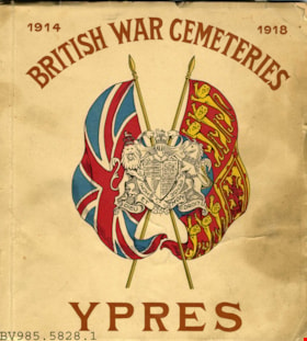
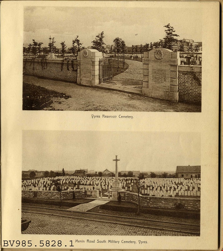
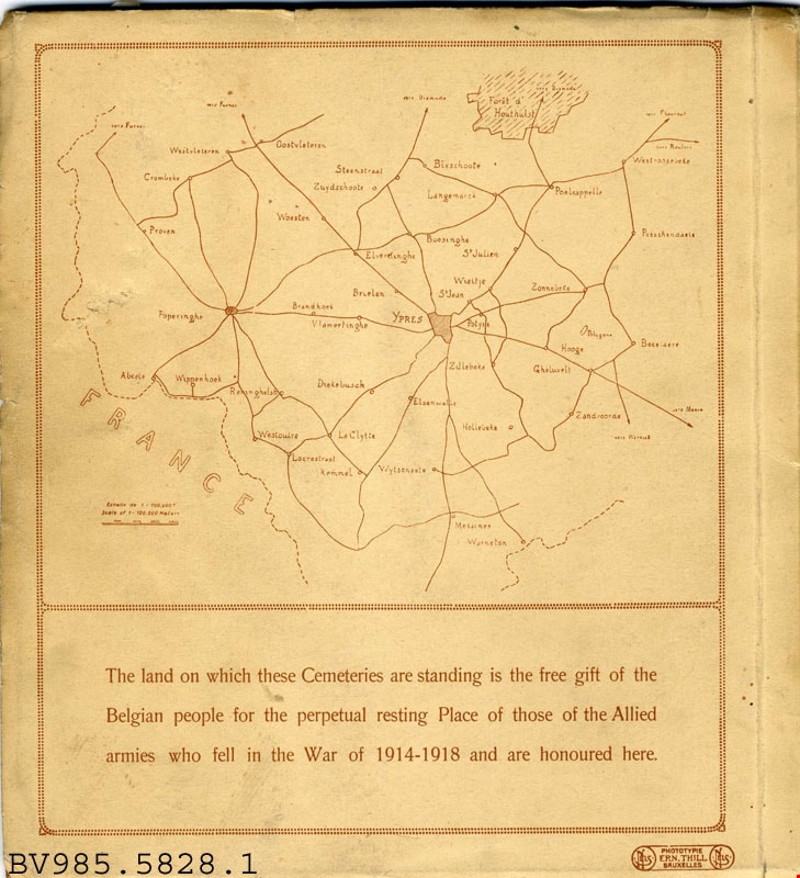
British war cemeteries Ypres : 1914-1918
https://search.heritageburnaby.ca/link/museumlibrary4927
- Repository
- Burnaby Village Museum
- Collection
- Special Collection
- Material Type
- Book
- Accession Code
- BV985.5828.1
- Call Number
- 940.3 BRI
- Place of Publication
- Bruxelles
- Publisher
- Ern. Thill
- Publication Date
- 1920
- Physical Description
- 1 v. (unpaged) : ill. : 21 cm.
- Library Subject (LOC)
- World War, 1914-1918--Monuments--Belgium--Ieper
- War memorials
- National cemeteries--Belgium--Ieper
- Monuments
- National cemeteries
- Soldiers' bodies, Disposition of
- Great Britain
Images

![1936 pillar, [1936] thumbnail](/media/hpo/_Data/_BVM_Images/1985/198557700001.jpg?width=280)
1936 pillar
https://search.heritageburnaby.ca/link/museumdescription1396
- Repository
- Burnaby Village Museum
- Date
- [1936]
- Collection/Fonds
- Burnaby Village Museum Photograph collection
- Description Level
- Item
- Physical Description
- 1 photograph : sepia ; 9.5 x 7 cm
- Scope and Content
- Photograph of a pillar topped by a circle with what appears to be a neon sign tubing writing out "1936". There is an insignia with two men on top of the circle [perhaps the Vancouver coat-of-arms]. As well, a Red Ensign and a Union Jack each hang from the pillar. Two streetcars and an apartment bui…
- Repository
- Burnaby Village Museum
- Collection/Fonds
- Burnaby Village Museum Photograph collection
- Description Level
- Item
- Physical Description
- 1 photograph : sepia ; 9.5 x 7 cm
- Material Details
- Decorative border printed around the photograph on recto
- Faint circular stamp mark of "Vancouver Drug Co." on verso, and gummed paper on each corner
- Stamp reads, "Come to Vancouver's Golden Jubilee 1936/ 50 Years of Progress" outside its circular seal for "Vancouver Drug/ Co. Ltd./ Nu-Gloss/ PHOTO FINISH"
- Scope and Content
- Photograph of a pillar topped by a circle with what appears to be a neon sign tubing writing out "1936". There is an insignia with two men on top of the circle [perhaps the Vancouver coat-of-arms]. As well, a Red Ensign and a Union Jack each hang from the pillar. Two streetcars and an apartment building are all visible in the background. The pillar is believed to be a commemorative pillar marking Vancouver's Golden Jubilee in 1936.
- Geographic Access
- Vancouver
- Accession Code
- BV985.5770.1
- Access Restriction
- No restrictions
- Reproduction Restriction
- No known restrictions
- Date
- [1936]
- Media Type
- Photograph
- Scan Resolution
- 600
- Scan Date
- 2024-02-02
- Notes
- Title based on contents of photograph
Images
![1936 pillar, [1936] thumbnail](/media/hpo/_Data/_BVM_Images/1985/198557700001.jpg)
![Archie and Dale in a cemetery, [2000] thumbnail](/media/hpo/_Data/_Archives_Images/_Unrestricted/535/535-2709-1.jpg?width=280)
Archie and Dale in a cemetery
https://search.heritageburnaby.ca/link/archivedescription97313
- Repository
- City of Burnaby Archives
- Date
- [2000]
- Collection/Fonds
- Burnaby NewsLeader photograph collection
- Description Level
- File
- Physical Description
- 4 photographs (tiff) : col.
- Scope and Content
- File contains photographs of two people, identified as Archie and Dale, in a cemetery. Photographs depict Archie and Dale looking at or posing with headstones and a close-up of an individual headstone.
- Repository
- City of Burnaby Archives
- Date
- [2000]
- Collection/Fonds
- Burnaby NewsLeader photograph collection
- Physical Description
- 4 photographs (tiff) : col.
- Description Level
- File
- Record No.
- 535-2709
- Access Restriction
- No restrictions
- Reproduction Restriction
- No restrictions
- Accession Number
- 2018-12
- Scope and Content
- File contains photographs of two people, identified as Archie and Dale, in a cemetery. Photographs depict Archie and Dale looking at or posing with headstones and a close-up of an individual headstone.
- Subjects
- Cemeteries
- Monuments - Gravestones
- Media Type
- Photograph
- Notes
- Title based on contents of file
- Collected by editorial for use in a September 2000 issue of the Burnaby NewsLeader
- Individuals identified by original file names of photographs
Images
![Archie and Dale in a cemetery, [2000] thumbnail](/media/hpo/_Data/_Archives_Images/_Unrestricted/535/535-2709-1.jpg)
![At the Vimy monument, [1945] thumbnail](/media/hpo/_Data/_BVM_Images/2000/200401040121.jpg?width=280)
At the Vimy monument
https://search.heritageburnaby.ca/link/museumdescription1826
- Repository
- Burnaby Village Museum
- Date
- [1945]
- Collection/Fonds
- Burnaby Village Museum Photograph collection
- Description Level
- Item
- Physical Description
- 1 photograph : b&w ; 8 x 5.5 cm
- Scope and Content
- Photograph of Frank Battersby standing in front of the Vimy monument (the Canadian National Vimy Memorial) dressed in his Seaforth Highlander uniform.
- Repository
- Burnaby Village Museum
- Collection/Fonds
- Burnaby Village Museum Photograph collection
- Description Level
- Item
- Physical Description
- 1 photograph : b&w ; 8 x 5.5 cm
- Material Details
- Photograph has scalloped edges
- Scope and Content
- Photograph of Frank Battersby standing in front of the Vimy monument (the Canadian National Vimy Memorial) dressed in his Seaforth Highlander uniform.
- Subjects
- Clothing - Military Uniforms
- Occupations - Military Personnel
- Monuments - War Memorials
- Wars - World War, 1914-1918
- Names
- Battersby, Frank
- Accession Code
- BV004.104.121
- Access Restriction
- No restrictions
- Date
- [1945]
- Media Type
- Photograph
- Scan Resolution
- 600
- Scan Date
- 09-Jun-09
- Scale
- 100
- Notes
- Title based on contents of photograph
- Note in black ink on verso of photograph reads: "Your soldier-boy in front of the Vimy monument."
Images
![At the Vimy monument, [1945] thumbnail](/media/hpo/_Data/_BVM_Images/2000/200401040121.jpg)
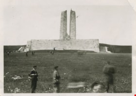
At Vimy Ridge monument
https://search.heritageburnaby.ca/link/museumdescription1841
- Repository
- Burnaby Village Museum
- Date
- 1945
- Collection/Fonds
- Burnaby Village Museum Photograph collection
- Description Level
- Item
- Physical Description
- 1 photograph : b&w ; 6 x 10.5 cm
- Scope and Content
- Photograph of uniformed soldiers scattered on a field around the Vimy Ridge monument in France. The soldier marked with an "X" is Frank Battersby (who has stopped to wait while "Tommy" lights his pipe).
- Repository
- Burnaby Village Museum
- Collection/Fonds
- Burnaby Village Museum Photograph collection
- Description Level
- Item
- Physical Description
- 1 photograph : b&w ; 6 x 10.5 cm
- Material Details
- Photograph has scalloped edges
- Scope and Content
- Photograph of uniformed soldiers scattered on a field around the Vimy Ridge monument in France. The soldier marked with an "X" is Frank Battersby (who has stopped to wait while "Tommy" lights his pipe).
- Subjects
- Monuments - War Memorials
- Clothing - Military Uniforms
- Occupations - Military Personnel
- Wars - World War, 1914-1918
- Wars - World War, 1939-1945
- Names
- Battersby, Frank
- Accession Code
- BV004.104.136
- Access Restriction
- No restrictions
- Date
- 1945
- Media Type
- Photograph
- Scan Resolution
- 600
- Scan Date
- 09-Jun-09
- Scale
- 100
- Notes
- Title based on contents of photograph
- Note in black ink on verso of photograph reads: "stopped while Tommy lite [sic] his pipe"
- Note in pencil on verso of photograph reads: "Vimy Ridge, France 1945 Frank Battersby is marked by 'X'. "
Images
Burnaby family gravestone
https://search.heritageburnaby.ca/link/archivedescription34659
- Repository
- City of Burnaby Archives
- Date
- 1959
- Collection/Fonds
- Burnaby Historical Society fonds
- Description Level
- Item
- Physical Description
- 1 photograph : b&w negative ; 12.6 x 9.9 cm
- Scope and Content
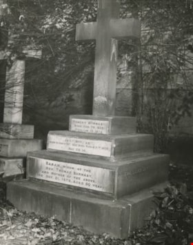
- Photograph of the Burnaby family's joint gravestone on the grounds of the Loughborough Emmanuel Parish Church (built 1835 to 1837). The top level of the stone reads, "Robert Burnaby / Born Nov 30 1828 : / Died Jan 10 1878." The next level reads, "Sarah Burnaby / Born October 22nd 1822 : Died March…
- Repository
- City of Burnaby Archives
- Date
- 1959
- Collection/Fonds
- Burnaby Historical Society fonds
- Subseries
- Photographs subseries
- Physical Description
- 1 photograph : b&w negative ; 12.6 x 9.9 cm
- Material Details
- "Ansco Safety Film 10" printed on edge of negative
- Description Level
- Item
- Record No.
- 084-001
- Access Restriction
- No restrictions
- Reproduction Restriction
- Reproduce for fair dealing purposes only
- Accession Number
- BHS2007-04
- Scope and Content
- Photograph of the Burnaby family's joint gravestone on the grounds of the Loughborough Emmanuel Parish Church (built 1835 to 1837). The top level of the stone reads, "Robert Burnaby / Born Nov 30 1828 : / Died Jan 10 1878." The next level reads, "Sarah Burnaby / Born October 22nd 1822 : Died March 2[?]th 1873 / Rev. VII 14." The bottom level reads, "Sarah, Widow of the Rev. Thomas Burnaby, / And Mother of the Above, / Died Oct. 31, 1878, Aged 89 Years." The side of the stone reads, "The Lord is My Shepherd."
- Subjects
- Monuments - Gravestones
- Names
- Burnaby, Robert
- Media Type
- Photograph
- Notes
- Title based on contents of photograph
- 1 b&w photograph accompanying
Images
![Burnaby family gravestones, [194-] thumbnail](/media/hpo/_Data/_BVM_Images/1976/1976_0065_0002_001.jpg?width=280)
Burnaby family gravestones
https://search.heritageburnaby.ca/link/museumdescription744
- Repository
- Burnaby Village Museum
- Date
- [194-]
- Collection/Fonds
- Burnaby Village Museum Photograph collection
- Description Level
- Item
- Physical Description
- 1 photograph : b&w ; 11.3 x 8.9 cm
- Scope and Content
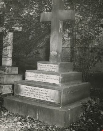
- Photograph of the grave marker for Robert Burnaby and other family members in Loughborough, United Kingdom. The grave marker is a cross on three tiered slabs with plaque on each. The top one reads, "Robert Burnaby / Born Nov. 30. 1828: Died Jan. 10.1878." The middle one reads, "Sarah Burnaby / Bo…
- Repository
- Burnaby Village Museum
- Collection/Fonds
- Burnaby Village Museum Photograph collection
- Description Level
- Item
- Physical Description
- 1 photograph : b&w ; 11.3 x 8.9 cm
- Scope and Content
- Photograph of the grave marker for Robert Burnaby and other family members in Loughborough, United Kingdom. The grave marker is a cross on three tiered slabs with plaque on each. The top one reads, "Robert Burnaby / Born Nov. 30. 1828: Died Jan. 10.1878." The middle one reads, "Sarah Burnaby / Born October 22. 1822: Died March 2 1875./ Rev. VII. 14." The bottom one reads, "Sarah, Widow of the / Rev. Thomas Burnaby, / And mother of the above. / Died: Oct. 31, 1878, Aged 80 Years."
- Subjects
- Monuments - Gravestones
- Accession Code
- HV976.65.2
- Access Restriction
- No restrictions
- Reproduction Restriction
- No known restrictions
- Date
- [194-]
- Media Type
- Photograph
- Related Material
- For a wider view of the grave marker, see HV976.65.3
- Scan Resolution
- 600
- Scan Date
- 2023-06-20
- Notes
- Title based on contents of photograph
- 1 b&w copy negative accompanying
Images
![Burnaby family gravestones, [194-] thumbnail](/media/hpo/_Data/_BVM_Images/1976/1976_0065_0002_001.jpg)
![Burnaby family gravestones, [194-] thumbnail](/media/hpo/_Data/_BVM_Images/1976/1976_0065_0003_001.jpg?width=280)
Burnaby family gravestones
https://search.heritageburnaby.ca/link/museumdescription745
- Repository
- Burnaby Village Museum
- Date
- [194-]
- Collection/Fonds
- Burnaby Village Museum Photograph collection
- Description Level
- Item
- Physical Description
- 1 photograph : b&w ; 11.4 x 8.9 cm
- Scope and Content
- Photograph of the grave marker for Robert Burnaby and other family members in cemetery in Loughborough, United Kingdom. The grave marker is a cross on three tiered slabs with plaque on each. The top one reads, "Robert Burnaby / Born Nov. 30. 1828: Died Jan. 10.1878." The middle one reads, "Sarah…
- Repository
- Burnaby Village Museum
- Collection/Fonds
- Burnaby Village Museum Photograph collection
- Description Level
- Item
- Physical Description
- 1 photograph : b&w ; 11.4 x 8.9 cm
- Scope and Content
- Photograph of the grave marker for Robert Burnaby and other family members in cemetery in Loughborough, United Kingdom. The grave marker is a cross on three tiered slabs with plaque on each. The top one reads, "Robert Burnaby / Born Nov. 30. 1828: Died Jan. 10.1878." The middle one reads, "Sarah Burnaby / Born October 22. 1822: Died March 2 1875./ Rev. VII. 14." The bottom one reads, "Sarah, Widow of the / Rev. Thomas Burnaby, / And mother of the above. / Died: Oct. 31, 1878, Aged 80 Years." It is suspected that the grave marker was located in the large church building that is shown in photo HV976.65.1. There is a brick wall behind the grave marker. Stamped on the back of the photo: "4387."
- Subjects
- Monuments - Gravestones
- Accession Code
- HV976.65.3
- Access Restriction
- No restrictions
- Reproduction Restriction
- No known restrictions
- Date
- [194-]
- Media Type
- Photograph
- Related Material
- For a closer view of the grave marker, see HV976.65.2
- Scan Resolution
- 600
- Scan Date
- 2023-06-20
- Notes
- Title based on contents of photograph
- 1 b&w copy negative accompanying
Images
![Burnaby family gravestones, [194-] thumbnail](/media/hpo/_Data/_BVM_Images/1976/1976_0065_0003_001.jpg)
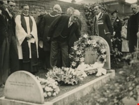
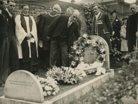
Ceremony at Vancouver's grave
https://search.heritageburnaby.ca/link/archivedescription36307
- Repository
- City of Burnaby Archives
- Date
- June 1, 1938
- Collection/Fonds
- Burnaby Historical Society fonds
- Description Level
- Item
- Physical Description
- 1 photograph : b&w ; 15.5 x 20 cm
- Scope and Content
- Photograph of the annual commemorative ceremony that takes place at Vancouver's grave in St. Peter’s churchyard in Petersham, England and is sponsored by the province of British Columbia.
- Repository
- City of Burnaby Archives
- Date
- June 1, 1938
- Collection/Fonds
- Burnaby Historical Society fonds
- Subseries
- George Grant subseries
- Physical Description
- 1 photograph : b&w ; 15.5 x 20 cm
- Description Level
- Item
- Record No.
- 243-027
- Access Restriction
- No restrictions
- Reproduction Restriction
- Reproduce for fair dealing purposes only
- Accession Number
- BHS1990-06
- Scope and Content
- Photograph of the annual commemorative ceremony that takes place at Vancouver's grave in St. Peter’s churchyard in Petersham, England and is sponsored by the province of British Columbia.
- Media Type
- Photograph
- Photographer
- Topical Press Agency Limited
- Notes
- Title based on contents of photograph
- Stamp on verso of photograph reads: "PHOTOGRAPH SUPPLIED BY THE TOPICAL PRESS LTD. 10-11, RED LION COURT FLEET STREET..LONDON, E.C.4."
Images
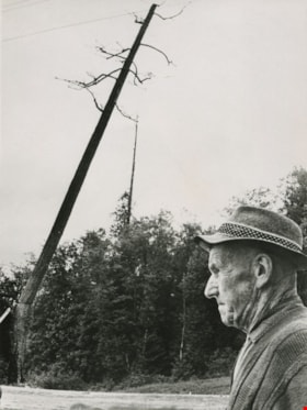
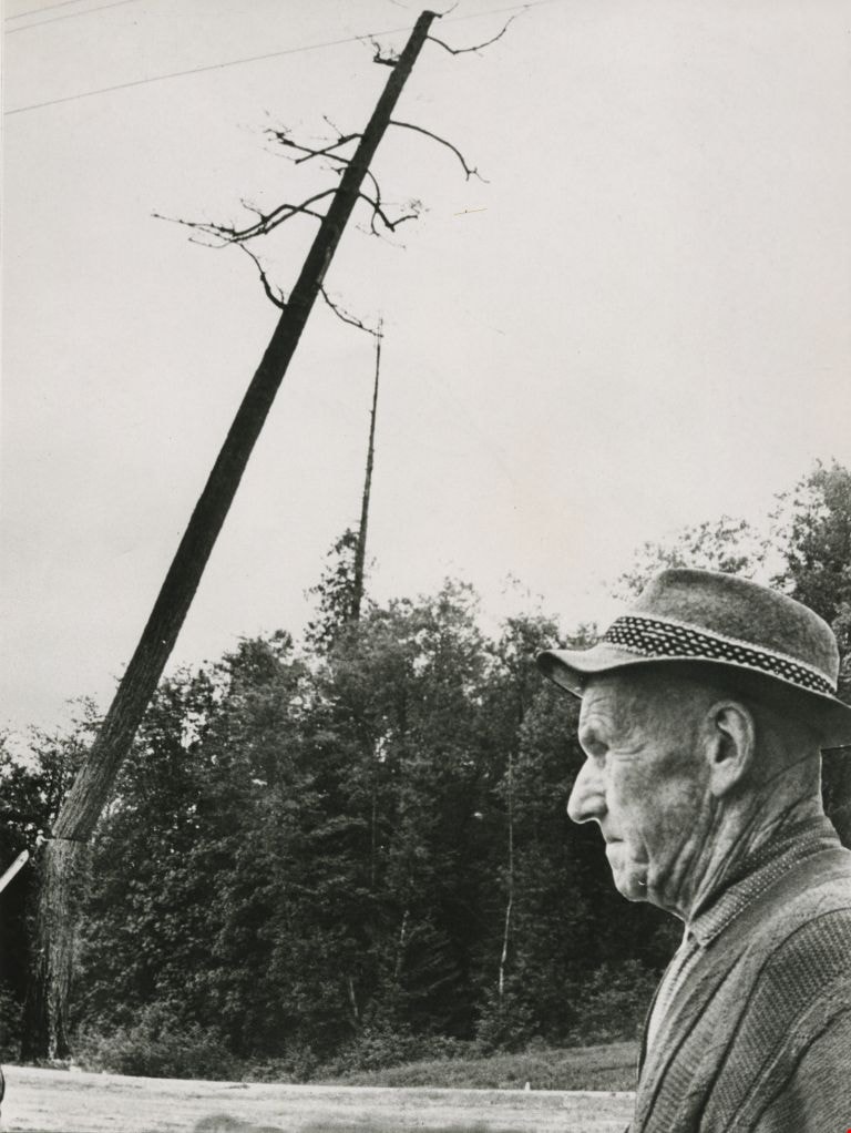
Charlie Perkins
https://search.heritageburnaby.ca/link/archivedescription46125
- Repository
- City of Burnaby Archives
- Date
- 1968
- Collection/Fonds
- Columbian Newspaper collection
- Description Level
- Item
- Physical Description
- 1 photograph : b&w photomontage ; 20 x 15 cm
- Scope and Content
- Photograph of World War I veteran Charlie Perkins watching as a "woodsman's saw" cuts down the tree that originally had been spared when the Port Mann freeway was built around it. (Charlie Perkins had planted ivy around the tree in 1920 as a memorial to his fallen comrades in the Royal Canadian Air…
- Repository
- City of Burnaby Archives
- Date
- 1968
- Collection/Fonds
- Columbian Newspaper collection
- Physical Description
- 1 photograph : b&w photomontage ; 20 x 15 cm
- Description Level
- Item
- Record No.
- 480-1013
- Access Restriction
- No restrictions
- Reproduction Restriction
- Reproduce for fair dealing purposes only
- Accession Number
- 2003-02
- Scope and Content
- Photograph of World War I veteran Charlie Perkins watching as a "woodsman's saw" cuts down the tree that originally had been spared when the Port Mann freeway was built around it. (Charlie Perkins had planted ivy around the tree in 1920 as a memorial to his fallen comrades in the Royal Canadian Air Force). A photograph of Charlie Perkins was collaged onto photograph of tree being felled, and then re-photographed to create this seamless montaged photograph.
- Names
- Perkins, Charlie
- Media Type
- Photograph
- Notes
- Title based on contents of photograph
Images