Narrow Results By
Subject
- Accidents 1
- Animals 1
- Animals - Birds 1
- Buildings - Commercial - Malls 1
- Buildings - Commercial - Train Stations 1
- Buildings - Residential - Houses 1
- Construction 1
- Construction Tools and Equipment 1
- Geographic Features - Automobile Parking Lots 1
- Geographic Features - Forests 1
- Geographic Features - Lakes and Ponds 1
- Geographic Features - Neighbourhoods 1
Metrotown: Burnaby Heritage Resource Inventory
https://search.heritageburnaby.ca/link/archivedescription98239
- Repository
- City of Burnaby Archives
- Date
- 1986
- Collection/Fonds
- Burnaby Historical Society fonds
- Description Level
- File
- Physical Description
- 4 cm of textual records and 171 photographs : col. and b&w ; 9 cm x 17 cm and smaller
- Scope and Content
- File contains the galley proof of "Metrotown: Burnaby Heritage Resource Inventory" published by the Burnaby Historical Society in Summer 1986. The publication text, captions, and photographs are adhered to the inventory's pages. File also contains an invoice and receipt from Budget Printing for 25…
- Repository
- City of Burnaby Archives
- Date
- 1986
- Collection/Fonds
- Burnaby Historical Society fonds
- Subseries
- Ephemera subseries
- Physical Description
- 4 cm of textual records and 171 photographs : col. and b&w ; 9 cm x 17 cm and smaller
- Description Level
- File
- Record No.
- MSS204-001
- Access Restriction
- No restrictions
- Reproduction Restriction
- May be restricted by third party rights
- Accession Number
- 2019-09
- Scope and Content
- File contains the galley proof of "Metrotown: Burnaby Heritage Resource Inventory" published by the Burnaby Historical Society in Summer 1986. The publication text, captions, and photographs are adhered to the inventory's pages. File also contains an invoice and receipt from Budget Printing for 25 copies of the publications.
- Subjects
- Buildings - Residential - Houses
- Media Type
- Textual Record
- Photograph
- Notes
- Title based on contents of file
- Historic Neighbourhood
- Central Park (Historic Neighbourhood)

Metrotown Station Square
https://search.heritageburnaby.ca/link/archivedescription93745
- Repository
- City of Burnaby Archives
- Date
- November 1989
- Collection/Fonds
- Grover, Elliott & Co. Ltd. fonds
- Description Level
- File
- Physical Description
- 83 photographs : col. negatives ; 35 mm + 2 computer disks ; 14 x 14 cm
- Scope and Content
- Photographs of Metrotown Station Square during construction. Businesses visible in the photographs include: Eastons, Holiday Inn, Future Shop, Great Canadian Superstore, and Toy City Consumers.
- Repository
- City of Burnaby Archives
- Date
- November 1989
- Collection/Fonds
- Grover, Elliott & Co. Ltd. fonds
- Physical Description
- 83 photographs : col. negatives ; 35 mm + 2 computer disks ; 14 x 14 cm
- Description Level
- File
- Record No.
- 622-030
- Access Restriction
- No restrictions
- Reproduction Restriction
- No restrictions
- Accession Number
- 2017-39
- Scope and Content
- Photographs of Metrotown Station Square during construction. Businesses visible in the photographs include: Eastons, Holiday Inn, Future Shop, Great Canadian Superstore, and Toy City Consumers.
- Media Type
- Photograph
- Notes
- Transcribed title
- Title transcribed from print envelopes photographs were originally housed in
- File no. 89-512-B
- Computer disks are labelled "Station Square Metro Town Nov /89". Computer disk envelopes are labelled "Suite 660-1380 Burrard ST / Van, BC"
- Geographic Access
- McKay Avenue
- Street Address
- 6200 McKay Avenue
- Historic Neighbourhood
- Central Park (Historic Neighbourhood)
- Planning Study Area
- Maywood Area
Images


Roof Collapse at Metrotown Save-on-Foods
https://search.heritageburnaby.ca/link/museumdescription1166
- Repository
- Burnaby Village Museum
- Date
- April 1988
- Collection/Fonds
- Burnaby Village Museum Photograph collection
- Description Level
- Item
- Physical Description
- 1 photograph : col. 19.5 x 24.5 cm
- Scope and Content
- Aerial photograph of the aftermath of the Save-on-Foods roof collapse at Metrotown on April 23, 1988. The rooftop parking lot has caved into the store along with the cars parked in that section. Workmen and police officers in uniforms are at the parking lot.
- Repository
- Burnaby Village Museum
- Collection/Fonds
- Burnaby Village Museum Photograph collection
- Description Level
- Item
- Physical Description
- 1 photograph : col. 19.5 x 24.5 cm
- Scope and Content
- Aerial photograph of the aftermath of the Save-on-Foods roof collapse at Metrotown on April 23, 1988. The rooftop parking lot has caved into the store along with the cars parked in that section. Workmen and police officers in uniforms are at the parking lot.
- Geographic Access
- Kingsway
- Street Address
- 4800 Kingsway
- Accession Code
- BV992.51.1
- Access Restriction
- Restricted access
- Reproduction Restriction
- May be restricted by third party rights
- Date
- April 1988
- Media Type
- Photograph
- Historic Neighbourhood
- Central Park (Historic Neighbourhood)
- Planning Study Area
- Maywood Area
- Scan Resolution
- 600
- Scan Date
- 01-Jun-09
- Scale
- 100
- Photographer
- Hodge, Craig
- Notes
- Title based on contents of photograph
Images

Evelyn Salisbury subseries
https://search.heritageburnaby.ca/link/archivedescription45
- Repository
- City of Burnaby Archives
- Date
- 1870 (date of original)-1991
- Collection/Fonds
- Burnaby Historical Society fonds
- Description Level
- Subseries
- Physical Description
- 2 m of textual records and other material
- Scope and Content
- Subseries consists of textual records and photographs that were collected by Lillian Evelyn Salisbury during her lifetime as a citizen of Burnaby. Records document historical sites and events in and related to Burnaby, as well as various heritage groups and events in British Columbia. Included in t…
- Repository
- City of Burnaby Archives
- Date
- 1870 (date of original)-1991
- Collection/Fonds
- Burnaby Historical Society fonds
- Subseries
- Evelyn Salisbury subseries
- Physical Description
- 2 m of textual records and other material
- Description Level
- Subseries
- Accession Number
- BHS1985-04
- BHS1985-15
- BHS1986-12
- BHS1986-25
- BHS1986-26
- BHS1987-04
- BHS1989-13
- BHS1989-18
- BHS1991-24
- Scope and Content
- Subseries consists of textual records and photographs that were collected by Lillian Evelyn Salisbury during her lifetime as a citizen of Burnaby. Records document historical sites and events in and related to Burnaby, as well as various heritage groups and events in British Columbia. Included in this subseries are the publication and papers related to "Metrotown - Burnaby Heritage Resource Inventory."
- History
- Lillian Evelyn "Evelyn" Salisbury was born in 1915 and moved to Burnaby in 1945. She had three children with her husband Fred: Gordon, Lorne, and Karen. While living in Burnaby, she worked with the Red Cross blood donor clinic and the Burnaby Health Unit. In 1958, she participated in the Greater Vancouver Health League’s campaign for fluoridation as the Health Chairman of the Burnaby Parent-Teacher Council. Evelyn Salisbury served two-year terms as secretary, vice-president and president of the Burnaby Historical Society and spearheaded a 1985 project to record Burnaby’s historical inventory of churches, schools, industries, homes and other pre-1930 buildings. When the building of Metrotown shopping centre threatened to clear historic homes in Central Park area, the Society produced a record of the historic buildings in the area. In 1988, as president of the Burnaby Historical Society, she convinced City of Burnaby aldermen to set up a heritage advisory committee. She was appointed to the Burnaby Centennial Committee the next year and in 1990 she was named Citizen of the Year by the Burnaby City Council. During her lifetime, Evelyn Salisbury endeavoured to collect papers of historical significance. She died in 1991.
- Media Type
- Textual Record
- Photograph
- Creator
- Salisbury, Evelyn
- Notes
- Title based on creator of subseries
- PC145, PC177, PC178, PC195, PC221, PC261, MSS061

Burnaby Lake slide show
https://search.heritageburnaby.ca/link/archivedescription91684
- Repository
- City of Burnaby Archives
- Date
- 1976-1999
- Collection/Fonds
- Doreen Lawson fonds
- Description Level
- File
- Physical Description
- 85 photographs : col. slides ; 35 mm
- Scope and Content
- File consists of photographs compiled by Doreen Lawson for slideshow presentations about Burnaby Lake. Slideshow primarily depicts the wildlife and foliage of Burnaby Lake, including: the painted turtle, heron, American coot, coyote, barn owl, rainbow fry, Canadian goose, and beaver, as well as a v…
- Repository
- City of Burnaby Archives
- Date
- 1976-1999
- Collection/Fonds
- Doreen Lawson fonds
- Physical Description
- 85 photographs : col. slides ; 35 mm
- Description Level
- File
- Record No.
- 618-002
- Access Restriction
- No restrictions
- Reproduction Restriction
- May be restricted by third party rights
- Accession Number
- 2015-15
- Scope and Content
- File consists of photographs compiled by Doreen Lawson for slideshow presentations about Burnaby Lake. Slideshow primarily depicts the wildlife and foliage of Burnaby Lake, including: the painted turtle, heron, American coot, coyote, barn owl, rainbow fry, Canadian goose, and beaver, as well as a variety of scenic photographs of the Burnaby Lake shoreline with mountains and the Metrotown skyline in distance. Also included in file are photographs of people canoeing, kayaking, feeding geese, and participating in conservation activities including fencing trees and testing water levels. Photographs also depict the pipeline leading into Burnaby Lake, lake dredging equipment, and an oil slick.
- Subjects
- Geographic Features - Lakes and Ponds
- Animals - Birds
- Animals
- Geographic Features - Forests
- Media Type
- Photograph
- Photographer
- Lawson, Doreen A.
- Notes
- Title based on contents of photographs
- Note in black ink on recto of slide sheet photographs 618-002-1 : 618-002-9 originally housed in read: "Burnby Lake Slideshow"
- Note in black ink on recto of slide sheet photographs 618-002-10 : 608-002-19 originally housed in read: "Burnaby Lake / Rejects (My Fav!)"
- Photographs contents are identified on many of the slide cases within the file.
- Historic Neighbourhood
- Burnaby Lake (Historic Neighbourhood)
- Planning Study Area
- Burnaby Lake Area
Images

Burnaby Public Library photograph subseries
https://search.heritageburnaby.ca/link/archivedescription58147
- Repository
- City of Burnaby Archives
- Date
- 1908-1973
- Collection/Fonds
- Burnaby Historical Society fonds
- Description Level
- Subseries
- Physical Description
- Photographs
- Scope and Content
- Subseries consists of historical photographs of Burnaby collected by the Burnaby Public Library.
- Repository
- City of Burnaby Archives
- Date
- 1908-1973
- Collection/Fonds
- Burnaby Historical Society fonds
- Physical Description
- Photographs
- Description Level
- Subseries
- Accession Number
- BHS1989-22
- Scope and Content
- Subseries consists of historical photographs of Burnaby collected by the Burnaby Public Library.
- History
- Burnaby's first library was founded in 1927 as the North Burnaby Library Association. Its first library building was established in 1935 on Hastings Street. In 1954, Burnaby enacted Bylaw No. 3522 to establish the Burnaby Public Library (BPL) and in 1957 BPL merged with the North Burnaby Library Association. BPL's first permanent library was the McGill branch, built in North Burnaby in 1961 and named after North Burnaby Library Association volunteer Grace McGill. Following McGill, BPL then established the Kingsway branch, Central Park branch, and Cameron branch. Central Park was replaced by the Bob Prittie Metrotown branch in 1991 and Kingsway with the Tommy Douglas branch in 2009.
- Media Type
- Photograph
- Creator
- Burnaby Public Library
- Notes
- PC225, PC226, PC227, PC228, PC229, PC230, PC231, PC232, PC322, and PC427
- Title based on creator of subseries
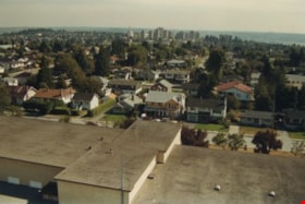
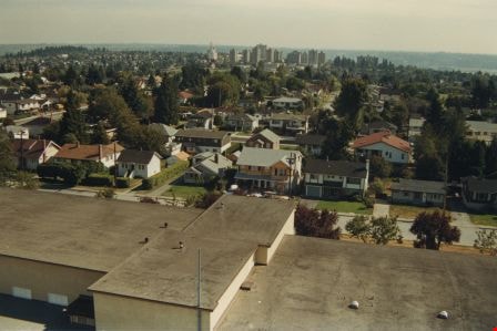
Edmonds school rooftop
https://search.heritageburnaby.ca/link/archivedescription35958
- Repository
- City of Burnaby Archives
- Date
- December 1987
- Collection/Fonds
- Burnaby Historical Society fonds
- Description Level
- Item
- Physical Description
- 1 photograph : col. ; 10 x 15 cm
- Scope and Content
- Photograph was taken looking south from a fire ladder above Edmonds Street School, with the school's rooftop as well as its surounding neighbourhood visible. Metrotown is in the distance.
- Repository
- City of Burnaby Archives
- Date
- December 1987
- Collection/Fonds
- Burnaby Historical Society fonds
- Subseries
- Edmonds School subseries
- Physical Description
- 1 photograph : col. ; 10 x 15 cm
- Description Level
- Item
- Record No.
- 207-007
- Access Restriction
- No restrictions
- Reproduction Restriction
- Reproduce for fair dealing purposes only
- Accession Number
- BHS1988-07
- Scope and Content
- Photograph was taken looking south from a fire ladder above Edmonds Street School, with the school's rooftop as well as its surounding neighbourhood visible. Metrotown is in the distance.
- Subjects
- Geographic Features - Neighbourhoods
- Media Type
- Photograph
- Notes
- Title based on contents of photograph
- Geographic Access
- 18th Avenue
- Street Address
- 7651 18th Avenue
- Historic Neighbourhood
- Edmonds (Historic Neighbourhood)
- Planning Study Area
- Edmonds Area
Images
Hazel L'Estrange subseries
https://search.heritageburnaby.ca/link/archivedescription58365
- Repository
- City of Burnaby Archives
- Date
- 1948-1965
- Collection/Fonds
- Burnaby Historical Society fonds
- Description Level
- Subseries
- Physical Description
- Textual records and photographs
- Scope and Content
- Subseries consists of records collected by Hazel L'Estrange. Records include documents pertaining to the namining of the Bob Prittie Metrotown branch, a minute book for the North Burnaby Committee on Radiation Hazards, and photographs of Simon Fraser University (SFU).
- Repository
- City of Burnaby Archives
- Date
- 1948-1965
- Collection/Fonds
- Burnaby Historical Society fonds
- Subseries
- Hazel L'Estrange subseries
- Physical Description
- Textual records and photographs
- Description Level
- Subseries
- Accession Number
- BHS1992-27
- BHS1991-10
- Scope and Content
- Subseries consists of records collected by Hazel L'Estrange. Records include documents pertaining to the namining of the Bob Prittie Metrotown branch, a minute book for the North Burnaby Committee on Radiation Hazards, and photographs of Simon Fraser University (SFU).
- Media Type
- Textual Record
- Photograph
- Creator
- L'Estrange, Hazel
- Notes
- Title based on creator of subseries
- MSS074, MSS052, PC248, PC372
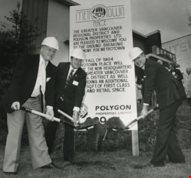
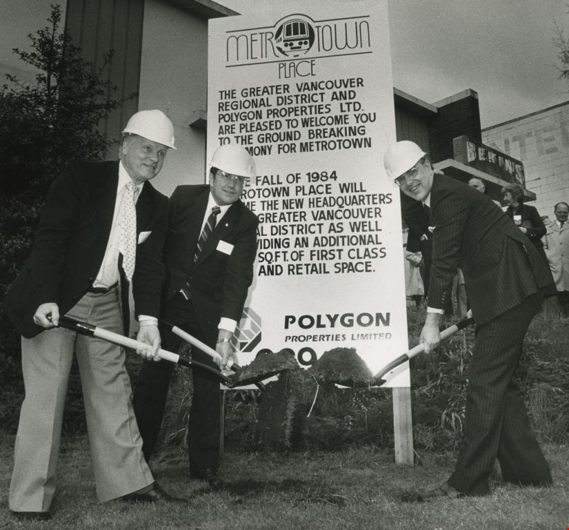
Mayor Bill Lewarne, Jim Tonn and Michael Audain
https://search.heritageburnaby.ca/link/archivedescription45386
- Repository
- City of Burnaby Archives
- Date
- 1983
- Collection/Fonds
- Columbian Newspaper collection
- Description Level
- Item
- Physical Description
- 1 photograph : b&w ; 19 x 20.5 cm
- Scope and Content
- Photograph of Burnaby Mayor Bill Lewarne, Jim Tonn from the Greater Vancouver Regional District (now Metro Vancouver), and the President of Polygon Michael Audain each with a shovel full of dirt at the ground breaking ceremony for Metrotown Place, the new headquaters for the Greater Vancouver Regio…
- Repository
- City of Burnaby Archives
- Date
- 1983
- Collection/Fonds
- Columbian Newspaper collection
- Physical Description
- 1 photograph : b&w ; 19 x 20.5 cm
- Description Level
- Item
- Record No.
- 480-281
- Access Restriction
- No restrictions
- Reproduction Restriction
- No restrictions
- Accession Number
- 2003-02
- Scope and Content
- Photograph of Burnaby Mayor Bill Lewarne, Jim Tonn from the Greater Vancouver Regional District (now Metro Vancouver), and the President of Polygon Michael Audain each with a shovel full of dirt at the ground breaking ceremony for Metrotown Place, the new headquaters for the Greater Vancouver Regional District (now Metro Vancouver).
- Media Type
- Photograph
- Photographer
- Battistoni, Peter
- Notes
- Title based on contents of photograph
- Geographic Access
- Kingsway
- Street Address
- 4330 Kingsway
- Historic Neighbourhood
- Central Park (Historic Neighbourhood)
- Planning Study Area
- Maywood Area
Images