Narrow Results By

Metrotown
https://search.heritageburnaby.ca/link/landmark817
- Repository
- Burnaby Heritage Planning
- Geographic Access
- Kingsway
- Associated Dates
- 1986
- Heritage Value
- Although the idea for Metrotown was first expressed in the 1970s, the building itself opened in 1986 and was soon served by the Expo Line of the new SkyTrain system. In the ensuing twenty years, the complex developed into three distinct but adjoining malls - Metropolis at Metrotown, Metrotown Centre, and Station Square. Today, Metrotown serves as the city’s commercial and retail anchor. The mall also includes two large office towers, which by 2001 were home to the head offices for Shaw Cable and TransLink.
- Historic Neighbourhood
- Central Park (Historic Neighbourhood)
- Planning Study Area
- Maywood Area
- Street Address
- 4700 Kingsway
- Street View URL
- Google Maps Street View
Images


Roof Collapse at Metrotown Save-on-Foods
https://search.heritageburnaby.ca/link/museumdescription1166
- Repository
- Burnaby Village Museum
- Date
- April 1988
- Collection/Fonds
- Burnaby Village Museum Photograph collection
- Description Level
- Item
- Physical Description
- 1 photograph : col. 19.5 x 24.5 cm
- Scope and Content
- Aerial photograph of the aftermath of the Save-on-Foods roof collapse at Metrotown on April 23, 1988. The rooftop parking lot has caved into the store along with the cars parked in that section. Workmen and police officers in uniforms are at the parking lot.
- Repository
- Burnaby Village Museum
- Collection/Fonds
- Burnaby Village Museum Photograph collection
- Description Level
- Item
- Physical Description
- 1 photograph : col. 19.5 x 24.5 cm
- Scope and Content
- Aerial photograph of the aftermath of the Save-on-Foods roof collapse at Metrotown on April 23, 1988. The rooftop parking lot has caved into the store along with the cars parked in that section. Workmen and police officers in uniforms are at the parking lot.
- Geographic Access
- Kingsway
- Street Address
- 4800 Kingsway
- Accession Code
- BV992.51.1
- Access Restriction
- Restricted access
- Reproduction Restriction
- May be restricted by third party rights
- Date
- April 1988
- Media Type
- Photograph
- Historic Neighbourhood
- Central Park (Historic Neighbourhood)
- Planning Study Area
- Maywood Area
- Scan Resolution
- 600
- Scan Date
- 01-Jun-09
- Scale
- 100
- Photographer
- Hodge, Craig
- Notes
- Title based on contents of photograph
Images

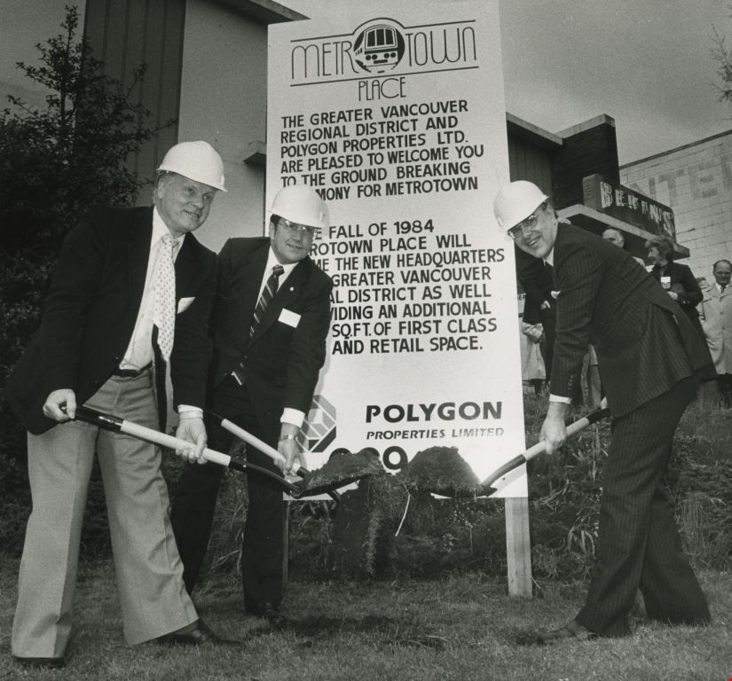
Mayor Bill Lewarne, Jim Tonn and Michael Audain
https://search.heritageburnaby.ca/link/archivedescription45386
- Repository
- City of Burnaby Archives
- Date
- 1983
- Collection/Fonds
- Columbian Newspaper collection
- Description Level
- Item
- Physical Description
- 1 photograph : b&w ; 19 x 20.5 cm
- Scope and Content
- Photograph of Burnaby Mayor Bill Lewarne, Jim Tonn from the Greater Vancouver Regional District (now Metro Vancouver), and the President of Polygon Michael Audain each with a shovel full of dirt at the ground breaking ceremony for Metrotown Place, the new headquaters for the Greater Vancouver Regio…
- Repository
- City of Burnaby Archives
- Date
- 1983
- Collection/Fonds
- Columbian Newspaper collection
- Physical Description
- 1 photograph : b&w ; 19 x 20.5 cm
- Description Level
- Item
- Record No.
- 480-281
- Access Restriction
- No restrictions
- Reproduction Restriction
- No restrictions
- Accession Number
- 2003-02
- Scope and Content
- Photograph of Burnaby Mayor Bill Lewarne, Jim Tonn from the Greater Vancouver Regional District (now Metro Vancouver), and the President of Polygon Michael Audain each with a shovel full of dirt at the ground breaking ceremony for Metrotown Place, the new headquaters for the Greater Vancouver Regional District (now Metro Vancouver).
- Media Type
- Photograph
- Photographer
- Battistoni, Peter
- Notes
- Title based on contents of photograph
- Geographic Access
- Kingsway
- Street Address
- 4330 Kingsway
- Historic Neighbourhood
- Central Park (Historic Neighbourhood)
- Planning Study Area
- Maywood Area
Images