Narrow Results By
Subject
- Buildings - Civic 1
- Buildings - Civic - Libraries 4
- Buildings - Commercial 4
- Buildings - Commercial - Cinemas 1
- Buildings - Commercial - Hotels and Motels 2
- Buildings - Commercial - Malls 3
- Buildings - Commercial - Service Stations 1
- Buildings - Commercial - Stores 2
- Buildings - Recreational - Bandstands 3
- Buildings - Recreational - Stadiums 2
- Buildings - Residential - Apartments 4
- Buildings - Residential - Houses 2
![24-hour relay at Swangard Stadium, [1999] thumbnail](/media/hpo/_Data/_Archives_Images/_Unrestricted/535/535-3231.jpg?width=280)
24-hour relay at Swangard Stadium
https://search.heritageburnaby.ca/link/archivedescription98153
- Repository
- City of Burnaby Archives
- Date
- [1999]
- Collection/Fonds
- Burnaby NewsLeader photograph collection
- Description Level
- Item
- Physical Description
- 1 photograph (tiff) : col.
- Scope and Content
- Photograph of a runner wearing a cow-spotted costume during a 24-hour relay race at Swangard Stadium. Other runners and participants with a banner are on the track behind the runner and many people are sitting in the stands in the background.
- Repository
- City of Burnaby Archives
- Date
- [1999]
- Collection/Fonds
- Burnaby NewsLeader photograph collection
- Physical Description
- 1 photograph (tiff) : col.
- Description Level
- Item
- Record No.
- 535-3231
- Access Restriction
- No restrictions
- Reproduction Restriction
- No restrictions
- Accession Number
- 2018-12
- Scope and Content
- Photograph of a runner wearing a cow-spotted costume during a 24-hour relay race at Swangard Stadium. Other runners and participants with a banner are on the track behind the runner and many people are sitting in the stands in the background.
- Names
- Swangard Stadium
- Media Type
- Photograph
- Notes
- Title based on contents of photograph
- Collected by editorial for use in a June 1999 issue of the Burnaby NewsLeader
- Geographic Access
- Central Park
- Imperial Street
- Street Address
- 3883 Imperial Street
- Historic Neighbourhood
- Central Park (Historic Neighbourhood)
- Planning Study Area
- Maywood Area
Images
![24-hour relay at Swangard Stadium, [1999] thumbnail](/media/hpo/_Data/_Archives_Images/_Unrestricted/535/535-3231.jpg)
4322-4342 Victory St
https://search.heritageburnaby.ca/link/archivedescription93770
- Repository
- City of Burnaby Archives
- Date
- August 1992
- Collection/Fonds
- Grover, Elliott & Co. Ltd. fonds
- Description Level
- File
- Physical Description
- 56 photographs : col. negatives ; 35 mm
- Scope and Content
- Photographs of the houses located between 4322-4342 Victory Street - addresses that no longer exist. The Skytrain Expo line is visible in the background of some photographs.
- Repository
- City of Burnaby Archives
- Date
- August 1992
- Collection/Fonds
- Grover, Elliott & Co. Ltd. fonds
- Physical Description
- 56 photographs : col. negatives ; 35 mm
- Description Level
- File
- Record No.
- 622-054
- Access Restriction
- No restrictions
- Reproduction Restriction
- No restrictions
- Accession Number
- 2017-39
- Scope and Content
- Photographs of the houses located between 4322-4342 Victory Street - addresses that no longer exist. The Skytrain Expo line is visible in the background of some photographs.
- Media Type
- Photograph
- Notes
- Transcribed title
- Title transcribed from envelope photographs were originally housed in
- File no. 92-304-B
- Geographic Access
- Victory Street
- Historic Neighbourhood
- Alta Vista (Historic Neighbourhood)
- Planning Study Area
- Maywood Area
4390 Grange Street, Bby [sic]
https://search.heritageburnaby.ca/link/archivedescription94319
- Repository
- City of Burnaby Archives
- Date
- September 1994
- Collection/Fonds
- Grover, Elliott & Co. Ltd. fonds
- Description Level
- File
- Physical Description
- 22 photographs : col. negatives ; 35 mm
- Scope and Content
- Photographs of the exterior of a high-rise apartment complex located at 4390 Grange Street.
- Repository
- City of Burnaby Archives
- Date
- September 1994
- Collection/Fonds
- Grover, Elliott & Co. Ltd. fonds
- Physical Description
- 22 photographs : col. negatives ; 35 mm
- Description Level
- File
- Record No.
- 622-104
- Access Restriction
- No restrictions
- Reproduction Restriction
- No restrictions
- Accession Number
- 2017-39
- Scope and Content
- Photographs of the exterior of a high-rise apartment complex located at 4390 Grange Street.
- Subjects
- Buildings - Residential - Apartments
- Media Type
- Photograph
- Notes
- Transcribed title
- Title transcribed from envelope photographs were originally housed in
- File no. 94-353-B
- Geographic Access
- Grange Street
- Street Address
- 4390 Grange Street
- Historic Neighbourhood
- Central Park (Historic Neighbourhood)
- Planning Study Area
- Maywood Area
5899 Wilson Ave.
https://search.heritageburnaby.ca/link/archivedescription94314
- Repository
- City of Burnaby Archives
- Date
- June 1994
- Collection/Fonds
- Grover, Elliott & Co. Ltd. fonds
- Description Level
- File
- Physical Description
- 20 photographs : col. negatives ; 35 mm
- Scope and Content
- Photographs of an undeveloped property located at 5899 Wilson Avenue and a tower under construction near the corner of Wilson Avenue and Kingsway.
- Repository
- City of Burnaby Archives
- Date
- June 1994
- Collection/Fonds
- Grover, Elliott & Co. Ltd. fonds
- Physical Description
- 20 photographs : col. negatives ; 35 mm
- Description Level
- File
- Record No.
- 622-099
- Access Restriction
- No restrictions
- Reproduction Restriction
- No restrictions
- Accession Number
- 2017-39
- Scope and Content
- Photographs of an undeveloped property located at 5899 Wilson Avenue and a tower under construction near the corner of Wilson Avenue and Kingsway.
- Media Type
- Photograph
- Notes
- Transcribed title
- Title transcribed from envelope photographs were originally housed in
- File no. 94-247-B
- Geographic Access
- Wilson Avenue
- Street Address
- 5899 Wilson Avenue
- Historic Neighbourhood
- Central Park (Historic Neighbourhood)
- Planning Study Area
- Maywood Area
5899 Wilson Ave
https://search.heritageburnaby.ca/link/archivedescription94320
- Repository
- City of Burnaby Archives
- Date
- October 1994
- Collection/Fonds
- Grover, Elliott & Co. Ltd. fonds
- Description Level
- File
- Physical Description
- 25 photographs : col. negatives ; 35 mm
- Scope and Content
- Photographs of a high-rise tower under construction at 5899 Wilson Avenue.
- Repository
- City of Burnaby Archives
- Date
- October 1994
- Collection/Fonds
- Grover, Elliott & Co. Ltd. fonds
- Physical Description
- 25 photographs : col. negatives ; 35 mm
- Description Level
- File
- Record No.
- 622-105
- Access Restriction
- No restrictions
- Reproduction Restriction
- No restrictions
- Accession Number
- 2017-39
- Scope and Content
- Photographs of a high-rise tower under construction at 5899 Wilson Avenue.
- Subjects
- Buildings - Residential - Apartments
- Media Type
- Photograph
- Notes
- Transcribed title
- Title transcribed from envelope photographs were originally housed in
- File no. 94-365-B
- Photographer identified as "J.C."
- Geographic Access
- Wilson Avenue
- Street Address
- 5899 Wilson Avenue
- Historic Neighbourhood
- Central Park (Historic Neighbourhood)
- Planning Study Area
- Maywood Area
6451 Telford Ave
https://search.heritageburnaby.ca/link/archivedescription94300
- Repository
- City of Burnaby Archives
- Date
- January 1994
- Collection/Fonds
- Grover, Elliott & Co. Ltd. fonds
- Description Level
- File
- Physical Description
- 22 photographs : col. negatives ; 35 mm
- Scope and Content
- Photographs of a self-storage business located at 6451 Telford Avenue - an address that no longer exists.
- Repository
- City of Burnaby Archives
- Date
- January 1994
- Collection/Fonds
- Grover, Elliott & Co. Ltd. fonds
- Physical Description
- 22 photographs : col. negatives ; 35 mm
- Description Level
- File
- Record No.
- 622-085
- Access Restriction
- No restrictions
- Reproduction Restriction
- No restrictions
- Accession Number
- 2017-39
- Scope and Content
- Photographs of a self-storage business located at 6451 Telford Avenue - an address that no longer exists.
- Subjects
- Buildings - Commercial
- Media Type
- Photograph
- Notes
- Transcribed title
- Title transcribed from envelope photographs were originally housed in
- File no. 94-011-B
- Photographer identified as "K.H."
- Geographic Access
- Telford Avenue
- Historic Neighbourhood
- Central Park (Historic Neighbourhood)
- Planning Study Area
- Maywood Area
6622 Willingdon Ave
https://search.heritageburnaby.ca/link/archivedescription93750
- Repository
- City of Burnaby Archives
- Date
- July 18, 1990
- Collection/Fonds
- Grover, Elliott & Co. Ltd. fonds
- Description Level
- File
- Physical Description
- 20 photographs : col. negatives ; 35 mm
- Scope and Content
- Photographs of the exterior of a three-storey apartment complex located at 6622 Willingdon Avenue and the surrounding area.
- Repository
- City of Burnaby Archives
- Date
- July 18, 1990
- Collection/Fonds
- Grover, Elliott & Co. Ltd. fonds
- Physical Description
- 20 photographs : col. negatives ; 35 mm
- Description Level
- File
- Record No.
- 622-035
- Access Restriction
- No restrictions
- Reproduction Restriction
- No restrictions
- Accession Number
- 2017-39
- Scope and Content
- Photographs of the exterior of a three-storey apartment complex located at 6622 Willingdon Avenue and the surrounding area.
- Media Type
- Photograph
- Notes
- Transcribed title
- Title transcribed from envelope photographs were originally housed in
- File no. 90V-002-B
- Geographic Access
- Willingdon Avenue
- Street Address
- 6622 Willingdon Avenue
- Historic Neighbourhood
- Central Park (Historic Neighbourhood)
- Planning Study Area
- Maywood Area
7641-7651 Royal Oak Ave
https://search.heritageburnaby.ca/link/archivedescription93769
- Repository
- City of Burnaby Archives
- Date
- July 30, 1992
- Collection/Fonds
- Grover, Elliott & Co. Ltd. fonds
- Description Level
- File
- Physical Description
- 25 photographs : col. negatives ; 35 mm
- Scope and Content
- Photographs of the commercial properties located between 7641 and 7651 Royal Oak Avenue. Stores visible in the photographs include: Buy Low Foods, Mega Movies, and Chevron service station.
- Repository
- City of Burnaby Archives
- Date
- July 30, 1992
- Collection/Fonds
- Grover, Elliott & Co. Ltd. fonds
- Physical Description
- 25 photographs : col. negatives ; 35 mm
- Description Level
- File
- Record No.
- 622-053
- Access Restriction
- No restrictions
- Reproduction Restriction
- No restrictions
- Accession Number
- 2017-39
- Scope and Content
- Photographs of the commercial properties located between 7641 and 7651 Royal Oak Avenue. Stores visible in the photographs include: Buy Low Foods, Mega Movies, and Chevron service station.
- Subjects
- Buildings - Commercial
- Buildings - Commercial - Service Stations
- Buildings - Commercial - Stores
- Geographic Features - Roads
- Media Type
- Photograph
- Photographer
- Young, Richard
- Notes
- Transcribed title
- Title transcribed from envelope photographs were originally housed in
- File no. 92-287-B
- Geographic Access
- Royal Oak Avenue
- Historic Neighbourhood
- Alta Vista (Historic Neighbourhood)
- Planning Study Area
- Maywood Area
Application for Assistance Transmission Line Undergrounding Grants Patterson Avenue Between Mayberry and Maywood Streets
https://search.heritageburnaby.ca/link/councilreport9808
- Repository
- City of Burnaby Archives
- Report ID
- 5614
- Meeting Date
- 8-Mar-1993
- Format
- Council - Manager's Report
- Manager's Report No.
- 15
- Item No.
- 10
- Collection/Fonds
- City Council and Office of the City Clerk fonds
- Repository
- City of Burnaby Archives
- Report ID
- 5614
- Meeting Date
- 8-Mar-1993
- Format
- Council - Manager's Report
- Manager's Report No.
- 15
- Item No.
- 10
- Collection/Fonds
- City Council and Office of the City Clerk fonds
Documents
![Brown family home, [199-] (date of original), digitally copied 2012 thumbnail](/media/hpo/_Data/_Archives_Images/_Unrestricted/540/549-020.jpg?width=280)
Brown family home
https://search.heritageburnaby.ca/link/archivedescription76900
- Repository
- City of Burnaby Archives
- Date
- [199-] (date of original), digitally copied 2012
- Collection/Fonds
- Community Heritage Commission Special Projects fonds
- Description Level
- Item
- Physical Description
- 1 photograph (jpeg) : col. ; 300ppi
- Scope and Content
- Photograph of Dennis and Cice Brown's house on Willingdon Avenue.
- Repository
- City of Burnaby Archives
- Date
- [199-] (date of original), digitally copied 2012
- Collection/Fonds
- Community Heritage Commission Special Projects fonds
- Physical Description
- 1 photograph (jpeg) : col. ; 300ppi
- Description Level
- Item
- Record No.
- 549-020
- Access Restriction
- No restrictions
- Reproduction Restriction
- Reproduce for fair dealing purposes only
- Accession Number
- 2012-30
- Scope and Content
- Photograph of Dennis and Cice Brown's house on Willingdon Avenue.
- Subjects
- Buildings - Residential - Houses
- Media Type
- Photograph
- Notes
- Title based on contents of photograph
- Geographic Access
- Willingdon Avenue
- Historic Neighbourhood
- Central Park (Historic Neighbourhood)
- Planning Study Area
- Maywood Area
Images
![Brown family home, [199-] (date of original), digitally copied 2012 thumbnail](/media/hpo/_Data/_Archives_Images/_Unrestricted/540/549-020.jpg)
Burnaby centennial anthology : stories of early Burnaby
https://search.heritageburnaby.ca/link/museumlibrary5472
- Repository
- Burnaby Village Museum
- Edition
- Rev. ed.
- Publication Date
- 1994
- Call Number
- 971.133 BUR COPY 3
- Repository
- Burnaby Village Museum
- Collection
- Digital Reference Collection
- Material Type
- Book
- ISBN
- 0969282826
- Call Number
- 971.133 BUR COPY 3
- Edition
- Rev. ed.
- Place of Publication
- Burnaby, B.C.
- Publisher
- City of Burnaby
- Publication Date
- 1994
- Physical Description
- 531 p. : ill. ; 28 cm.
- Library Subject (LOC)
- Burnaby (B.C.)--History
- Burnaby (B.C.)
- Biography
- Notes
- Includes index.
- 3 copies held: copy 3.
Digital Books
Burnaby's Bandstand
https://search.heritageburnaby.ca/link/archivedescription64773
- Repository
- City of Burnaby Archives
- Date
- January 1998
- Collection/Fonds
- Burnaby Historical Society fonds
- Description Level
- Item
- Physical Description
- 1 videocassette (unknown length)
- Scope and Content
- Item is a VHS tape entitled “Burnaby's Bandstand / Jan. 1998."
- Repository
- City of Burnaby Archives
- Date
- January 1998
- Collection/Fonds
- Burnaby Historical Society fonds
- Subseries
- Municipal record subseries
- Physical Description
- 1 videocassette (unknown length)
- Material Details
- Video Home System (VHS) tape
- Description Level
- Item
- Record No.
- 597-001
- Access Restriction
- No restrictions
- Reproduction Restriction
- May be restricted by third party rights
- Accession Number
- BHS2004-13
- Scope and Content
- Item is a VHS tape entitled “Burnaby's Bandstand / Jan. 1998."
- Media Type
- Moving Images
- Notes
- Continuation of title: "...Jan. 1998"
- Geographic Access
- Central Park
- Imperial Street
- Street Address
- 3883 Imperial Street
- Historic Neighbourhood
- Central Park (Historic Neighbourhood)
- Planning Study Area
- Maywood Area
Bylaw Number: 9820 - Capital Works, Machinery and Equipment Reserve Fund Expenditure Bylaw No 19, 1992
https://search.heritageburnaby.ca/link/bylaw14559
- Repository
- Legislative Services
- Bylaw Number
- 9820
- Final Adoption
- 1992 Dec 14
- Format
- Bylaws - Adopted
- Collection/Fonds
- City Council and Office of the City Clerk fonds
- Repository
- Legislative Services
- Bylaw Number
- 9820
- Final Adoption
- 1992 Dec 14
- Format
- Bylaws - Adopted
- Collection/Fonds
- City Council and Office of the City Clerk fonds
Documents
Catherine Rees
https://search.heritageburnaby.ca/link/archivedescription37179
- Repository
- City of Burnaby Archives
- Date
- November 14, 1992
- Collection/Fonds
- Burnaby Historical Society fonds
- Description Level
- Item
- Physical Description
- 1 photograph : col. ; 10 x 15 cm
- Scope and Content
- Photograph of Catherine Rees talking to a man inside the Metrotown Branch of the Burnaby Public Library.
- Repository
- City of Burnaby Archives
- Date
- November 14, 1992
- Collection/Fonds
- Burnaby Historical Society fonds
- Subseries
- Photographs subseries
- Physical Description
- 1 photograph : col. ; 10 x 15 cm
- Description Level
- Item
- Record No.
- 330-002
- Access Restriction
- In Archives only
- Reproduction Restriction
- Reproduce for fair dealing purposes only
- Accession Number
- BHS2007-04
- Scope and Content
- Photograph of Catherine Rees talking to a man inside the Metrotown Branch of the Burnaby Public Library.
- Subjects
- Buildings - Civic - Libraries
- Media Type
- Photograph
- Photographer
- Pel, Vera Rose Jackson
- Notes
- Title based on contents of photograph
- Geographic Access
- Willingdon Avenue
- Street Address
- 6100 Willingdon Avenue
- Historic Neighbourhood
- Central Park (Historic Neighbourhood)
- Planning Study Area
- Maywood Area
Catherine Rees and Gwen Pitman
https://search.heritageburnaby.ca/link/archivedescription37181
- Repository
- City of Burnaby Archives
- Date
- November 14, 1992
- Collection/Fonds
- Burnaby Historical Society fonds
- Description Level
- Item
- Physical Description
- 1 photograph : col. ; 15 x 10 cm
- Scope and Content
- Photograph of Catherine Rees standing with her hand resting on Gwen Pitman's chair, as she sits, with both hands resting on her cane at the Metrotown Branch of the Burnaby Public Library.
- Repository
- City of Burnaby Archives
- Date
- November 14, 1992
- Collection/Fonds
- Burnaby Historical Society fonds
- Subseries
- Photographs subseries
- Physical Description
- 1 photograph : col. ; 15 x 10 cm
- Description Level
- Item
- Record No.
- 330-004
- Access Restriction
- In Archives only
- Reproduction Restriction
- Reproduce for fair dealing purposes only
- Accession Number
- BHS2007-04
- Scope and Content
- Photograph of Catherine Rees standing with her hand resting on Gwen Pitman's chair, as she sits, with both hands resting on her cane at the Metrotown Branch of the Burnaby Public Library.
- Subjects
- Buildings - Civic - Libraries
- Media Type
- Photograph
- Photographer
- Pel, Vera Rose Jackson
- Notes
- Title based on contents of photograph
- Geographic Access
- Willingdon Avenue
- Street Address
- 6100 Willingdon Avenue
- Historic Neighbourhood
- Central Park (Historic Neighbourhood)
- Planning Study Area
- Maywood Area
![Clothes hangers in Metrotown hedges, [1999] thumbnail](/media/hpo/_Data/_Archives_Images/_Unrestricted/535/535-3388.jpg?width=280)
Clothes hangers in Metrotown hedges
https://search.heritageburnaby.ca/link/archivedescription98378
- Repository
- City of Burnaby Archives
- Date
- [1999]
- Collection/Fonds
- Burnaby NewsLeader photograph collection
- Description Level
- Item
- Physical Description
- 1 photograph (tiff) : col.
- Scope and Content
- Photograph of an unidentified person holding up clothes hangers with price tags and squatting in front of a hedge in the Metrotown area.
- Repository
- City of Burnaby Archives
- Date
- [1999]
- Collection/Fonds
- Burnaby NewsLeader photograph collection
- Physical Description
- 1 photograph (tiff) : col.
- Description Level
- Item
- Record No.
- 535-3388
- Access Restriction
- No restrictions
- Reproduction Restriction
- No restrictions
- Accession Number
- 2018-12
- Scope and Content
- Photograph of an unidentified person holding up clothes hangers with price tags and squatting in front of a hedge in the Metrotown area.
- Names
- Metrotown
- Media Type
- Photograph
- Notes
- Title based on original file name
- Collected by editorial for use in an October 1999 issue of the Burnaby NewsLeader
- Historic Neighbourhood
- Central Park (Historic Neighbourhood)
- Planning Study Area
- Maywood Area
Images
![Clothes hangers in Metrotown hedges, [1999] thumbnail](/media/hpo/_Data/_Archives_Images/_Unrestricted/535/535-3388.jpg)
Community Plan Area Two - Cul-de-sac on Maywood Street at Patterson Avenue
https://search.heritageburnaby.ca/link/councilreport12241
- Repository
- City of Burnaby Archives
- Report ID
- 12178
- Meeting Date
- 19-Feb-1990
- Format
- Council - Committee Report
- Collection/Fonds
- City Council and Office of the City Clerk fonds
- Repository
- City of Burnaby Archives
- Report ID
- 12178
- Meeting Date
- 19-Feb-1990
- Format
- Council - Committee Report
- Collection/Fonds
- City Council and Office of the City Clerk fonds
Documents
Community School Designation for Maywood Elementary School
https://search.heritageburnaby.ca/link/councilreport6381
- Repository
- City of Burnaby Archives
- Report ID
- 60751
- Meeting Date
- 26-May-1997
- Format
- Council - Manager's Report
- Manager's Report No.
- 15
- Item No.
- 2
- Collection/Fonds
- City Council and Office of the City Clerk fonds
- Repository
- City of Burnaby Archives
- Report ID
- 60751
- Meeting Date
- 26-May-1997
- Format
- Council - Manager's Report
- Manager's Report No.
- 15
- Item No.
- 2
- Collection/Fonds
- City Council and Office of the City Clerk fonds
Documents
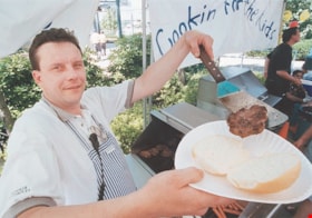
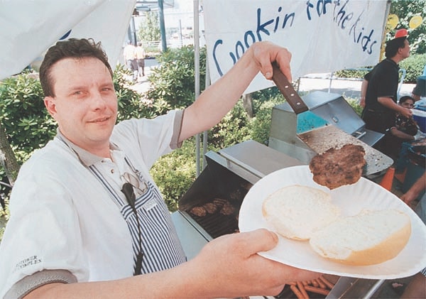
"Cookin for the Kids"
https://search.heritageburnaby.ca/link/archivedescription98197
- Repository
- City of Burnaby Archives
- Date
- [1999]
- Collection/Fonds
- Burnaby NewsLeader photograph collection
- Description Level
- Item
- Physical Description
- 1 photograph (tiff) : col.
- Scope and Content
- Photograph of an unidentified person, wearing a shirt that reads "Metrotower [illegible] Complex," cooking hamburgers at an outdoor charity event. A banner reading "Cookin for the Kids" is hanging behind the barbecues.
- Repository
- City of Burnaby Archives
- Date
- [1999]
- Collection/Fonds
- Burnaby NewsLeader photograph collection
- Physical Description
- 1 photograph (tiff) : col.
- Description Level
- Item
- Record No.
- 535-3275
- Access Restriction
- No restrictions
- Reproduction Restriction
- No restrictions
- Accession Number
- 2018-12
- Scope and Content
- Photograph of an unidentified person, wearing a shirt that reads "Metrotower [illegible] Complex," cooking hamburgers at an outdoor charity event. A banner reading "Cookin for the Kids" is hanging behind the barbecues.
- Subjects
- Events - Fundraising
- Occupations - Cooks
- Media Type
- Photograph
- Notes
- Title based on contents of photograph
- Collected by editorial for use in an August 1999 issue of the Burnaby NewsLeader
- Geographic Access
- Kingsway
- Historic Neighbourhood
- Central Park (Historic Neighbourhood)
- Planning Study Area
- Maywood Area
Images
![Crystal Ballroom at the Hilton Hotel, [1999] thumbnail](/media/hpo/_Data/_Archives_Images/_Unrestricted/535/535-3362.jpg?width=280)
Crystal Ballroom at the Hilton Hotel
https://search.heritageburnaby.ca/link/archivedescription98352
- Repository
- City of Burnaby Archives
- Date
- [1999]
- Collection/Fonds
- Burnaby NewsLeader photograph collection
- Description Level
- Item
- Physical Description
- 1 photograph (tiff) : col.
- Scope and Content
- Photograph of Simon Mais, the Assistant General Manager of the new Hilton Hotel at the Crystal in the Metrotown area, posing in the hotel's Crystal Ballroom. Other Metrotown towers and a crane are visible in the view in the background.
- Repository
- City of Burnaby Archives
- Date
- [1999]
- Collection/Fonds
- Burnaby NewsLeader photograph collection
- Physical Description
- 1 photograph (tiff) : col.
- Description Level
- Item
- Record No.
- 535-3362
- Access Restriction
- No restrictions
- Reproduction Restriction
- No restrictions
- Accession Number
- 2018-12
- Scope and Content
- Photograph of Simon Mais, the Assistant General Manager of the new Hilton Hotel at the Crystal in the Metrotown area, posing in the hotel's Crystal Ballroom. Other Metrotown towers and a crane are visible in the view in the background.
- Names
- Metrotown
- Media Type
- Photograph
- Photographer
- Bartel, Mario
- Notes
- Title based on caption
- Collected by editorial for use in an October 1999 issue of the Burnaby NewsLeader
- Caption from metadata: "Simon Mais, the Assistant General Manager at the new Hilton Hotel at the Crystal, enjoys the view from the Crystal Ballroom."
- Geographic Access
- McKay Avenue
- Street Address
- 6083 McKay Avenue
- Historic Neighbourhood
- Central Park (Historic Neighbourhood)
- Planning Study Area
- Maywood Area
Images
![Crystal Ballroom at the Hilton Hotel, [1999] thumbnail](/media/hpo/_Data/_Archives_Images/_Unrestricted/535/535-3362.jpg)