Narrow Results By

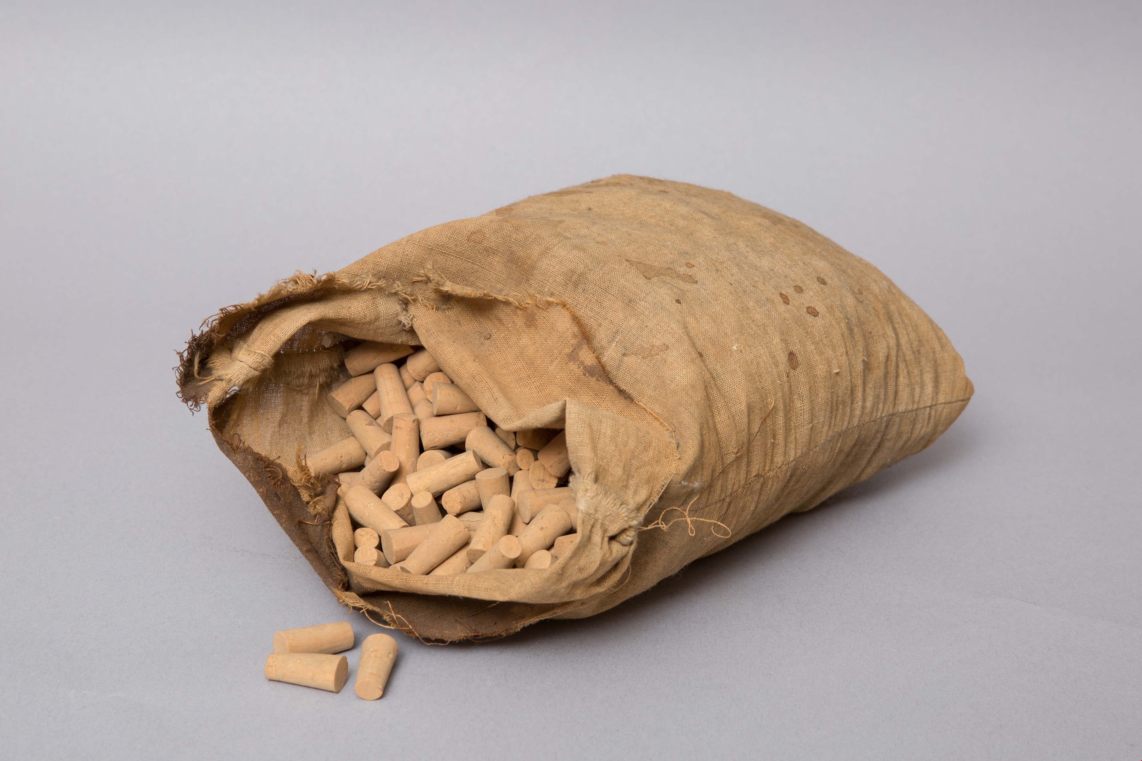
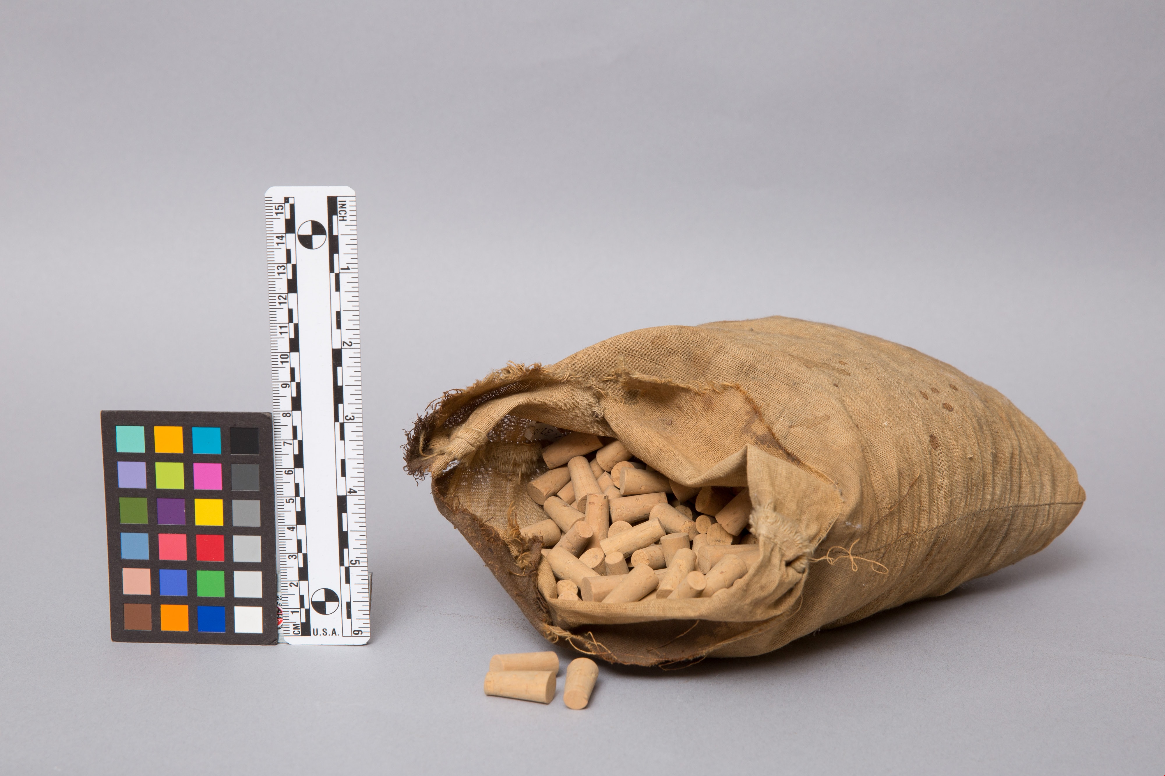
bag of corks
https://search.heritageburnaby.ca/link/museumartifact1328
- Repository
- Burnaby Village Museum
- Accession Code
- HV971.37.106
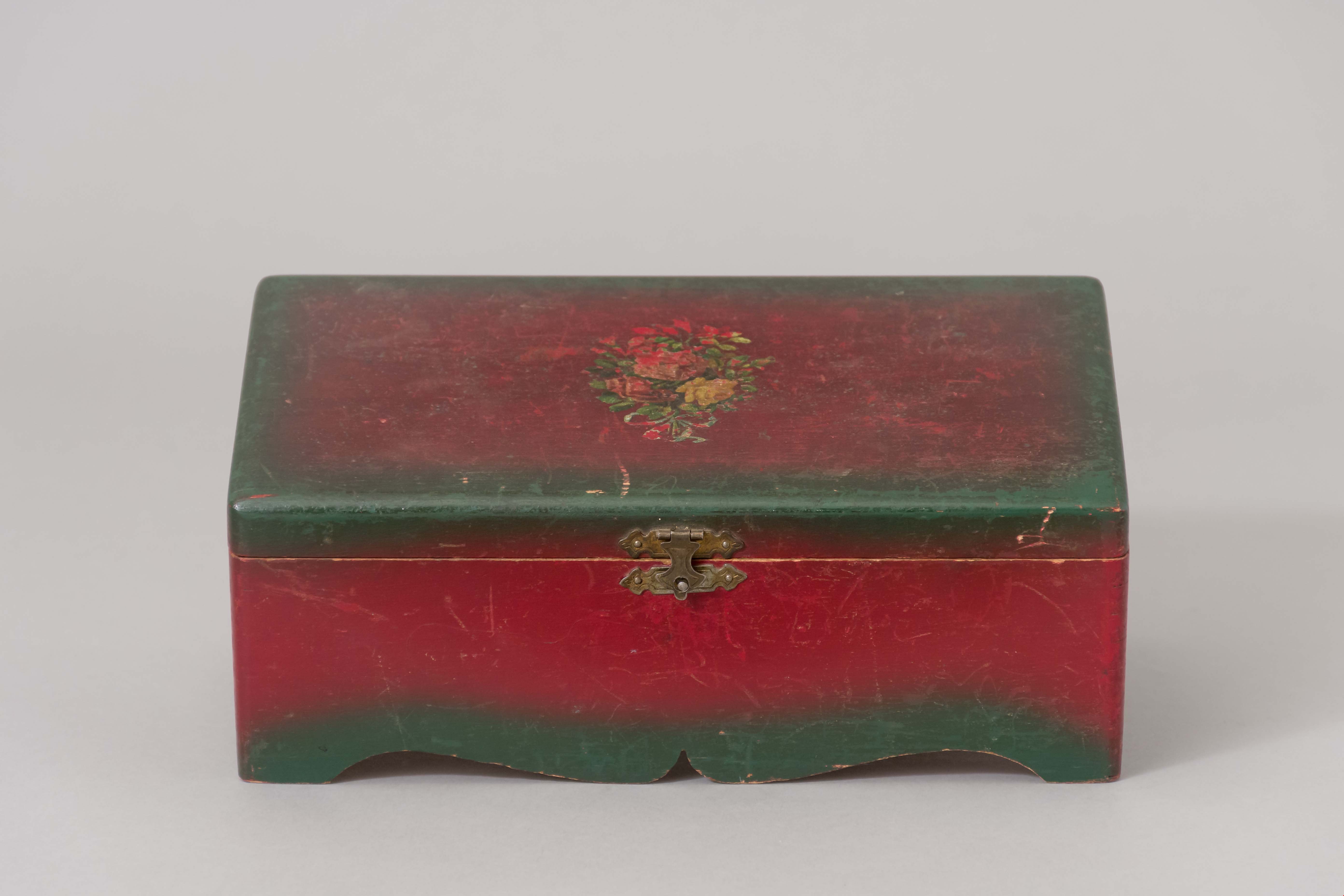
- Description
- Beige, flour sack-type cloth bag filled with unused corks. Open at top. Stitching along sides. Some stains on cloth.
- Object History
- This item originates from the Central Park Pharmacy in Burnaby.
- Classification
- Chemical T&E
- Marks/Labels
- no label found
- Names
- Central Park Pharmacy
- Geographic Access
- Central Park
- Historic Neighbourhood
- Central Park (Historic Neighbourhood)
- Planning Study Area
- Maywood Area
Images
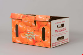
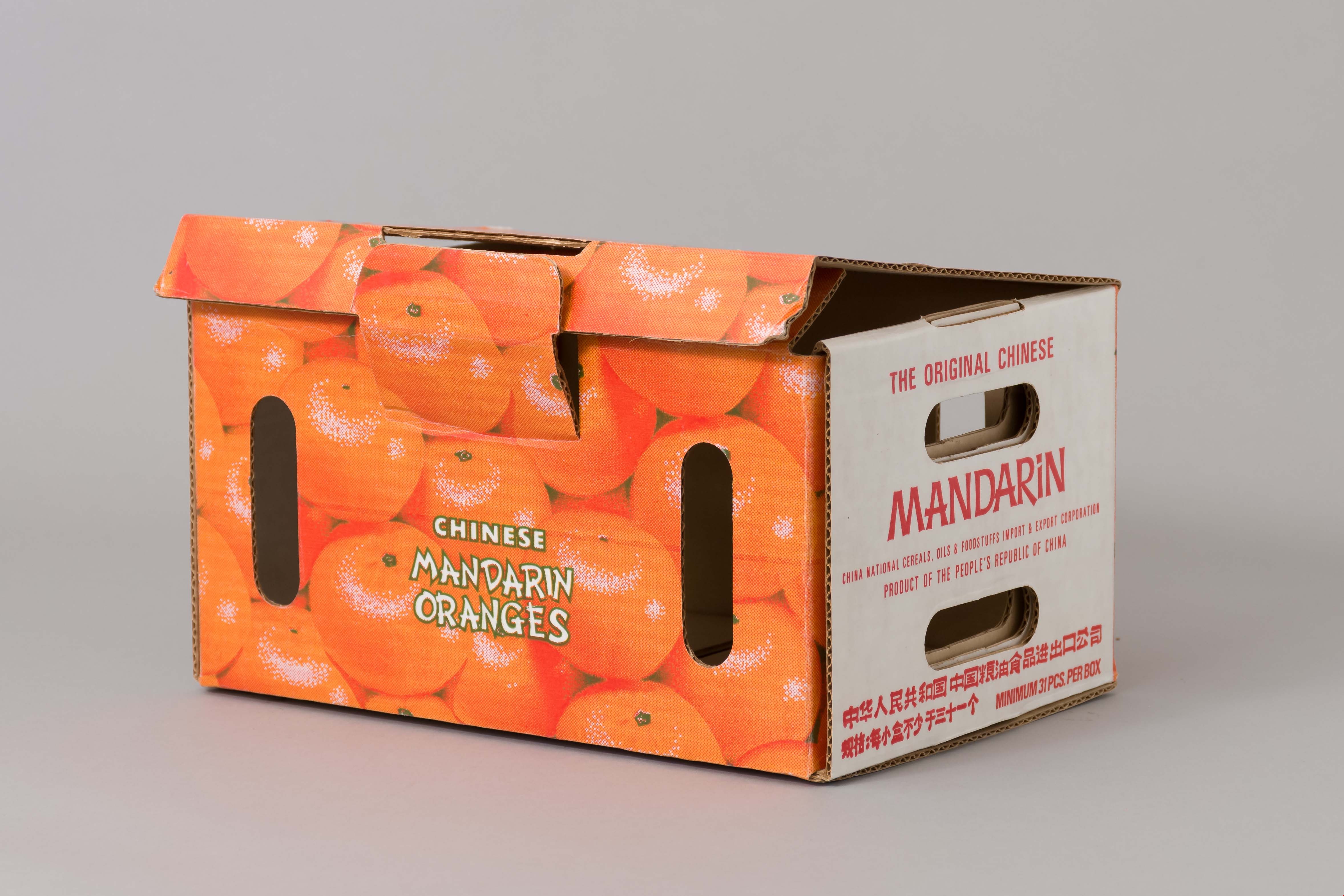
Box
https://search.heritageburnaby.ca/link/museumartifact89918
- Repository
- Burnaby Village Museum
- Accession Code
- BV019.6.1
- Description
- box; to ship and sell mandarin oranges; rectangular, corrugated cardboard box; single piece of cardboard, folded to form box; locking tab lid; oval cut outs in sides and lid for air circulation and for carrying; interior is plain brown cardboard; exterior has white, orange, and green text and illustrations beneath a wax coating. Colourful illustrations of mandarin oranges on sides and lid of box; text on front, back, and lid reads: "CHINESE / MANDARIN / ORANGES"; text on one side in French and other side in English reads: "THE ORIGINAL CHINESE / MANDARIN / CHINA NATIONAL CEREALS, OILS & FOODSTUFFS IMPORT & EXPORT CORPORATION / PRODUCT OF THE PEOPLE'S REPUBLIC OF CHINA / [text in Chinese] / MINIMUM 31 PCS. PER BOX"."
- Object History
- As a produce buyer for Kelly Douglas, Cecil Lee worked closely with local farmers along Marine Drive and in the Fraser Valley. The Burnaby company was one of the largest food distributors in Canada. In the mid-1970s, Lee was asked to oversee the import of Chinese mandarin oranges into Canada. Until that time, mandarin oranges had come from Japan and were sold in the winter, especially at Christmas. When the Japanese market could no longer keep up with demand, Kelly Douglas looked to China. The company relied on Lee’s cultural knowledge to build this very profitable part of their business. Lee designed the cardboard Chinese mandarin orange box to replace wooden containers. The iconic design required no glue or staples, making it possible for farmers to assemble and pack the boxes as they picked the oranges.
- Reference
- For other records in this collection see: Business records series of Julie Lee and Cecil Lee family fonds
- Category
- 04.Tools & Equipment for Materials
- Classification
- Food Processing & Preparation T&E - - Food Storage Equipment
- Object Term
- Box, Food Storage
- Subjects
- Agriculture - Fruit and Berries
- Container - Box
- Occupations - Agricultural Labourers
- Occupations - Grocers
- Names
- Lee, Julie Cho Chan
- Historic Neighbourhood
- Central Park (Historic Neighbourhood)
- Planning Study Area
- Maywood Area
Images
Bumper
https://search.heritageburnaby.ca/link/museumartifact9714
- Repository
- Burnaby Village Museum
- Accession Code
- BV985.2075.1
- Description
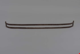
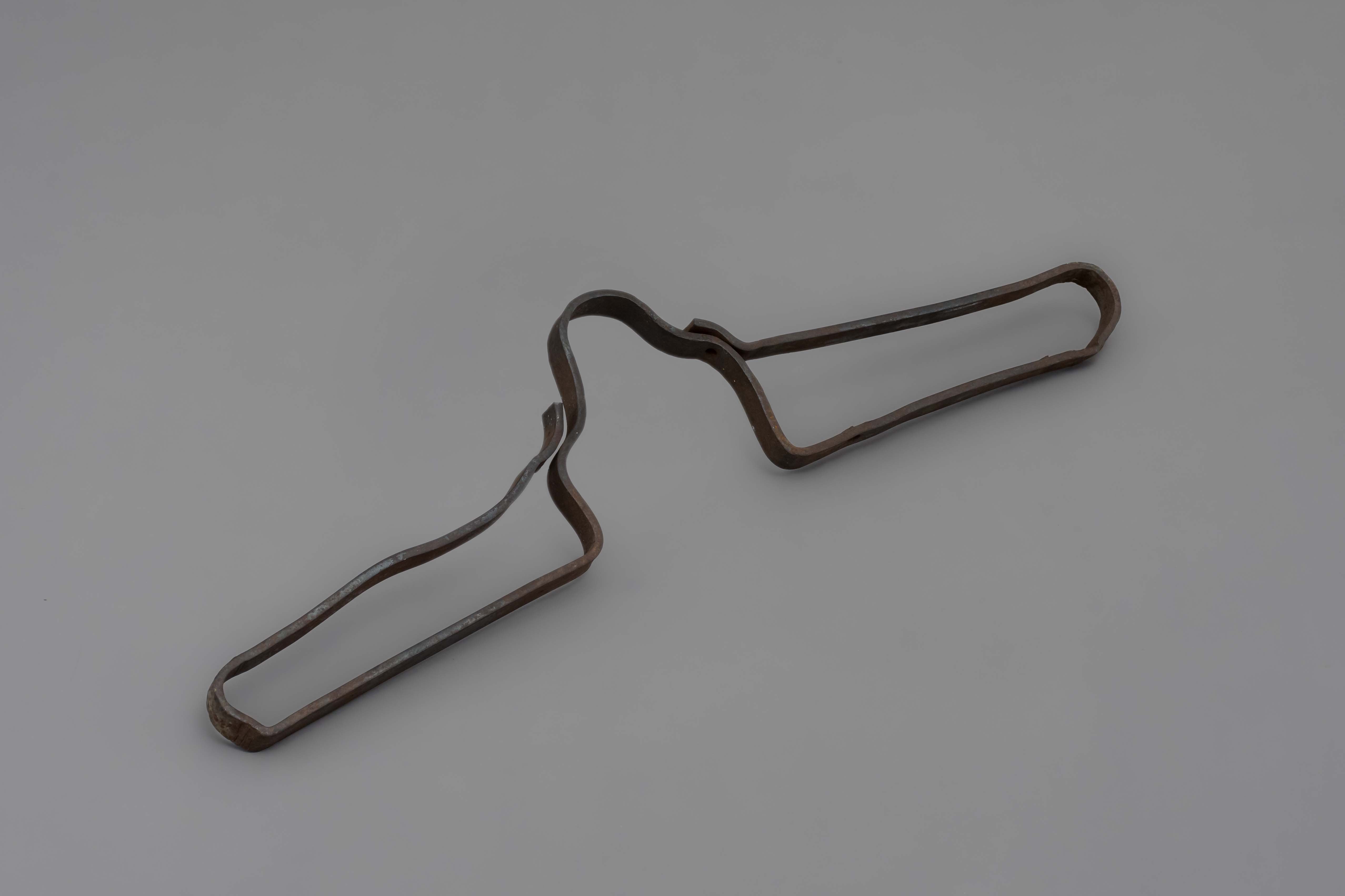
- Chevy bumper for automobile, rusted.
- Object History
- Bumper of this type was sold at Wagner's shop in his fleet of bumpers but was not the style he patented. This item can be seen in the blacksmith's shop at Burnaby Village Museum.
- Subjects
- Transportation - Automobiles
- Names
- Wagner, Frank
- Historic Neighbourhood
- Central Park (Historic Neighbourhood)
- Planning Study Area
- Maywood Area
Images
bumper
https://search.heritageburnaby.ca/link/museumartifact89937
- Repository
- Burnaby Village Museum
- Accession Code
- BV019.4.1
- Description
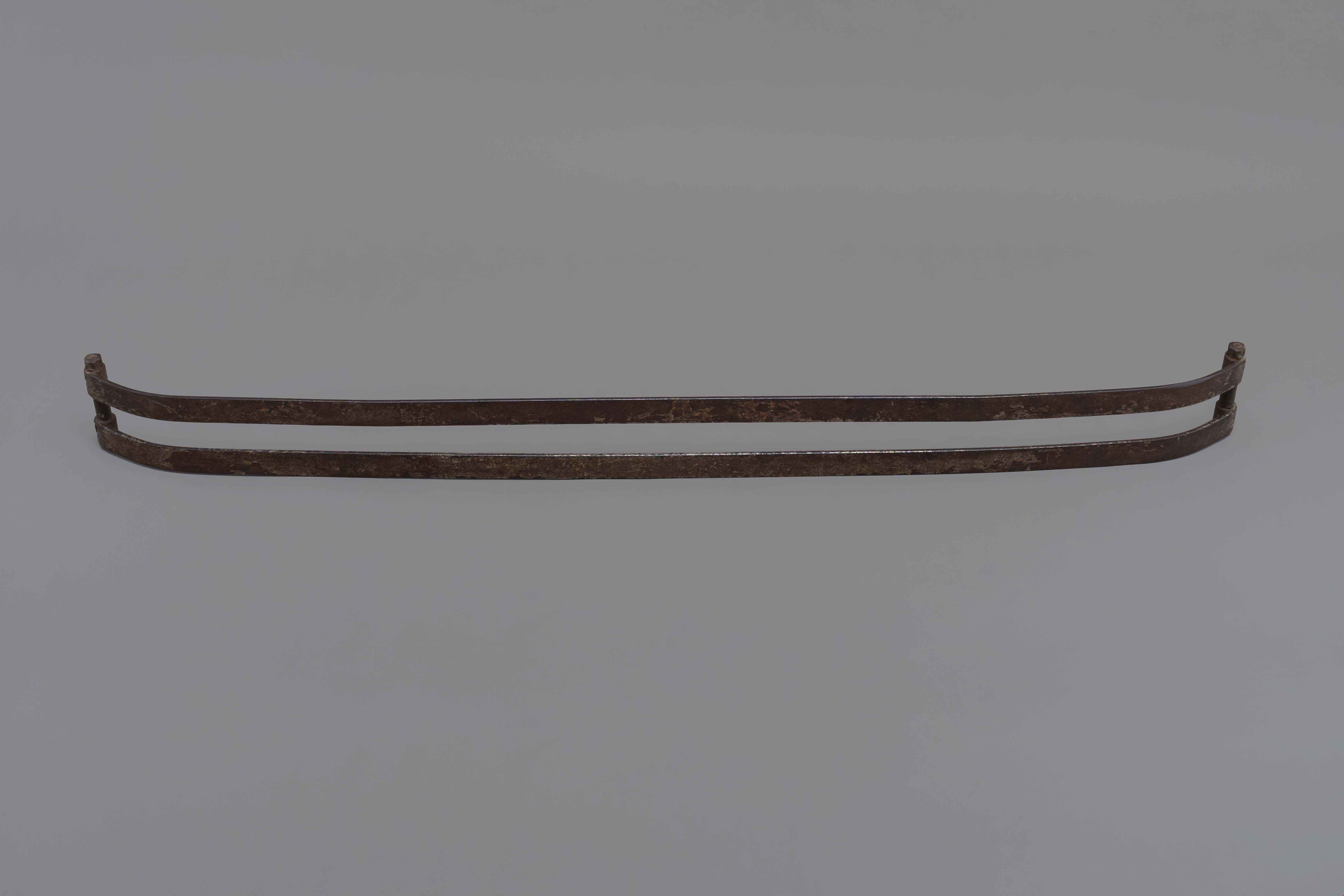
- Replica Wagner bumper made by blacksmiths at BVM
- Object History
- This is a replica of a Wagner bumper. Frank Wagner patented his Triple Spring Bumper for automobiles and attempted to interest one of the major automobile manufacturers in purchasing his patent. He manufactured some bumpers and sold them locally.
- Classification
- Land Transportation T&E - - Land Transportation Accessories
- Object Term
- Fender, Vehicle
- Names
- Wagner, Frank
- Historic Neighbourhood
- Central Park (Historic Neighbourhood)
- Planning Study Area
- Maywood Area
Images
christmas lights in package
https://search.heritageburnaby.ca/link/museumartifact35607
- Repository
- Burnaby Village Museum
- Accession Code
- BV993.53.20
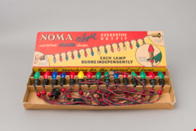
- Description
- String of 15 Christmas tree lights, with cardboard holder and box; lights have patented bead holding lamps in position on tree, and connector on one end of string to plug in additional strings; holder keeps lights in place during storage; lid of box says, "NOMA" "15 Light DECORATIVE OUTFIT" "with 120 Volt MAZDA Lamps"; lid is red and yellow, string of coloured lights sep- arating sections; circle with enlarged bulb, "PATENTED BEAD..."; "EACH LAMP BURNS INDEPENDENTLY"; around edges, "No more searching..."; one end, "CAT. No. 3415"; three corners broken, "Price 5.50 ea." on lid in crayon
- Object History
- These items are from the Bailey family home at 6080 Kathleen Street (built in 1922) in the Central Park area. The lights are circa 1950s.
- Classification
- Lighting Equipment - - Lighting Devices
- Object Term
- Light, String
- Subjects
- Holidays - Christmas
- Lighting Devices
- Historic Neighbourhood
- Central Park (Historic Neighbourhood)
- Planning Study Area
- Maywood Area
Images


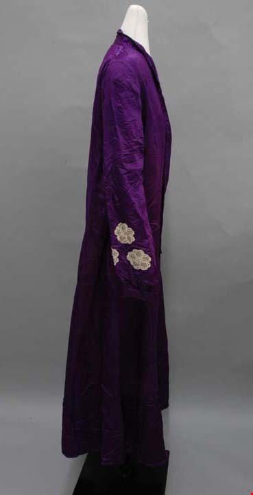
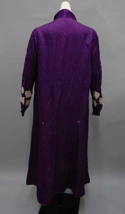
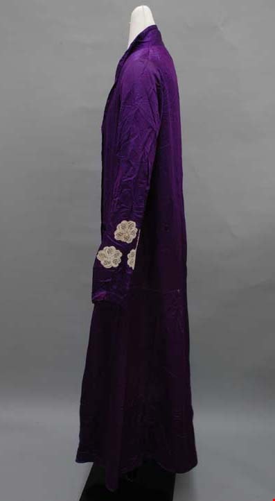
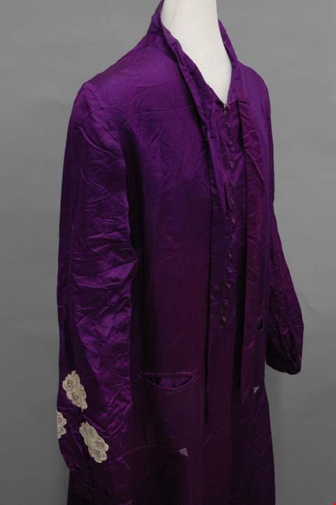
dress
https://search.heritageburnaby.ca/link/museumartifact46563
- Repository
- Burnaby Village Museum
- Accession Code
- BV004.21.6
- Description
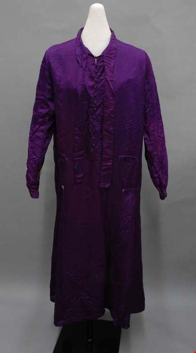
- Dress, c.1920. Purple silk satin with lace applique on sleeves. High collar with bow, buttons centre front, slightly flared ankle length skirt. Bias side panels on skirt. This dress seems characteristic of an item that would appeal to its particular owner. Born in 1880, she is following 1920s trends somewhat with the straight cut and bias skirt inserts, but also staying true to the fashion of her youth that she is comfortable with: a high collar, longer skirt, scarf, and lace applique are all borrowed from her time in the belle epoque. Extending from the stand collar are two long ties that could be tied into a bow or square knot. Directly under this at centre front is the opening with thirteen self fabric covered buttons. There is a bust dart on each side front, and a welt pocket on each side front just above the hips. At a dropped waist, there is a somewhat flared gore on each side of the skirt that extends from side front to back. The skirt extends to just above the ankles, with a small double fold hem. Inside, the dress is unlined; its seams are finished with a whip stitch. The garment was likely made by its owner.
- Object History
- Object was inherited by the donor ca. 1974. She was given it by her mother, who had inherited it from her own mother, Elizabeth (Babb) Heaney.
- Colour
- Purple
- Subjects
- Clothing
- Clothing - Costumes
- Historic Neighbourhood
- Central Park (Historic Neighbourhood)
- Planning Study Area
- Maywood Area
Images
.jpg)
dress
https://search.heritageburnaby.ca/link/museumartifact46564
- Repository
- Burnaby Village Museum
- Accession Code
- BV004.21.7
- Description
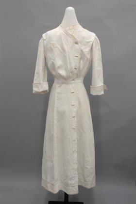
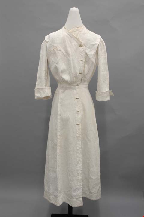
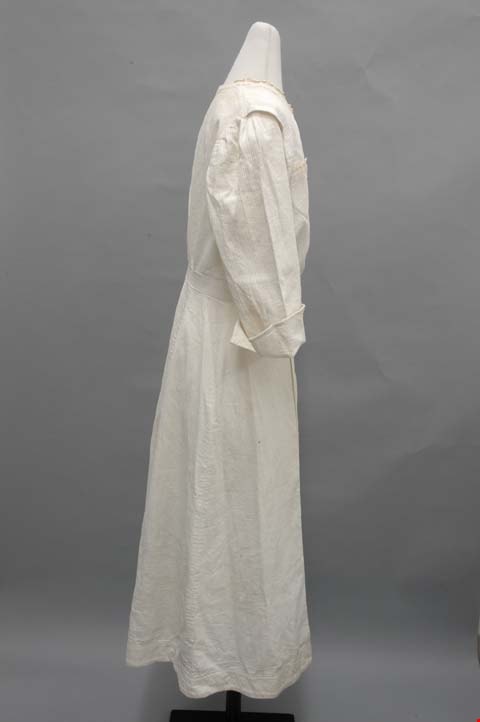
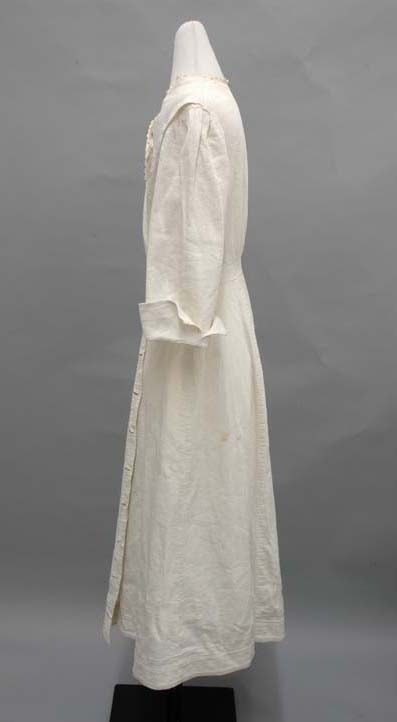
- Dress, c.1914-1918. White cotton pique. Calf length, three quarter length sleeves, buttons down centre front and up to neckline, waistband and cuffs. The tight collar is edged with a scalloped trim; the right side of the collar extends diagonally to the right, making a slight V neck, and turns down the centre front. The trim follows the line to the waistband. At each shoulder just before the sleeve, there is a pleat that opens up. On the front at the waistband, there is some gathering in the waistband, and some small pleats at centre back. On the bodice front right, there is a small pocket that ends in a triangle shape and is topped with scalloped edging. The sleeves are plain set-in, with fairly wide cuffs that turn up and are left open at the side. Down the whole centre front there is an opening. Each side has holes, but no buttons remain: on the right, regular button holes and on the left, small bound holes. The waistband is a two inch strip. Attached is the skirt in six slightly flared gores.
- Object History
- Object was inherited by the donor ca. 1974. She was given it by her mother, who had inherited it from her own mother, Elizabeth (Babb) Heaney.
- Colour
- White
- Subjects
- Clothing
- Clothing - Costumes
- Historic Neighbourhood
- Central Park (Historic Neighbourhood)
- Planning Study Area
- Maywood Area
Images


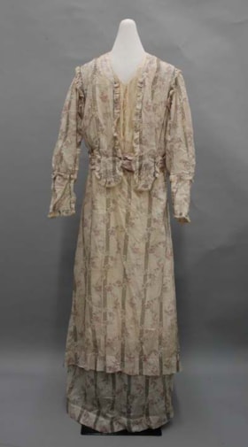
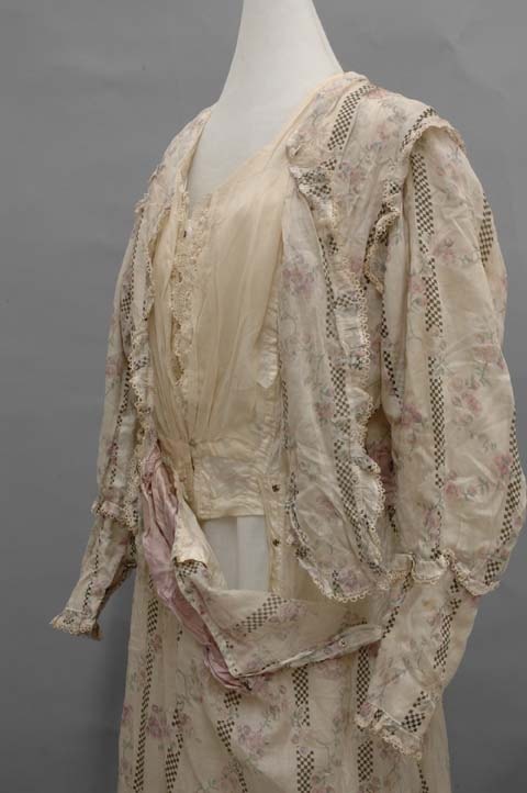
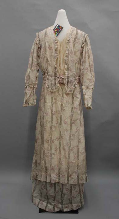
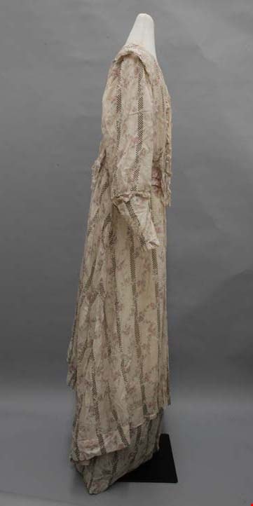
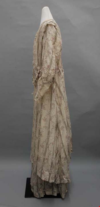
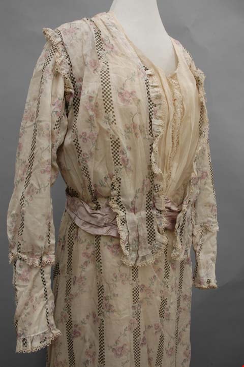
dress
https://search.heritageburnaby.ca/link/museumartifact46565
- Repository
- Burnaby Village Museum
- Accession Code
- BV004.21.8
- Description
- Dress, c.1910-1913. Cotton lawn print in floral and checkered, with chiffon yoke, lace, and mauve satin silk waistband. Long tiered skirt, long sleeves, round neckline. The cotton lawn fabric has a white background with vertical stripes of black and white checkers; purple flowers with green stems intertwine around the vertical checkers. The neckline rounds into a slight V shape with a yoke of ivory chiffon on top of lace, which extends to the waistband. On the front and back right and left side of the bodice, there is a tab extending over the waistband from the bodice fabric, edged in lace. The bottom of the bodice is gathered to add some volume. The bodice is also open around the shoulders, edged with lace. There is a section of the main fabric underneath that connects to the lining. The sleeves are full length, with some volume. The cuff begins halfway down the forearm with a gathered lace ruffle. The cuff section is narrower, and ends with three snaps at the wrist and another lace ruffle. At the waist, there is a gathered mauve satin silk waistband, tacked on to the dress. The skirt is attached underneath in two tiers. The overskirt, attached to the bodice, has two somewhat flared gores and one godet on the right side seam from just above the knee to the calf. It also ends at the calf, and just above the hem there is a tiny band of drawn thread work embroidery. The bottom tier is attached to the skirt lining under the top hem; it is made up of four gores, all gathered. The lining to the dress is done in ivory china silk, and it extends into the sleeves. In the bodice lining, there are four bones to hold its shape: on in the centre front and back, and one on each side. There are six panels in the back and four in the front, all finished with flat felled seams. The centre front closes with hook and eyes, and the waistband is secured on top with snaps and a hook and eye; the left bodice tab is secured to the waistband with two snaps. The skirt lining is also china silk, closing down the left side front with snaps. The skirt also has a left side opening that closes with snaps. In each underarm there is a dress shield to protect the dress from perspiration. They each read: "Style 100 Trade Mark OMO. E. Y. 2. Odorless. No Rubber. Soak in cold soap suds, using good soap, scrub with a stiff brush, and rinse in clear cold water, shape carefully while wet, and dry thoroughly. Do not iron."
- Object History
- Object was inherited by the donor ca. 1974. She was given it by her mother, who had inherited it from her own mother, Elizabeth (Babb) Heaney.
- Subjects
- Clothing
- Clothing - Costumes
- Historic Neighbourhood
- Central Park (Historic Neighbourhood)
- Planning Study Area
- Maywood Area
Images


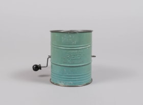
flour sifter
https://search.heritageburnaby.ca/link/museumartifact84014
- Repository
- Burnaby Village Museum
- Accession Code
- BV014.8.3
- Description
- Flour sifter made of sheet metal. The outside has been painted a light green. There is a wire handle to sift the flour throught wire mesh on the inside bottom. "BROMERLL'S BEE PAT. NO. 1,759,995" is embossed on the outside .
- Object History
- Object was used by the donor's mother, Jean Alexandra (Butchart) Bradley.
- Measurements
- Measuements: 11 cm diameter X 14.7 cm high at the front edge
- Geographic Access
- Wilson Avenue
- Street Address
- 3020 Wilson Avenue
- Historic Neighbourhood
- Central Park (Historic Neighbourhood)
- Planning Study Area
- Maywood Area
Images


Kingsway West School site
https://search.heritageburnaby.ca/link/museumdescription11122
- Repository
- Burnaby Village Museum
- Date
- March 16, 1915
- Collection/Fonds
- Ronald G. Scobbie collection
- Description Level
- Item
- Physical Description
- 1 survey plan : blueprint on paper with pencil notations ; 56 x 54 cm
- Scope and Content
- Survey plan of "Kingsway West School Site" "Burnaby Municipality" "being Lot 1, D.L.32, Lot 1 of Lot 21, Portion of Lot 21 and Portion of Lot 20, of subdivision of D.L.152, 153 & Portion of Lot 151, Group 1, New Westminster District". Notations in pencil extend along the south boundary line of Dist…
- Repository
- Burnaby Village Museum
- Collection/Fonds
- Ronald G. Scobbie collection
- Description Level
- Item
- Physical Description
- 1 survey plan : blueprint on paper with pencil notations ; 56 x 54 cm
- Material Details
- Scale: 40 feet = 1 inch
- Scope and Content
- Survey plan of "Kingsway West School Site" "Burnaby Municipality" "being Lot 1, D.L.32, Lot 1 of Lot 21, Portion of Lot 21 and Portion of Lot 20, of subdivision of D.L.152, 153 & Portion of Lot 151, Group 1, New Westminster District". Notations in pencil extend along the south boundary line of District Lot 32.
- Creator
- McGugan, Donald Johnston
- Subjects
- Buildings - Schools
- Names
- Kingsway West School
- Responsibility
- Burnett and McGugan B.C. Land Surveyors, New Westminster
- Geographic Access
- Kingsway
- Sussex Avenue
- Accession Code
- BV003.83.2
- Access Restriction
- No restrictions
- Reproduction Restriction
- No known restrictions
- Date
- March 16, 1915
- Media Type
- Cartographic Material
- Historic Neighbourhood
- Central Park (Historic Neighbourhood)
- Planning Study Area
- Maywood Area
- Scan Resolution
- 440
- Scan Date
- 22-Dec-2020
- Scale
- 100
- Notes
- Transcribed title
- Oath in bottom left corner reads: "I, D.J. McGugan...did personally superintend the survey ..." "...completed on the 16th day of March 1915", signed "D.J. McGugan" and is notarized on March 19th, 1915 by "S.F. Frank" with a seal
- handwritten on back, "1753";
- See also BV003.83.9 - duplicate blueprint plan without annotations
- See also BV003.83.3 for original plan on waxed linen
Zoomable Images

Kingsway West School site
https://search.heritageburnaby.ca/link/museumdescription11123
- Repository
- Burnaby Village Museum
- Date
- March 16, 1915
- Collection/Fonds
- Ronald G. Scobbie collection
- Description Level
- Item
- Physical Description
- 1 survey plan : blackline print on waxed linen ; 59 x 59 cm
- Scope and Content
- Survey plan titled “Kingsway West School Site" "Burnaby Municipality" / being Lot 1, D.L.32, Lot 1 of Lot 21, Portion of / Lot 21 and Portion of Lot 20, of subdivision / of D.L.152, 153 & Portion of Lot 151, Group 1 / New Westminster District".
- Repository
- Burnaby Village Museum
- Collection/Fonds
- Ronald G. Scobbie collection
- Description Level
- Item
- Physical Description
- 1 survey plan : blackline print on waxed linen ; 59 x 59 cm
- Material Details
- Scale [1:480]
- Scope and Content
- Survey plan titled “Kingsway West School Site" "Burnaby Municipality" / being Lot 1, D.L.32, Lot 1 of Lot 21, Portion of / Lot 21 and Portion of Lot 20, of subdivision / of D.L.152, 153 & Portion of Lot 151, Group 1 / New Westminster District".
- Subjects
- Buildings - Schools
- Names
- Kingsway West School
- Geographic Access
- Kingsway
- Sussex Avenue
- Accession Code
- BV003.83.3
- Access Restriction
- No restrictions
- Reproduction Restriction
- No known restrictions
- Date
- March 16, 1915
- Media Type
- Cartographic Material
- Historic Neighbourhood
- Central Park (Historic Neighbourhood)
- Planning Study Area
- Maywood Area
- Notes
- Transcribed title
- Scale on plan reads" 40 feet = 1 inch"
- Oath on plan reads: "I, D.J. McGugan...did personally superintend the survey ..." "...completed on the 16th day of March 1915", signed "D.J. McGugan", and notarized by "S.F. Mark
- See also BV0003.83.2 for digitized blueprint
Kingsway West School site
https://search.heritageburnaby.ca/link/museumdescription11130
- Repository
- Burnaby Village Museum
- Date
- March 16, 1915
- Collection/Fonds
- Ronald G. Scobbie collection
- Description Level
- Item
- Physical Description
- 1 survey plan : blueprint on paper ; 56 x 54 cm
- Scope and Content
- Survey plan of "Kingsway West School Site" "Burnaby Municipality" "being Lot 1, D.L.32, Lot 1 of Lot 21, Portion of Lot 21 and Portion of Lot 20, of subdivision of D.L.152, 153 & Portion of Lot 151, Group 1, New Westminster District".
- Repository
- Burnaby Village Museum
- Collection/Fonds
- Ronald G. Scobbie collection
- Description Level
- Item
- Physical Description
- 1 survey plan : blueprint on paper ; 56 x 54 cm
- Material Details
- Scale: [1:480]
- Scope and Content
- Survey plan of "Kingsway West School Site" "Burnaby Municipality" "being Lot 1, D.L.32, Lot 1 of Lot 21, Portion of Lot 21 and Portion of Lot 20, of subdivision of D.L.152, 153 & Portion of Lot 151, Group 1, New Westminster District".
- Creator
- McGugan, Donald Johnston
- Subjects
- Buildings - Schools
- Names
- Kingsway West School
- Geographic Access
- Kingsway
- Sussex Avenue
- Accession Code
- BV003.83.9
- Access Restriction
- No restrictions
- Reproduction Restriction
- No known restrictions
- Date
- March 16, 1915
- Media Type
- Cartographic Material
- Historic Neighbourhood
- Central Park (Historic Neighbourhood)
- Planning Study Area
- Maywood Area
- Notes
- Title based on contents of plan
- Scale on plan reads: "40 feet = 1 inch"
- Oath in bottom left corner reads: "I, D.J. McGugan...did personally superintend the survey ..." "...completed on the 16th day of March 1915", signed "D.J. McGugan", and notarized by "S.F. Mark
- handwritten on back, "1753
- See also BV003.83.2 - duplicate plan with annotations- digitized in 2020
- See also BV003.83.3 for original plan on waxed linen
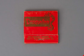
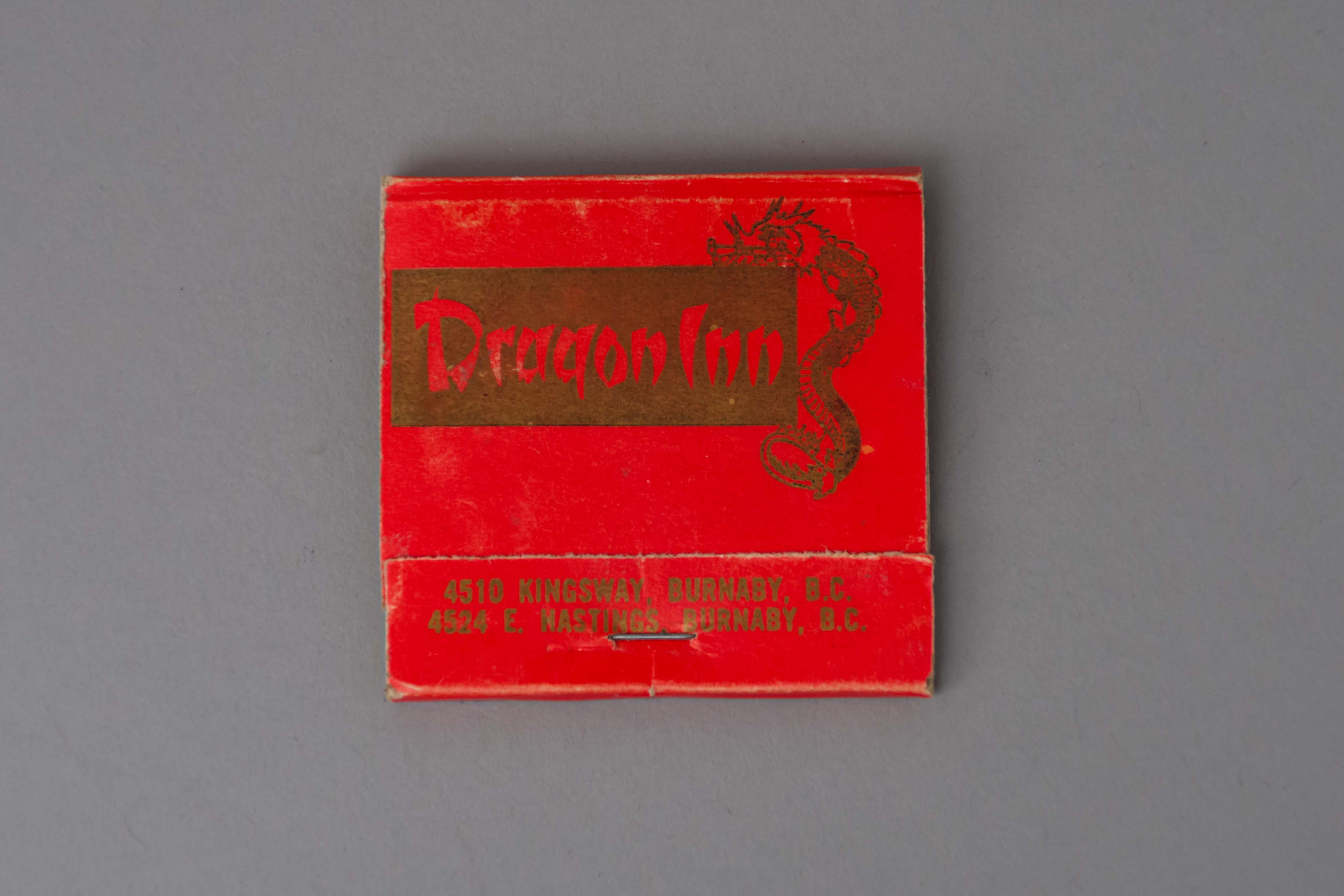
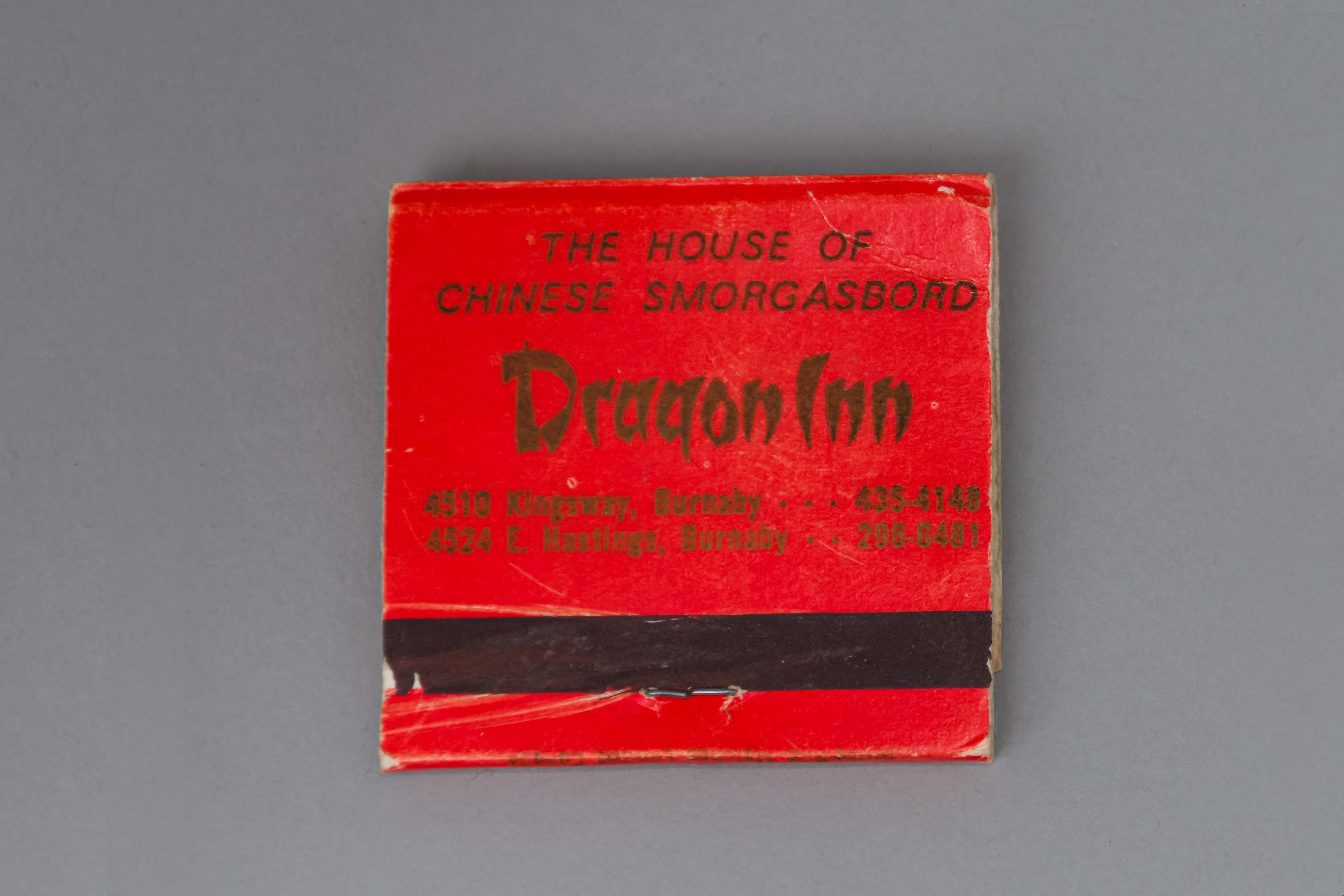
matchbook
https://search.heritageburnaby.ca/link/museumartifact89161
- Repository
- Burnaby Village Museum
- Accession Code
- BV017.37.8
- Description
- matchbook; red folded paper with gold ink text and illustration of a dragon; "Dragon Inn / 4510 KINGSWAY, BURNABY, B.C. / 4524 E. HASTINGS, BURNABY B.C." printed on face; "THE HOUSE OF / CHINESE SMORGASBORD / Dragon Inn / 4510 Kingsway, Burnaby . . . 435-4148 / 4524 E. Hastings . . . 298-6481". There are pink-tipped matches in the book.
- Object History
- Dragon Inn belonged to the Lee family. The Dragon Inn restaurant was located at at 4510 Kingsway, on the corner of Kingsway and Willingdon Avenue (opened in the 1970s) and later at Hastings Street near Willingdon (opened in the 1990s). The Dragon Inn was known for its exterior neon sign which was removed in 1997.
- Category
- 02. Furnishings
- Classification
- Temperature Control Equipment - - Firemaking Equipment
- Object Term
- Matchbook
- Names
- Dragon Inn
- Geographic Access
- Kingsway
- Street Address
- 4510 Kingsway
- Historic Neighbourhood
- Central Park (Historic Neighbourhood)
- Planning Study Area
- Maywood Area
Images
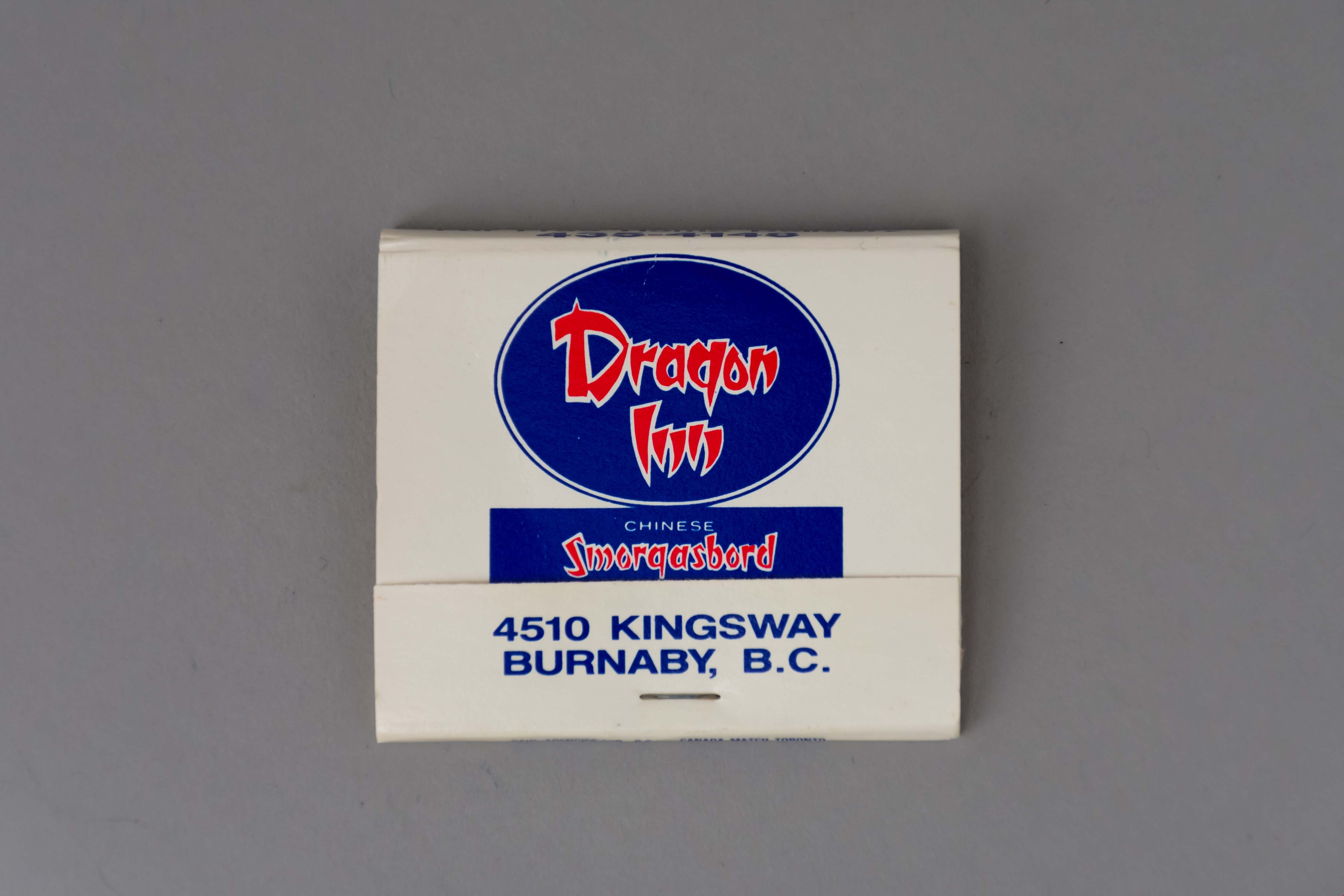
matchbook
https://search.heritageburnaby.ca/link/museumartifact89162
- Repository
- Burnaby Village Museum
- Accession Code
- BV017.37.9
- Description
- matchbook; white folded paper with blue and red ink text and illustration of a dragon; "Dragon / Inn / CHINESE / Smorgasbord / EVERY DAY / 4510 KINGSWAY / BURNABY, B.C." printed on face; business hours printed on back. There are blue-tipped matches in the book; manufactured by "DAHL AGENCIES LTD, B.C. * CANADA MATCH TORONTO".
- Object History
- Dragon Inn belonged to the Lee family. The Dragon Inn restaurant was located at at 4510 Kingsway, on the corner of Kingsway and Willingdon Avenue (opened in the 1970s) and later at Hastings Street near Willingdon (opened in the 1990s). The Dragon Inn was known for its exterior neon sign which was removed in 1997.
- Category
- 02. Furnishings
- Classification
- Temperature Control Equipment - - Firemaking Equipment
- Object Term
- Matchbook
- Names
- Dragon Inn
- Geographic Access
- Kingsway
- Street Address
- 4510 Kingsway
- Historic Neighbourhood
- Central Park (Historic Neighbourhood)
- Planning Study Area
- Maywood Area
Images
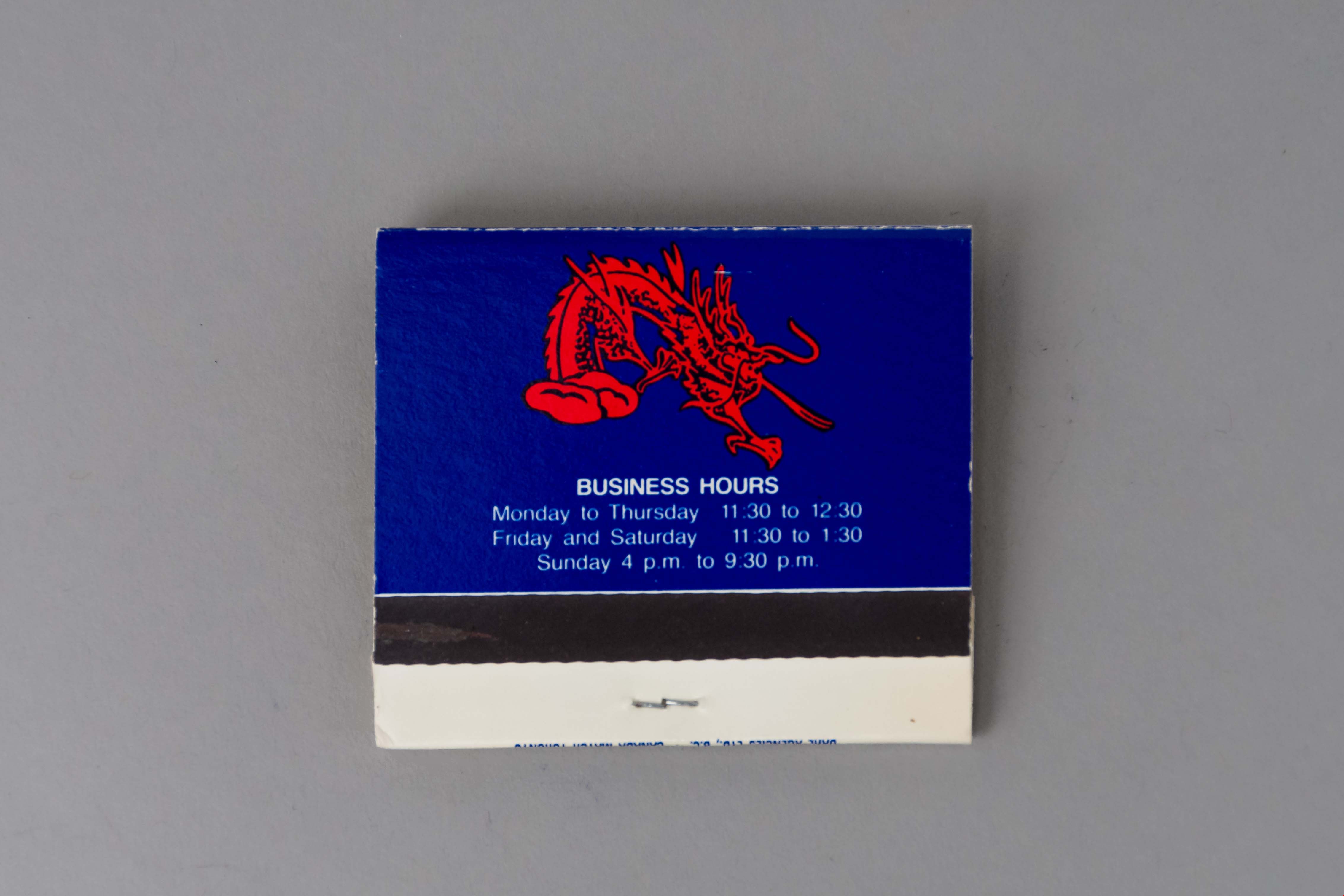

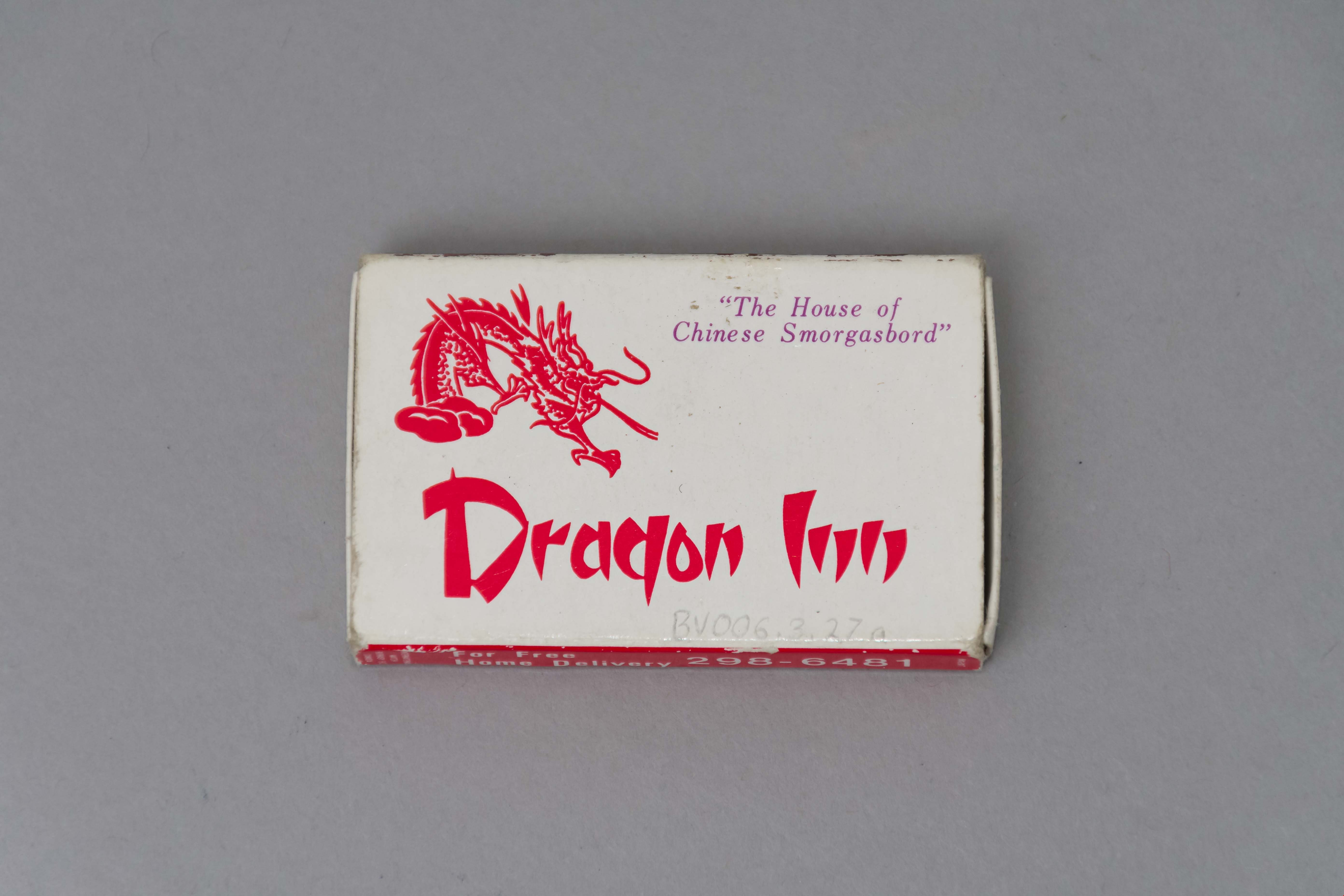
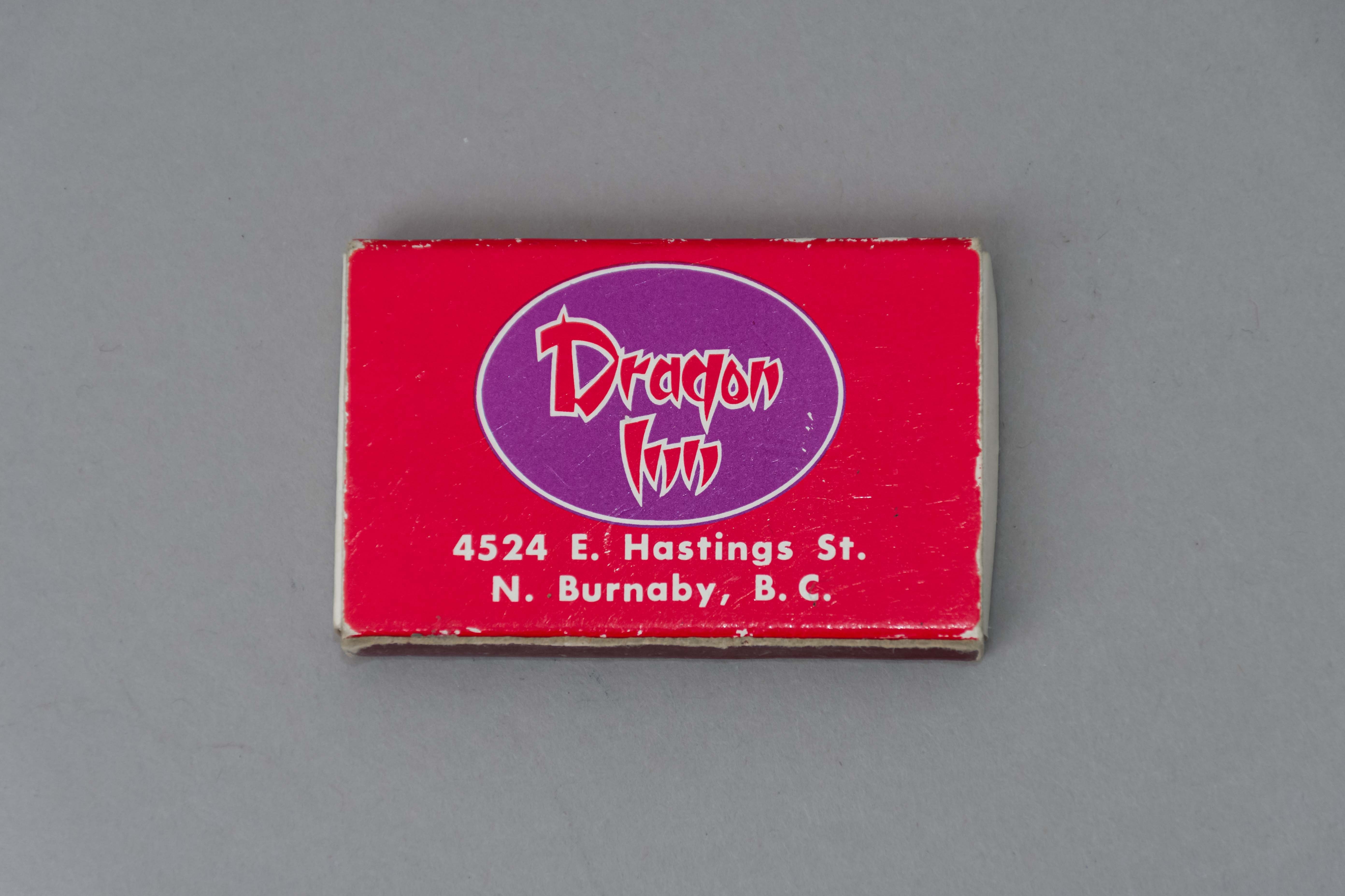
matchbox
https://search.heritageburnaby.ca/link/museumartifact50021
- Repository
- Burnaby Village Museum
- Accession Code
- BV006.3.27
- Description
- Red and white paper match box The tray slides out of the outer covering. Outer covering features a red dragon "The House of / Chinese Smorgasbord / Dragon Inn." One side of the outer covering features a strike area the other " For Free / Home Delivery / 298 - 6481..." The other side of the outer covering " ...4524 E. hastings St. / N. Burnaby, B.C.".
- Object History
- Dragon Inn belonged to the Lee family. The Dragon Inn restaurant was located at at 4510 Kingsway, on the corner of Kingsway and Willingdon Avenue (opened in the 1970s) and later at Hastings Street near Willingdon (opened in the 1990s). The Dragon Inn was known for its exterior neon sign which was removed in 1997.
- Category
- 02. Furnishings
- Classification
- Temperature Control Equipment - - Firemaking Equipment
- Object Term
- Matchbox
- Names
- Dragon Inn
- Historic Neighbourhood
- Central Park (Historic Neighbourhood)
- Planning Study Area
- Maywood Area
Images

Municipality of Burnaby - Volume XV and Volume XVIII
https://search.heritageburnaby.ca/link/museumdescription8680
- Repository
- Burnaby Village Museum
- Date
- May 1927
- Collection/Fonds
- Burnaby Village Museum Map collection
- Description Level
- File
- Physical Description
- 4 plans on 4 sheets : col. lithographic prints ; 63.5 x 53.5 cm folded to 53 x 31.5 cm
- Scope and Content
- File consists of four pages of plans removed from a bound book containing a series of fire insurance plans of the Municipality of Burnaby. The first two pages are numbered "A" and "B" and are key plans from "GREATER VANCOUVER B.C. / VOLUME XV / Surveyed _ May 1927 / MUNICIPALITY OF / BURNABY", "PLA…
- Repository
- Burnaby Village Museum
- Collection/Fonds
- Burnaby Village Museum Map collection
- Description Level
- File
- Physical Description
- 4 plans on 4 sheets : col. lithographic prints ; 63.5 x 53.5 cm folded to 53 x 31.5 cm
- Material Details
- Scales [1:1200] and [1:6000]
- Scope and Content
- File consists of four pages of plans removed from a bound book containing a series of fire insurance plans of the Municipality of Burnaby. The first two pages are numbered "A" and "B" and are key plans from "GREATER VANCOUVER B.C. / VOLUME XV / Surveyed _ May 1927 / MUNICIPALITY OF / BURNABY", "PLAN DEPT. FIRE BRANCH _ B.C. INSURANCE UNDERWRITERS ASSN.". Key Plan "B" covers plans: 1505; 1506; 1512 to 1516; 1540 to 1544; 1550 to 1557 and District Lots: 129 to 132; 135 to 138; 205 to 208 and 215 to 218. Key Plan "A" covers plans: 1501 to 1504; 1507 to 1511; 1517 to 1525; 1531 to 1539; 1545 to 1550 and District Lots: 116 to 127 and 186 to 189. Plan "1806" is part of "GREATER VANCOUVER B.C. / VOLUME XVIII / Municipality of Burnaby / May, 1927" and covers District Lot 153. Plan "1807" is from "GREATER VANCOUVER B.C. / VOLUME XVIII / Municipality of Burnaby / May, 1927" and covers District Lots: 99,149 and 152.
- Responsibility
- British Columbia Underwriters' Association
- Accession Code
- HV972.111.2
- Access Restriction
- No restrictions
- Reproduction Restriction
- May be restricted by third party rights
- Date
- May 1927
- Media Type
- Cartographic Material
- Historic Neighbourhood
- Vancouver Heights (Historic Neighbourhood)
- Lochdale (Historic Neighbourhood)
- Capitol Hill (Historic Neighbourhood)
- Central Park (Historic Neighbourhood)
- Alta Vista (Historic Neighbourhood)
- Planning Study Area
- Burnaby Heights Area
- Sperling-Broadway Area
- Lochdale Area
- Parkcrest-Aubrey Area
- Westridge Area
- Willingdon Heights Area
- Capitol Hill Area
- Maywood Area
- Marlborough Area
- Scan Resolution
- 400
- Scan Date
- 2021-11-18
- Notes
- Title based on content of plans
- Scales are measured 1 inch = 100 feet and 1 inch = 500 feet
- See also BV987.1.70d for revised versions of plans
Zoomable Images


Municipality of Burnaby - Volume XV and Volume XVIII
https://search.heritageburnaby.ca/link/museumdescription8681
- Repository
- Burnaby Village Museum
- Date
- May 1927
- Collection/Fonds
- Burnaby Village Museum Map collection
- Description Level
- File
- Physical Description
- 4 plans on 4 sheets : col. lithographic prints, ms. annotations in blue ink ; 63.5 x 53.5 cm folded to 53 x 31.5 cm
- Scope and Content
- File consists of four pages of plans removed from a bound book containing a series of fire insurance plans of the Municipality of Burnaby. Plan "1507" and plan "1517" are from "GREATER VANCOUVER B.C. / VOLUME XV / Municipality of Burnaby / May, 1927". Plan "1507" covers District Lot 186 and plan "1…
- Repository
- Burnaby Village Museum
- Collection/Fonds
- Burnaby Village Museum Map collection
- Description Level
- File
- Physical Description
- 4 plans on 4 sheets : col. lithographic prints, ms. annotations in blue ink ; 63.5 x 53.5 cm folded to 53 x 31.5 cm
- Material Details
- Scale [1:600] and [1:1200]
- Scope and Content
- File consists of four pages of plans removed from a bound book containing a series of fire insurance plans of the Municipality of Burnaby. Plan "1507" and plan "1517" are from "GREATER VANCOUVER B.C. / VOLUME XV / Municipality of Burnaby / May, 1927". Plan "1507" covers District Lot 186 and plan "1517" covers District Lot 116. Plan "1804" and plan "1805" are from "GREATER VANCOUVER B.C. / VOLUME XVIII / Municipality of Burnaby / May, 1927". Plans "1804" and "1805" cover District Lot 153.
- Responsibility
- British Columbia Underwriters' Association
- Accession Code
- HV972.111.3
- Access Restriction
- No restrictions
- Reproduction Restriction
- May be restricted by third party rights
- Date
- May 1927
- Media Type
- Cartographic Material
- Historic Neighbourhood
- Central Park (Historic Neighbourhood)
- Vancouver Heights (Historic Neighbourhood)
- Planning Study Area
- Maywood Area
- Willingdon Heights Area
- Scan Resolution
- 400
- Scan Date
- 2021-11-18
- Notes
- Title based on content of plans
- See also BV987.1.70d for revised versions of plans
- Scale is measured 1 inch = 100 feet
Images


Municipality of Burnaby - Volume XV, Volume XVI, Volume XVII, Volume XVIII
https://search.heritageburnaby.ca/link/museumdescription8685
- Repository
- Burnaby Village Museum
- Date
- May 1927
- Collection/Fonds
- Burnaby Village Museum Map collection
- Description Level
- File
- Physical Description
- 4 plans on 4 sheets : col. lithographic prints ; 63.5 x 53.5 cm folded to 53 x 31.5 cm
- Scope and Content
- File consists of four pages of plans removed from a bound book containing a series of fire insurance plans of the Municipality of Burnaby. Plan "1531" is part of "GREATER VANCOUVER B.C. / VOLUME XV / Municipality of Burnaby / May 1927" and covers District Lots: 116 and 117. Key Plan "C" is part of …
- Repository
- Burnaby Village Museum
- Collection/Fonds
- Burnaby Village Museum Map collection
- Description Level
- File
- Physical Description
- 4 plans on 4 sheets : col. lithographic prints ; 63.5 x 53.5 cm folded to 53 x 31.5 cm
- Material Details
- Scale [1:600] and [1:1200]
- Scope and Content
- File consists of four pages of plans removed from a bound book containing a series of fire insurance plans of the Municipality of Burnaby. Plan "1531" is part of "GREATER VANCOUVER B.C. / VOLUME XV / Municipality of Burnaby / May 1927" and covers District Lots: 116 and 117. Key Plan "C" is part of "GREATER VANCOUVER B.C. / VOLUME XVI / Municipality of Burnaby / May 1927" and covers plans 1623 to 1651 and District Lots: 1 and 2; 4; 6; 8; 10 to 14; 25; 27; 40; 56 to 58; 88 and 89. Plan "1738" is part of "GREATER VANCOUVER B.C. / VOLUME XVII / Municipality of Burnaby / May 1927" and covers District Lots: 34 and 35. Key plan "G" is part of "GREATER VANCOUVER B.C. / VOLUME XVIII / Municipality of Burnaby / May 1927" and covers plans: 1801 to 1813; 1823; 1824; 1833 to 1838; 1841 to 1853 and District Lots: 32; 93; 94; 97 to 99; 149; 150; 152; 155 to 159; 161 to 164.
- Responsibility
- British Columbia Underwriters' Association
- Accession Code
- HV972.111.7
- Access Restriction
- No restrictions
- Reproduction Restriction
- May be restricted by third party rights
- Date
- May 1927
- Media Type
- Cartographic Material
- Historic Neighbourhood
- Central Park (Historic Neighbourhood)
- Fraser Arm (Historic Neighbourhood)
- Alta Vista (Historic Neighbourhood)
- Broadview (Historic Neighbourhood)
- Vancouver Heights (Historic Neighbourhood)
- Burquitlam (Historic Neighbourhood)
- East Burnaby (Historic Neighbourhood)
- Edmonds (Historic Neighbourhood)
- Lozells (Historic Neighbourhood)
- Planning Study Area
- Clinton-Glenwood Area
- Marlborough Area
- Maywood Area
- Windsor Area
- Big Bend Area
- Garden Village Area
- Willingdon Heights Area
- West Central Valley Area
- Cariboo-Armstrong Area
- Lyndhurst Area
- Cameron Area
- Lake City Area
- Edmonds Area
- Second Street Area
- Sperling-Broadway Area
- Lakeview-Mayfield Area
- Scan Resolution
- 400
- Scan Date
- 2021-11-18
- Notes
- Title based on content of plans
- See also BV987.1.70d for revised versions of plans
- Scale is measured 1 inch = 500 feet
Zoomable Images

Municipality of Burnaby - Volume XV, Volume XVI, Volume XVII, Volume XVIII, May 1927
Zoom into Image
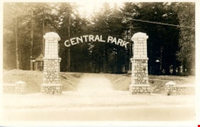
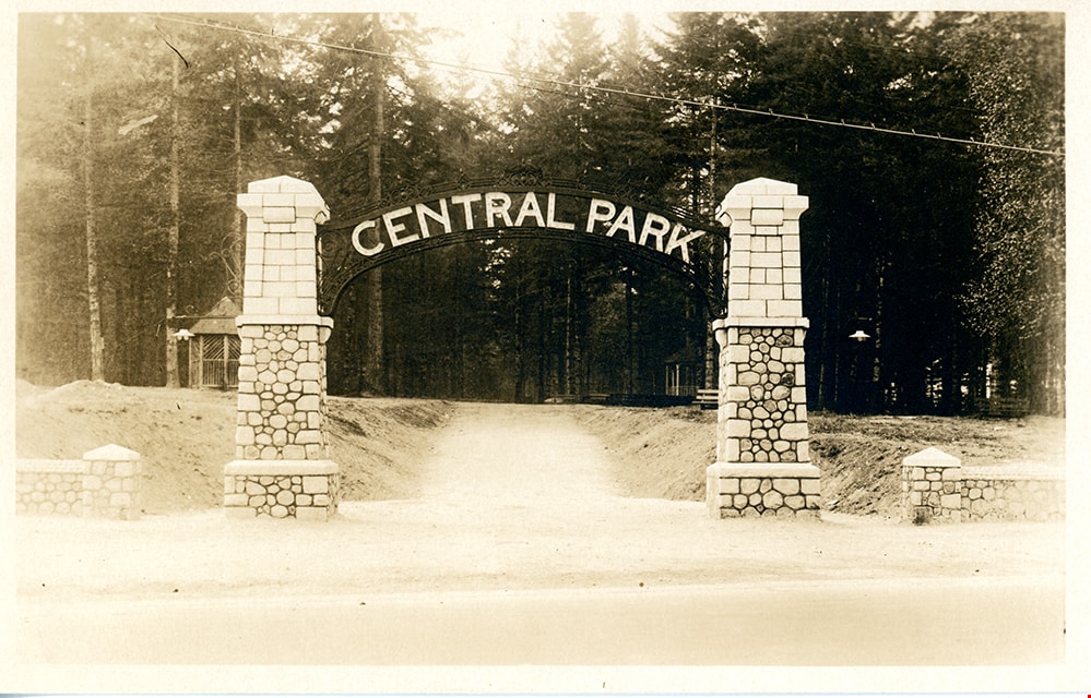
postcard
https://search.heritageburnaby.ca/link/museumartifact84668
- Repository
- Burnaby Village Museum
- Accession Code
- BV007.43.1
- Description
- postcard; black and white photograph of entrance arches to Central Park in Burnaby - [192-]. The postcard was published by the Gowen Sutton Company Limited of Vancouver, BC. Stamp in black ink on verso of postcard reads "PUBLISHED BY THE GOWEN SUTTON CO. LTD. VANCOUVER, B.C. / POSTCARD / CORRESPONDENCE_ADDRESS"
- Object History
- Souvenir postcard of Burnaby Central Park entrance arch.
- Classification
- Written Communication T&E - - Writing Media
- Object Term
- Postcard
- Colour
- Brown
- White
- Measurements
- w: 14 cm h: 9 cm
- Country Made
- Canada
- Province Made
- British Columbia
- Site/City Made
- Vancouver
- Subjects
- Structures - Arches
- Documentary Artifacts
- Documentary Artifacts - Postcards
- Geographic Features - Parks
- Geographic Access
- Central Park
- Imperial Street
- Street Address
- 3883 Imperial Street
- Historic Neighbourhood
- Central Park (Historic Neighbourhood)
- Planning Study Area
- Maywood Area
Images

product package; cigar box
https://search.heritageburnaby.ca/link/museumartifact20892
- Repository
- Burnaby Village Museum
- Accession Code
- HV976.14.43
- Description
- Box, cigar
- Object History
- This cigar box came from a family who settled in Burnaby in the 1920s,on 3512 Chaffey Avenue in Burnaby. In the 1921 census, William is listed as a poultry rancher. Their children attended Inman Avenue School in Burnaby.
- Category
- 04.Tools & Equipment for Materials
- Classification
- Household Accessories - - Containers for Smoking & Tobacco
- Object Term
- Box, Cigar
- Subjects
- Personal Gear
- Historic Neighbourhood
- Central Park (Historic Neighbourhood)
- Planning Study Area
- Maywood Area
Images