Narrow Results By
Subject
- Accidents 1
- Animals - Cats 2
- Animals - Dogs 3
- Buildings - Commercial 1
- Buildings - Commercial - Banks 7
- Buildings - Commercial - Malls 1
- Buildings - Commercial - Stores 6
- Buildings - Commercial - Train Stations 1
- Buildings - Industrial 2
- Buildings - Residential 1
- Buildings - Residential - Houses 10
- Ceremonies 1
![May Day procession, [1935 or 1936] (date of original), copied 1992 thumbnail](/media/hpo/_Data/_Archives_Images/_Unrestricted/315/315-345.jpg?width=280)
May Day procession
https://search.heritageburnaby.ca/link/archivedescription36887
- Repository
- City of Burnaby Archives
- Date
- [1935 or 1936] (date of original), copied 1992
- Collection/Fonds
- Burnaby Historical Society fonds
- Description Level
- Item
- Physical Description
- 1 photograph : b&w ; 8.7 x 12.6 cm print
- Scope and Content
- Photograph of the Burnaby May Day procession at Central Park.
- Repository
- City of Burnaby Archives
- Date
- [1935 or 1936] (date of original), copied 1992
- Collection/Fonds
- Burnaby Historical Society fonds
- Subseries
- Burnaby Centennial Anthology subseries
- Physical Description
- 1 photograph : b&w ; 8.7 x 12.6 cm print
- Description Level
- Item
- Record No.
- 315-345
- Access Restriction
- No restrictions
- Reproduction Restriction
- No known restrictions
- Accession Number
- BHS1994-04
- Scope and Content
- Photograph of the Burnaby May Day procession at Central Park.
- Subjects
- Symbols - Flags
- Events - May Day
- Media Type
- Photograph
- Notes
- Title based on contents of photograph
- Geographic Access
- Imperial Street
- Street Address
- 3883 Imperial Street
- Historic Neighbourhood
- Central Park (Historic Neighbourhood)
- Planning Study Area
- Maywood Area
Images
![May Day procession, [1935 or 1936] (date of original), copied 1992 thumbnail](/media/hpo/_Data/_Archives_Images/_Unrestricted/315/315-345.jpg)
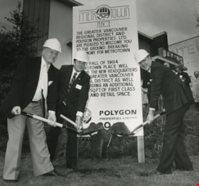
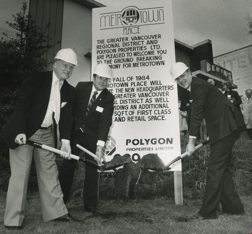
Mayor Bill Lewarne, Jim Tonn and Michael Audain
https://search.heritageburnaby.ca/link/archivedescription45386
- Repository
- City of Burnaby Archives
- Date
- 1983
- Collection/Fonds
- Columbian Newspaper collection
- Description Level
- Item
- Physical Description
- 1 photograph : b&w ; 19 x 20.5 cm
- Scope and Content
- Photograph of Burnaby Mayor Bill Lewarne, Jim Tonn from the Greater Vancouver Regional District (now Metro Vancouver), and the President of Polygon Michael Audain each with a shovel full of dirt at the ground breaking ceremony for Metrotown Place, the new headquaters for the Greater Vancouver Regio…
- Repository
- City of Burnaby Archives
- Date
- 1983
- Collection/Fonds
- Columbian Newspaper collection
- Physical Description
- 1 photograph : b&w ; 19 x 20.5 cm
- Description Level
- Item
- Record No.
- 480-281
- Access Restriction
- No restrictions
- Reproduction Restriction
- No restrictions
- Accession Number
- 2003-02
- Scope and Content
- Photograph of Burnaby Mayor Bill Lewarne, Jim Tonn from the Greater Vancouver Regional District (now Metro Vancouver), and the President of Polygon Michael Audain each with a shovel full of dirt at the ground breaking ceremony for Metrotown Place, the new headquaters for the Greater Vancouver Regional District (now Metro Vancouver).
- Media Type
- Photograph
- Photographer
- Battistoni, Peter
- Notes
- Title based on contents of photograph
- Geographic Access
- Kingsway
- Street Address
- 4330 Kingsway
- Historic Neighbourhood
- Central Park (Historic Neighbourhood)
- Planning Study Area
- Maywood Area
Images
![Maypole Dance, [193-] thumbnail](/media/hpo/_Data/_BVM_Images/1976/1976_0143_0008_001.jpg?width=280)
Maypole Dance
https://search.heritageburnaby.ca/link/museumdescription828
- Repository
- Burnaby Village Museum
- Date
- [193-]
- Collection/Fonds
- Burnaby Village Museum Photograph collection
- Description Level
- Item
- Physical Description
- 1 photograph : b&w ; 12.3 x 17.4 cm
- Scope and Content
- Photograph of a Maypole Dance at a May Day celebration (location and year unidentified). In the photograph, groups of children can be seen around two maypoles. One is a group of all girls, the other group composed of boys and girls, alternating. The girls are wearing blouses and frill skirts wit…
- Repository
- Burnaby Village Museum
- Collection/Fonds
- Burnaby Village Museum Photograph collection
- Description Level
- Item
- Physical Description
- 1 photograph : b&w ; 12.3 x 17.4 cm
- Scope and Content
- Photograph of a Maypole Dance at a May Day celebration (location and year unidentified). In the photograph, groups of children can be seen around two maypoles. One is a group of all girls, the other group composed of boys and girls, alternating. The girls are wearing blouses and frill skirts with flowers in their hair. The boys are in shirts and shorts. There is a large crowd of people gathered to watch the dance. Automobiles can be seen parked behind the crowd. Inscribed in the negative and printed on the photograph, bottom front: "A."
- Geographic Access
- Central Park
- Accession Code
- HV976.143.8
- Access Restriction
- No restrictions
- Reproduction Restriction
- No known restrictions
- Date
- [193-]
- Media Type
- Photograph
- Historic Neighbourhood
- Central Park (Historic Neighbourhood)
- Planning Study Area
- Maywood Area
- Scan Resolution
- 600
- Scan Date
- 2023-06-27
- Photographer
- Stride, Charles Edgar
- Notes
- Title based on contents of photograph
- The photographs in the accession HV976.143 are thought to be by the Stride studio, as the donor indicated in her letter that the Stride family were personal friends of her great-aunt and her husband, who resided in Edmonds. She wrote that she received a picture of the New Westminster or Burnaby May Day celebrations each year.
Images
![Maypole Dance, [193-] thumbnail](/media/hpo/_Data/_BVM_Images/1976/1976_0143_0008_001.jpg)
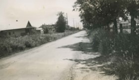
McKay Avenue
https://search.heritageburnaby.ca/link/archivedescription36431
- Repository
- City of Burnaby Archives
- Date
- 1932
- Collection/Fonds
- Burnaby Historical Society fonds
- Description Level
- Item
- Physical Description
- 1 photograph : sepia ; 6 x 10.5 cm
- Scope and Content
- Photograph of McKay Avenue with long grass and flowering trees bordering the roadway.
- Repository
- City of Burnaby Archives
- Date
- 1932
- Collection/Fonds
- Burnaby Historical Society fonds
- Subseries
- Martin family subseries
- Physical Description
- 1 photograph : sepia ; 6 x 10.5 cm
- Description Level
- Item
- Record No.
- 270-003
- Access Restriction
- No restrictions
- Reproduction Restriction
- No known restrictions
- Accession Number
- BHS1991-39
- Scope and Content
- Photograph of McKay Avenue with long grass and flowering trees bordering the roadway.
- Subjects
- Geographic Features - Roads
- Media Type
- Photograph
- Notes
- Title based on contents of photograph
- Geographic Access
- McKay Avenue
- Historic Neighbourhood
- Central Park (Historic Neighbourhood)
- Planning Study Area
- Maywood Area
Images

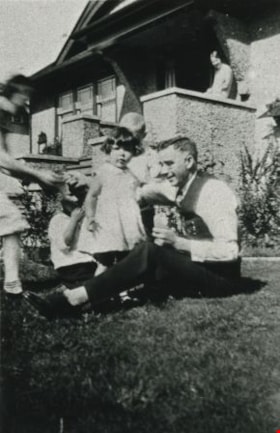
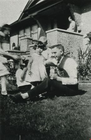
McKee family
https://search.heritageburnaby.ca/link/archivedescription35652
- Repository
- City of Burnaby Archives
- Date
- 1931 (date of original), copied 1986
- Collection/Fonds
- Burnaby Historical Society fonds
- Description Level
- Item
- Physical Description
- 1 photograph : b&w ; 12.7 x 17.8 cm print
- Scope and Content
- Photograph of Dr. Boyd McKee (seated) with daughter, Doree McKee (standing next to Dr. McKee). Bessie Farthing, boarder and close family friend, is on the steps in the background. Doree McKee Piercy was also to become a doctor. The photograph was taken at the family home, 3375 Patterson Avenue (lat…
- Repository
- City of Burnaby Archives
- Date
- 1931 (date of original), copied 1986
- Collection/Fonds
- Burnaby Historical Society fonds
- Subseries
- Pioneer Tales subseries
- Physical Description
- 1 photograph : b&w ; 12.7 x 17.8 cm print
- Description Level
- Item
- Record No.
- 204-510
- Access Restriction
- No restrictions
- Reproduction Restriction
- No known restrictions
- Accession Number
- BHS1988-03
- Scope and Content
- Photograph of Dr. Boyd McKee (seated) with daughter, Doree McKee (standing next to Dr. McKee). Bessie Farthing, boarder and close family friend, is on the steps in the background. Doree McKee Piercy was also to become a doctor. The photograph was taken at the family home, 3375 Patterson Avenue (later renumbered 5790 Patterson Avenue), where the McKees lived from 1926 to 1948.
- Media Type
- Photograph
- Notes
- Title based on contents of photograph
- Geographic Access
- Patterson Avenue
- Street Address
- 5790 Patterson Avenue
- Historic Neighbourhood
- Central Park (Historic Neighbourhood)
- Planning Study Area
- Maywood Area
Images

Metrotown Station Square
https://search.heritageburnaby.ca/link/archivedescription93745
- Repository
- City of Burnaby Archives
- Date
- November 1989
- Collection/Fonds
- Grover, Elliott & Co. Ltd. fonds
- Description Level
- File
- Physical Description
- 83 photographs : col. negatives ; 35 mm + 2 computer disks ; 14 x 14 cm
- Scope and Content
- Photographs of Metrotown Station Square during construction. Businesses visible in the photographs include: Eastons, Holiday Inn, Future Shop, Great Canadian Superstore, and Toy City Consumers.
- Repository
- City of Burnaby Archives
- Date
- November 1989
- Collection/Fonds
- Grover, Elliott & Co. Ltd. fonds
- Physical Description
- 83 photographs : col. negatives ; 35 mm + 2 computer disks ; 14 x 14 cm
- Description Level
- File
- Record No.
- 622-030
- Access Restriction
- No restrictions
- Reproduction Restriction
- No restrictions
- Accession Number
- 2017-39
- Scope and Content
- Photographs of Metrotown Station Square during construction. Businesses visible in the photographs include: Eastons, Holiday Inn, Future Shop, Great Canadian Superstore, and Toy City Consumers.
- Media Type
- Photograph
- Notes
- Transcribed title
- Title transcribed from print envelopes photographs were originally housed in
- File no. 89-512-B
- Computer disks are labelled "Station Square Metro Town Nov /89". Computer disk envelopes are labelled "Suite 660-1380 Burrard ST / Van, BC"
- Geographic Access
- McKay Avenue
- Street Address
- 6200 McKay Avenue
- Historic Neighbourhood
- Central Park (Historic Neighbourhood)
- Planning Study Area
- Maywood Area
Images

New Haven Borstal Home for Boys and Youthful Offenders
https://search.heritageburnaby.ca/link/archivedescription36288
- Repository
- City of Burnaby Archives
- Date
- May 1939
- Collection/Fonds
- Burnaby Historical Society fonds
- Description Level
- Item
- Physical Description
- 1 photograph : b&w ; 6.5 x 10 cm
- Scope and Content
- Photograph of the New Haven Borstal Home for Boys and Youthful Offenders on George A. Grant's lawn, watching for King George VI and Queen Elizabeth to travel along Kingsway as part of their visit to British Columbia. Everyone has flags in their hands, including the four men in suits that are accomp…
- Repository
- City of Burnaby Archives
- Date
- May 1939
- Collection/Fonds
- Burnaby Historical Society fonds
- Subseries
- George Grant subseries
- Physical Description
- 1 photograph : b&w ; 6.5 x 10 cm
- Description Level
- Item
- Record No.
- 243-008
- Access Restriction
- Restricted access
- Reproduction Restriction
- No known restrictions
- Accession Number
- BHS1990-06
- Scope and Content
- Photograph of the New Haven Borstal Home for Boys and Youthful Offenders on George A. Grant's lawn, watching for King George VI and Queen Elizabeth to travel along Kingsway as part of their visit to British Columbia. Everyone has flags in their hands, including the four men in suits that are accompanying the reform school students.
- Subjects
- Clothing - Uniforms
- Symbols - Flags
- Media Type
- Photograph
- Notes
- Title based on contents of photograph
- Stamp on verso of print reads: KODATONE
- Geographic Access
- Sussex Avenue
- Street Address
- 4700 Kingsway
- Historic Neighbourhood
- Central Park (Historic Neighbourhood)
- Planning Study Area
- Maywood Area
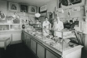
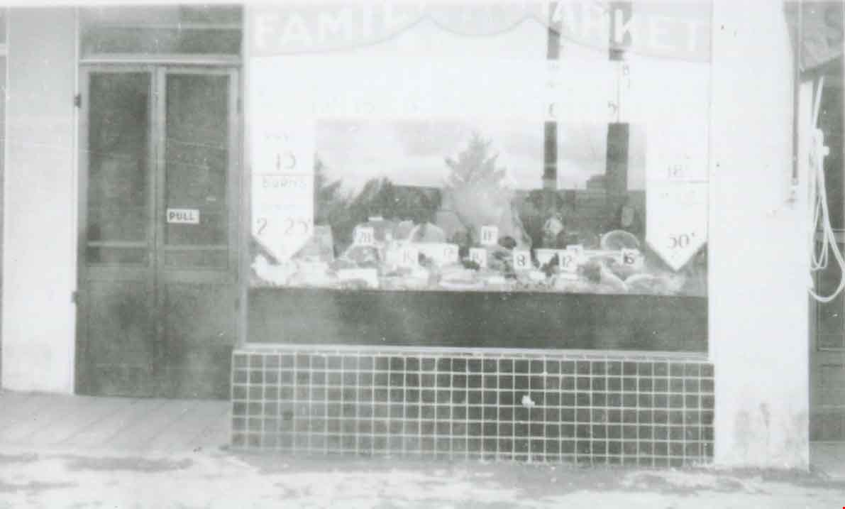
Nichol's Butcher Shop
https://search.heritageburnaby.ca/link/archivedescription36656
- Repository
- City of Burnaby Archives
- Date
- 1930 (date of original), copied 1992
- Collection/Fonds
- Burnaby Historical Society fonds
- Description Level
- Item
- Physical Description
- 1 photograph : b&w ; 8.5 x 12.5 cm print
- Scope and Content
- Photograph of the interior of Nichol's Butcher Shop at 4018 Kingsway (later renumbered 4500 Kingsway). Harry O'Brien (left) and George Nichols (right) are standing behind the counter.
- Repository
- City of Burnaby Archives
- Date
- 1930 (date of original), copied 1992
- Collection/Fonds
- Burnaby Historical Society fonds
- Subseries
- Burnaby Centennial Anthology subseries
- Physical Description
- 1 photograph : b&w ; 8.5 x 12.5 cm print
- Description Level
- Item
- Record No.
- 315-011
- Access Restriction
- No restrictions
- Reproduction Restriction
- No known restrictions
- Accession Number
- BHS1994-04
- Scope and Content
- Photograph of the interior of Nichol's Butcher Shop at 4018 Kingsway (later renumbered 4500 Kingsway). Harry O'Brien (left) and George Nichols (right) are standing behind the counter.
- Media Type
- Photograph
- Notes
- Title based on contents of photograph
- Geographic Access
- Kingsway
- Street Address
- 4500 Kingsway
- Historic Neighbourhood
- Central Park (Historic Neighbourhood)
- Planning Study Area
- Maywood Area
Images

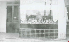
Nichols Family Meat Market
https://search.heritageburnaby.ca/link/archivedescription38155
- Repository
- City of Burnaby Archives
- Date
- 1933 (date of original), copied 1991
- Collection/Fonds
- Burnaby Historical Society fonds
- Description Level
- Item
- Physical Description
- 1 photograph : b&w ; 3.0 x 4.1 cm print on contact sheet 20.6 x 26.8 cm
- Scope and Content
- Photograph of the front window of the Nichols Family Meat Market at 4016 Kingsway (later renumbered 4548 Kingsway). The phone number was Carlton 920.
- Repository
- City of Burnaby Archives
- Date
- 1933 (date of original), copied 1991
- Collection/Fonds
- Burnaby Historical Society fonds
- Subseries
- Burnaby Image Bank subseries
- Physical Description
- 1 photograph : b&w ; 3.0 x 4.1 cm print on contact sheet 20.6 x 26.8 cm
- Description Level
- Item
- Record No.
- 370-742
- Access Restriction
- No restrictions
- Reproduction Restriction
- No known restrictions
- Accession Number
- BHS1999-03
- Scope and Content
- Photograph of the front window of the Nichols Family Meat Market at 4016 Kingsway (later renumbered 4548 Kingsway). The phone number was Carlton 920.
- Subjects
- Buildings - Commercial - Stores
- Media Type
- Photograph
- Notes
- Title based on contents of photograph
- 1 b&w copy negative accompanying
- Negative has a pink cast
- Geographic Access
- Kingsway
- Street Address
- 4548 Kingsway
- Historic Neighbourhood
- Central Park (Historic Neighbourhood)
- Planning Study Area
- Maywood Area
Images
![Pitman family home, [193-] (date of original), copied 1986 thumbnail](/media/hpo/_Data/_Archives_Images/_Unrestricted/204/204-622.jpg?width=280)
Pitman family home
https://search.heritageburnaby.ca/link/archivedescription35764
- Repository
- City of Burnaby Archives
- Date
- [193-] (date of original), copied 1986
- Collection/Fonds
- Burnaby Historical Society fonds
- Description Level
- Item
- Physical Description
- 1 photograph : b&w ; 12.7 x 17.8 cm print
- Scope and Content
- Photograph of the Pitman family home, 2766 Cassie Avenue (later renumbered 6291 Cassie Avenue), South Burnaby, near the McKay Interurban station.
- Repository
- City of Burnaby Archives
- Date
- [193-] (date of original), copied 1986
- Collection/Fonds
- Burnaby Historical Society fonds
- Subseries
- Pioneer Tales subseries
- Physical Description
- 1 photograph : b&w ; 12.7 x 17.8 cm print
- Description Level
- Item
- Record No.
- 204-622
- Access Restriction
- No restrictions
- Reproduction Restriction
- No known restrictions
- Accession Number
- BHS1988-03
- Scope and Content
- Photograph of the Pitman family home, 2766 Cassie Avenue (later renumbered 6291 Cassie Avenue), South Burnaby, near the McKay Interurban station.
- Subjects
- Buildings - Residential - Houses
- Media Type
- Photograph
- Notes
- Title based on contents of photograph
- Geographic Access
- Cassie Avenue
- Street Address
- 6291 Cassie Avenue
- Historic Neighbourhood
- Central Park (Historic Neighbourhood)
- Planning Study Area
- Maywood Area
Images
![Pitman family home, [193-] (date of original), copied 1986 thumbnail](/media/hpo/_Data/_Archives_Images/_Unrestricted/204/204-622.jpg)
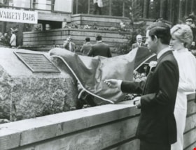
Prince Charles and Princess Diana
https://search.heritageburnaby.ca/link/archivedescription36619
- Repository
- City of Burnaby Archives
- Date
- 1986
- Collection/Fonds
- Burnaby Historical Society fonds
- Description Level
- Item
- Physical Description
- 1 photograph : b&w ; 18.5 x 24.5 cm
- Scope and Content
- Photograph of the Prince and Princess of Wales unveiling a plaque at Central Park.
- Repository
- City of Burnaby Archives
- Date
- 1986
- Collection/Fonds
- Burnaby Historical Society fonds
- Subseries
- Gavel Historical Society subseries
- Physical Description
- 1 photograph : b&w ; 18.5 x 24.5 cm
- Description Level
- Item
- Record No.
- 311-001
- Access Restriction
- No restrictions
- Reproduction Restriction
- Reproduce for fair dealing purposes only
- Accession Number
- BHS1994-03
- Scope and Content
- Photograph of the Prince and Princess of Wales unveiling a plaque at Central Park.
- Subjects
- Events - Royal Visits
- Ceremonies
- Media Type
- Photograph
- Photographer
- Harrison, Jim
- Notes
- Title based on contents of photograph
- Geographic Access
- Central Park
- Imperial Street
- Street Address
- 3883 Imperial Street
- Historic Neighbourhood
- Central Park (Historic Neighbourhood)
- Planning Study Area
- Maywood Area
Images

![Rae Weir clearing land, [193-] (date of original), copied 1986 thumbnail](/media/hpo/_Data/_Archives_Images/_Unrestricted/204/204-173.jpg?width=280)
Rae Weir clearing land
https://search.heritageburnaby.ca/link/archivedescription35316
- Repository
- City of Burnaby Archives
- Date
- [193-] (date of original), copied 1986
- Collection/Fonds
- Burnaby Historical Society fonds
- Description Level
- Item
- Physical Description
- 1 photograph : b&w ; 12.7 x 17.8 cm print
- Scope and Content
- Photograph of Rae Weir clearing a lot on Jubilee Avenue with a D4 Caterpillar bulldozer. Rae Weir owned Jubilee Fuel and Transfer which did everything from clearing lots to excavating basements to delivering and selling fuels.
- Repository
- City of Burnaby Archives
- Date
- [193-] (date of original), copied 1986
- Collection/Fonds
- Burnaby Historical Society fonds
- Subseries
- Pioneer Tales subseries
- Physical Description
- 1 photograph : b&w ; 12.7 x 17.8 cm print
- Description Level
- Item
- Record No.
- 204-173
- Access Restriction
- No restrictions
- Reproduction Restriction
- No known restrictions
- Accession Number
- BHS1988-03
- Scope and Content
- Photograph of Rae Weir clearing a lot on Jubilee Avenue with a D4 Caterpillar bulldozer. Rae Weir owned Jubilee Fuel and Transfer which did everything from clearing lots to excavating basements to delivering and selling fuels.
- Media Type
- Photograph
- Notes
- Title based on contents of photograph
- Geographic Access
- Jubilee Avenue
- Historic Neighbourhood
- Central Park (Historic Neighbourhood)
- Planning Study Area
- Maywood Area
Images
![Rae Weir clearing land, [193-] (date of original), copied 1986 thumbnail](/media/hpo/_Data/_Archives_Images/_Unrestricted/204/204-173.jpg)
![Richards family home on McKay Avenue, [1938] (date of original), copied 1992 thumbnail](/media/hpo/_Data/_Archives_Images/_Unrestricted/315/315-085.jpg?width=280)
Richards family home on McKay Avenue
https://search.heritageburnaby.ca/link/archivedescription36730
- Repository
- City of Burnaby Archives
- Date
- [1938] (date of original), copied 1992
- Collection/Fonds
- Burnaby Historical Society fonds
- Description Level
- Item
- Physical Description
- 1 photograph : b&w ; 5.4 x 10.7 cm print
- Scope and Content
- Photograph of the Richards family home on McKay Avenue, halfway between Kingsway and the streetcar tracks. Three or four children are standing on the porch.
- Repository
- City of Burnaby Archives
- Date
- [1938] (date of original), copied 1992
- Collection/Fonds
- Burnaby Historical Society fonds
- Subseries
- Burnaby Centennial Anthology subseries
- Physical Description
- 1 photograph : b&w ; 5.4 x 10.7 cm print
- Description Level
- Item
- Record No.
- 315-085
- Access Restriction
- No restrictions
- Reproduction Restriction
- No known restrictions
- Accession Number
- BHS1994-04
- Scope and Content
- Photograph of the Richards family home on McKay Avenue, halfway between Kingsway and the streetcar tracks. Three or four children are standing on the porch.
- Subjects
- Buildings - Residential - Houses
- Media Type
- Photograph
- Notes
- Title based on contents of photograph
- Geographic Access
- McKay Avenue
- Kingsway
- Historic Neighbourhood
- Central Park (Historic Neighbourhood)
- Planning Study Area
- Maywood Area
Images
![Richards family home on McKay Avenue, [1938] (date of original), copied 1992 thumbnail](/media/hpo/_Data/_Archives_Images/_Unrestricted/315/315-085.jpg)

Roof Collapse at Metrotown Save-on-Foods
https://search.heritageburnaby.ca/link/museumdescription1166
- Repository
- Burnaby Village Museum
- Date
- April 1988
- Collection/Fonds
- Burnaby Village Museum Photograph collection
- Description Level
- Item
- Physical Description
- 1 photograph : col. 19.5 x 24.5 cm
- Scope and Content
- Aerial photograph of the aftermath of the Save-on-Foods roof collapse at Metrotown on April 23, 1988. The rooftop parking lot has caved into the store along with the cars parked in that section. Workmen and police officers in uniforms are at the parking lot.
- Repository
- Burnaby Village Museum
- Collection/Fonds
- Burnaby Village Museum Photograph collection
- Description Level
- Item
- Physical Description
- 1 photograph : col. 19.5 x 24.5 cm
- Scope and Content
- Aerial photograph of the aftermath of the Save-on-Foods roof collapse at Metrotown on April 23, 1988. The rooftop parking lot has caved into the store along with the cars parked in that section. Workmen and police officers in uniforms are at the parking lot.
- Geographic Access
- Kingsway
- Street Address
- 4800 Kingsway
- Accession Code
- BV992.51.1
- Access Restriction
- Restricted access
- Reproduction Restriction
- May be restricted by third party rights
- Date
- April 1988
- Media Type
- Photograph
- Historic Neighbourhood
- Central Park (Historic Neighbourhood)
- Planning Study Area
- Maywood Area
- Scan Resolution
- 600
- Scan Date
- 01-Jun-09
- Scale
- 100
- Photographer
- Hodge, Craig
- Notes
- Title based on contents of photograph
Images

![Royal Bank of Canada, Kingsway branch, [January 1930] thumbnail](/media/hpo/_Data/_BVM_Images/2018/2018_0043_0001_001.jpg?width=280)
Royal Bank of Canada, Kingsway branch
https://search.heritageburnaby.ca/link/museumdescription9775
- Repository
- Burnaby Village Museum
- Date
- [January 1930]
- Collection/Fonds
- Burnaby Village Museum Photograph collection
- Description Level
- Item
- Physical Description
- 1 photograph : b&w ; 16.5 x 23 cm print
- Scope and Content
- Photograph of the Royal Bank of Canada branch located on Kingsway and McKay in Burnaby. Telephone visible in foreground and a post labelled "KINGSWAY" is on left foreground, at corner of street.
- Repository
- Burnaby Village Museum
- Collection/Fonds
- Burnaby Village Museum Photograph collection
- Description Level
- Item
- Physical Description
- 1 photograph : b&w ; 16.5 x 23 cm print
- Scope and Content
- Photograph of the Royal Bank of Canada branch located on Kingsway and McKay in Burnaby. Telephone visible in foreground and a post labelled "KINGSWAY" is on left foreground, at corner of street.
- Subjects
- Buildings - Commercial - Banks
- Names
- Royal Bank of Canada
- Geographic Access
- Kingsway
- McKay Avenue
- Accession Code
- BV018.43.1
- Access Restriction
- Restricted access
- Reproduction Restriction
- May be restricted by third party rights
- Date
- [January 1930]
- Media Type
- Photograph
- Historic Neighbourhood
- Central Park (Historic Neighbourhood)
- Planning Study Area
- Maywood Area
- Marlborough Area
- Scan Resolution
- 300
- Scan Date
- 10-Jan-2019
- Scale
- 96
- Notes
- Title based on contents of photograph
- Note on verso of photograph reads: "The Royal Bank of Canada Archvies 78-156/ #89"
Images
![Royal Bank of Canada, Kingsway branch, [January 1930] thumbnail](/media/hpo/_Data/_BVM_Images/2018/2018_0043_0001_001.jpg)
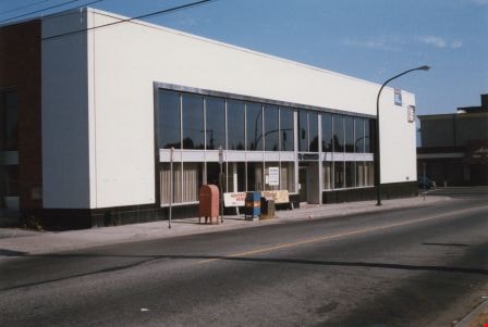
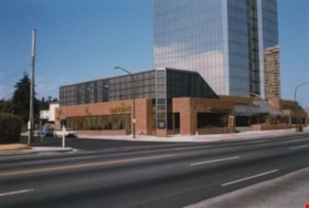
Royal Bank on Kingsway at Kathleen Avenue
https://search.heritageburnaby.ca/link/archivedescription36468
- Repository
- City of Burnaby Archives
- Date
- July 1985
- Collection/Fonds
- Burnaby Historical Society fonds
- Description Level
- Item
- Physical Description
- 1 photograph : col. ; 15 x 10 cm
- Scope and Content
- Photograph of the east side of Royal Bank building on Kingsway at Kathleen Avenue. The high-rise in the background is across Kingsway, on the north side. The bank moved two blocks east from McKay Avenue to this new location.
- Repository
- City of Burnaby Archives
- Date
- July 1985
- Collection/Fonds
- Burnaby Historical Society fonds
- Subseries
- Vera Jackson Pel subseries
- Physical Description
- 1 photograph : col. ; 15 x 10 cm
- Description Level
- Item
- Record No.
- 274-005
- Access Restriction
- No restrictions
- Reproduction Restriction
- Reproduce for fair dealing purposes only
- Accession Number
- BHS1992-04
- Scope and Content
- Photograph of the east side of Royal Bank building on Kingsway at Kathleen Avenue. The high-rise in the background is across Kingsway, on the north side. The bank moved two blocks east from McKay Avenue to this new location.
- Subjects
- Buildings - Commercial - Banks
- Names
- Royal Bank of Canada
- Media Type
- Photograph
- Notes
- Title based on contents of photograph
- Geographic Access
- Kathleen Avenue
- Kingsway
- Street Address
- 4370 Kingsway
- Historic Neighbourhood
- Central Park (Historic Neighbourhood)
- Planning Study Area
- Maywood Area
Images
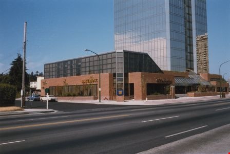
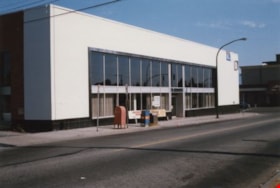
Royal Bank on Kingsway at Kathleen Avenue
https://search.heritageburnaby.ca/link/archivedescription36469
- Repository
- City of Burnaby Archives
- Date
- July 1985
- Collection/Fonds
- Burnaby Historical Society fonds
- Description Level
- Item
- Physical Description
- 1 photograph : col. ; 10 x 15 cm
- Scope and Content
- Photograph of the Royal Bank building on Kingsway at Kathleen Avenue. The bank moved two blocks east from McKay Avenue to this new location.
- Repository
- City of Burnaby Archives
- Date
- July 1985
- Collection/Fonds
- Burnaby Historical Society fonds
- Subseries
- Vera Jackson Pel subseries
- Physical Description
- 1 photograph : col. ; 10 x 15 cm
- Description Level
- Item
- Record No.
- 274-006
- Access Restriction
- No restrictions
- Reproduction Restriction
- Reproduce for fair dealing purposes only
- Accession Number
- BHS1992-04
- Scope and Content
- Photograph of the Royal Bank building on Kingsway at Kathleen Avenue. The bank moved two blocks east from McKay Avenue to this new location.
- Subjects
- Buildings - Commercial - Banks
- Names
- Royal Bank of Canada
- Media Type
- Photograph
- Notes
- Title based on contents of photograph
- Geographic Access
- Kathleen Avenue
- Kingsway
- Street Address
- 4370 Kingsway
- Historic Neighbourhood
- Central Park (Historic Neighbourhood)
- Planning Study Area
- Maywood Area
Images

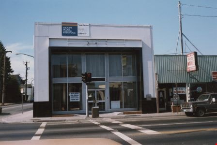
Royal Bank on Kingsway at McKay Avenue
https://search.heritageburnaby.ca/link/archivedescription36464
- Repository
- City of Burnaby Archives
- Date
- July 1985
- Collection/Fonds
- Burnaby Historical Society fonds
- Description Level
- Item
- Physical Description
- 1 photograph : col. ; 10 x 15 cm
- Scope and Content
- Photograph of the front of the former Royal Bank building on Kingsway at McKay Avenue. Vera Jackson Pel worked at this branch of the Royal Bank from 1944 until 1952.
- Repository
- City of Burnaby Archives
- Date
- July 1985
- Collection/Fonds
- Burnaby Historical Society fonds
- Subseries
- Vera Jackson Pel subseries
- Physical Description
- 1 photograph : col. ; 10 x 15 cm
- Description Level
- Item
- Record No.
- 274-001
- Access Restriction
- No restrictions
- Reproduction Restriction
- Reproduce for fair dealing purposes only
- Accession Number
- BHS1992-04
- Scope and Content
- Photograph of the front of the former Royal Bank building on Kingsway at McKay Avenue. Vera Jackson Pel worked at this branch of the Royal Bank from 1944 until 1952.
- Subjects
- Buildings - Commercial - Banks
- Names
- Royal Bank of Canada
- Media Type
- Photograph
- Notes
- Title based on contents of photograph
- Geographic Access
- Kingsway
- McKay Avenue
- Historic Neighbourhood
- Central Park (Historic Neighbourhood)
- Planning Study Area
- Maywood Area
Images
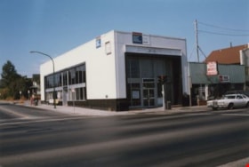
Royal Bank on Kingsway at McKay Avenue
https://search.heritageburnaby.ca/link/archivedescription36465
- Repository
- City of Burnaby Archives
- Date
- July 1985
- Collection/Fonds
- Burnaby Historical Society fonds
- Description Level
- Item
- Physical Description
- 1 photograph : col. ; 10 x 15 cm
- Scope and Content
- Photograph of the former Royal Bank building on Kingsway at McKay Avenue, taken from Kingsway, looking up McKay Avenue. Vera Jackson Pel worked at this branch of the Royal Bank from 1944 until 1952.
- Repository
- City of Burnaby Archives
- Date
- July 1985
- Collection/Fonds
- Burnaby Historical Society fonds
- Subseries
- Vera Jackson Pel subseries
- Physical Description
- 1 photograph : col. ; 10 x 15 cm
- Description Level
- Item
- Record No.
- 274-002
- Access Restriction
- No restrictions
- Reproduction Restriction
- Reproduce for fair dealing purposes only
- Accession Number
- BHS1992-04
- Scope and Content
- Photograph of the former Royal Bank building on Kingsway at McKay Avenue, taken from Kingsway, looking up McKay Avenue. Vera Jackson Pel worked at this branch of the Royal Bank from 1944 until 1952.
- Subjects
- Buildings - Commercial - Banks
- Names
- Royal Bank of Canada
- Media Type
- Photograph
- Notes
- Title based on contents of photograph
- Geographic Access
- Kingsway
- McKay Avenue
- Historic Neighbourhood
- Central Park (Historic Neighbourhood)
- Planning Study Area
- Maywood Area
Images

Royal Bank on Kingsway at McKay Avenue
https://search.heritageburnaby.ca/link/archivedescription36466
- Repository
- City of Burnaby Archives
- Date
- July 1985
- Collection/Fonds
- Burnaby Historical Society fonds
- Description Level
- Item
- Physical Description
- 1 photograph : col. ; 10 x 15 cm
- Scope and Content
- Photograph of the east side of the former Royal Bank building on Kingsway at McKay Avenue. This side faces onto McKay Avenue. Vera Jackson Pel worked at this branch of the Royal Bank from 1944 until 1952.
- Repository
- City of Burnaby Archives
- Date
- July 1985
- Collection/Fonds
- Burnaby Historical Society fonds
- Subseries
- Vera Jackson Pel subseries
- Physical Description
- 1 photograph : col. ; 10 x 15 cm
- Description Level
- Item
- Record No.
- 274-003
- Access Restriction
- No restrictions
- Reproduction Restriction
- Reproduce for fair dealing purposes only
- Accession Number
- BHS1992-04
- Scope and Content
- Photograph of the east side of the former Royal Bank building on Kingsway at McKay Avenue. This side faces onto McKay Avenue. Vera Jackson Pel worked at this branch of the Royal Bank from 1944 until 1952.
- Subjects
- Buildings - Commercial - Banks
- Names
- Royal Bank of Canada
- Media Type
- Photograph
- Notes
- Title based on contents of photograph
- Geographic Access
- Kingsway
- McKay Avenue
- Historic Neighbourhood
- Central Park (Historic Neighbourhood)
- Planning Study Area
- Maywood Area
Images