Narrow Results By
Subject
- Accidents 1
- Accidents - Automobile Accidents 1
- Advertising Medium 3
- Advertising Medium - Signs and Signboards 40
- Aerial Photographs 7
- Agricultural Tools and Equipment - Plows 1
- Agriculture - Crops 4
- Agriculture - Farms 6
- Agriculture - Fruit and Berries 1
- Agriculture - Orchards 1
- Animals 3
- Animals - Birds 1

Central Park Neighbourhood
https://search.heritageburnaby.ca/link/landmark751
- Repository
- Burnaby Heritage Planning
- Associated Dates
- 1905-1924
- Heritage Value
- In 1906, Maxwell Smith, President of the Central Park Farmer's Institute gave a speech in which he commented on the growth of this district and its ideal location during the boom years after 1905. He said: "Central Park is destined to become the epicentre of a great commercial metropolis, when Vancouver and New Westminster will have both expanded and prospered until they meet and fill up the intervening distances with residences of a new city, greater than few can now imagine, even in their wildest flights of fancy...we are proud of the two cities that lie on either side of us but they are, but mere hamlets compared with the great city that is to be on this peninsula. The time is coming when there will be one vast city, one commercial metropolis, and Central Park will be the heart of it."
- Historic Neighbourhood
- Central Park (Historic Neighbourhood)
- Planning Study Area
- Maywood Area
Images


Kingsway
https://search.heritageburnaby.ca/link/landmark775
- Repository
- Burnaby Heritage Planning
- Associated Dates
- 1913
- Heritage Value
- The years 1911-1912 saw great expansion and settlement in Burnaby and large public works projects were undertaken to service the growing community. One project that was determined to be a necessity was the construction of a proper highway between New Westminster and Vancouver. The Province and the Municipality agreed to share the costs of construction (with Burnaby paying 25% and the Province 75%) and so Kingsway was built to improve the current Vancouver Road. The road was named after the famous King's Way in London, England.
- Historic Neighbourhood
- Central Park (Historic Neighbourhood)
- Edmonds (Historic Neighbourhood)
- Planning Study Area
- Maywood Area
- Marlborough Area
- Windsor Area
- Kingsway-Beresford Area
- Stride Avenue Area
- Edmonds Area
Images


Maywood Neighbourhood
https://search.heritageburnaby.ca/link/landmark801
- Repository
- Burnaby Heritage Planning
- Associated Dates
- 1955-2008
- Heritage Value
- Burnaby's Maywood Neighbourhood consists of the Metrotown Town Centre - one of four Town Centres in the City. Metrotown is one of the region's most developed and fastest growing centres. It is served by the first SkyTrain line developed in the mid-1980s and anchored by B.C.'s largest shopping and entertainment complex. As an older centre that has progressively added new developments over the years, Metrotown offers a range of housing types and tenures from three-storey walk-up apartments to modern residential towers.
- Historic Neighbourhood
- Central Park (Historic Neighbourhood)
- Planning Study Area
- Maywood Area
Images


Maywood Elementary School
https://search.heritageburnaby.ca/link/landmark812
- Repository
- Burnaby Heritage Planning
- Geographic Access
- Imperial Street
- Associated Dates
- 1962
- Heritage Value
- Located between Nelson and Suncrest Schools, Maywood Elementary School was built in 1962 and helped eased the increasing enrolments at these other schools. Like other schools of this period, Maywood was built on one level with no basement and no high stairs. The classrooms were built in a line which could be easily added to as required. Additions to the original structure were completed in 1964, 1966, 1967, 1971, 1972. Fires at the school in 1979 and 1989 caused extensive damage and required partial reconstruction of the building.
- Historic Neighbourhood
- Central Park (Historic Neighbourhood)
- Planning Study Area
- Maywood Area
- Street Address
- 4567 Imperial Street
- Street View URL
- Google Maps Street View
Images


Metrotown
https://search.heritageburnaby.ca/link/landmark817
- Repository
- Burnaby Heritage Planning
- Geographic Access
- Kingsway
- Associated Dates
- 1986
- Heritage Value
- Although the idea for Metrotown was first expressed in the 1970s, the building itself opened in 1986 and was soon served by the Expo Line of the new SkyTrain system. In the ensuing twenty years, the complex developed into three distinct but adjoining malls - Metropolis at Metrotown, Metrotown Centre, and Station Square. Today, Metrotown serves as the city’s commercial and retail anchor. The mall also includes two large office towers, which by 2001 were home to the head offices for Shaw Cable and TransLink.
- Historic Neighbourhood
- Central Park (Historic Neighbourhood)
- Planning Study Area
- Maywood Area
- Street Address
- 4700 Kingsway
- Street View URL
- Google Maps Street View
Images


Swangard Stadium
https://search.heritageburnaby.ca/link/landmark818
- Repository
- Burnaby Heritage Planning
- Geographic Access
- Imperial Street
- Associated Dates
- 1969
- Heritage Value
- On 26 April 1969 Swangard Stadium held its official opening. Named after Vancouver Sun former Managing Editor, Erwin Swangard, the stadium was funded entirely from private donations and civic and provincial grants.
- Historic Neighbourhood
- Central Park (Historic Neighbourhood)
- Planning Study Area
- Maywood Area
- Street Address
- 3883 Imperial Street
Images


Apartment at Maywood and Patterson
https://search.heritageburnaby.ca/link/archivedescription79030
- Repository
- City of Burnaby Archives
- Date
- September 22, 1976
- Collection/Fonds
- Burnaby Public Library Contemporary Visual Archive Project
- Description Level
- Item
- Physical Description
- 1 photograph : b&w ; 11 x 16 cm mounted on cardboard
- Scope and Content
- Photograph shows an apartment building called Times Square located at the corner of Maywood Street and Patterson Avenue.
- Repository
- City of Burnaby Archives
- Date
- September 22, 1976
- Collection/Fonds
- Burnaby Public Library Contemporary Visual Archive Project
- Physical Description
- 1 photograph : b&w ; 11 x 16 cm mounted on cardboard
- Description Level
- Item
- Record No.
- 556-101
- Access Restriction
- No restrictions
- Reproduction Restriction
- Reproduce for fair dealing purposes only
- Accession Number
- 2013-13
- Scope and Content
- Photograph shows an apartment building called Times Square located at the corner of Maywood Street and Patterson Avenue.
- Subjects
- Buildings - Residential - Apartments
- Media Type
- Photograph
- Photographer
- McCarron, John
- Notes
- Scope note taken directly from BPL photograph description.
- 1 b&w copy negative : 10 x 12.5 cm accompanying
- Geographic Access
- Maywood Street
- Patterson Avenue
- Historic Neighbourhood
- Central Park (Historic Neighbourhood)
- Planning Study Area
- Maywood Area
Images

Royal Bank of Canada
https://search.heritageburnaby.ca/link/archivedescription79078
- Repository
- City of Burnaby Archives
- Date
- September 15, 1976
- Collection/Fonds
- Burnaby Public Library Contemporary Visual Archive Project
- Description Level
- Item
- Physical Description
- 1 photograph : b&w ; 11 x 16 cm mounted on cardboard
- Scope and Content
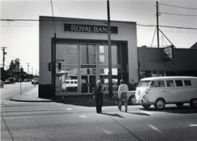
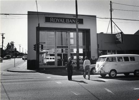
- Photograph shows the Royal Bank of Canada at 4568 Kingsway on the corner of Kingsway and McKay Avenue.
- Repository
- City of Burnaby Archives
- Date
- September 15, 1976
- Collection/Fonds
- Burnaby Public Library Contemporary Visual Archive Project
- Physical Description
- 1 photograph : b&w ; 11 x 16 cm mounted on cardboard
- Description Level
- Item
- Record No.
- 556-138
- Access Restriction
- No restrictions
- Reproduction Restriction
- Reproduce for fair dealing purposes only
- Accession Number
- 2013-13
- Scope and Content
- Photograph shows the Royal Bank of Canada at 4568 Kingsway on the corner of Kingsway and McKay Avenue.
- Subjects
- Buildings - Commercial - Banks
- Names
- Royal Bank of Canada
- Media Type
- Photograph
- Photographer
- McCarron, John
- Notes
- Scope note taken directly from BPL photograph description.
- 1 b&w copy negative : 10 x 12.5 cm accompanying
- Geographic Access
- Kingsway
- Street Address
- 4568 Kingsway
- Historic Neighbourhood
- Central Park (Historic Neighbourhood)
- Planning Study Area
- Maywood Area
Images

Tommy's Produce
https://search.heritageburnaby.ca/link/archivedescription79096
- Repository
- City of Burnaby Archives
- Date
- September 15, 1976
- Collection/Fonds
- Burnaby Public Library Contemporary Visual Archive Project
- Description Level
- Item
- Physical Description
- 1 photograph : b&w ; 11 x 16 cm mounted on cardboard
- Scope and Content
- Photograph shows Tommy's Produce at 4520 Kingsway between Willingdon and Cassie Avenue. The sign for the Dragon Inn can be seen in the background.
- Repository
- City of Burnaby Archives
- Date
- September 15, 1976
- Collection/Fonds
- Burnaby Public Library Contemporary Visual Archive Project
- Physical Description
- 1 photograph : b&w ; 11 x 16 cm mounted on cardboard
- Description Level
- Item
- Record No.
- 556-149
- Access Restriction
- No restrictions
- Reproduction Restriction
- Reproduce for fair dealing purposes only
- Accession Number
- 2013-13
- Scope and Content
- Photograph shows Tommy's Produce at 4520 Kingsway between Willingdon and Cassie Avenue. The sign for the Dragon Inn can be seen in the background.
- Names
- Tommy's Produce
- Media Type
- Photograph
- Photographer
- McCarron, John
- Notes
- Scope note taken directly from BPL photograph description.
- 1 b&w copy negative : 10 x 12.5 cm accompanying
- Geographic Access
- Kingsway
- Street Address
- 4520 Kingsway
- Historic Neighbourhood
- Central Park (Historic Neighbourhood)
- Planning Study Area
- Maywood Area
Images


Henry's Foodland
https://search.heritageburnaby.ca/link/archivedescription79102
- Repository
- City of Burnaby Archives
- Date
- September 15, 1976
- Collection/Fonds
- Burnaby Public Library Contemporary Visual Archive Project
- Description Level
- Item
- Physical Description
- 1 photograph : b&w ; 11 x 16 cm mounted on cardboard
- Scope and Content
- Photograph shows the interior of Henry's Foodland at 4530 Kingsway, near Cassie Avenue. The building was constructed around 1925 with residences upstairs. The man in the photograph is unidentified.
- Repository
- City of Burnaby Archives
- Date
- September 15, 1976
- Collection/Fonds
- Burnaby Public Library Contemporary Visual Archive Project
- Physical Description
- 1 photograph : b&w ; 11 x 16 cm mounted on cardboard
- Description Level
- Item
- Record No.
- 556-153
- Access Restriction
- No restrictions
- Reproduction Restriction
- Reproduce for fair dealing purposes only
- Accession Number
- 2013-13
- Scope and Content
- Photograph shows the interior of Henry's Foodland at 4530 Kingsway, near Cassie Avenue. The building was constructed around 1925 with residences upstairs. The man in the photograph is unidentified.
- Names
- Henry's Foodland
- Media Type
- Photograph
- Photographer
- McCarron, John
- Notes
- Scope note taken directly from BPL photograph description.
- 1 b&w copy negative : 10 x 12.5 cm accompanying
- Geographic Access
- Kingsway
- Street Address
- 4530 Kingsway
- Historic Neighbourhood
- Central Park (Historic Neighbourhood)
- Planning Study Area
- Maywood Area
Images

Simpson-Sears
https://search.heritageburnaby.ca/link/archivedescription79135
- Repository
- City of Burnaby Archives
- Date
- September 13, 1976
- Collection/Fonds
- Burnaby Public Library Contemporary Visual Archive Project
- Description Level
- Item
- Physical Description
- 1 photograph : b&w ; 11 x 16 cm mounted on cardboard
- Scope and Content
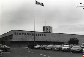
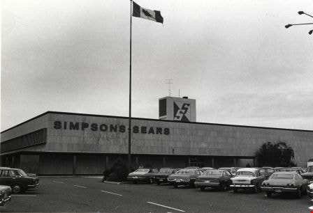
- Photograph shows Simpson-Sears store at 4750 Kingsway.
- Repository
- City of Burnaby Archives
- Date
- September 13, 1976
- Collection/Fonds
- Burnaby Public Library Contemporary Visual Archive Project
- Physical Description
- 1 photograph : b&w ; 11 x 16 cm mounted on cardboard
- Description Level
- Item
- Record No.
- 556-176
- Access Restriction
- No restrictions
- Reproduction Restriction
- Reproduce for fair dealing purposes only
- Accession Number
- 2013-13
- Scope and Content
- Photograph shows Simpson-Sears store at 4750 Kingsway.
- Subjects
- Buildings - Commercial - Stores
- Names
- Simpsons-Sears Limited
- Media Type
- Photograph
- Photographer
- McCarron, John
- Notes
- Scope note taken directly from BPL photograph description.
- 1 b&w copy negative : 10 x 12.5 cm accompanying
- Geographic Access
- Kingsway
- Street Address
- 4750 Kingsway
- Historic Neighbourhood
- Central Park (Historic Neighbourhood)
- Planning Study Area
- Maywood Area
Images

McKay Barbers
https://search.heritageburnaby.ca/link/archivedescription79177
- Repository
- City of Burnaby Archives
- Date
- September 15, 1976
- Collection/Fonds
- Burnaby Public Library Contemporary Visual Archive Project
- Description Level
- Item
- Physical Description
- 1 photograph : b&w ; 11 x 16 cm mounted on cardboard
- Scope and Content
- Photograph shows signs in the window of McKay Barbers advertising prices for haircuts. The shop, on Kingsway near McKay, was built in the 1920s originally as part of the grocery store next door and was a bakery for a time. At the time of the photograph, it had been a barber shop for 42 years.
- Repository
- City of Burnaby Archives
- Date
- September 15, 1976
- Collection/Fonds
- Burnaby Public Library Contemporary Visual Archive Project
- Physical Description
- 1 photograph : b&w ; 11 x 16 cm mounted on cardboard
- Description Level
- Item
- Record No.
- 556-191
- Access Restriction
- No restrictions
- Reproduction Restriction
- Reproduce for fair dealing purposes only
- Accession Number
- 2013-13
- Scope and Content
- Photograph shows signs in the window of McKay Barbers advertising prices for haircuts. The shop, on Kingsway near McKay, was built in the 1920s originally as part of the grocery store next door and was a bakery for a time. At the time of the photograph, it had been a barber shop for 42 years.
- Names
- McKay Barber Shop
- Media Type
- Photograph
- Photographer
- McCarron, John
- Notes
- Scope note taken directly from BPL photograph description.
- 1 b&w copy negative : 10 x 12.5 cm accompanying
- Geographic Access
- McKay Avenue
- Historic Neighbourhood
- Central Park (Historic Neighbourhood)
- Planning Study Area
- Maywood Area
Images

![South Burnaby Neighbourhood House opening, [1999] thumbnail](/media/hpo/_Data/_Archives_Images/_Unrestricted/535/535-3338.jpg?width=280)
South Burnaby Neighbourhood House opening
https://search.heritageburnaby.ca/link/archivedescription98271
- Repository
- City of Burnaby Archives
- Date
- [1999]
- Collection/Fonds
- Burnaby NewsLeader photograph collection
- Description Level
- Item
- Physical Description
- 1 photograph (tiff) : col.
- Scope and Content
- Photograph of staff member Kimberly Barwich posing outside the South Burnaby Neighbourhood House with a handful of literature on the occasion of its opening.
- Repository
- City of Burnaby Archives
- Date
- [1999]
- Collection/Fonds
- Burnaby NewsLeader photograph collection
- Physical Description
- 1 photograph (tiff) : col.
- Description Level
- Item
- Record No.
- 535-3338
- Access Restriction
- No restrictions
- Reproduction Restriction
- No restrictions
- Accession Number
- 2018-12
- Scope and Content
- Photograph of staff member Kimberly Barwich posing outside the South Burnaby Neighbourhood House with a handful of literature on the occasion of its opening.
- Subjects
- Organizations - Charities
- Public Services
- Media Type
- Photograph
- Notes
- Title based on original file name
- Collected by editorial for use in a September 1999 issue of the Burnaby NewsLeader
- Historic Neighbourhood
- Central Park (Historic Neighbourhood)
- Planning Study Area
- Maywood Area
Images
![South Burnaby Neighbourhood House opening, [1999] thumbnail](/media/hpo/_Data/_Archives_Images/_Unrestricted/535/535-3338.jpg)
![Terry Fox Run at Swangard Stadium, [1999] thumbnail](/media/hpo/_Data/_Archives_Images/_Unrestricted/535/535-3342-1.jpg?width=280)
Terry Fox Run at Swangard Stadium
https://search.heritageburnaby.ca/link/archivedescription98318
- Repository
- City of Burnaby Archives
- Date
- [1999]
- Collection/Fonds
- Burnaby NewsLeader photograph collection
- Description Level
- File
- Physical Description
- 3 photographs (tiff) : col.
- Scope and Content
- File contains photographs of the Terry Fox Run event at Swangard Stadium. Photographs depict runners Shawna Soles and Kevin Smyth warming up before the race and unidentified participants starting the race on the stadium's track.
- Repository
- City of Burnaby Archives
- Date
- [1999]
- Collection/Fonds
- Burnaby NewsLeader photograph collection
- Physical Description
- 3 photographs (tiff) : col.
- Description Level
- File
- Record No.
- 535-3342
- Access Restriction
- No restrictions
- Reproduction Restriction
- No restrictions
- Accession Number
- 2018-12
- Scope and Content
- File contains photographs of the Terry Fox Run event at Swangard Stadium. Photographs depict runners Shawna Soles and Kevin Smyth warming up before the race and unidentified participants starting the race on the stadium's track.
- Names
- Swangard Stadium
- Media Type
- Photograph
- Notes
- Title based on caption
- Collected by editorial for use in a September 1999 issue of the Burnaby NewsLeader
- Caption from metadata for 535-3342-1: "Shawna Soles and Kevin Smyth stretch prior to the Terry Fox run. Shawna and Kevin were part of a group of over 100 who took part in the run"
- Caption from metadata for 535-3342-2: "Start of Terry Fox run at Swangard Stadium"
- Caption from metadata for 535-3342-3: "Start of Terry Fox run at Swangard Stadium"
- Geographic Access
- Central Park
- Imperial Street
- Street Address
- 3883 Imperial Street
- Historic Neighbourhood
- Central Park (Historic Neighbourhood)
- Planning Study Area
- Maywood Area
Images
![Terry Fox Run at Swangard Stadium, [1999] thumbnail](/media/hpo/_Data/_Archives_Images/_Unrestricted/535/535-3342-1.jpg)
![Metrotown community police station, [1999] thumbnail](/media/hpo/_Data/_Archives_Images/_Unrestricted/535/535-3344.jpg?width=280)
Metrotown community police station
https://search.heritageburnaby.ca/link/archivedescription98320
- Repository
- City of Burnaby Archives
- Date
- [1999]
- Collection/Fonds
- Burnaby NewsLeader photograph collection
- Description Level
- Item
- Physical Description
- 1 photograph (tiff) : col.
- Scope and Content
- Photograph of Burnaby RCMP officer Doug Wright posing outside of the new community police station in the Metrotown neighbourhood, located in the bottom of a tower on Kingsborough Street. The station officially opened on October 6, 1999.
- Repository
- City of Burnaby Archives
- Date
- [1999]
- Collection/Fonds
- Burnaby NewsLeader photograph collection
- Physical Description
- 1 photograph (tiff) : col.
- Description Level
- Item
- Record No.
- 535-3344
- Access Restriction
- No restrictions
- Reproduction Restriction
- No restrictions
- Accession Number
- 2018-12
- Scope and Content
- Photograph of Burnaby RCMP officer Doug Wright posing outside of the new community police station in the Metrotown neighbourhood, located in the bottom of a tower on Kingsborough Street. The station officially opened on October 6, 1999.
- Media Type
- Photograph
- Photographer
- Bartel, Mario
- Notes
- Title based on caption
- Collected by editorial for use in a September 1999 issue of the Burnaby NewsLeader
- Caption from metadata: "Doug Wright, of Burnaby RCMP, says he'll face unique challenges policing the Metrotown area from the department's newest community policing office in The Crystal."
- Geographic Access
- Kingsborough Street
- Street Address
- 4501 Kingsborough Street
- Historic Neighbourhood
- Central Park (Historic Neighbourhood)
- Planning Study Area
- Maywood Area
Images
![Metrotown community police station, [1999] thumbnail](/media/hpo/_Data/_Archives_Images/_Unrestricted/535/535-3344.jpg)
![Painting the Hilton Hotel, [1999] thumbnail](/media/hpo/_Data/_Archives_Images/_Unrestricted/535/535-3353.jpg?width=280)
Painting the Hilton Hotel
https://search.heritageburnaby.ca/link/archivedescription98343
- Repository
- City of Burnaby Archives
- Date
- [1999]
- Collection/Fonds
- Burnaby NewsLeader photograph collection
- Description Level
- Item
- Physical Description
- 1 photograph (tiff) : col.
- Scope and Content
- Photograph of Krystian Litwinski, a foreman for Concord Painting, painting the awning of the Hilton Hotel in the Crystal in Metrotown before its opening.
- Repository
- City of Burnaby Archives
- Date
- [1999]
- Collection/Fonds
- Burnaby NewsLeader photograph collection
- Physical Description
- 1 photograph (tiff) : col.
- Description Level
- Item
- Record No.
- 535-3353
- Access Restriction
- No restrictions
- Reproduction Restriction
- No restrictions
- Accession Number
- 2018-12
- Scope and Content
- Photograph of Krystian Litwinski, a foreman for Concord Painting, painting the awning of the Hilton Hotel in the Crystal in Metrotown before its opening.
- Names
- Metrotown
- Media Type
- Photograph
- Photographer
- Bartel, Mario
- Notes
- Title based on caption
- Collected by editorial for use in an October 1999 issue of the Burnaby NewsLeader
- Caption from metadata: "Krystian Litwinski, a foreman for Concord Painting, gets the awning over the entrance to the new Hilton Hotel at the Crystal, ready for its opening."
- Geographic Access
- McKay Avenue
- Street Address
- 6083 McKay Avenue
- Historic Neighbourhood
- Central Park (Historic Neighbourhood)
- Planning Study Area
- Maywood Area
Images
![Painting the Hilton Hotel, [1999] thumbnail](/media/hpo/_Data/_Archives_Images/_Unrestricted/535/535-3353.jpg)
![Crystal Ballroom at the Hilton Hotel, [1999] thumbnail](/media/hpo/_Data/_Archives_Images/_Unrestricted/535/535-3362.jpg?width=280)
Crystal Ballroom at the Hilton Hotel
https://search.heritageburnaby.ca/link/archivedescription98352
- Repository
- City of Burnaby Archives
- Date
- [1999]
- Collection/Fonds
- Burnaby NewsLeader photograph collection
- Description Level
- Item
- Physical Description
- 1 photograph (tiff) : col.
- Scope and Content
- Photograph of Simon Mais, the Assistant General Manager of the new Hilton Hotel at the Crystal in the Metrotown area, posing in the hotel's Crystal Ballroom. Other Metrotown towers and a crane are visible in the view in the background.
- Repository
- City of Burnaby Archives
- Date
- [1999]
- Collection/Fonds
- Burnaby NewsLeader photograph collection
- Physical Description
- 1 photograph (tiff) : col.
- Description Level
- Item
- Record No.
- 535-3362
- Access Restriction
- No restrictions
- Reproduction Restriction
- No restrictions
- Accession Number
- 2018-12
- Scope and Content
- Photograph of Simon Mais, the Assistant General Manager of the new Hilton Hotel at the Crystal in the Metrotown area, posing in the hotel's Crystal Ballroom. Other Metrotown towers and a crane are visible in the view in the background.
- Names
- Metrotown
- Media Type
- Photograph
- Photographer
- Bartel, Mario
- Notes
- Title based on caption
- Collected by editorial for use in an October 1999 issue of the Burnaby NewsLeader
- Caption from metadata: "Simon Mais, the Assistant General Manager at the new Hilton Hotel at the Crystal, enjoys the view from the Crystal Ballroom."
- Geographic Access
- McKay Avenue
- Street Address
- 6083 McKay Avenue
- Historic Neighbourhood
- Central Park (Historic Neighbourhood)
- Planning Study Area
- Maywood Area
Images
![Crystal Ballroom at the Hilton Hotel, [1999] thumbnail](/media/hpo/_Data/_Archives_Images/_Unrestricted/535/535-3362.jpg)
![Person viewing large knives in the Metrotown area, [1999] thumbnail](/media/hpo/_Data/_Archives_Images/_Unrestricted/535/535-3387.jpg?width=280)
Person viewing large knives in the Metrotown area
https://search.heritageburnaby.ca/link/archivedescription98377
- Repository
- City of Burnaby Archives
- Date
- [1999]
- Collection/Fonds
- Burnaby NewsLeader photograph collection
- Description Level
- Item
- Physical Description
- 1 photograph (tiff) : col.
- Scope and Content
- Photograph of an unidentified person viewing two large knives and a pole laying across a garbage can in the Metrotown area. Two towers and the SkyTrain tracks are visible behind the person.
- Repository
- City of Burnaby Archives
- Date
- [1999]
- Collection/Fonds
- Burnaby NewsLeader photograph collection
- Physical Description
- 1 photograph (tiff) : col.
- Description Level
- Item
- Record No.
- 535-3387
- Access Restriction
- No restrictions
- Reproduction Restriction
- No restrictions
- Accession Number
- 2018-12
- Scope and Content
- Photograph of an unidentified person viewing two large knives and a pole laying across a garbage can in the Metrotown area. Two towers and the SkyTrain tracks are visible behind the person.
- Names
- Metrotown
- Media Type
- Photograph
- Notes
- Title based on contents of photograph
- Collected by editorial for use in an October 1999 issue of the Burnaby NewsLeader
- Historic Neighbourhood
- Central Park (Historic Neighbourhood)
- Planning Study Area
- Maywood Area
Images
![Person viewing large knives in the Metrotown area, [1999] thumbnail](/media/hpo/_Data/_Archives_Images/_Unrestricted/535/535-3387.jpg)
![Clothes hangers in Metrotown hedges, [1999] thumbnail](/media/hpo/_Data/_Archives_Images/_Unrestricted/535/535-3388.jpg?width=280)
Clothes hangers in Metrotown hedges
https://search.heritageburnaby.ca/link/archivedescription98378
- Repository
- City of Burnaby Archives
- Date
- [1999]
- Collection/Fonds
- Burnaby NewsLeader photograph collection
- Description Level
- Item
- Physical Description
- 1 photograph (tiff) : col.
- Scope and Content
- Photograph of an unidentified person holding up clothes hangers with price tags and squatting in front of a hedge in the Metrotown area.
- Repository
- City of Burnaby Archives
- Date
- [1999]
- Collection/Fonds
- Burnaby NewsLeader photograph collection
- Physical Description
- 1 photograph (tiff) : col.
- Description Level
- Item
- Record No.
- 535-3388
- Access Restriction
- No restrictions
- Reproduction Restriction
- No restrictions
- Accession Number
- 2018-12
- Scope and Content
- Photograph of an unidentified person holding up clothes hangers with price tags and squatting in front of a hedge in the Metrotown area.
- Names
- Metrotown
- Media Type
- Photograph
- Notes
- Title based on original file name
- Collected by editorial for use in an October 1999 issue of the Burnaby NewsLeader
- Historic Neighbourhood
- Central Park (Historic Neighbourhood)
- Planning Study Area
- Maywood Area
Images
![Clothes hangers in Metrotown hedges, [1999] thumbnail](/media/hpo/_Data/_Archives_Images/_Unrestricted/535/535-3388.jpg)
![Person talking to Metrotown police, [1999] thumbnail](/media/hpo/_Data/_Archives_Images/_Unrestricted/535/535-3389.jpg?width=280)
Person talking to Metrotown police
https://search.heritageburnaby.ca/link/archivedescription98379
- Repository
- City of Burnaby Archives
- Date
- [1999]
- Collection/Fonds
- Burnaby NewsLeader photograph collection
- Description Level
- Item
- Physical Description
- 1 photograph (tiff) : col.
- Scope and Content
- Photograph of an unidentified person speaking to an unidentified Burnaby RCMP officer in the Metrotown area. Two towers and the SkyTrain tracks are visible behind the two people.
- Repository
- City of Burnaby Archives
- Date
- [1999]
- Collection/Fonds
- Burnaby NewsLeader photograph collection
- Physical Description
- 1 photograph (tiff) : col.
- Description Level
- Item
- Record No.
- 535-3389
- Access Restriction
- No restrictions
- Reproduction Restriction
- No restrictions
- Accession Number
- 2018-12
- Scope and Content
- Photograph of an unidentified person speaking to an unidentified Burnaby RCMP officer in the Metrotown area. Two towers and the SkyTrain tracks are visible behind the two people.
- Media Type
- Photograph
- Notes
- Title based on original file name
- Collected by editorial for use in an October 1999 issue of the Burnaby NewsLeader
- Historic Neighbourhood
- Central Park (Historic Neighbourhood)
- Planning Study Area
- Maywood Area
Images
![Person talking to Metrotown police, [1999] thumbnail](/media/hpo/_Data/_Archives_Images/_Unrestricted/535/535-3389.jpg)