Narrow Results By
Subject
- Advertising Medium - Signs and Signboards 4
- Agriculture - Crops 4
- Agriculture - Farms 4
- Agriculture - Orchards 1
- Animals 1
- Animals - Poultry 3
- Buildings - Commercial 1
- Buildings - Commercial - General Stores 1
- Buildings - Commercial - Restaurants 3
- Buildings - Commercial - Service Stations 1
- Buildings - Commercial - Train Stations 1
- Buildings - Recreational - Bandstands 1
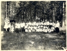
First Burnaby Girl Guide Company in Central Park
https://search.heritageburnaby.ca/link/museumdescription4906
- Repository
- Burnaby Village Museum
- Date
- 1 Jul 1916
- Collection/Fonds
- Burnaby Girl Guides fonds
- Description Level
- Item
- Physical Description
- 1 photograph : sepia ; 16.5 x 21.5 cm
- Scope and Content
- Photograph of the 1st Burnaby Company in Central Park in Burnaby. The girl guides are dressed in white uniforms and are gathered together for a group photograph in a clearing in the woods. One of the girls at the centre of the group is holding a commonwealth flag.
- Repository
- Burnaby Village Museum
- Collection/Fonds
- Burnaby Girl Guides fonds
- Description Level
- Item
- Physical Description
- 1 photograph : sepia ; 16.5 x 21.5 cm
- Scope and Content
- Photograph of the 1st Burnaby Company in Central Park in Burnaby. The girl guides are dressed in white uniforms and are gathered together for a group photograph in a clearing in the woods. One of the girls at the centre of the group is holding a commonwealth flag.
- Names
- Girl Guides of Canada
- Geographic Access
- Central Park
- Accession Code
- BV015.35.264
- Access Restriction
- No restrictions
- Reproduction Restriction
- No known restrictions
- Date
- 1 Jul 1916
- Media Type
- Photograph
- Historic Neighbourhood
- Central Park (Historic Neighbourhood)
- Planning Study Area
- Maywood Area
- Scan Resolution
- 600
- Scan Date
- January 6, 2021
- Scale
- 100
- Notes
- Title based on contents of photograph
- Note in blue ink on verso of photograph reads: "Central Park, Burnaby / July 1, 1916 / 1st Burnaby Company"
- Stamp on verso of photograph reads: "FRANCEL MORKILL / GIRL GUIDE LIBRARY"
- Signature in blue ink on verso of photograph reads: "Amy Leigh"
- Notes in red pencil on verso of photograph read: "8 _ 50%"
- Photograph is a part of scrapbook "Burnaby Girl Guides. -- [1914]-1969, predominant ca. 1920" (BV.015.35.164)
Images

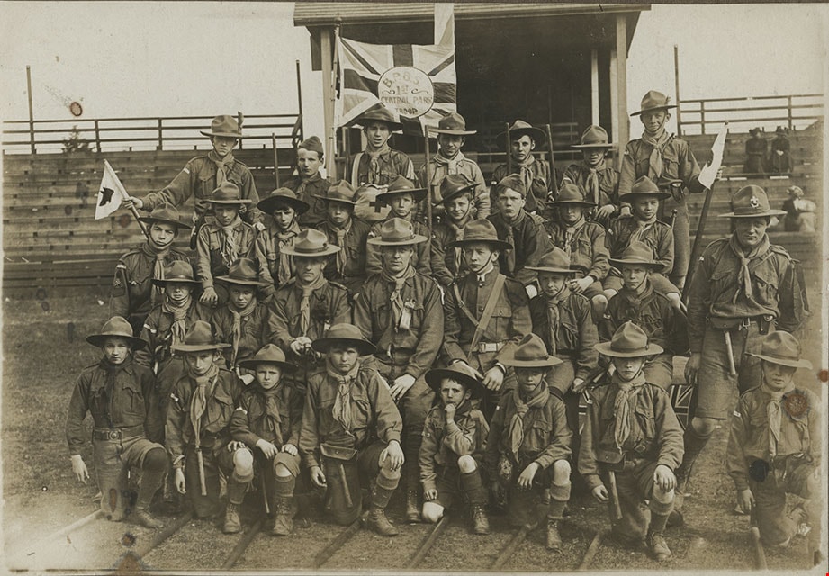
First Central Park B.P. Boy Scouts, 1910
https://search.heritageburnaby.ca/link/museumdescription1055
- Repository
- Burnaby Village Museum
- Date
- 1910
- Collection/Fonds
- Burnaby Village Museum Photograph collection
- Description Level
- Item
- Physical Description
- 1 photograph : b&w ; 12.1 x 17.3 cm mounted on cardboard 22.0 x 27.0 cm
- Scope and Content
- Photograph of the First Central Park troop of Boy Scouts. All but two of them are in uniform, standing at attention. There are 22 boys and 7 men. A man in the centre is holding a flagpole with a Union Jack attached. The Boy Scouts are standing on a cleared field behind which is a building and fores…
- Repository
- Burnaby Village Museum
- Collection/Fonds
- Burnaby Village Museum Photograph collection
- Description Level
- Item
- Physical Description
- 1 photograph : b&w ; 12.1 x 17.3 cm mounted on cardboard 22.0 x 27.0 cm
- Scope and Content
- Photograph of the First Central Park troop of Boy Scouts. All but two of them are in uniform, standing at attention. There are 22 boys and 7 men. A man in the centre is holding a flagpole with a Union Jack attached. The Boy Scouts are standing on a cleared field behind which is a building and forest growth. The location may be Central Park. A caption printed on the bottom front of the frame reads, "First Central Park / B.P. Boy Scou [sic] / 1910." Printed on the lower right front of the frame, "W. Brown, Photo. / New Westminster, B.C."
- Names
- Boy Scouts of Canada
- Geographic Access
- Central Park
- Imperial Street
- Street Address
- 3883 Imperial Street
- Accession Code
- HV973.152.2
- Access Restriction
- No restrictions
- Reproduction Restriction
- No known restrictions
- Date
- 1910
- Media Type
- Photograph
- Historic Neighbourhood
- Central Park (Historic Neighbourhood)
- Planning Study Area
- Maywood Area
- Related Material
- See HV973.152.1 for another photograph of the first central park BP boy scouts.
- Scan Resolution
- 600
- Scan Date
- 2023-06-06
- Photographer
- Brown, William Thomas
- Notes
- Title based on caption of photograph
Images


![First Central Park B.P. Boy Scouts, Central Park, BC, [1910] thumbnail](/media/hpo/_Data/_BVM_Images/1973/1973_0152_0001_001.jpg?width=280)
First Central Park B.P. Boy Scouts, Central Park, BC
https://search.heritageburnaby.ca/link/museumdescription1054
- Repository
- Burnaby Village Museum
- Date
- [1910]
- Collection/Fonds
- Burnaby Village Museum Photograph collection
- Description Level
- Item
- Physical Description
- 1 photograph : sepia ; 12.3 x 17.8 cm mounted on cardboard 22.0 x 27.0 cm
- Scope and Content
- Photograph of the First Central Park Troop of Boy Scouts. They are wearing uniforms and posed outside in front of bleachers at Central Park. There are 28 boys ranging in age from about seven to twelve, and four adults. A boy in the back row is holding a Union Jack with a circle in the middle in whi…
- Repository
- Burnaby Village Museum
- Collection/Fonds
- Burnaby Village Museum Photograph collection
- Description Level
- Item
- Physical Description
- 1 photograph : sepia ; 12.3 x 17.8 cm mounted on cardboard 22.0 x 27.0 cm
- Scope and Content
- Photograph of the First Central Park Troop of Boy Scouts. They are wearing uniforms and posed outside in front of bleachers at Central Park. There are 28 boys ranging in age from about seven to twelve, and four adults. A boy in the back row is holding a Union Jack with a circle in the middle in which is written, "B.P.B.S. / 1st / Central Park / Troop." A caption printed on the bottom front of the frame reads, "First Central Park B.P. Boy Scouts, Central Park, B.C." A annotation on the back of the photo reads, "Mr. Robertson."
- Names
- Boy Scouts of Canada
- Geographic Access
- Imperial Street
- Central Park
- Street Address
- 3883 Imperial Street
- Accession Code
- HV973.152.1
- Access Restriction
- No restrictions
- Reproduction Restriction
- No known restrictions
- Date
- [1910]
- Media Type
- Photograph
- Historic Neighbourhood
- Central Park (Historic Neighbourhood)
- Planning Study Area
- Maywood Area
- Related Material
- See HV973.152.2 for another photograph of the first central park BP boy scouts.
- Scan Resolution
- 600
- Scan Date
- 2023-06-06
- Notes
- Title based on caption of photograph
Images
![First Central Park B.P. Boy Scouts, Central Park, BC, [1910] thumbnail](/media/hpo/_Data/_BVM_Images/1973/1973_0152_0001_001.jpg)
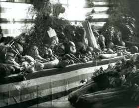
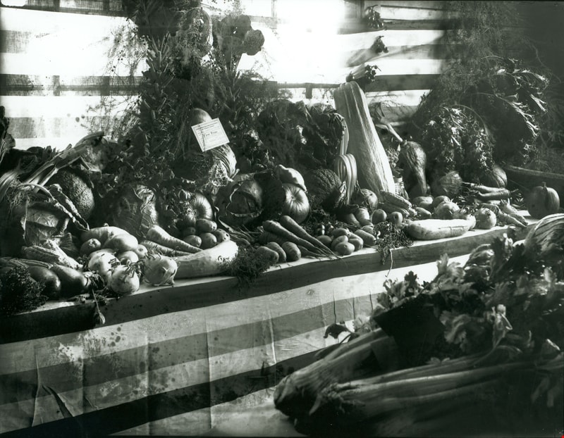
First Prize Vegetable display
https://search.heritageburnaby.ca/link/museumdescription3090
- Repository
- Burnaby Village Museum
- Date
- September 1914
- Collection/Fonds
- Burnaby Village Museum Photograph collection
- Description Level
- Item
- Physical Description
- 1 photograph : b&w glass negative ; 16 x 20.9 cm
- Scope and Content
- Photograph of a vegetable display at the 14th Annual Exhibition of the Central Park Agricultural Association and Farmers' Institute that took place from the 17th to 19th of September, 1914. The display "Surprise Poultry Yards Collection of Vegetables" features the First Prize card on its display.
- Repository
- Burnaby Village Museum
- Collection/Fonds
- Burnaby Village Museum Photograph collection
- Description Level
- Item
- Physical Description
- 1 photograph : b&w glass negative ; 16 x 20.9 cm
- Scope and Content
- Photograph of a vegetable display at the 14th Annual Exhibition of the Central Park Agricultural Association and Farmers' Institute that took place from the 17th to 19th of September, 1914. The display "Surprise Poultry Yards Collection of Vegetables" features the First Prize card on its display.
- Geographic Access
- Central Park
- Imperial Street
- Street Address
- 3883 Imperial Street
- Accession Code
- HV972.11.3
- Access Restriction
- No restrictions
- Reproduction Restriction
- No known restrictions
- Date
- September 1914
- Media Type
- Photograph
- Historic Neighbourhood
- Central Park (Historic Neighbourhood)
- Planning Study Area
- Maywood Area
- Related Material
- For another photograph of a vegetable display at the agricultural exhibition, see HV972.11.17. For a photograph of flower displays at the exhibition, see HV972.11.20
- Scan Resolution
- 300
- Scan Date
- 14/8/2006
- Scale
- 100
- Notes
- Title based on contents of photograph
- 1 b&w contact print accompanying negative
Images

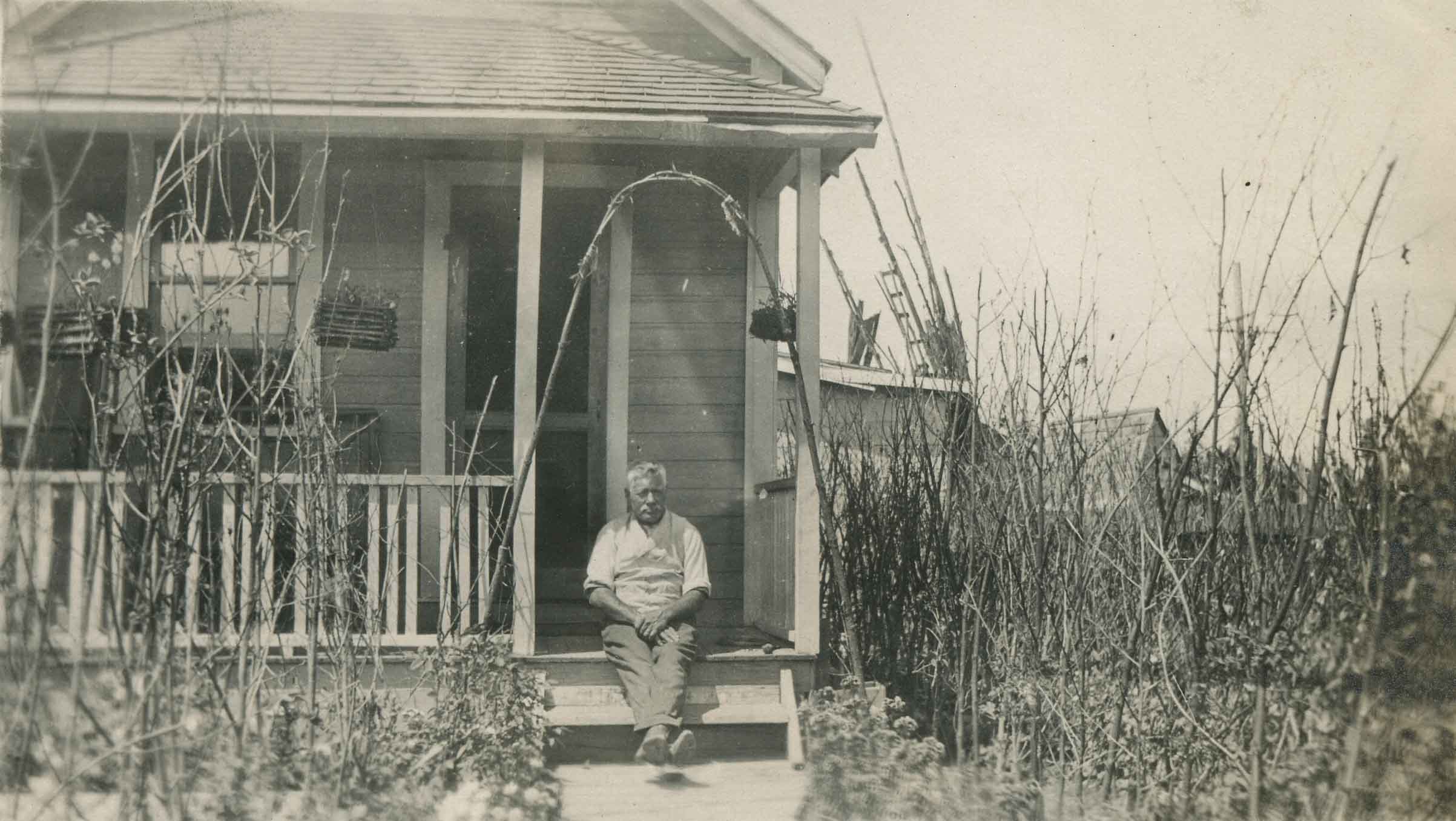
Frank Pitman house
https://search.heritageburnaby.ca/link/archivedescription35062
- Repository
- City of Burnaby Archives
- Date
- July 1, 1916
- Collection/Fonds
- Burnaby Historical Society fonds
- Description Level
- Item
- Physical Description
- 1 photograph : b&w ; 6.5 x 10.7 cm
- Scope and Content
- Photograph of Frank Pitman's house on Cassie Avenue. An annotation on the back of the photograph reads, "Cassie Ave July 1st 1916 / Home of Mr. Frank Pitman, father of Mr. Ernest Pitman." A man is seated on the front steps of the house.
- Repository
- City of Burnaby Archives
- Date
- July 1, 1916
- Collection/Fonds
- Burnaby Historical Society fonds
- Subseries
- Pitman family subseries
- Physical Description
- 1 photograph : b&w ; 6.5 x 10.7 cm
- Description Level
- Item
- Record No.
- 186-006
- Access Restriction
- No restrictions
- Reproduction Restriction
- No known restrictions
- Accession Number
- BHS1986-35
- Scope and Content
- Photograph of Frank Pitman's house on Cassie Avenue. An annotation on the back of the photograph reads, "Cassie Ave July 1st 1916 / Home of Mr. Frank Pitman, father of Mr. Ernest Pitman." A man is seated on the front steps of the house.
- Subjects
- Buildings - Residential - Houses
- Media Type
- Photograph
- Notes
- Title based on contents of photograph
- Geographic Access
- Cassie Avenue
- Historic Neighbourhood
- Central Park (Historic Neighbourhood)
- Planning Study Area
- Maywood Area
Images
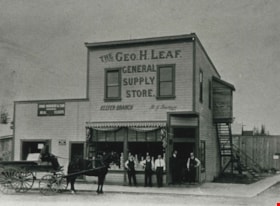
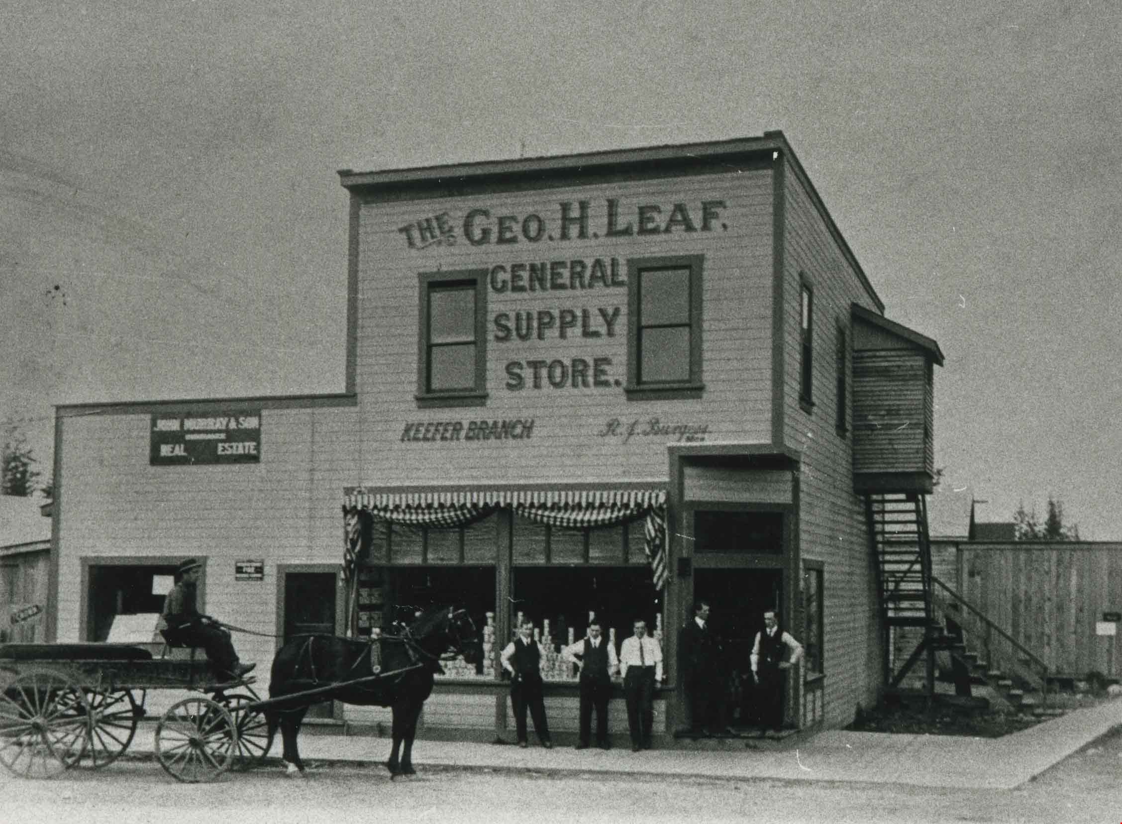
George Leaf General Store
https://search.heritageburnaby.ca/link/archivedescription35362
- Repository
- City of Burnaby Archives
- Date
- 1913 (date of original), copied 1986
- Collection/Fonds
- Burnaby Historical Society fonds
- Description Level
- Item
- Physical Description
- 1 photograph : b&w ; 12.7 x 17.8 cm print
- Scope and Content
- Photograph of the second George Leaf General Store, located on Keefer Road (now McKay Avenue). Bob Burgess (half-brother to George Leaf) was the manager of the store. George Leaf's first general store, located at 12th Avenue and 6th Street, 7745 6th Street, burned down in 1913.
- Repository
- City of Burnaby Archives
- Date
- 1913 (date of original), copied 1986
- Collection/Fonds
- Burnaby Historical Society fonds
- Subseries
- Pioneer Tales subseries
- Physical Description
- 1 photograph : b&w ; 12.7 x 17.8 cm print
- Description Level
- Item
- Record No.
- 204-219
- Access Restriction
- No restrictions
- Reproduction Restriction
- No known restrictions
- Accession Number
- BHS1988-03
- Scope and Content
- Photograph of the second George Leaf General Store, located on Keefer Road (now McKay Avenue). Bob Burgess (half-brother to George Leaf) was the manager of the store. George Leaf's first general store, located at 12th Avenue and 6th Street, 7745 6th Street, burned down in 1913.
- Media Type
- Photograph
- Notes
- Title based on contents of photograph
- Geographic Access
- McKay Avenue
- Historic Neighbourhood
- Central Park (Historic Neighbourhood)
- Planning Study Area
- Maywood Area
Images

Gillmore Poultry Farm
https://search.heritageburnaby.ca/link/archivedescription35388
- Repository
- City of Burnaby Archives
- Date
- 1911 (date of original), copied 1986
- Collection/Fonds
- Burnaby Historical Society fonds
- Description Level
- Item
- Physical Description
- 1 photograph : b&w ; 12.7 x 17.8 cm print
- Scope and Content
- Photograph of (left to right) Jack Gillmore and his mother, Jean Gillmore, feeding some of the 2,000 chickens on Red Feather Poultry Ranch on Keefer Road (later becoming 6350 McKay Avenue). The ranch was founded by Charles Reginald Gillmore. Charles R. Gillmore was married to Jean Leslie Mills an…
- Repository
- City of Burnaby Archives
- Date
- 1911 (date of original), copied 1986
- Collection/Fonds
- Burnaby Historical Society fonds
- Subseries
- Pioneer Tales subseries
- Physical Description
- 1 photograph : b&w ; 12.7 x 17.8 cm print
- Description Level
- Item
- Record No.
- 204-245
- Access Restriction
- No restrictions
- Reproduction Restriction
- No known restrictions
- Accession Number
- BHS1988-03
- Scope and Content
- Photograph of (left to right) Jack Gillmore and his mother, Jean Gillmore, feeding some of the 2,000 chickens on Red Feather Poultry Ranch on Keefer Road (later becoming 6350 McKay Avenue). The ranch was founded by Charles Reginald Gillmore. Charles R. Gillmore was married to Jean Leslie Mills and was a principal in Gillmore, Mills & Co. of 170 Water Street in Vancouver.
- Subjects
- Animals - Poultry
- Agriculture - Farms
- Media Type
- Photograph
- Notes
- Title based on contents of photograph
- Geographic Access
- McKay Avenue
- Street Address
- 6350 McKay Avenue
- Historic Neighbourhood
- Central Park (Historic Neighbourhood)
- Planning Study Area
- Maywood Area
Images


Gillmore Poultry Farm
https://search.heritageburnaby.ca/link/archivedescription35389
- Repository
- City of Burnaby Archives
- Date
- 1911 (date of original), copied 1986
- Collection/Fonds
- Burnaby Historical Society fonds
- Description Level
- Item
- Physical Description
- 1 photograph : b&w ; 12.7 x 17.8 cm print
- Scope and Content
- Photograph of ducks on the Red Feather Poultry Ranch located on Keefer Road (later becoming 6350 McKay Avenue). The long ranch house is faintly discernable in the background. The farm was operated by Charles R. Gillmore.
- Repository
- City of Burnaby Archives
- Date
- 1911 (date of original), copied 1986
- Collection/Fonds
- Burnaby Historical Society fonds
- Subseries
- Pioneer Tales subseries
- Physical Description
- 1 photograph : b&w ; 12.7 x 17.8 cm print
- Description Level
- Item
- Record No.
- 204-246
- Access Restriction
- No restrictions
- Reproduction Restriction
- No known restrictions
- Accession Number
- BHS1988-03
- Scope and Content
- Photograph of ducks on the Red Feather Poultry Ranch located on Keefer Road (later becoming 6350 McKay Avenue). The long ranch house is faintly discernable in the background. The farm was operated by Charles R. Gillmore.
- Subjects
- Animals - Poultry
- Agriculture - Farms
- Media Type
- Photograph
- Notes
- Title based on contents of photograph
- Geographic Access
- McKay Avenue
- Street Address
- 6350 McKay Avenue
- Historic Neighbourhood
- Central Park (Historic Neighbourhood)
- Planning Study Area
- Maywood Area
Images

![Girl Guides in Central Park, [1917] thumbnail](/media/hpo/_Data/_Archives_Images/_Unrestricted/251/292-002.jpg?width=280)
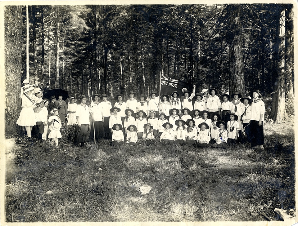
Girl Guides in Central Park
https://search.heritageburnaby.ca/link/archivedescription36539
- Repository
- City of Burnaby Archives
- Date
- [1917]
- Collection/Fonds
- Burnaby Historical Society fonds
- Description Level
- Item
- Physical Description
- 1 photograph : b&w ; 8.5 x 14 cm + 1 p.
- Scope and Content
- Photograph of the Burnaby Girl Guides in Central Park seated and standing in rows. This was the first year of this group of Girl Guides. Gwen Pitman is in the front row, third from the right. In the second row, are; Grace Strong, McKenzie, and Ivy Brett sitting third, fourth, and fifth from the lef…
- Repository
- City of Burnaby Archives
- Date
- [1917]
- Collection/Fonds
- Burnaby Historical Society fonds
- Subseries
- Pitman family subseries
- Physical Description
- 1 photograph : b&w ; 8.5 x 14 cm + 1 p.
- Description Level
- Item
- Record No.
- 292-002
- Access Restriction
- No restrictions
- Reproduction Restriction
- No known restrictions
- Accession Number
- BHS1992-29
- Scope and Content
- Photograph of the Burnaby Girl Guides in Central Park seated and standing in rows. This was the first year of this group of Girl Guides. Gwen Pitman is in the front row, third from the right. In the second row, are; Grace Strong, McKenzie, and Ivy Brett sitting third, fourth, and fifth from the left. Amy Leigh was the leader of the troop.
- Media Type
- Photograph
- Notes
- Title based on contents of photograph
- Page accompanying identifies four members of the group, and lists: "...other names in this group: M.Thompson/ Pullinger/ Mrs. Greenwood (Miss?)/ Elsie Warden & Edmonds Group/ Elise Russell/ Rose Adams/ Ruth Dean/ Ethel Lewis, or Clark./ Munday/ Ruby Ayles/ Nessie Abbey/ Joy Mennie/ Margie Dingman/ Abbie Nelson/ A.D.Ladner/ Pauline Capelle"
- Geographic Access
- Central Park
- Imperial Street
- Street Address
- 3883 Imperial Street
- Historic Neighbourhood
- Central Park (Historic Neighbourhood)
- Planning Study Area
- Maywood Area
Images
![Girl Guides in Central Park, [1917] thumbnail](/media/hpo/_Data/_Archives_Images/_Unrestricted/251/292-002.jpg)
![Gordon Presbyterian Church Refreshment Building, [1918] (date of original), copied 1987 thumbnail](/media/hpo/_Data/_Archives_Images/_Unrestricted/126/193-003.jpg?width=280)
Gordon Presbyterian Church Refreshment Building
https://search.heritageburnaby.ca/link/archivedescription35102
- Repository
- City of Burnaby Archives
- Date
- [1918] (date of original), copied 1987
- Collection/Fonds
- Burnaby Historical Society fonds
- Description Level
- Item
- Physical Description
- 1 photograph : b&w ; 8.8 x 12.5 cm print
- Scope and Content
- Photograph of the exterior of the Gordon Presbyterian Church refreshment building at the Central Park Agricultural Exhibition. Signs on the building read, "Gordon Presby Church," "Continuous Performance," "This is the Best," "Home Cooking / [illegible] just like Mother's / [Smells?] Good! Tastes B…
- Repository
- City of Burnaby Archives
- Date
- [1918] (date of original), copied 1987
- Collection/Fonds
- Burnaby Historical Society fonds
- Subseries
- Gordon Presbyterian Church subseries
- Physical Description
- 1 photograph : b&w ; 8.8 x 12.5 cm print
- Description Level
- Item
- Record No.
- 193-003
- Access Restriction
- No restrictions
- Reproduction Restriction
- No known restrictions
- Accession Number
- BHS1987-02
- Scope and Content
- Photograph of the exterior of the Gordon Presbyterian Church refreshment building at the Central Park Agricultural Exhibition. Signs on the building read, "Gordon Presby Church," "Continuous Performance," "This is the Best," "Home Cooking / [illegible] just like Mother's / [Smells?] Good! Tastes Better!," "Place to Dine," and "Hot Meals." Three women and a boy are outside the building.
- Subjects
- Exhibitions - Agricultural
- Buildings - Commercial - Restaurants
- Advertising Medium - Signs and Signboards
- Media Type
- Photograph
- Notes
- Title based on contents of photograph
- Geographic Access
- Central Park
- Imperial Street
- Street Address
- 3883 Imperial Street
- Historic Neighbourhood
- Central Park (Historic Neighbourhood)
- Planning Study Area
- Maywood Area
Images
![Gordon Presbyterian Church Refreshment Building, [1918] (date of original), copied 1987 thumbnail](/media/hpo/_Data/_Archives_Images/_Unrestricted/126/193-003.jpg)
![Gordon Presbyterian Church Refreshment Tent, [1912] (date of original), copied 1987 thumbnail](/media/hpo/_Data/_Archives_Images/_Unrestricted/126/193-001.jpg?width=280)
Gordon Presbyterian Church Refreshment Tent
https://search.heritageburnaby.ca/link/archivedescription35100
- Repository
- City of Burnaby Archives
- Date
- [1912] (date of original), copied 1987
- Collection/Fonds
- Burnaby Historical Society fonds
- Description Level
- Item
- Physical Description
- 1 photograph : b&w ; 8.8 x 12.5 cm print
- Scope and Content
- Photograph of the exterior of the Gordon Presbyterian Church refreshment tent at the Central Park Agricultural Exhibition. Banners above the door of the tent read, "Gordon Presby Church Refreshments" and "Hot Meals." Other banners and penants read, "God Save the King" and "Canada." Nine women an…
- Repository
- City of Burnaby Archives
- Date
- [1912] (date of original), copied 1987
- Collection/Fonds
- Burnaby Historical Society fonds
- Subseries
- Gordon Presbyterian Church subseries
- Physical Description
- 1 photograph : b&w ; 8.8 x 12.5 cm print
- Description Level
- Item
- Record No.
- 193-001
- Access Restriction
- No restrictions
- Reproduction Restriction
- No known restrictions
- Accession Number
- BHS1987-02
- Scope and Content
- Photograph of the exterior of the Gordon Presbyterian Church refreshment tent at the Central Park Agricultural Exhibition. Banners above the door of the tent read, "Gordon Presby Church Refreshments" and "Hot Meals." Other banners and penants read, "God Save the King" and "Canada." Nine women and two men are standing outside the tent. The women are wearing aprons. There is an automobile parked on the right side of the photograph.
- Subjects
- Buildings - Commercial - Restaurants
- Advertising Medium - Signs and Signboards
- Structures - Tents
- Media Type
- Photograph
- Notes
- Title based on contents of photograph
- Geographic Access
- Central Park
- Imperial Street
- Street Address
- 3883 Imperial Street
- Historic Neighbourhood
- Central Park (Historic Neighbourhood)
- Planning Study Area
- Maywood Area
Images
![Gordon Presbyterian Church Refreshment Tent, [1912] (date of original), copied 1987 thumbnail](/media/hpo/_Data/_Archives_Images/_Unrestricted/126/193-001.jpg)
![Gordon Presbyterian Church Refreshment Tent, [1912] (date of original), copied 1987 thumbnail](/media/hpo/_Data/_Archives_Images/_Unrestricted/126/193-002.jpg?width=280)
Gordon Presbyterian Church Refreshment Tent
https://search.heritageburnaby.ca/link/archivedescription35101
- Repository
- City of Burnaby Archives
- Date
- [1912] (date of original), copied 1987
- Collection/Fonds
- Burnaby Historical Society fonds
- Description Level
- Item
- Physical Description
- 1 photograph : b&w ; 8.7 x 12.4 cm print
- Scope and Content
- Photograph of the exterior of the Gordon Presbyterian Church refreshment tent at the Central Park Agricultural Exhibition. A sign above the door of the tent reads, "Gordon Presby Church Refreshments." Eight women and two men are standing outside the tent. The women are wearing aprons. Pennants …
- Repository
- City of Burnaby Archives
- Date
- [1912] (date of original), copied 1987
- Collection/Fonds
- Burnaby Historical Society fonds
- Subseries
- Gordon Presbyterian Church subseries
- Physical Description
- 1 photograph : b&w ; 8.7 x 12.4 cm print
- Description Level
- Item
- Record No.
- 193-002
- Access Restriction
- No restrictions
- Reproduction Restriction
- No known restrictions
- Accession Number
- BHS1987-02
- Scope and Content
- Photograph of the exterior of the Gordon Presbyterian Church refreshment tent at the Central Park Agricultural Exhibition. A sign above the door of the tent reads, "Gordon Presby Church Refreshments." Eight women and two men are standing outside the tent. The women are wearing aprons. Pennants on the tent read, "Canada."
- Subjects
- Buildings - Commercial - Restaurants
- Advertising Medium - Signs and Signboards
- Structures - Tents
- Media Type
- Photograph
- Notes
- Title based on contents of photograph
- Geographic Access
- Central Park
- Imperial Street
- Street Address
- 3883 Imperial Street
- Historic Neighbourhood
- Central Park (Historic Neighbourhood)
- Planning Study Area
- Maywood Area
Images
![Gordon Presbyterian Church Refreshment Tent, [1912] (date of original), copied 1987 thumbnail](/media/hpo/_Data/_Archives_Images/_Unrestricted/126/193-002.jpg)
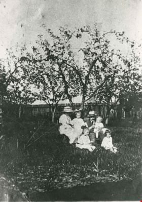
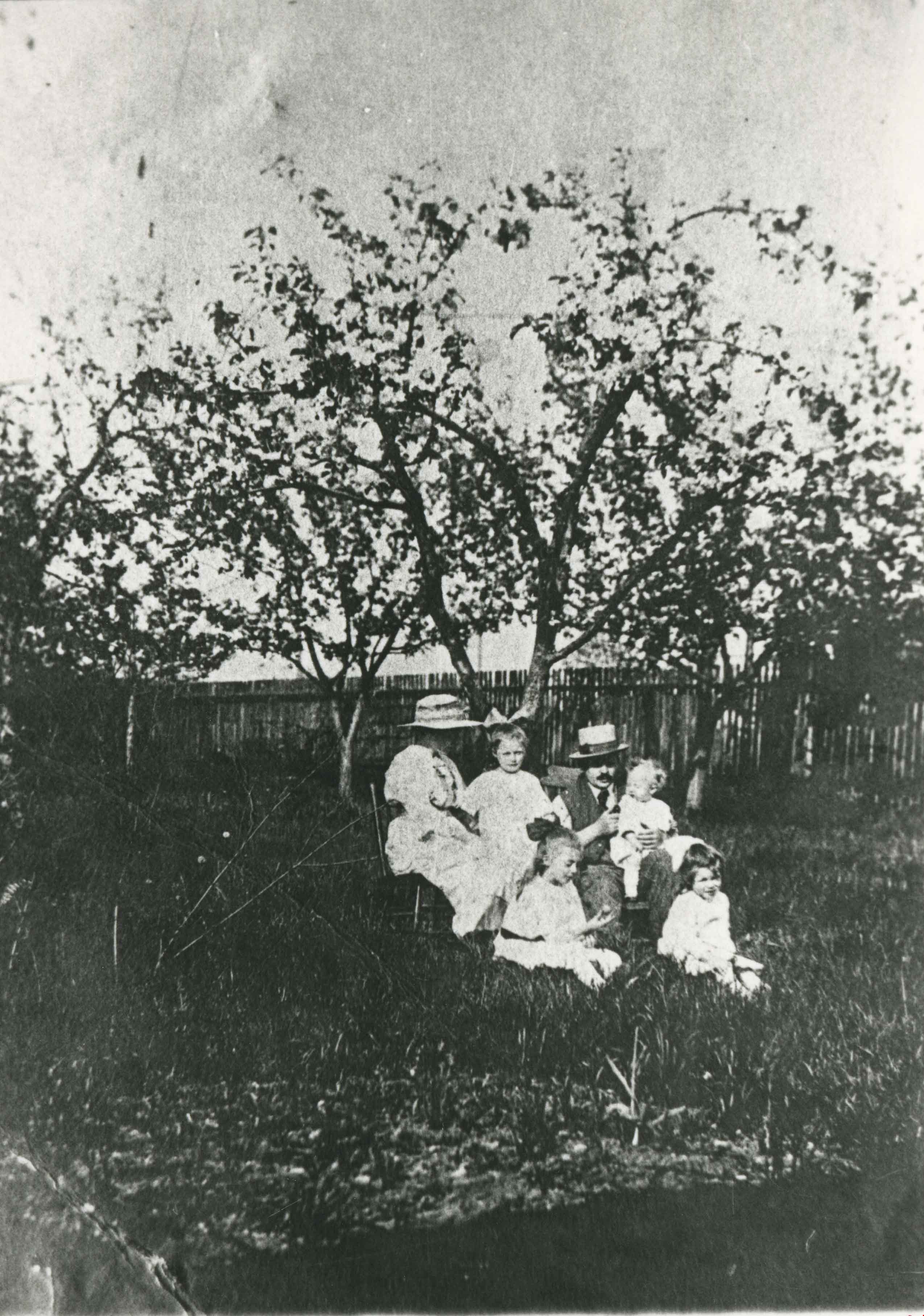
Holmes family
https://search.heritageburnaby.ca/link/archivedescription35751
- Repository
- City of Burnaby Archives
- Date
- 1916 (date of original), copied 1986
- Collection/Fonds
- Burnaby Historical Society fonds
- Description Level
- Item
- Physical Description
- 1 photograph : b&w ; 12.7 x 17.8 cm print
- Scope and Content
- Photograph of the Holmes family in the orchard of their rented home at Kingsway and Kathleen Avenue. Parents (left to right) Johnson "Jerry" Holmes (father) and Mrs. Cissie Holmes (mother). Children (left to right) Kathleen Holmes (sister), Eileen Holmes (sister), Mary Holmes (sister), and Harry …
- Repository
- City of Burnaby Archives
- Date
- 1916 (date of original), copied 1986
- Collection/Fonds
- Burnaby Historical Society fonds
- Subseries
- Pioneer Tales subseries
- Physical Description
- 1 photograph : b&w ; 12.7 x 17.8 cm print
- Description Level
- Item
- Record No.
- 204-609
- Access Restriction
- No restrictions
- Reproduction Restriction
- No known restrictions
- Accession Number
- BHS1988-03
- Scope and Content
- Photograph of the Holmes family in the orchard of their rented home at Kingsway and Kathleen Avenue. Parents (left to right) Johnson "Jerry" Holmes (father) and Mrs. Cissie Holmes (mother). Children (left to right) Kathleen Holmes (sister), Eileen Holmes (sister), Mary Holmes (sister), and Harry Holmes (brother).
- Subjects
- Agriculture - Orchards
- Names
- Baker, Kathleen Holmes
- Holmes, Alice Mary Harbottle "Cissie"
- Holmes, Eileen
- Holmes, Johnson "Jerry"
- Holmes, Mary
- Media Type
- Photograph
- Notes
- Title based on contents of photograph
- Geographic Access
- Kingsway
- Kathleen Avenue
- Historic Neighbourhood
- Central Park (Historic Neighbourhood)
- Planning Study Area
- Maywood Area
Images

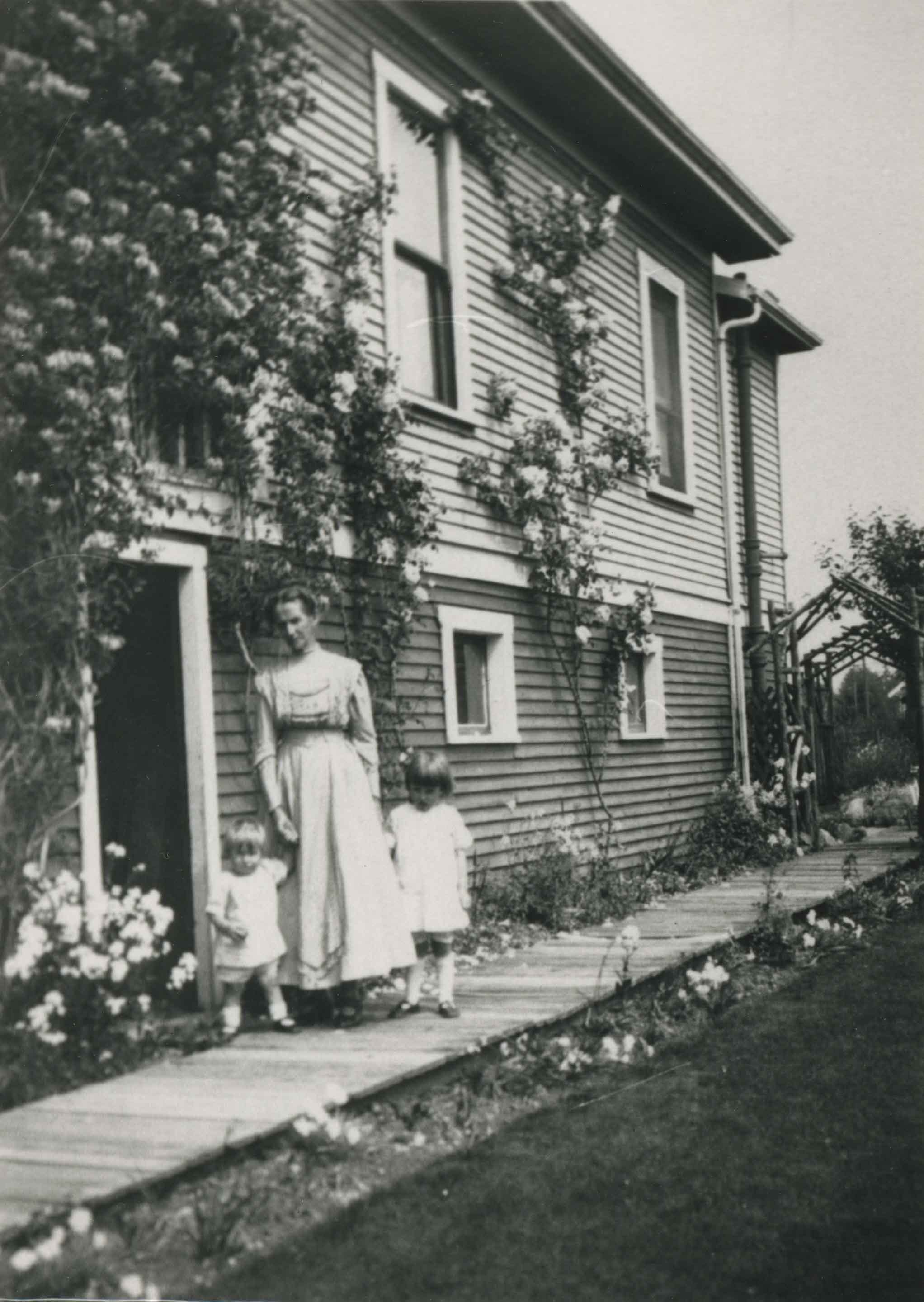
Hopper family
https://search.heritageburnaby.ca/link/archivedescription35081
- Repository
- City of Burnaby Archives
- Date
- 1912 (date of original), copied 1986
- Collection/Fonds
- Burnaby Historical Society fonds
- Description Level
- Item
- Physical Description
- 1 photograph : b&w ; 12.5 x 8.8 cm print
- Scope and Content
- Photograph of Mrs. Hopper and her grandchildren, Betty and Lois Atkinson, in the sideyard of a house on Kathleen Avenue. They are standing on a board sidewalk, and the flowers surrounding the house are in bloom.
- Repository
- City of Burnaby Archives
- Date
- 1912 (date of original), copied 1986
- Collection/Fonds
- Burnaby Historical Society fonds
- Subseries
- Davies family subseries
- Physical Description
- 1 photograph : b&w ; 12.5 x 8.8 cm print
- Description Level
- Item
- Record No.
- 190-001
- Access Restriction
- No restrictions
- Reproduction Restriction
- No known restrictions
- Accession Number
- BHS1986-41
- Scope and Content
- Photograph of Mrs. Hopper and her grandchildren, Betty and Lois Atkinson, in the sideyard of a house on Kathleen Avenue. They are standing on a board sidewalk, and the flowers surrounding the house are in bloom.
- Media Type
- Photograph
- Notes
- Title based on contents of photograph
- Geographic Access
- Kathleen Avenue
- Historic Neighbourhood
- Central Park (Historic Neighbourhood)
- Planning Study Area
- Maywood Area
Images

Inauguration of the water system at Burnaby
https://search.heritageburnaby.ca/link/archivedescription35938
- Repository
- City of Burnaby Archives
- Date
- July 16, 1912
- Collection/Fonds
- Burnaby Historical Society fonds
- Description Level
- Item
- Physical Description
- 1 photograph : b&w postcard ; 8.9 x 14.0 cm
- Scope and Content
- Photographic postcard of Reeve Weart addressing a crowd gathered around the bandstand in Central Park for the inauguration of Burnaby Water Works. The Reeve is standing as he looks towards the crowd. Other men are seated in a semi-circle inside the bandstand. This was known as "Splash Day."
- Repository
- City of Burnaby Archives
- Date
- July 16, 1912
- Collection/Fonds
- Burnaby Historical Society fonds
- Subseries
- Pioneer Tales subseries
- Physical Description
- 1 photograph : b&w postcard ; 8.9 x 14.0 cm
- Description Level
- Item
- Record No.
- 204-798
- Access Restriction
- No restrictions
- Reproduction Restriction
- No known restrictions
- Accession Number
- BHS1988-03
- Scope and Content
- Photographic postcard of Reeve Weart addressing a crowd gathered around the bandstand in Central Park for the inauguration of Burnaby Water Works. The Reeve is standing as he looks towards the crowd. Other men are seated in a semi-circle inside the bandstand. This was known as "Splash Day."
- Subjects
- Buildings - Recreational - Bandstands
- Persons - Crowds
- Officials - Mayors and Reeves
- Public Services - Utilities
- Public Services - Public Works
- Documentary Artifacts - Postcards
- Names
- Weart, R.W.
- Media Type
- Photograph
- Notes
- 1 b&w copy negative accompanying
- Annotation of back of postcard reads, "July 16 - 1912 / Inauguration of the water system at Burnaby"
- Geographic Access
- Central Park
- Imperial Street
- Street Address
- 3883 Imperial Street
- Historic Neighbourhood
- Central Park (Historic Neighbourhood)
- Planning Study Area
- Maywood Area
Images


Jack Gillmore
https://search.heritageburnaby.ca/link/archivedescription35392
- Repository
- City of Burnaby Archives
- Date
- 1910 (date of original), copied 1986
- Collection/Fonds
- Burnaby Historical Society fonds
- Description Level
- Item
- Physical Description
- 1 photograph : b&w ; 12.7 x 17.8 cm print
- Scope and Content
- Photograph of Jack Gillmore holding a bantam. The long ranch home and chicken pens can be seen. Jack was the son of Charles R. Gillmore who operated the Red Feather Poultry Ranch on Keefer Road (later becoming 6350 McKay Avenue).
- Repository
- City of Burnaby Archives
- Date
- 1910 (date of original), copied 1986
- Collection/Fonds
- Burnaby Historical Society fonds
- Subseries
- Pioneer Tales subseries
- Physical Description
- 1 photograph : b&w ; 12.7 x 17.8 cm print
- Description Level
- Item
- Record No.
- 204-249
- Access Restriction
- No restrictions
- Reproduction Restriction
- No known restrictions
- Accession Number
- BHS1988-03
- Scope and Content
- Photograph of Jack Gillmore holding a bantam. The long ranch home and chicken pens can be seen. Jack was the son of Charles R. Gillmore who operated the Red Feather Poultry Ranch on Keefer Road (later becoming 6350 McKay Avenue).
- Subjects
- Animals - Poultry
- Agriculture - Farms
- Media Type
- Photograph
- Notes
- Title based on contents of photograph
- Geographic Access
- McKay Avenue
- Street Address
- 6350 McKay Avenue
- Historic Neighbourhood
- Central Park (Historic Neighbourhood)
- Planning Study Area
- Maywood Area
Images

![Kingsway, [1914] thumbnail](/media/hpo/_Data/_BVM_Images/1971/197200110008.jpg?width=280)
Kingsway
https://search.heritageburnaby.ca/link/museumdescription3094
- Repository
- Burnaby Village Museum
- Date
- [1914]
- Collection/Fonds
- Burnaby Village Museum Photograph collection
- Description Level
- Item
- Physical Description
- 1 photograph : b&w glass negative ; 15.8 x 21.1 cm
- Scope and Content
- Photograph of a paved road lined with electric posts, a sidewalk and fences. There are two unidentified men in suits and bowler hats standing on one side of the road, each by a different electric post. A car is driving towards the horizon. An earlier catalogue record from 1988 notes that the view …
- Repository
- Burnaby Village Museum
- Collection/Fonds
- Burnaby Village Museum Photograph collection
- Description Level
- Item
- Physical Description
- 1 photograph : b&w glass negative ; 15.8 x 21.1 cm
- Scope and Content
- Photograph of a paved road lined with electric posts, a sidewalk and fences. There are two unidentified men in suits and bowler hats standing on one side of the road, each by a different electric post. A car is driving towards the horizon. An earlier catalogue record from 1988 notes that the view is of Kingsway looking east from Willingdon Avenue towards the community of McKay and Kingsway. It also notes that the McKay Block is visible on the far right side of the photograph at McKay Avenue and Kingsway. The record dates the negative ca. 1914.
- Subjects
- Geographic Features - Roads
- Geographic Access
- Kingsway
- Willingdon Avenue
- Accession Code
- HV972.11.8
- Access Restriction
- No restrictions
- Reproduction Restriction
- No known restrictions
- Date
- [1914]
- Media Type
- Photograph
- Historic Neighbourhood
- Central Park (Historic Neighbourhood)
- Planning Study Area
- Maywood Area
- Scan Resolution
- 300
- Scan Date
- 14/8/2006
- Scale
- 100
- Notes
- Title based on contents of photograph
- 1 b&w contact print accompanying negative
Images
![Kingsway, [1914] thumbnail](/media/hpo/_Data/_BVM_Images/1971/197200110008.jpg)
![Kingsway West School, Burnaby, BC, 1917 (date of original), copied [1972] thumbnail](/media/hpo/_Data/_BVM_Images/1972/1972_0120_0001_001.jpg?width=280)
Kingsway West School, Burnaby, BC
https://search.heritageburnaby.ca/link/museumdescription1093
- Repository
- Burnaby Village Museum
- Date
- 1917 (date of original), copied [1972]
- Collection/Fonds
- Burnaby Village Museum Photograph collection
- Description Level
- Item
- Physical Description
- 1 photograph : b&w ; 25.4 x 20.3 cm print
- Scope and Content
- Photograph of the Grade 7 class at Kingsway West (originally named West Burnaby) School. Edith Crake is the teacher. The students are standing on the steps of the school.There are 20 boys and 12 girls, and Ms. Crake. Accompanying notes partially identify the students. Front row: left to right. 1) …
- Repository
- Burnaby Village Museum
- Collection/Fonds
- Burnaby Village Museum Photograph collection
- Description Level
- Item
- Physical Description
- 1 photograph : b&w ; 25.4 x 20.3 cm print
- Scope and Content
- Photograph of the Grade 7 class at Kingsway West (originally named West Burnaby) School. Edith Crake is the teacher. The students are standing on the steps of the school.There are 20 boys and 12 girls, and Ms. Crake. Accompanying notes partially identify the students. Front row: left to right. 1) Abbey, 2)&3) [unidentified], 4) Gladys Coates, 5) Ina Hart, 6) [unidentified]. Second row: left to right. 7) [unidentified], 8) [first name unknown] Murrey, 9) [first name unknown] Chapple, 10) [first name unknown] Murrey, 11)&12) [unidentified]. Third row: left to right. 13) Edith Crake (teacher), 14) Stewart MacPherson, 15) Bert Price, 16) [unidentified], 17) Gilbert Summers, 18) Alden Tayler, 19) [unidentified]. Fourth row: 20) Harold Lomas, 21) Hugh Silver, 22) [first name unknown] Murrey [?], 23) [unidentified], 24) Murray Hilton. Fifth row: 25) [unidentified], 26) Bill Logan [?], 27) [unidentified], 28) George Main. An annotation at the bottom of the original photograph reads, "Kingsway West School, Burnaby, B.C."
- Subjects
- Occupations - Teachers
- Names
- Coates, Gladys
- Crake, Edith
- Hart, Ina
- Hilton, Murray
- Kingsway West School
- Logan, Bill
- Lomas, Harold
- MacPherson, Stewart
- Main, George
- Price, Bert
- Silver, Hugh
- Summers, Gilbert
- Tayler, Alden
- Geographic Access
- Kingsway
- Street Address
- 4800 Kingsway
- Accession Code
- HV972.120.1
- Access Restriction
- No restrictions
- Reproduction Restriction
- May be restricted by third party rights
- Date
- 1917 (date of original), copied [1972]
- Media Type
- Photograph
- Historic Neighbourhood
- Central Park (Historic Neighbourhood)
- Planning Study Area
- Maywood Area
- Scan Resolution
- 600
- Scan Date
- 2023-04-18
Images
![Kingsway West School, Burnaby, BC, 1917 (date of original), copied [1972] thumbnail](/media/hpo/_Data/_BVM_Images/1972/1972_0120_0001_001.jpg)

Kingsway West School site
https://search.heritageburnaby.ca/link/museumdescription11122
- Repository
- Burnaby Village Museum
- Date
- March 16, 1915
- Collection/Fonds
- Ronald G. Scobbie collection
- Description Level
- Item
- Physical Description
- 1 survey plan : blueprint on paper with pencil notations ; 56 x 54 cm
- Scope and Content
- Survey plan of "Kingsway West School Site" "Burnaby Municipality" "being Lot 1, D.L.32, Lot 1 of Lot 21, Portion of Lot 21 and Portion of Lot 20, of subdivision of D.L.152, 153 & Portion of Lot 151, Group 1, New Westminster District". Notations in pencil extend along the south boundary line of Dist…
- Repository
- Burnaby Village Museum
- Collection/Fonds
- Ronald G. Scobbie collection
- Description Level
- Item
- Physical Description
- 1 survey plan : blueprint on paper with pencil notations ; 56 x 54 cm
- Material Details
- Scale: 40 feet = 1 inch
- Scope and Content
- Survey plan of "Kingsway West School Site" "Burnaby Municipality" "being Lot 1, D.L.32, Lot 1 of Lot 21, Portion of Lot 21 and Portion of Lot 20, of subdivision of D.L.152, 153 & Portion of Lot 151, Group 1, New Westminster District". Notations in pencil extend along the south boundary line of District Lot 32.
- Creator
- McGugan, Donald Johnston
- Subjects
- Buildings - Schools
- Names
- Kingsway West School
- Responsibility
- Burnett and McGugan B.C. Land Surveyors, New Westminster
- Geographic Access
- Kingsway
- Sussex Avenue
- Accession Code
- BV003.83.2
- Access Restriction
- No restrictions
- Reproduction Restriction
- No known restrictions
- Date
- March 16, 1915
- Media Type
- Cartographic Material
- Historic Neighbourhood
- Central Park (Historic Neighbourhood)
- Planning Study Area
- Maywood Area
- Scan Resolution
- 440
- Scan Date
- 22-Dec-2020
- Scale
- 100
- Notes
- Transcribed title
- Oath in bottom left corner reads: "I, D.J. McGugan...did personally superintend the survey ..." "...completed on the 16th day of March 1915", signed "D.J. McGugan" and is notarized on March 19th, 1915 by "S.F. Frank" with a seal
- handwritten on back, "1753";
- See also BV003.83.9 - duplicate blueprint plan without annotations
- See also BV003.83.3 for original plan on waxed linen
Zoomable Images

Kingsway West School site
https://search.heritageburnaby.ca/link/museumdescription11123
- Repository
- Burnaby Village Museum
- Date
- March 16, 1915
- Collection/Fonds
- Ronald G. Scobbie collection
- Description Level
- Item
- Physical Description
- 1 survey plan : blackline print on waxed linen ; 59 x 59 cm
- Scope and Content
- Survey plan titled “Kingsway West School Site" "Burnaby Municipality" / being Lot 1, D.L.32, Lot 1 of Lot 21, Portion of / Lot 21 and Portion of Lot 20, of subdivision / of D.L.152, 153 & Portion of Lot 151, Group 1 / New Westminster District".
- Repository
- Burnaby Village Museum
- Collection/Fonds
- Ronald G. Scobbie collection
- Description Level
- Item
- Physical Description
- 1 survey plan : blackline print on waxed linen ; 59 x 59 cm
- Material Details
- Scale [1:480]
- Scope and Content
- Survey plan titled “Kingsway West School Site" "Burnaby Municipality" / being Lot 1, D.L.32, Lot 1 of Lot 21, Portion of / Lot 21 and Portion of Lot 20, of subdivision / of D.L.152, 153 & Portion of Lot 151, Group 1 / New Westminster District".
- Subjects
- Buildings - Schools
- Names
- Kingsway West School
- Geographic Access
- Kingsway
- Sussex Avenue
- Accession Code
- BV003.83.3
- Access Restriction
- No restrictions
- Reproduction Restriction
- No known restrictions
- Date
- March 16, 1915
- Media Type
- Cartographic Material
- Historic Neighbourhood
- Central Park (Historic Neighbourhood)
- Planning Study Area
- Maywood Area
- Notes
- Transcribed title
- Scale on plan reads" 40 feet = 1 inch"
- Oath on plan reads: "I, D.J. McGugan...did personally superintend the survey ..." "...completed on the 16th day of March 1915", signed "D.J. McGugan", and notarized by "S.F. Mark
- See also BV0003.83.2 for digitized blueprint