
Cassie Avenue
https://search.heritageburnaby.ca/link/archivedescription35064
- Repository
- City of Burnaby Archives
- Date
- November 7, 1915
- Collection/Fonds
- Burnaby Historical Society fonds
- Description Level
- Item
- Physical Description
- 1 photograph : b&w ; 6.0 x 10.0 cm
- Scope and Content
- Photograph of Cassie Avenue, south of the railroad tracks, in the snow. Buildings and piles of lumber can be seen. An annotation on the back of the photograph reads, "Cassie Ave - South of tracks / Nov 7th 1915."
- Repository
- City of Burnaby Archives
- Date
- November 7, 1915
- Collection/Fonds
- Burnaby Historical Society fonds
- Subseries
- Pitman family subseries
- Physical Description
- 1 photograph : b&w ; 6.0 x 10.0 cm
- Description Level
- Item
- Record No.
- 186-008
- Access Restriction
- No restrictions
- Reproduction Restriction
- No known restrictions
- Accession Number
- BHS1986-35
- Scope and Content
- Photograph of Cassie Avenue, south of the railroad tracks, in the snow. Buildings and piles of lumber can be seen. An annotation on the back of the photograph reads, "Cassie Ave - South of tracks / Nov 7th 1915."
- Subjects
- Geographic Features - Roads
- Media Type
- Photograph
- Geographic Access
- Cassie Avenue
- Historic Neighbourhood
- Central Park (Historic Neighbourhood)
- Planning Study Area
- Maywood Area
Images

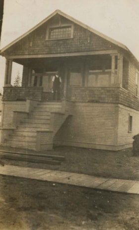
Ernest Pitman family home
https://search.heritageburnaby.ca/link/archivedescription35063
- Repository
- City of Burnaby Archives
- Date
- July 1913
- Collection/Fonds
- Burnaby Historical Society fonds
- Description Level
- Item
- Physical Description
- 1 photograph : b&w ; 10.2 x 6.3 cm
- Scope and Content
- Photograph of Mr and Mrs. Ernest Pitman's house on Cassie Avenue. A man is standing at the top of the porch stairs. Note the board sidewalk in front of the house. An annotation on the back of the photograph reads; "July 1913 / Cassie Ave / Home of Mr. & Mrs. Ernest Pitman."
- Repository
- City of Burnaby Archives
- Date
- July 1913
- Collection/Fonds
- Burnaby Historical Society fonds
- Subseries
- Pitman family subseries
- Physical Description
- 1 photograph : b&w ; 10.2 x 6.3 cm
- Description Level
- Item
- Record No.
- 186-007
- Access Restriction
- No restrictions
- Reproduction Restriction
- No known restrictions
- Accession Number
- BHS1986-35
- Scope and Content
- Photograph of Mr and Mrs. Ernest Pitman's house on Cassie Avenue. A man is standing at the top of the porch stairs. Note the board sidewalk in front of the house. An annotation on the back of the photograph reads; "July 1913 / Cassie Ave / Home of Mr. & Mrs. Ernest Pitman."
- Media Type
- Photograph
- Notes
- Title based on contents of photograph
- Geographic Access
- Cassie Avenue
- Historic Neighbourhood
- Central Park (Historic Neighbourhood)
- Planning Study Area
- Maywood Area
Images


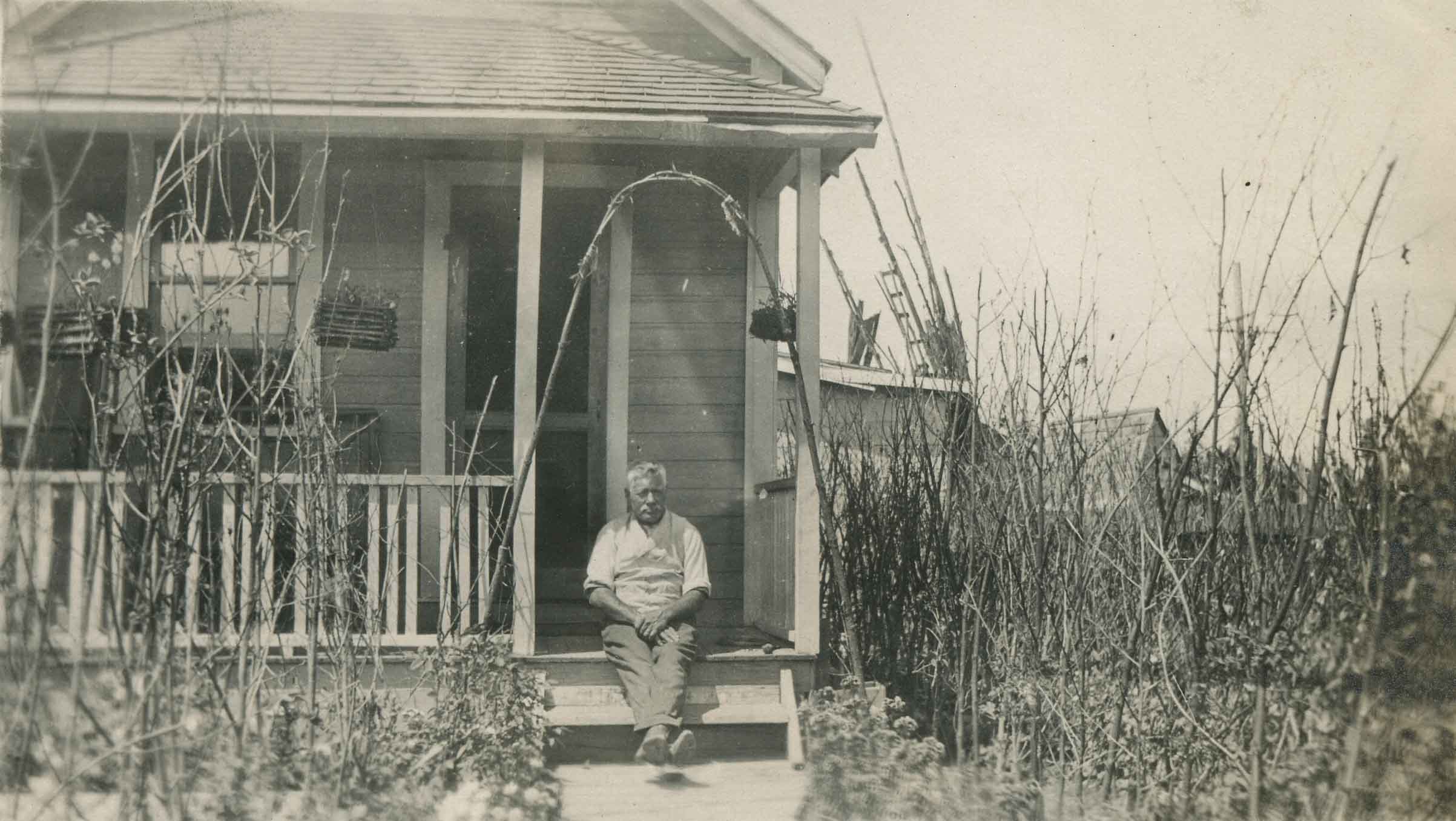
Frank Pitman house
https://search.heritageburnaby.ca/link/archivedescription35062
- Repository
- City of Burnaby Archives
- Date
- July 1, 1916
- Collection/Fonds
- Burnaby Historical Society fonds
- Description Level
- Item
- Physical Description
- 1 photograph : b&w ; 6.5 x 10.7 cm
- Scope and Content
- Photograph of Frank Pitman's house on Cassie Avenue. An annotation on the back of the photograph reads, "Cassie Ave July 1st 1916 / Home of Mr. Frank Pitman, father of Mr. Ernest Pitman." A man is seated on the front steps of the house.
- Repository
- City of Burnaby Archives
- Date
- July 1, 1916
- Collection/Fonds
- Burnaby Historical Society fonds
- Subseries
- Pitman family subseries
- Physical Description
- 1 photograph : b&w ; 6.5 x 10.7 cm
- Description Level
- Item
- Record No.
- 186-006
- Access Restriction
- No restrictions
- Reproduction Restriction
- No known restrictions
- Accession Number
- BHS1986-35
- Scope and Content
- Photograph of Frank Pitman's house on Cassie Avenue. An annotation on the back of the photograph reads, "Cassie Ave July 1st 1916 / Home of Mr. Frank Pitman, father of Mr. Ernest Pitman." A man is seated on the front steps of the house.
- Subjects
- Buildings - Residential - Houses
- Media Type
- Photograph
- Notes
- Title based on contents of photograph
- Geographic Access
- Cassie Avenue
- Historic Neighbourhood
- Central Park (Historic Neighbourhood)
- Planning Study Area
- Maywood Area
Images

Kingsway West School site
https://search.heritageburnaby.ca/link/museumdescription11122
- Repository
- Burnaby Village Museum
- Date
- March 16, 1915
- Collection/Fonds
- Ronald G. Scobbie collection
- Description Level
- Item
- Physical Description
- 1 survey plan : blueprint on paper with pencil notations ; 56 x 54 cm
- Scope and Content
- Survey plan of "Kingsway West School Site" "Burnaby Municipality" "being Lot 1, D.L.32, Lot 1 of Lot 21, Portion of Lot 21 and Portion of Lot 20, of subdivision of D.L.152, 153 & Portion of Lot 151, Group 1, New Westminster District". Notations in pencil extend along the south boundary line of Dist…
- Repository
- Burnaby Village Museum
- Collection/Fonds
- Ronald G. Scobbie collection
- Description Level
- Item
- Physical Description
- 1 survey plan : blueprint on paper with pencil notations ; 56 x 54 cm
- Material Details
- Scale: 40 feet = 1 inch
- Scope and Content
- Survey plan of "Kingsway West School Site" "Burnaby Municipality" "being Lot 1, D.L.32, Lot 1 of Lot 21, Portion of Lot 21 and Portion of Lot 20, of subdivision of D.L.152, 153 & Portion of Lot 151, Group 1, New Westminster District". Notations in pencil extend along the south boundary line of District Lot 32.
- Creator
- McGugan, Donald Johnston
- Subjects
- Buildings - Schools
- Names
- Kingsway West School
- Responsibility
- Burnett and McGugan B.C. Land Surveyors, New Westminster
- Geographic Access
- Kingsway
- Sussex Avenue
- Accession Code
- BV003.83.2
- Access Restriction
- No restrictions
- Reproduction Restriction
- No known restrictions
- Date
- March 16, 1915
- Media Type
- Cartographic Material
- Historic Neighbourhood
- Central Park (Historic Neighbourhood)
- Planning Study Area
- Maywood Area
- Scan Resolution
- 440
- Scan Date
- 22-Dec-2020
- Scale
- 100
- Notes
- Transcribed title
- Oath in bottom left corner reads: "I, D.J. McGugan...did personally superintend the survey ..." "...completed on the 16th day of March 1915", signed "D.J. McGugan" and is notarized on March 19th, 1915 by "S.F. Frank" with a seal
- handwritten on back, "1753";
- See also BV003.83.9 - duplicate blueprint plan without annotations
- See also BV003.83.3 for original plan on waxed linen
Zoomable Images

Kingsway West School site
https://search.heritageburnaby.ca/link/museumdescription11123
- Repository
- Burnaby Village Museum
- Date
- March 16, 1915
- Collection/Fonds
- Ronald G. Scobbie collection
- Description Level
- Item
- Physical Description
- 1 survey plan : blackline print on waxed linen ; 59 x 59 cm
- Scope and Content
- Survey plan titled “Kingsway West School Site" "Burnaby Municipality" / being Lot 1, D.L.32, Lot 1 of Lot 21, Portion of / Lot 21 and Portion of Lot 20, of subdivision / of D.L.152, 153 & Portion of Lot 151, Group 1 / New Westminster District".
- Repository
- Burnaby Village Museum
- Collection/Fonds
- Ronald G. Scobbie collection
- Description Level
- Item
- Physical Description
- 1 survey plan : blackline print on waxed linen ; 59 x 59 cm
- Material Details
- Scale [1:480]
- Scope and Content
- Survey plan titled “Kingsway West School Site" "Burnaby Municipality" / being Lot 1, D.L.32, Lot 1 of Lot 21, Portion of / Lot 21 and Portion of Lot 20, of subdivision / of D.L.152, 153 & Portion of Lot 151, Group 1 / New Westminster District".
- Subjects
- Buildings - Schools
- Names
- Kingsway West School
- Geographic Access
- Kingsway
- Sussex Avenue
- Accession Code
- BV003.83.3
- Access Restriction
- No restrictions
- Reproduction Restriction
- No known restrictions
- Date
- March 16, 1915
- Media Type
- Cartographic Material
- Historic Neighbourhood
- Central Park (Historic Neighbourhood)
- Planning Study Area
- Maywood Area
- Notes
- Transcribed title
- Scale on plan reads" 40 feet = 1 inch"
- Oath on plan reads: "I, D.J. McGugan...did personally superintend the survey ..." "...completed on the 16th day of March 1915", signed "D.J. McGugan", and notarized by "S.F. Mark
- See also BV0003.83.2 for digitized blueprint
Kingsway West School site
https://search.heritageburnaby.ca/link/museumdescription11130
- Repository
- Burnaby Village Museum
- Date
- March 16, 1915
- Collection/Fonds
- Ronald G. Scobbie collection
- Description Level
- Item
- Physical Description
- 1 survey plan : blueprint on paper ; 56 x 54 cm
- Scope and Content
- Survey plan of "Kingsway West School Site" "Burnaby Municipality" "being Lot 1, D.L.32, Lot 1 of Lot 21, Portion of Lot 21 and Portion of Lot 20, of subdivision of D.L.152, 153 & Portion of Lot 151, Group 1, New Westminster District".
- Repository
- Burnaby Village Museum
- Collection/Fonds
- Ronald G. Scobbie collection
- Description Level
- Item
- Physical Description
- 1 survey plan : blueprint on paper ; 56 x 54 cm
- Material Details
- Scale: [1:480]
- Scope and Content
- Survey plan of "Kingsway West School Site" "Burnaby Municipality" "being Lot 1, D.L.32, Lot 1 of Lot 21, Portion of Lot 21 and Portion of Lot 20, of subdivision of D.L.152, 153 & Portion of Lot 151, Group 1, New Westminster District".
- Creator
- McGugan, Donald Johnston
- Subjects
- Buildings - Schools
- Names
- Kingsway West School
- Geographic Access
- Kingsway
- Sussex Avenue
- Accession Code
- BV003.83.9
- Access Restriction
- No restrictions
- Reproduction Restriction
- No known restrictions
- Date
- March 16, 1915
- Media Type
- Cartographic Material
- Historic Neighbourhood
- Central Park (Historic Neighbourhood)
- Planning Study Area
- Maywood Area
- Notes
- Title based on contents of plan
- Scale on plan reads: "40 feet = 1 inch"
- Oath in bottom left corner reads: "I, D.J. McGugan...did personally superintend the survey ..." "...completed on the 16th day of March 1915", signed "D.J. McGugan", and notarized by "S.F. Mark
- handwritten on back, "1753
- See also BV003.83.2 - duplicate plan with annotations- digitized in 2020
- See also BV003.83.3 for original plan on waxed linen